Showing 531 items matching "mining history - victoria"
-
 Bendigo Historical Society Inc.
Document - VICTORIA HILL - THE RICH VICTORIA HILL AND IT'S HISTORICAL ASSOCIATIONS
Multiple handwritten and carbon copies referring to Victoria Hill. Mentioned in the notes are places of interest between Ironbark and Victoria Hill areas, history of the area and signposts for the Victoria Hill area.document, gold, victoria hill, victoria hill, the rich victoria hill and it's historical associations, j n macartney, quartz miners' arms hotel, ironbark methodist church, greek orthodox church, conrad heinz, john brown industries knitwear factory, little 180 mine, george lansell, british & american hotel, victoria reef gold mining coy, manchester arms hotel, housing commission homes, the ironbark (victoria reef gold), hercules & energetic, midway, wittscheibe, gt central victoria, wm rae, mr and mrs conroy, mrs lavery, central nell gwynne, moorhead's shop, gill family, gold mines hotel, david chaplin sterry, new chum and victoria mine, p m g repeater station, old chum mine, pioneer, rotary club of bendigo south, north old chum mine, ballerstedt's first open cut, lansell's big 180 mine -
 Bendigo Historical Society Inc.
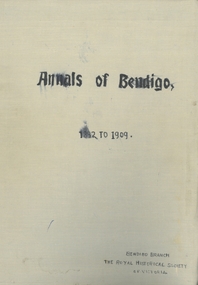
Book - ANNALS OF BENDIGO 1892 - 1909 VOLUME 3, 1892- 1909
Annals of Bendigo 1892 - 1909. 'Annals of Bendigo 1892 - 1909' Grey hard cover. Written on front cover in ink Annals of Bendigo 1892 - 1909 On bottom right written in ink Bendigo Branch The Royal Historical Society of Victoria. Published 1916George Mackayannals of bendigo, history, mining, culture, industry -
 Bendigo Historical Society Inc.
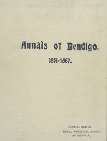
Book - ANNALS OF BENDIGO 1851 - 1867 VOLUME 1, 1851-1867
Annals of Bendigo 1851 to 1867 (1912) Printed by Mackay & Co. Market Square, Bendigo Includes maps, b/w photographs. Grey card cover. Annals of Bendigo 1851 - 1867' written in ink on front cover and on spine. Bendigo Branch Royal Historical Society of Victoria written in ink on bottom RH corner.George Mackay.bendigo, history, annals of bendigo, mining, culture, industry -
 Bendigo Historical Society Inc.
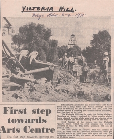
Newspaper - VICTORIA HILL - VICTORIA HILL WORKING BEE
Newspaper cutting with a photo of a working bee at the Victoria Hill site dated Tuesday, April 6, 1971. Members of Rotary, assisted by other service clubs, have cleaned up the whole area and are placing signs which explain the various mining sites on the hill. The photo shows a bulldozer pushing dirt, a group of men and the children holding signs. Article also gives a very brief history of the Hill.newspaper, bendigo advertiser, victoria hill, victoria hill working bee, south bendigo rotary club, victoria quartz mine, theodore ballerstedt -
 The Beechworth Burke Museum
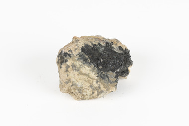
Geological specimen - Garnet crystals in galena, Unknown
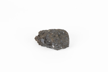
Majority of Galena in Australia is found in hydrothermal deposits emplaced around 1680 million years ago which have been heavily metamorphosed. Galena is the natural mineral form of lead sulfaide. It occurs generally as fine to large crystals due to syntectonic remobilization at low temperatures and moves to a suitable location. The colour is a shining lead and silvery gray with high specific gravity between 7.2 and 7.6 gms/cm3 and contains 86.6 lead sulfaide in its purest form. Its cyrstal system is cubic with perfect cleavages, and contract penetration and lamellar twinning. This particular specimen is from the Broken Hill mine, it is one of the largest lead mines located in Western New South Wales and still has ore reserves amounting to 20.9 million tonnes of ore grading of 7.4% lead, 9.4% zinc, and 61.5 million oz of Silver. Throughout its history, it has produced over 200 million tonnes of ore throughout its 127 years of mining history dating back to 1885. Galena mineral ore found in Australia is considered rare, as it is only currently found in the Broken Hill Mine of Western New South Wales. It represents heritage value through the systematic collecting of the geological surveyers in Victoria and Australia during the early to late 19th Century. The fact that it is only found in one mining area of Australia, shows that this specimen is rare for examples of Australian Galena. This mineral specimen is one part to a larger collection, aquistion, and distribution of Garnet in Galena around Australia and parts of the world and donated to the Burke Museum between 1860-1880. While this specimen was not found by the Victorian Geological Survey, it shows the historical need for mapping geological areas around the Gold Rush region to further identify areas of precious metal and gem aquisition. Additionally, collecting these specimens was an important part of mapping the scientific make up of the earth's surface. Many were sent to institutions for further contribution to research and scientific knowledge of the specimens. A solid coin-sized lead and zinc sulphaide and zinc silicate ore mineral in shades of black and red with shiny black points. GARNET CRYSTALS in / GALENA (lead sulphide), / SPALERITE (zinc sulphide), / WILLEMITE (zinc silicate) ore. / Locality: Broken Hill, NSWburke museum, #beechworth, indigo shire, beechworth museum, geological, geological specimen, mineral, galena, galena quartz, broken hill mine, broken hill, nsw -
 The Beechworth Burke Museum
Geological specimen - Pyrite crystals in black slate, Unknown
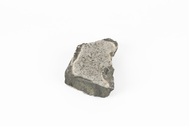
... to Victoria's gold mining history and represents through larger economic ...Pyrite also known as iron Pyrite or fools gold is an iron sulfide with a chemical formula of FeS2 and is the most abundant sulfide mineral. Its metallic luster and pale brass-yellow hue give it a superficial resemblance to gold for which its nickname of Fools Gold comes from. There are a number of iron pyrite mines in Victoria and many would have been mined during Victoria's Gold Rush revolution in the 19th century. As it's lustrius yellow metallic look closely resembles gold, it is likely that it was often mistaken for gold as real gold was also often found in similar metamorphic and sedimentary rock. This specimen is part of a larger collection of geological and mineral specimens collected from around Australia (and some parts of the world) and donated to the Burke Museum between 1868-1880. A large percentage of these collections were collected in Victoria as part of the Geological Survey of Victoria that begun in 1852 (in response to the Gold Rush). Collecting these specimens was an important part of Australia's early Geoplogical scientific discovery for mapping the earth's surface. It is unknown where in Victoria this specimen was mined from however; it shows strong provenance connections to Victoria's gold mining history and represents through larger economic and cultural structures the impact the Gold Rush had on Victoria during the 19th century. A solid coin-sized Pyrite crystal in black slate in shades of beige with tiny crystal structures. Pyrite / crystals / BB / in black slate / probably / victoria / (nice specimen)geology, geological specimen -
 Bendigo Historical Society Inc.
Photograph - AUSTIN COLLECTION: Ray Beer, Central Deborah Gold Mine
Ray Beer was an employee of the Central Deborah Gold Mine. February 15th 2009: Bendigo Advertiser: 'MINING stalwart Raymond Beer has died at the age of 74 after a battle with cancer. He leaves behind an extended family and a legacy in Bendigo’s mining history. Ray was mine manager at the Central Deborah Gold Mine - appointed in 1978 - and led the team that made possible the underground project at the second level. He had a vision to allow visitors to go underground and experience Bendigo’s mining heritage first hand. Ray was responsible for developing the new battery, shaft and poppet head to make this a reality. It took persistence and lots of hard work. Friend and work colleague Bill McNamara said Ray was as good as 10 men. His enthusiasm and work ethic were unprecedented. Ray will be sadly missed by his wife, Thelma, six children, 15 grandchildren, seven brothers, three sisters, his extended family, and friends. He will be remembered for his kindness, tenacity and strength of character. In recognition of his contribution to Bendigo’s mining history, after more than 20 years of service at his retirement, a bronze life-sized statue was unveiled in his honour'. Central Deborah Gold Mine history: At its peak, Central Deborah Gold Mine reached a depth of 412 metres. It has 17 separate levels and 15 kilometres of drives and cross cuts (tunnels). The Central Deborah was very much a hands-on mine and the conditions that the miners worked in would be considered shocking by today's standards – being lowered underground in a cage with only two sides, often working ankle to knee deep in water, filling up to 32 ore trucks a shift by hand which were then pushed a mile or more along rails in the drives, working by carbide lamp, breathing in the fumes and rock dust and communication by bells. Geez, they were ironmen. However, at the time working conditions were considered to be among the best on the goldfields at Central Deborah, after all it was one of the only mines that had hot showers. Following Central Deborah Gold Mine's closure, the Bendigo skyline began to noticeably change. Obvious remnants of mining such as poppet heads, engine rooms, service quarters, battery houses and chimneys were steadily disappearing. After intense lobbying by the local community, the Bendigo City Council purchased the still very much intact Central Deborah Gold Mine in 1970 for a mere $6,000 to ensure that a vital link to Bendigo's historic golden past was maintained. The Bendigo Trust was then formed to oversee the operations of the Central Deborah Gold Mine, which led to the surface of the mine being opened to the public in 1971. Initially the surface was open for just 12 hours a week and as the demand for viewing a part of Bendigo's history increased, so did the opening hours. In 1974 the mine was gazetted as a Public Historical Purposes Reserve and attracted such visitors as H.R.H Prince Charles. By far the greatest shortcoming at this stage was that no one could view the underground workings, as these had become flooded. After what could only be described as a monumental effort by everyone involved, Level 2 of the mine was officially opened to the public by the Premier of Victoria, the Honourable John Cain, on 20 June 1986, which brought to fruition a long standing dream.Black and white photograph. Ray Beer, underground at Central Deborah Gold Mine, standing alongside wooden sign 'Murrell's Corner'. Sign is placed horizontally on timber supports; side of drive visible in background. Ray is wearing bib and brace overalls and hard hat with a belt around his waist. He is giving a 'thumbs up' sign. gold mining, central deborah gold mine, ray beer, mine manager -
 Bendigo Historical Society Inc.
Photograph - CENTRAL NELL GWYNNE MINE
Black and white photograph of Central Nell Gwynne Mine on boundary of Ironbark. This was one of three gold mines marked for assistance to commence the mining revival. This steel poppet head previously stood over the Lightning Hill Mine and firstly over the Virginia Mine. Bendigonians can access the site from Coath Street. Inscriptions: On back - 'MNG 53', 'Nell Gwynne' in lead pencil, 'Central Nell Gwynne' in black ink', 'Royal Historical society of Victoria, Bendigo Branch' circular blue stamp. History of object: previous Acc. No. MNG 53central nell gwynne gold mine, gold mining -
Bendigo Historical Society Inc.
Photograph - AUSTIN COLLECTION: Central Deborah Gold Mine Lift Shaft
Central Deborah Gold Mine history: At its peak, Central Deborah Gold Mine reached a depth of 412 metres. It has 17 separate levels and 15 kilometres of drives and cross cuts (tunnels). The Central Deborah was very much a hands-on mine and the conditions that the miners worked in would be considered shocking by today's standards – being lowered underground in a cage with only two sides, often working ankle to knee deep in water, filling up to 32 ore trucks a shift by hand which were then pushed a mile or more along rails in the drives, working by carbide lamp, breathing in the fumes and rock dust and communication by bells. Geez, they were ironmen. However, at the time working conditions were considered to be among the best on the goldfields at Central Deborah, after all it was one of the only mines that had hot showers. Following Central Deborah Gold Mine's closure, the Bendigo skyline began to noticeably change. Obvious remnants of mining such as poppet heads, engine rooms, service quarters, battery houses and chimneys were steadily disappearing. After intense lobbying by the local community, the Bendigo City Council purchased the still very much intact Central Deborah Gold Mine in 1970 for a mere $6,000 to ensure that a vital link to Bendigo's historic golden past was maintained. The Bendigo Trust was then formed to oversee the operations of the Central Deborah Gold Mine, which led to the surface of the mine being opened to the public in 1971. Initially the surface was open for just 12 hours a week and as the demand for viewing a part of Bendigo's history increased, so did the opening hours. In 1974 the mine was gazetted as a Public Historical Purposes Reserve and attracted such visitors as H.R.H Prince Charles. By far the greatest shortcoming at this stage was that no one could view the underground workings, as these had become flooded. After what could only be described as a monumental effort by everyone involved, Level 2 of the mine was officially opened to the public by the Premier of Victoria, the Honourable John Cain, on 20 June 1986, which brought to fruition a long standing dream.Black and white photograph, looking from bottom of lift shaft towards the surface; light visible at top of shaft. Lift cables and safety mesh on sides of shaft. gold mining, central deborah gold mine, ray beer, mine manager -
Bendigo Historical Society Inc.
Photograph - AUSTIN COLLECTION: Central Deborah Gold Mine, Possibly 1990's
Central Deborah Gold Mine history: At its peak, Central Deborah Gold Mine reached a depth of 412 metres. It has 17 separate levels and 15 kilometres of drives and cross cuts (tunnels). The Central Deborah was very much a hands-on mine and the conditions that the miners worked in would be considered shocking by today's standards – being lowered underground in a cage with only two sides, often working ankle to knee deep in water, filling up to 32 ore trucks a shift by hand which were then pushed a mile or more along rails in the drives, working by carbide lamp, breathing in the fumes and rock dust and communication by bells. Geez, they were ironmen. However, at the time working conditions were considered to be among the best on the goldfields at Central Deborah, after all it was one of the only mines that had hot showers. Following Central Deborah Gold Mine's closure, the Bendigo skyline began to noticeably change. Obvious remnants of mining such as poppet heads, engine rooms, service quarters, battery houses and chimneys were steadily disappearing. After intense lobbying by the local community, the Bendigo City Council purchased the still very much intact Central Deborah Gold Mine in 1970 for a mere $6,000 to ensure that a vital link to Bendigo's historic golden past was maintained. The Bendigo Trust was then formed to oversee the operations of the Central Deborah Gold Mine, which led to the surface of the mine being opened to the public in 1971. Initially the surface was open for just 12 hours a week and as the demand for viewing a part of Bendigo's history increased, so did the opening hours. In 1974 the mine was gazetted as a Public Historical Purposes Reserve and attracted such visitors as H.R.H Prince Charles. By far the greatest shortcoming at this stage was that no one could view the underground workings, as these had become flooded. After what could only be described as a monumental effort by everyone involved, Level 2 of the mine was officially opened to the public by the Premier of Victoria, the Honourable John Cain, on 20 June 1986, which brought to fruition a long standing dream.Black and white photograph. Two men with hard hats and lights, inspecting quartz outcrop on wall of drive at Central Deborah Gold Mine.gold mining, central deborah gold mine, ray beer, mine manager -
Bendigo Historical Society Inc.
Photograph - AUSTIN COLLECTION: Operating rock drill, Central Deborah Gold Mine, Possibly 1990's
Central Deborah Gold Mine history: At its peak, Central Deborah Gold Mine reached a depth of 412 metres. It has 17 separate levels and 15 kilometres of drives and cross cuts (tunnels). The Central Deborah was very much a hands-on mine and the conditions that the miners worked in would be considered shocking by today's standards – being lowered underground in a cage with only two sides, often working ankle to knee deep in water, filling up to 32 ore trucks a shift by hand which were then pushed a mile or more along rails in the drives, working by carbide lamp, breathing in the fumes and rock dust and communication by bells. Geez, they were ironmen. However, at the time working conditions were considered to be among the best on the goldfields at Central Deborah, after all it was one of the only mines that had hot showers. Following Central Deborah Gold Mine's closure, the Bendigo skyline began to noticeably change. Obvious remnants of mining such as poppet heads, engine rooms, service quarters, battery houses and chimneys were steadily disappearing. After intense lobbying by the local community, the Bendigo City Council purchased the still very much intact Central Deborah Gold Mine in 1970 for a mere $6,000 to ensure that a vital link to Bendigo's historic golden past was maintained. The Bendigo Trust was then formed to oversee the operations of the Central Deborah Gold Mine, which led to the surface of the mine being opened to the public in 1971. Initially the surface was open for just 12 hours a week and as the demand for viewing a part of Bendigo's history increased, so did the opening hours. In 1974 the mine was gazetted as a Public Historical Purposes Reserve and attracted such visitors as H.R.H Prince Charles. By far the greatest shortcoming at this stage was that no one could view the underground workings, as these had become flooded. After what could only be described as a monumental effort by everyone involved, Level 2 of the mine was officially opened to the public by the Premier of Victoria, the Honourable John Cain, on 20 June 1986, which brought to fruition a long standing dream.Black and white photograph. Two men with hard hats and lights standing in front of underground rock surface at Central Deborah Gold Mine. Man on left hand side of image is operating a small rock drill. Man on right hand side is observing the procedure. gold mining, central deborah gold mine, rock drill, underground -
Clunes Museum
Newspaper - NEWSPAPER CUTTING, BALLARAT COURIER PTY. LTD
JAMES WILLIAM ESMOND MONUMENT.NEWSPAPER CUTTING FROM THE SUPPLEMENT TO THE BALLARAT COURIER, WITH A SCENE OF THE FIRST GOLDSTRIKE IN VICTORIA AND A PHOTO OF JAMES WILLIAM ESMOND MONUMENT AT CLUNES MARKING THE DISCOVERY OF GOLD THERE IN JULY 1851.ADVERTISEMENTS OF WILLIAM BARKELL ART & HISTORICAL CENTRE, CLUNES NEWSAGENTS, CLUNES LICENSED GROCER, NATIONAL HOTEL, MOTEL, CLUB HOTEL, CARAVAN PARK, ETC.local history, document, newspaper cutting, mining, monument -
Clunes Museum
Booklet, MAY TOWNSEND, CLUNES - VICTORIA"S FIRST GOLD TOWN
THE STORY OF CLUNES WITH SCETCHES AND POEMSYELLOW SOFT COVER COVERED WITH ADHESIVE PROTECTION OF CLEAR PLASTIC. A DRAWING ON FRONT OF CLUNES QUARTZ MINING COMPANY, NORTH SHAFT. 90 PAGES A TYPED PAGE IS GLUED IN THE BACK WITH ENTITLED "A BRIEF SUMMARY OF THE LIFE OF JAMES ESMOND" non-fictionTHE STORY OF CLUNES WITH SCETCHES AND POEMSclunes victorias first gold town, history of clunes, -
Bendigo Historical Society Inc.
Photograph - Phil Wilkin Collection - The Springs at Sedgwick 11 Items
The Phil Wilkin Collection contains a series of 11 Items. The related items can be found by clicking on the reference link below. The following history of the Young family and their descendants who lived at the Springs is provided by Phil Wilkin. His Great Grandparents were Frances Young and August Wirth. Phil has also provided notes on the Wilkin Family and some history of the gold mining in Sedgwick. Frances Young's parents Joseph and Margaret Young owned the property called "The Old Place, Preston Vale or Wellington Flat" at Sedgwick near the Springs. Joseph Young owned and Managed the Standard Brewery which was located at Campbells Creek during the late 1800’s early 1900’s. Joseph and Margaret are buried in the Harcourt cemetery. In 1880 August Wirth lived at Mosquito Creek (Lake Eppalock, Victoria) when he married Frances Young. In 1902 they moved to part of Joseph Young's property. They milked cows and sold cattle for a living. One of their children Charles Wirth (Phil Wilkin's Grandfather) bought the land in 1935 after his parents had died. Charles Wirth was a councillor and also was president of the Shire of Strathfieldsaye. The "Old Place" was part of the property owned by members of the family. The old house at the Springs was burnt out by bushfire in January 1944 and much of the stonework was later vandalized by campers. The original Coliban Water Works were designed in 1863 by the Irish engineer Joseph Brady. The system included 70 kilometres of open water channels, aqueducts, syphons and tunnels to carry water (by gravity) from the Coliban River at Malmsbury, north to Castlemaine and Bendigo. Sedgwick is a locality in Central Victoria, Australia. It is located in the City of Greater Bendigo. Facilities include a public hall that opened in 1958 and CFA Rural fire station. It was named Upper Emu Creek until 1901 when it was renamed as Sedgwick after British geologist Adam Sedgwick.The Phil Wilkin Collection contains a series of eleven Items about the Young family and their descendants who lived at the Springs and is provided by Phil Wilkin. His Great Grandparents were Frances Young and August Wirth. Phil has also provided notes on the Wilkin Family and some history of the gold mining in Sedgwick. The are 182 photos in this series and can be found at 8683.1 to 8683.11. The series also includes photos of the surrounding farming land and the remains of an old house. There are also some notes on the pioneers of the district.history, bendigo, coliban water, joseph brady, irrigation, the springs, sedgwick -
 Bendigo Historical Society Inc.
Document - HERCULES AND ENERGETIC MINES - NOTES ON THE HERCULES AND ENERGETIC MINES
Four typed copies of notes on the Hercules and Energetic Mines. Notes include Location, depth of shafts, plant and machinery, Early History and Prominence. Reference: Mines Dept Special Edition Australian Mining Standard 1.6.1899, Mines Dept Booklet Bendigo Goldfield 1936, Mines Dept Annual and Quarterly Reports, Annals of Bendigo Mining Sections 1876 - 1921, A Richardson, The Bendigo Goldfield Registry J N Macartney 1.3.1871, Mines Dept Bulletin No 30 h Herman 1914, Bendigo Amalgamated Goldfields Coy Financial Reports 1920. There are three typed copies, also the original handwritten notes.mine, gold, hercules and energetic mines, notes on the hercules and energetic mines, the north energetic, the victoria pilot, plan of leases of 1870, bendigo amalgamated goldfields company, sheepshead line, central blue, big blue, mines dept special edition australian mining standard 1.6.1899, mines dept booklet bendigo goldfield 1936, annals of bendigo mining sections 1876 - 1921, a richardson -
 The Beechworth Burke Museum
Geological specimen - Tourmaline (schorl), Unknown
Tourmaline is a group of minerals belonging to the complex borosilicate mineral class. These minerals are known for their striking and varied colours, making them prized gemstones. Tourmaline crystals can come in various shades, including pink, green, blue, brown, black, and colourless. They are often transparent or translucent. Tourmaline's chemical composition is complex, but it typically includes elements such as aluminium, iron, magnesium, sodium, lithium, and potassium. The specific arrangement of these elements in the crystal lattice gives rise to the different colours and properties of tourmaline specimens. Tourmaline specimens from Beechworth, Victoria, Australia, are a notable part of the region's mineral heritage. These tourmalines are of interest to mineral collectors and enthusiasts. While the tourmaline found in Beechworth is not as well-known as some other tourmaline varieties, it has unique characteristics and a historical context associated with the gold mining areas in Beechworth.The significance of tourmaline in Beechworth, Victoria, Australia, lies in its unique geological and historical context, contributing to both scientific and cultural aspects. The tourmaline mined in Beechworth is a rare and unique variety of tourmaline that is primarily found in the historic gold mining areas surrounding Beechworth. Its occurrence is closely linked to the geological processes that shaped the region during the Gold Rush era. The discovery of tourmaline in Beechworth adds to the rich mineral heritage of the area, which was historically known for gold mining. The specimens serve as a tangible connection to the region's mining history and contribute to preserving its geological legacy. The presence of tourmaline in Beechworth showcases the mineralogical diversity of the area. Tourmaline is known for its wide range of colours and unique properties, making it a valuable subject of study for mineralogists and geologists. Tourmaline specimens from Beechworth have educational significance, providing opportunities for research and study. They offer insights into the geological processes and mineral formation in the region, contributing to a better understanding of Earth's geological history.A hand-sized solid mineral specimen in shades of brown, green, light grey and dark greyTOURMALINE (schorl) / (Silicate of boron and aluminum) burke museum, beechworth, indigo shire, geological, geological specimen, mineralogy, tourmaline -
 The Beechworth Burke Museum
Photograph
This image is a reproduction of an 1899 original depicting the 'Williams Good Luck Mine' on the Mopoke Reef (also called 'Morepork Gully') in the Dingle Ranges, approximately three miles from Beechworth. A large opening to a mine can be seen behind the men in the photograph, with a wheeled cart on a track leading to the men's position, where the soil and rocks have been hauled away. This photograph interestingly contains dogs alongside the miners. While dogs have been recorded as deterrents to thieves in the Victorian goldfields, these dogs appear as companions to these men. Following the discovery of gold at Beechworth in 1852, rushes quickly followed at surrounding creeks and gullies in the district. In the late nineteenth and early twentieth centuries, small syndicates of miners continued to work old or abandoned quartz reefs, often persisting without the assistance of heavy machinery to remove the large amounts of rock, in order to obtain yields at ever greater depths. The group of miners in this photograph are Mr. Roger Williams and Sons, who revived operations at the ‘Old Good Luck’ mine on the Mopoke Reef in the Dingle Range near Beechworth around 1892, working the site for more than two decades. An emigrant from Cornwall with experience in the tin mining industry, 19 year old Roger Williams senior sailed to New Zealand in 1840, then to Australia where he spent time in the Bendigo Gold Fields before settling in Beechworth in the early 1860s. Mr Williams senior worked on various mining activities in the district, including the Rocky Mountain Tunnel project. Conversant with the character of gold-bearing reefs in the area, the syndicate dug an eight hundred foot tunnel, digging down as far down as two hundred feet with little capital save their labour, to connect and provide better working access to the mass of reefs and veins in the vicinity. Progress was hampered by poor air quality charged with fumes from dynamite and large quantities of rock had to be crushed to obtain payable yields. The Victorian Goldfields are filled with ruins and remnants of the area's rich mining history, ranging from small alluvial diggings to the remains of huge mining companies. Site names often changed several times throughout the nineteenth and twentieth centuries. Some sites were abandoned and forgotten, others were worked continuously over many decades. The names of mines were often repeated at different locations throughout the Victorian Goldfields. For example, there is a Mopoke Gully heritage mine near Fryers Creek, Victoria. 'Mopoke' is a common onomatopoeic name for Morepork and Australian Boobook owls.This image has historical, social and research significance for patterns of emigration during of the Victorian Gold Rush, and the historical, social and environmental impacts of mining at Beechworth at the turn of the nineteenth and twentieth centuries. As gold became scarce and government support and large company investment waned, poor hard-working miners laboured intensively to make a living through periods of high unemployment. This image can be compared and studied alongside other historical mining photographs and objects in the Burke Museum Collection. It has potential to improve our understanding of miners working conditions and the shifting character of mining in the Beechworth district.Sepia coloured rectangular photograph printed on gloss photographic paper mounted on card. Obverse: Williams/ Good/ Luck Reverse: A02498/ 1997. 2498/ Good Luck/ Mine/ 1899/ Mopoke. burke museum, beechworth museum, beechworth, gold fields, gold rush, victorian gold rush, gold ming history, colonial australia, australian gold rushes, mining technology, beechworth historic district, indigo gold trail, migration, indigo shire, good luck gold mine, victorian goldfields, mining syndicates, gold fever, quartz-mining, small-scale mining, old good luck mine, mopoke gully, quartz reefs beechworth -
 The Beechworth Burke Museum
Photograph
This image is a reproduction of an 1899 original depicting the 'Williams Good Luck Mine' on the Mopoke Reef (also called 'Morepork Gully') in the Dingle Ranges, approximately three miles from Beechworth. The foreground of the image is littered with piles of smashed rock and detritus, known as ‘mullock’, beside a reinforced mine shaft, a vertical access passageway allowing miners to enter the mine and haul ore out using lifting technology such as a poppet heads, whims or windlasses. A group of miners and a dog appear close to an open-sided miner’s hut. Following the discovery of gold at Beechworth in 1852, rushes quickly followed at surrounding creeks and gullies in the district. In the late nineteenth and early twentieth centuries, small syndicates of miners continued to work old or abandoned quartz reefs, often persisting without the assistance of heavy machinery to remove the large amounts of rock, in order to obtain yields at ever greater depths. The group of miners in this photograph are Mr. Roger Williams and Sons, who revived operations at the ‘Old Good Luck’ mine on the Mopoke Reef in the Dingle Range near Beechworth around 1892, working the site for more than two decades. An emigrant from Cornwall with experience in the tin mining industry, 19 year old Roger Williams senior sailed to New Zealand in 1840, then to Australia where he spent time in the Bendigo Gold Fields before settling in Beechworth in the early 1860s. Mr Williams senior worked on various mining activities in the district, including the Rocky Mountain Tunnel project. Conversant with the character of gold-bearing reefs in the area, the syndicate dug an eight hundred foot tunnel, digging down as far down as two hundred feet with little capital save their labour, to connect and provide better working access to the mass of reefs and veins in the vicinity. Progress was hampered by poor air quality charged with fumes from dynamite and large quantities of rock had to be crushed to obtain payable yields. The Victorian Goldfields are filled with ruins and remnants of the area's rich mining history, ranging from small alluvial diggings to the remains of huge mining companies. Site names often changed several times throughout the nineteenth and twentieth centuries. Some sites were abandoned and forgotten, others were worked continuously over many decades. The names of mines were often repeated at different locations throughout the Victorian Goldfields. For example, there is a Mopoke Gully heritage mine near Fryers Creek, Victoria. 'Mopoke' is a common onomatopoeic name for Morepork and Australian Boobook owls.This image has historical, social and research significance for patterns of emigration during of the Victorian Gold Rush, and the historical, social and environmental impacts of mining at Beechworth at the turn of the nineteenth and twentieth centuries. As gold became scarce and government support and large company investment waned, poor hard-working miners laboured intensively to make a living through periods of high unemployment. This image can be compared and studied alongside other historical mining photographs and objects in the Burke Museum Collection. It has potential to improve our understanding of miners working conditions and the shifting character of mining in the Beechworth district.Sepia coloured rectangular photograph printed on gloss photographic paper mounted on card.Obverse: Reverse: A02497/ 1997.2497/ 'Good/ Luck/ Mine'/ Morepork/ Gully/ Mrs Joyce/ Bright/ Tunnel/ 800 ft/ 1899. burke museum, beechworth museum, beechworth, gold fields, gold rush, victorian gold rush, gold ming history, colonial australia, australian gold rushes, mining technology, beechworth historic district, indigo gold trail, migration, indigo shire, good luck gold mine, victorian goldfields, mining syndicates, gold fever, quartz-mining, small-scale mining, old good luck mine, mopoke gully, quartz reefs beechworth -
 Clunes Museum
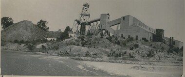
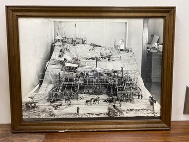
Photograph, PORT PHILLIP MINE MODEL
FRAMED PHOTOGRAPHS OF MODEL OF PORT PHILLIP & CLUNES MINE AND SIGN USED WHEN ON DISPLAY .1 PHOTO OF FULL MODEL .2 PHOTO OF BACK OF MODEL .3 PHOTO OF CLOSE UP OF BUILDING WHICH HAS NO OUTER WALLS OR ROOF TO ENABLE VIEW OF INSIDE. .4 HAND WRITTEN SIGN, FRAMED MODEL MADE IN 1858 BY CARL NORDSTROM ON SITE . MODEL NOW IN STORAGE AT SCIENCE MUSEUM OF VICTORIAlocal history, photographs, mining -
 Bendigo Historical Society Inc.
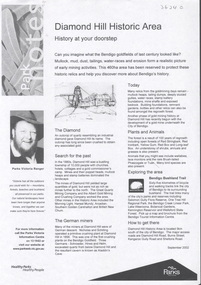
Document - DIAMOND HILL HISTORIC AREA PARKS VICTORIA
Document, two pages, prepared by Parks Victoria in relation to the Diamond Hill Historic Area. Contains information regarding the history of the area; German Miners; Plants and animals. On second page is a map of the area showing historic features: Deborah Consolidated Gold workings Red, White and Blue Extended gold workings Goldfields Extended gold workings Dead Dog Gully, alluvial gold workings Glasgow & Golconda Gold workings and tramway Surface gold mining site Hansel Mundy gold workings Bendigo Goldfields Pty gold workings Stafford gold workings Langdon gold workings Great Opossum Gully alluvial gold workingsbendigo, mining, diamond hill -
 Clunes Museum
Photograph
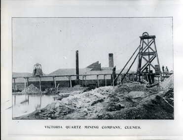
... local history photography photographs mining VICTORIA ...BLACK AND WHITE REPRODUCED PHOTOGRAPH. VICTORIA QUARTZ MINING COMPANY, CLUNES. LARGE POPPET HEAD ON RIGHT OF PHOTOGRAPH, BUILDING WITH TWO CHIMNEYS IN CENTRE, SMALLER POPPET HEAD ON LEFT OF PHOTOGRAPH.VICTORIA QUARTZ MINING COMPANY, CLUNESlocal history, photography, photographs, mining