Showing 12454 items
matching now and then
-
 Port Melbourne Historical & Preservation Society
Booklet, Open Space 2000. Bay to ranges, Caring for Port Phillip Bay. Now and into the future, 2000
"Caring for Port Phillip Bay. Now and into the future" Booklet with blue and white cover and coloured map of Port Phillip Bay and surrounding area.natural environment, maritime, port phillip bay -
National Vietnam Veterans Museum (NVVM)
Film - Film, DVD, Photos from the Vietnam War in 1966-1967
Photos & a video of the War. Also contains a Film, DVD titled, Vietnam revisited: now & then. Oct 04-Nov 07. by Ian Ryanvietnam war, 1961 - 1975, personal narratives - australian, 6rar, ian ryan -
 Port Melbourne Historical & Preservation Society
Photograph - Excelsior Hall, completed conversion to housing units, Glen Stuart, 2005
Photo taken by Glen Stuart in 2005. Photo taken from Bridge St of completed renovations of Excelsior Hall - now housing units.built environment - civic, excelsior hall, rsl, returned services league, public housing -
Port Melbourne Historical & Preservation Society
Painting - Sandridge Town Pier, watercolour by SM, 1985
One of ten framed watercolour paintings of Port Melbourne buildings by 'S.M.' c 1985: 'Sandridge Town Pier (now Port Melbourne)'built environment - civic, built environment - commercial, piers and wharves - town pier, arts and entertainment - visual arts, tony hill, mcclusky and associates - solicitors, painting -
 Coal Creek Community Park & Museum
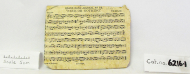
Sheet Music, Brass Band Journal No.58
(2) music sheets glued onto cardboard, from Brass Band Journal No.58 Titles: "Neck or Nothing" and "Everybody's Doing it Now" -
 Bendigo Historical Society Inc.
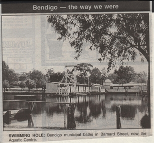
Newspaper - JENNY FOLEY COLLECTION: SWIMMING HOLE
Bendigo Advertiser ''The way we were'' from 1999. Swimming hole: Bendigo municipal baths in Barnard Street, now the Aquatic Centre.newspaper, bendigo advertiser, the way we were -
 Bendigo Historical Society Inc.
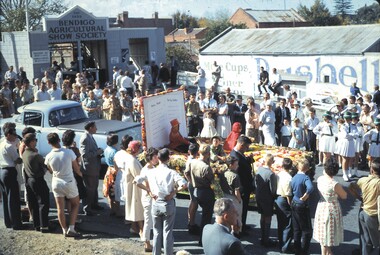
Slide - BENDIGO EASTER PARADE, Apr 1962
Slide. Bendigo Easter Parade. The Toy Soldier float. At the end of the parade on the site of the former Show Grounds (now the Tom Flood Centre).slide, bendigo, bendigo easter parade., bendigo easter parade. -
Tatura Irrigation & Wartime Camps Museum
Folio, Tatura Museum, 1995
Record of progress on Bill Doller Room 1991Work in progress at museum. Photographic records of same opening day, also early handwritten list of irrigation photos (Now displayed elsewhere)building museum, documents, reports -
 Robin Boyd Foundation
Slide, Robin Boyd, 1967
Robin Boyd was an invited speaker at the 1967 New Zealand Institute of Architects Conference held in Queenstown, New Zealand. From New Zealand, he travelled on to Montreal, Canada, where he was Exhibits Architect for the Australian Pavilion at Expo ‘67. Colour slide in a mount. Freyberg Place and the Pioneer Women’s Memorial Hall (now called Ellen Melville Centre), Auckland, New ZealandMade in Australia / 37 / APR 67M7slide, robin boyd -
 Clunes Museum
Photograph
COLOURED PHOTOGRAPH TAKEN BELOW FORD AT END OF FRASER STREET. AREA NOW USED AS PICNIC AREA ON CREEK BANK ON BLACKMORE ROAD.local history, photography, photographs, clunes landscape -
 Whitehorse Historical Society Inc.
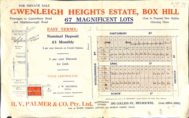
Document, Gwenleigh Heights Estate, Box Hill, unknown
Land plan of 67 allotments for sale between Canterbury Road, Middleborough Road and Agnew Street, Box Hill. (Now Blackburn South)land subdivision, middleborough road, blackburn south, canterbury road, agnew street, aberdeen road, h. v. palmer (estate agent) -
Whitehorse Historical Society Inc.
Article, Probus clubs, 1991
Interest in Nunawading's Probus Clubs is increasing.Interest in Nunawading's Probus Clubs is increasing. The latest club formed is Blackburn Central Probus Club. There are now ten Probus Clubs in Nunawading.Interest in Nunawading's Probus Clubs is increasing. clubs and associations, blackburn central probus club -
Whitehorse Historical Society Inc.
Newspaper - Article, The Whitehorse Post, Church celebrates 110 years
Article from Whitehorse Post on celebration of 110 years of worship at the Methodist Church, Box Hill, now known as Wesley Uniting Church.box hill methodist church, churches, box hill, wesley uniting church, box hill, dickie, john, dickie, ruth, mcmurdie, david, hammon, marg, molyneux, betty, clark, nancy -
Whitehorse Historical Society Inc.
Article, True believer, 2010
Story of Waleed Aly, who grew up in Vermont and is now a Mitcham resident.Story of Waleed Aly, who grew up in Vermont and is now a Mitcham resident. He is an academic, writer, rock musician and radio commentator.Story of Waleed Aly, who grew up in Vermont and is now a Mitcham resident. aly, waleed -
Whitehorse Historical Society Inc.
Newspaper - Article, Pioneer home, n.d
[Photograph] taken in 1886 of 'Elm Grove' occupied by John and Mary Ann Talbett and family, in Britnell's, now Middleborough Road. [Newspaper cutting].wattle and daub, talbett, john, talbett, mary ann, elm grove, britnell's road, middleborough road -
 Whitehorse Historical Society Inc.
Photograph, Old Dam corner Blackburn and Canterbury Roads, c1910
Original photo at Blackburn Lake Education Centre. Dorothy Meagher loaned photo so a print could be made.Black and white photograph of dam being built on the south west corner of Canterbury and Blackburn Roads, Blackburn. Bellbird Hospital is now on this site.canterbury road, blackburn, blackburn road, blackburn lake education centre, meagher, dorothy, bellbird private hospital -
 Whitehorse Historical Society Inc.
Photograph, Old House, 1982
Coloured photo of Old House in Burwood Highway, East Burwood. West of Springvale Road. Mullens Orchard & home. House now demolished.orchards, mullens -
 Whitehorse Historical Society Inc.
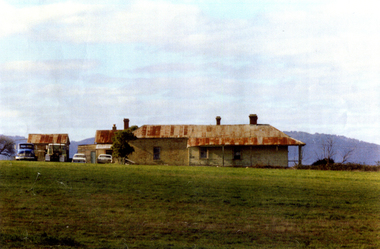
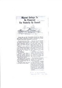
Legal record - photocopy, Migrant Cottage, 1/07/1964 12:00:00 AM
In 1964, the City of Nunawading purchased what is now known as Schwerkolt Cottage and John and Phyllis Murphy were commissioned to be in charge of its restoration.In 1964, the City of Nunawading purchased what is now known as Schwerkolt Cottage and John and Phyllis Murphy were commissioned to be in charge of its restoration.In 1964, the City of Nunawading purchased what is now known as Schwerkolt Cottage and John and Phyllis Murphy were commissioned to be in charge of its restoration.schwerkolt cottage, murphy, john, phyllis, city of nunawading, green, ken -
 Whitehorse Historical Society Inc.
Article, Birds, 8/11/1993 12:00:00 AM
Gazette, 8 November 1993 on bird life in bushland off Stanley Road, Forest Hill.Article from the Gazette, 8 November 1993 on bird life in bushland off Stanley Road, Forest Hill.(Now in Vermont South)Gazette, 8 November 1993 on bird life in bushland off Stanley Road, Forest Hill.birds, stanley road, vermont south -
 Whitehorse Historical Society Inc.
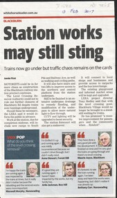
Article, Blackburn Level Crossing, 2017
Trains now travel under Blackburn Road but further construction work could require further closures to Blackburn Road later this year.level crossing removal authority, blackburn, blackburn road -
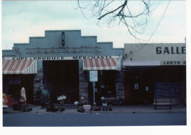 Whitehorse Historical Society Inc.
Photograph - Coloured Photograph, Raftis Store Blackburn, 1983
Coloured print from a 35mm slide of WR & RE Raftis's Fuel and Produce Store in South Parade Blackburn in 1983 - now demolishedsouth parade, blackburn, raftis, w.r & r.e., fuel and produce merchants -
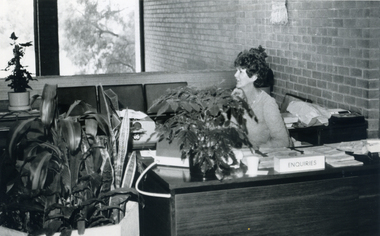 Whitehorse Historical Society Inc.
Photograph, Reception desk - Nunawading Council, c 1988
Black and white photograph of the receptionist at the reception desk at the original Nunawading Council building (now the Library) c 1988. This was an open area officecity of nunawading -
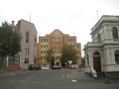 Ballarat Heritage Services
Photograph - Colour, L.J. Gervasoni, State Offices, Camp Street, Ballarat, 25/07/2015
The statue of Perseus has been removed since this photograph was taken.Colour photograph of the Ballarat State Offices / Court House in Camp Street, Ballarat. This building is now part of the Federation University Arts Academy.art deco, statue, ballarat, camp street, state office, ballarat court, perseus -
 Lakes Entrance Regional Historical Society (operating as Lakes Entrance History Centre & Museum)
Photograph, 1999
Site of lime burning operations from 1870's. Lime burnt for agricultural purposes. Cocky Roberts was using lime in his glass making business at Lakes Tyers.Colour photograph of the McCrae Lime Kiln site east side shows work site now encroached on by bushland. Toorloo Arm Victoriawater supply -
 Lakes Entrance Regional Historical Society (operating as Lakes Entrance History Centre & Museum)
Photograph, 1906c
Most names are listed in filesBlack and white photograph of twenty one members of the Salmon Company, now the Cunninghame Co-operative Fishermens Society. Lakes Entrance Victoriafishing industry, coast, clothing -
Lakes Entrance Regional Historical Society (operating as Lakes Entrance History Centre & Museum)
Photograph, M Holding, 1/11/1999 12:00:00 AM
Colour photograph of Riverslea a former guest house now private residence situated on corner of Tambo Upper Road and Swan Reach Victoriatourism, township, accommodation -
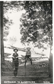 Mt Dandenong & District Historical Society Inc.
Photograph, Entrance To Sunnyside, c1915
J. G. Roberts with his son Bert (sitting on gate) at the entrance to his country home Sunnyside at South Sassafras (now Kallista).Entrance To Sunnyside GGMj g roberts, bert roberts, sunnyside, south sassafras -
 Kew Historical Society Inc
Plan - Subdivision Plan, J R Mathers & McMillan, Plan of Subdivision of Part of Crown Portion 83 at Kew : LP6669, 1923-1939
In 1888, in the section of Park Hill Road between Belmont Avenue and Normanby Road there was only one street running between Park Hill Road and Cotham Road. This was Park Road, later to be named Adeney Avenue. Subsequent 20th century subdivisions created the ‘through roads’ of Cecil Street, Wimba Avenue, Florence Avenue, Marshall Avenue, Uvadale Road, and Barrington Avenue. This subdivision represents an attempt by auctioneers, rather than town planners to create an urban environment from larger residential allotments or in many cases farmland. Existing streets such as Parkhill and Normanby Roads provided a convenient starting point for the surveyors, but the Road named ‘Street Street’ indicates the role of the private surveyor in creating streets. Given that a number of allotments are listed as sold on the plan, the street is presumably Cecil Street. Even those lots that had been sold do not quite match the dimensions of the blocks in this parcel of land today, indicating that either further subdivisions or boundary alterations occurred.Subdivision plans are historically important documents used as evidence for the growth of suburbs in Australia. They frequently provide information about when the land was sold as well as evidence relating to surveyors and real estate and financial agents. The numerous subdivision plans in the Kew Historical Society's collection represent working documents, ranging from the initial sketches made in planning a subdivision to printed plans on which auctioneers or agents listed the prices for which individual lots were sold. In a number of cases, the reverse of a subdivision plan in the collection includes a photograph of a house that was also for sale by the agent. These photographs provide significant heritage information relating house design and decoration, fencing and household gardens.The photograph may also be aesthetically significant depending on the importance of the photographic atelier.Hand-drawn subdivision plan of 19 lots facing Parkhill Road, Normanby Road, and an unnamed street [now Cecil Street] in Kew.Estate Agent notes in ink indicate those lots which had sold.subdivision plans - kew, parkhill road - kew, cecil street - kew, normanby road - kew, cecil street -kew, parkhill road - kew, normanby road - kew, crown portion 83 - kew -
 Kew Historical Society Inc
Slide - 'Tarring', Ruyton Girls' School, 1979
One of a group of slides taken by members of the Society of built heritage in Kew in 1979-80. The selection of subject matter reflects the priorities of the period. The colour of some slides has degraded.The slides represent a snapshot in time of built architecture in Kew, much of which has changed in the forty-plus period since they were created. 35mm colour transparency (slide) of 'Tarring' on the corner of Wellington Street and Selbourne Avenue; now part of Ruyton. The photo was developed in May 1979.ruyton girls' school, tarring, schools -- kew (vic.) -
 University of Melbourne, Burnley Campus Archives
Photograph - Black and white print, View Across Garden to Principal's Residence, 1913
Note by T.H. Kneen 19 November 1991, "View of Principal's residence from vicinity of orchard gate - the three steps in altered form still exist (1991). Middle ground plantation of camellias still exists."Looking across garden area from the Orchard with path and shrubs to back of Principal's Residence in background. There are more steps than are extant now.On reverse, "1913." principal's residence, lynch design, camellias, principal's house, orchard, field station