Showing 1568 items matching "off road"
-
 Glenelg Shire Council Cultural Collection
Photograph - Sheet of 2 contact prints from glass plate negatives, 1960-1970
Sheet of 2 contact prints from glass plate negatives. Each Print measuring 11.8 x 16 cm Top: Close up of front of Portland Post Office, corner Bentinck and Cliff Streets. Horse and buggy at right, several people standing in front of Post Office. Bottom: Dutton Way beach looking towards Portland. Road along top of beach, fenced off from beach. Horse tethered to fence. -
Glenelg Shire Council Cultural Collection
Photograph - Photograph - The Brooksby, Sep-87
Possibly from Bowerbird MuseumColoured photograph of candle stick from 'the Brooksby' and Andrew Herbertson's log, on table, candlestick on crocheted doiley, wallpapered wall behindFront: 'Candle off "The Brooksby" when Andrew Herbertson sailed from Glasgow to Australia on 9th July 1852. Andrew Herbertson's Log commenced when he left for Autralia' 'Photograph taken Sept 1987' Printed by hand black - fine point biro -
Glenelg Shire Council Cultural Collection
Tool - Pocket Knife, n.d
Pocket knife, promotional item from 'Hudson's Stores - Home of the Old Henty Plow'. Depicitons on handle, mostly worn off, blade rusty.advertising, portland business, hudsons stores -
Glenelg Shire Council Cultural Collection
Flyer - Flyer - Casterton & Coleraine Hunt club, c. 1969
Off white paper flyer, Casterton-Coleraine Hunt Club, advertising Point to Point race on Sunday August 24, 1969.casterton, coleraine, hunt, sport, recreation -
Glenelg Shire Council Cultural Collection
Domestic object - Hair Comb, n.d
Tortoiseshell hair com, translucent honey coloured, 3 teeth (one broken off) comb wave-shaped. -
Glenelg Shire Council Cultural Collection
Equipment - Equipment - Fishing Float, n.d
Wooden painted 'pencil' fishing float. Bottom section lacquered, the rest including central barrel-shaped section, red-brown. Metal loop just above barrel-shaped section, for passing fishing line through. ? section with other loop broken off bottom section -
Glenelg Shire Council Cultural Collection
Domestic object - Hair Comb, n.d
Dark brown bakelite hair comb, 8 teeth on hinge (part of one broken off), comb curved with bakelite chain across width. 5 black ?plastic balls attached to scalloped edge below chain -
Glenelg Shire Council Cultural Collection
Souvenir - Souvenir - Vinyl Sticker Portland Harbour, n.d
Formerly Bower Bird Museum, HeywoodRectangular card with removable oval-shaped vinyl sticker in the centre. Sticker has an image of several wind-surfers in Portland Harbour off Henty Beach , Trawler Wharf and Fisherman's Breakwater in Background. Round hole for hanging, top centre . Pink border, pink "Portland', top centre of stickerFront: Yellow logo' 'Australia collectors choice Murray Views; in black Souvenir vinyl stick-ons, black print $1 blue texta -
Glenelg Shire Council Cultural Collection
Plan - Ship Plan / Mould, n.d
Wooden, pattern for moulds for boat fittings. 'Waisted' cylinder: made in two parts, held together by wooden dowels; unpainted.Front: Inside of 1 piece - 'RON STEWART PORTLAND' - blue biro Other piece - '1 OFF brass' - blue biro Back: Outside of 1st piece -'bore hole -11/16 1 off' - pencil -
Glenelg Shire Council Cultural Collection
Plan - Ship Plan / Mould, n.d
... Cliff Street Portland great-ocean-road Front: '1 OFF' 'CORE ...Wooden pattern for mould for boat fitting. Flat base, two arch shaped sections, dissected by a rectangular section, nailed together. Unpainted.Front: '1 OFF' 'CORE PRINT' - pencil -
Glenelg Shire Council Cultural Collection
Plan - Ship Plan / Mould, n.d
... Cliff Street Portland great-ocean-road Back: '16 OFF' - black ...Wooden pattern for mould for boat fitting. Same as 6358, but different size.Back: '16 OFF' - black texta -
Glenelg Shire Council Cultural Collection
Plan - Ship Plan / Mould, n.d
... Cliff Street Portland great-ocean-road Back: '1 OFF 1 ...Wooden pattern for mould for boat fitting. Same as 6353.Back: '1 OFF 1¾ "....' black texta -
Glenelg Shire Council Cultural Collection
Plan - Ship Plan / Mould, n.d
... Cliff Street Portland great-ocean-road Back: '6 OFF' - black ...Wooden pattern for mould for boat fitting. Rectangular base; round shaped piece attached to top, painted orange.Back: '6 OFF' - black texta '169' - pencil -
Glenelg Shire Council Cultural Collection
Plan - Ship Plan / Mould, n.d
... Cliff Street Portland great-ocean-road Back: '20 OFF' - biro ...Wooden pattern for mould for boat fitting. 8 pointed 'star' shape, around a cylinder, which protrudes further on front than back. Painted khaki.Back: '20 OFF' - biro -
Glenelg Shire Council Cultural Collection
Plan - Ship Plan / Mould, n.d
... Cliff Street Portland great-ocean-road Back: '2 off Brass ...Wooden pattern for mould for boat fitting. 'H' shaped with flat base. Painted pale pink.Back: '2 off Brass' - pencil -
Glenelg Shire Council Cultural Collection
Plan - Ship Plan / Mould, n.d
Wooden pattern for mould for boat fitting. Rectangular block, squared off corners, made in two halves held together with wooden dowels. Inside each block semi circular groove, so when halves joined together, there is a circular hole through the block. Painted orange. -
Glenelg Shire Council Cultural Collection
Document - Document - Ball Tickets Golden Anniversary Ball Port of Portland 50th Anniversary, Nov-10
Two tickets to the Golden Anniversary Ball for the Port of Portland's 50th Anniversary. Cardboard, multi coloured, tear-off section with ticket number. 6655a No. 300, 6655b No. 301. -
 Greensborough Historical Society
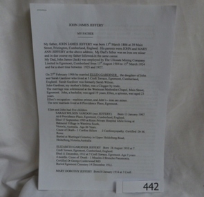
Genealogical document, John James Jeffery, 1957o
Details the life and family history of John James Jeffery, his English roots and his time in Greensborough as a poultry farmer. Prepared by his son John Jefferey in 2008.Gives the origin of Jeffery Court, (off Nepean St).2 x A4 pages.Family history of John James Jeffery, john james jeffrey, poultry farm, nepean street, greensborough, arthur street greensborough. -
 Halls Gap & Grampians Historical Society
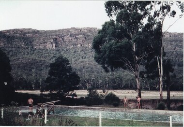
Photograph - Coloured, C 1960
Jack Deller at end of diving board Graeme Chappell diving off of board Darryl Williams left and Doug Bottoms right opposite side of pool Occasion was Graeme's 21st birthdayPeople enjoying pool and diving board at Myrtlebank Guest House overlooked by Mt William Range.AGFApeoplerecreation, sport -
 Halls Gap & Grampians Historical Society
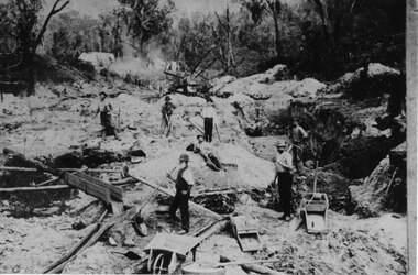
Photograph - Sepia, C 1900
Horton's Reward Claim. This group of miners also worked another area called 'The Heather Bell" approx. 200 yards further up the gully. About half a pennyweight to the dish is obtained from the wash near the creek. They are panning off 3 dwts per day off one man's ground. This claim is about the best fitted up on the field. It is worked with a sluice box with iron ripples and feeder to match. The latter is a great advantage as there is a great fall below the claim for the tailings.Photo shows seven men working a goldfield using shovels and picks.mining, mount william, people -
 Halls Gap & Grampians Historical Society
Map - Coloured
Background on Bridle Path up Stony Creek Gorge Pre 1840 C. B. Hall, squatter on Mokepilly Run 1841-1842, first European to discover the Fyans Creek valley, the entrance of which became known as Hall's Gap. He later recorded that he followed a number of tracks which he assumed had been made by the Aboriginies and described one as "leading up a wild romantic glen and over on to the source of the Glenelg River". This could well have been the route taken up Stony Creek gorge by the first timber-cutters in this part of the Grampians to the saddle between the Wonderland and Mt. Difficult ranges known as Valley Gap 1850s/60s Timber cutters and shingle splitters were reported to be moving into the eastern side of the Grampians and by the mid 1860s there were a number of families connected to the supplying of timber to Pleasant Creek living in the "Hall's Gap ranges". John Wakeham, the first store owner in Pleasant Creek in 1854, established a timer-mill in upper Stony Creek Gorge in the late 1850s. Wakeham is credited for the clearing and levelling of the first bridle-path up the gorge. 1870s By the mid 1870s the track had been extended over Valley Gap to the Victoria Forest (the upper region of the Victoria Valley). McKeon's bullock team was known to have hauled red gum from the Valley to Stawell in the late 1870s and the 1880s. 1880s In 1887 an article in the Pleasant Creek news describes the Stony Creek Gorge track as "being a ledge alongside the mountain range, formed in the early days with the aid of earth and timber, along which the bullock teams used to travel to Horsham and plains of the Wimmera beyond." 1890s Gold was discovered in the catchment area of Stony Creek and by the end of the 1890s a new track was built from "near the junction of Fyan's and Stony Creeks, up the gorge to the diggings settlement. The mining Department had paid L300 for its construction and, when completed, the track was "three miles and 30 chains in length, the side cuttings at the narrowest part being 10 feet between" and "the watercourses which cross the track at various points" having been "filled up with rocks rolled down the sides of the hills, and consequently there can be no damage caused by bushfires which destroyed the former wooden bridges erected on the old track to Wakeham's saw-mill, the remains of which are still to be seen at the side of the diggings" The article goes on to further describe the track as one which "can with ease travel with a two horse conveyance either up or down" and that the workmen engaged in the construction of the track would be attending "a ball that night at McKeon's farm near the mouth of the gap to celebrate the successful completion of the undertaking". 1900s At what time the bridle path was extended beyond Valley Gap to the Wartook basin on the Mt. Difficult Range has not yet been determined. However, it is known that, by the turn of the century, people were travelling between Halls Gap and the caretakers' residence at Wartook Reservoir along what was now known as the "Bluff Road. Wartook's embankment had been constructed in 1887 and at that time there was already a track from Rosebrook Station homestead (near the present day Wartook Pottery) to the reservoir. Philip Rose owned both Rosebrook and Wartook Stations from the mid 1840s to the late 1850s and had regularly leased the Wartook basin to Cobb & Co. to rest horses there. 1920s Following the war of 1914-1918, tourism really took off in the Grampians, and Halls Gap rapidly grew. People would travel as far as they could on the many tracks then hike to the many lookouts being discovered by local tour guides. This led to the need for access across the range so that horse riders and the increasing number of vehicles could travel between Horsham and Halls Gap. To this end, the Bluff Road was improved and extended on 1929 and at its opening in March, 1930, by Lady Somers it was renamed the Mt. Victory Road.Map of Mt Victory Road and othersaccess routes, mt victory rd, bridle path, roads -
 Halls Gap & Grampians Historical Society
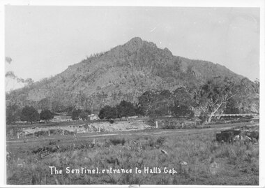
Photograph, C 1910s
This is a picture of Sentinal Peak, showing Delley's Bridge and Delley's house. This is the second bridge built over Fyans Creek in 1911. The house is Delley's Inn, which became a regular stop-off for thirsty travellers.The photo shows a rocky peak. In the middle distance, in front of the peak, is a house on the left and on the right a wooden bridge can be seen crossing a creek. In the foreground is the creek with a fenced paddock in front of it.access routes, roads, scenery, peaks -
 Halls Gap & Grampians Historical Society
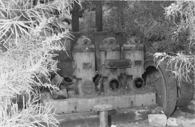
Photograph - Coloured, C 1980s (?)
Photo shows close up view of steam equipment. Three iron chimneys attached to equipment are cut off from view at top of photo. Wattle in bloom can be seen on both sides of photo.quarrying, heatherlie -
 Halls Gap & Grampians Historical Society
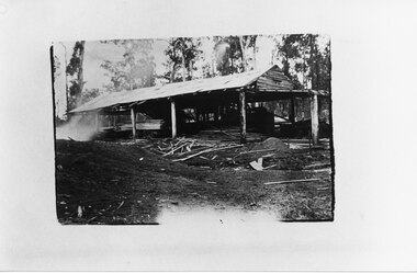
Photograph - B/W, C 1910
Unknown timber mill in the Grampians.The photo shows an open sided building. In the building there is cut wood stacked on a trolley to the left with further, further cut wood in front of it. A steam engine can be seen in the far side of the building. Off-cuts and saw dust are visible in front of the building.timber industries, logging, sawmilling -
 Eltham District Historical Society Inc
Photograph, Spring Excursion, Hume and Hovell bus tour Stage 2, Seymour, Benalla; 26 Oct 1997, 26/10/1997
MONUMENT HUNTING THE HUME AND HOVELL WAY (Newsletter No. 117, November 1997, by Diana Bassett-Smith) Sunday October 26 1997 dawned bright and very warm. Some twenty-five members, complete with picnic baskets, met outside the Eltham Library awaiting the Cobb and Co. large coach which would be taking us on the second leg of our travels along the route of the early explorers Hume and Hovell. Stephen West was our very good driver for the day. He would be guided around the circuitous route by Russell Yeoman wh9 had made a detailed study, not only of the intended route, but of the story of these two explorers. During the trip Russell regaled us with poetry, quotations from the Journals and the History of the Shire of Seymour, "The New Crossing Place: by Martindale, 1982, (now Mitchell Shire due to the recent amalgamations). We headed towards the Hume Highway via Greensborough and Cooper Street and proceeded north to our first stop, noting on the way Monument Hill in the distance which is near Kilmore and, according to Russell, well worth the effort to visit as the view across the valley is magnificent. Past Sunday Creek Valley, Mt Piper and Mt Disappointment, all traversed and noted and named by them. We passed through Tallarook, then onto Seymour where we took photos of the monument telling us that Hume and Hovell had passed through on the 28th of October 1824. We also deviated down Hume and Hovell Road viewing deer and emu farming and the Bellbourie property now a sanctuary. Leaving Seymour behind we travelled up the Avenel Road to the Avenel monument, pyramidal in design of four reducing square blocks with a sharply pointed peak, erected in 1924 in memory of the 1824 exploration. The day was warming up and the countryside showing the dryness of the current drought. A parallel note had been made in their journal too of 1824 of the drought appearance of the country they were traversing. At Seven Creeks, Euroa we stopped for some minutes to check the monument placed 20th November 1924 to commemorate their passage on the 29th December 1824. More photos. Russell had pointed out the abrupt termination of the distant ranges which is noted in their journal. The next monument is beside the road at the entrance to Honey Suckle Creek Caravan Park, Violet Town. The squarish shaped monument some eight feet high is topped with a simple steel cross, and was to mark the date of 28th December 1824 and built for the 20th November 1924. By now it was 12.20 and nearly lunchtime as we drove along the Warranbayne Road to Roach's Road, monument hunting without success. Though there is a large, what appears to be an old timber sign which was hard to read, maybe this was the lost monument. In many of the paddocks hay had been cut and baled or was being cut, what a contrast to the rugged country they had passed through which was smoky from the fires of the natives burning off By 1.00 pm we were at Benalla and pulled up beside the park where abundant beds of roses filled the air with their scent and the smell of barbecued food twitched the nostrils whilst the cheerful sounds of other picnickers could be heard throughout the park. We left the bus and collected up our picnics, dispersed to the various tables and enjoyed the shade from the various European trees. 2.00 pm and we were on the road again driving along the Benalla, Mansfield, Yea road. The Swanpool monument states that they passed four miles south and returned three miles north. Then we stopped at the Barjarg monument which notes that they camped near this spot. It is again a pyramidal monument and this time topped with a steel arrow indicating their route of the 29th November 1824. Half an hour later we came to another monument, again with a steel arrow marker on top and the plaque dated the 2nd of 12th 1824. Erected on the 12th of 12th 1924. "They blazed the way that we might inherit the land." Another square based and needle topped monument appeared at Yarck near Yea and this plaque records the date of 3 December 1824. Near McGuigans Road Russell related that the expedition had lost a dog but it had found them next day, the dog was apparently torn by a kangaroo. A short while later Russell reminded us here of the problems they encountered in crossing the Goulburn River near Molesworth where banks were high, water deep and wide. "Good coat of grass but quite dry due to drought". At Yea we stopped for afternoon tea and raided the last of our picnics and looked at the monument to their journey of 1824, situated at a corner of the gardens near the bowling green. No photo – we were out of film. We returned home via Kinglake West and Whittlesea past the Yan Yean Reservoir, not full. 5.00 pm back at Eltham we emptied out of the bus and everyone, including Joan Cole, collected their things, Joan also had the major souvenir of the day, a large carp she had picked up from the river bank, her cat was in for a great feast. The day was made so interesting by the informed commentary which Russell provided. His background knowledge of the route and nature of the journey could only have come from many hours of reading and driving the area. Thank you to Russell and to everyone who made the day so informative and pleasurable. Diana Bassett-Smith. Record of the Society's history of activities - Spring 1997 excursionRoll of 35mm colour negative film, 6 stripsFuji 200shire of eltham historical society, activities, pretty hill, seymour, benalla, hume and hovell, monuments -
 Eltham District Historical Society Inc
Photograph, Spring Excursion, Hume and Hovell bus tour Stage 2, Seymour, Benalla; 26 Oct 1997, 26/10/1997
MONUMENT HUNTING THE HUME AND HOVELL WAY (Newsletter No. 117, November 1997, by Diana Bassett-Smith) Sunday October 26 1997 dawned bright and very warm. Some twenty-five members, complete with picnic baskets, met outside the Eltham Library awaiting the Cobb and Co. large coach which would be taking us on the second leg of our travels along the route of the early explorers Hume and Hovell. Stephen West was our very good driver for the day. He would be guided around the circuitous route by Russell Yeoman wh9 had made a detailed study, not only of the intended route, but of the story of these two explorers. During the trip Russell regaled us with poetry, quotations from the Journals and the History of the Shire of Seymour, "The New Crossing Place: by Martindale, 1982, (now Mitchell Shire due to the recent amalgamations). We headed towards the Hume Highway via Greensborough and Cooper Street and proceeded north to our first stop, noting on the way Monument Hill in the distance which is near Kilmore and, according to Russell, well worth the effort to visit as the view across the valley is magnificent. Past Sunday Creek Valley, Mt Piper and Mt Disappointment, all traversed and noted and named by them. We passed through Tallarook, then onto Seymour where we took photos of the monument telling us that Hume and Hovell had passed through on the 28th of October 1824. We also deviated down Hume and Hovell Road viewing deer and emu farming and the Bellbourie property now a sanctuary. Leaving Seymour behind we travelled up the Avenel Road to the Avenel monument, pyramidal in design of four reducing square blocks with a sharply pointed peak, erected in 1924 in memory of the 1824 exploration. The day was warming up and the countryside showing the dryness of the current drought. A parallel note had been made in their journal too of 1824 of the drought appearance of the country they were traversing. At Seven Creeks, Euroa we stopped for some minutes to check the monument placed 20th November 1924 to commemorate their passage on the 29th December 1824. More photos. Russell had pointed out the abrupt termination of the distant ranges which is noted in their journal. The next monument is beside the road at the entrance to Honey Suckle Creek Caravan Park, Violet Town. The squarish shaped monument some eight feet high is topped with a simple steel cross, and was to mark the date of 28th December 1824 and built for the 20th November 1924. By now it was 12.20 and nearly lunchtime as we drove along the Warranbayne Road to Roach's Road, monument hunting without success. Though there is a large, what appears to be an old timber sign which was hard to read, maybe this was the lost monument. In many of the paddocks hay had been cut and baled or was being cut, what a contrast to the rugged country they had passed through which was smoky from the fires of the natives burning off By 1.00 pm we were at Benalla and pulled up beside the park where abundant beds of roses filled the air with their scent and the smell of barbecued food twitched the nostrils whilst the cheerful sounds of other picnickers could be heard throughout the park. We left the bus and collected up our picnics, dispersed to the various tables and enjoyed the shade from the various European trees. 2.00 pm and we were on the road again driving along the Benalla, Mansfield, Yea road. The Swanpool monument states that they passed four miles south and returned three miles north. Then we stopped at the Barjarg monument which notes that they camped near this spot. It is again a pyramidal monument and this time topped with a steel arrow indicating their route of the 29th November 1824. Half an hour later we came to another monument, again with a steel arrow marker on top and the plaque dated the 2nd of 12th 1824. Erected on the 12th of 12th 1924. "They blazed the way that we might inherit the land." Another square based and needle topped monument appeared at Yarck near Yea and this plaque records the date of 3 December 1824. Near McGuigans Road Russell related that the expedition had lost a dog but it had found them next day, the dog was apparently torn by a kangaroo. A short while later Russell reminded us here of the problems they encountered in crossing the Goulburn River near Molesworth where banks were high, water deep and wide. "Good coat of grass but quite dry due to drought". At Yea we stopped for afternoon tea and raided the last of our picnics and looked at the monument to their journey of 1824, situated at a corner of the gardens near the bowling green. No photo – we were out of film. We returned home via Kinglake West and Whittlesea past the Yan Yean Reservoir, not full. 5.00 pm back at Eltham we emptied out of the bus and everyone, including Joan Cole, collected their things, Joan also had the major souvenir of the day, a large carp she had picked up from the river bank, her cat was in for a great feast. The day was made so interesting by the informed commentary which Russell provided. His background knowledge of the route and nature of the journey could only have come from many hours of reading and driving the area. Thank you to Russell and to everyone who made the day so informative and pleasurable. Diana Bassett-Smith. Record of the Society's history of activities - Spring 1997 excursionRoll of 35mm colour negative film, 6 stripsFuji 200shire of eltham historical society, activities, pretty hill, seymour, benalla, hume and hovell, monuments