Showing 573 items
matching old maps
-
 Kew Historical Society Inc
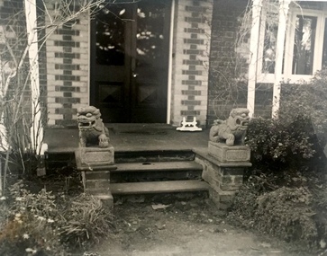
Photograph, Guardian Lions, 'Roseneath', Pakington Street, c.1959
This work forms part of the collection assembled by the historian Dorothy Rogers, that was donated to the Kew Historical Society by her son John Rogers in 2015. The manuscripts, photographs, maps, and documents were sourced by her from both family and local collections or produced as references for her print publications. Many were directly used by Rogers in writing ‘Lovely Old Homes of Kew’ (1961) and 'A History of Kew' (1973), or the numerous articles on local history that she produced for suburban newspapers. Most of the photographs in the collection include detailed annotations in her hand.The Rogers Collection provides a comprehensive insight into the working habits of a historian in the 1960s and 1970s. Together it forms the largest privately-donated collection within the archives of the Kew Historical Society.Small black and white photograph of the guardian lions at the entrance to Roseneath in Pakington Street, Kew."Chinese lions at Roseneath"roseneath -- pakington street -- kew (vic.), historic houses -- kew (vic.) -
 Kew Historical Society Inc
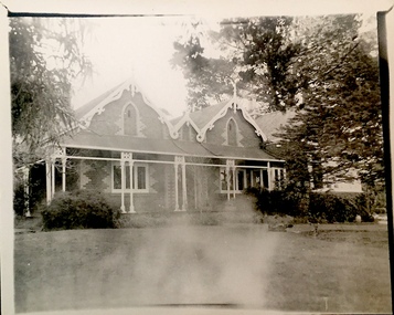
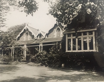
Photograph, 'Roseneath', Pakington Street, c.1959
This work forms part of the collection assembled by the historian Dorothy Rogers, that was donated to the Kew Historical Society by her son John Rogers in 2015. The manuscripts, photographs, maps, and documents were sourced by her from both family and local collections or produced as references for her print publications. Many were directly used by Rogers in writing ‘Lovely Old Homes of Kew’ (1961) and 'A History of Kew' (1973), or the numerous articles on local history that she produced for suburban newspapers. Most of the photographs in the collection include detailed annotations in her hand.The Rogers Collection provides a comprehensive insight into the working habits of a historian in the 1960s and 1970s. Together it forms the largest privately-donated collection within the archives of the Kew Historical Society.Small black and white faded photograph of Roseneath in Pakington Street, Kew."15"roseneath -- pakington street -- kew (vic.), historic houses -- kew (vic.) -
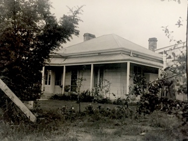
 Kew Historical Society Inc
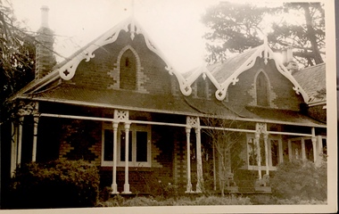
Photograph, 'Roseneath', Pakington Street, c.1959
This work forms part of the collection assembled by the historian Dorothy Rogers, that was donated to the Kew Historical Society by her son John Rogers in 2015. The manuscripts, photographs, maps, and documents were sourced by her from both family and local collections or produced as references for her print publications. Many were directly used by Rogers in writing ‘Lovely Old Homes of Kew’ (1961) and 'A History of Kew' (1973), or the numerous articles on local history that she produced for suburban newspapers. Most of the photographs in the collection include detailed annotations in her hand.The Rogers Collection provides a comprehensive insight into the working habits of a historian in the 1960s and 1970s. Together it forms the largest privately-donated collection within the archives of the Kew Historical Society.Small black and white faded photograph of Roseneath in Pakington Street, Kew."14"roseneath -- pakington street -- kew (vic.), historic houses -- kew (vic.) -
 Kew Historical Society Inc
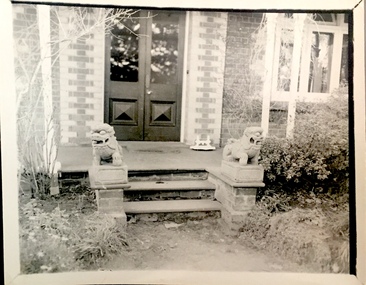
Photograph, Guardian Lions, 'Roseneath', Pakington Street, c.1959
This work forms part of the collection assembled by the historian Dorothy Rogers, that was donated to the Kew Historical Society by her son John Rogers in 2015. The manuscripts, photographs, maps, and documents were sourced by her from both family and local collections or produced as references for her print publications. Many were directly used by Rogers in writing ‘Lovely Old Homes of Kew’ (1961) and 'A History of Kew' (1973), or the numerous articles on local history that she produced for suburban newspapers. Most of the photographs in the collection include detailed annotations in her hand.The Rogers Collection provides a comprehensive insight into the working habits of a historian in the 1960s and 1970s. Together it forms the largest privately-donated collection within the archives of the Kew Historical Society.Small black and white photograph of the guardian lions at the entrance to Roseneath in Pakington Street, Kew."26"roseneath -- pakington street -- kew (vic.), historic houses -- kew (vic.) -
 Kew Historical Society Inc
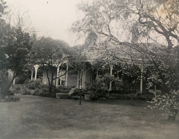
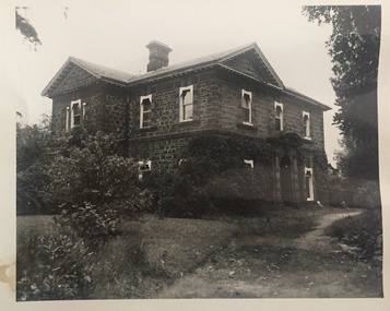
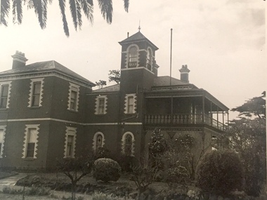
Photograph, 'Campion Hall', Studley Park Road, c.1960
This work forms part of the collection assembled by the historian Dorothy Rogers, that was donated to the Kew Historical Society by her son John Rogers in 2015. The manuscripts, photographs, maps, and documents were sourced by her from both family and local collections or produced as references for her print publications. Many were directly used by Rogers in writing ‘Lovely Old Homes of Kew’ (1961) and 'A History of Kew' (1973), or the numerous articles on local history that she produced for suburban newspapers. Most of the photographs in the collection include detailed annotations in her hand.The Rogers Collection provides a comprehensive insight into the working habits of a historian in the 1960s and 1970s. Together it forms the largest privately-donated collection within the archives of the Kew Historical Society.Small black and white photograph of 'Campion Hall' (previously called Dalswraith and Glendalough) in Studley Park Road, Kew."Ca. 1905 / Campion College / built for S.W. Gibson"historic houses -- kew (vic.), campion hall -- house, glendalough, dalswraith-- dalsraith, kew mansions -
 Kew Historical Society Inc
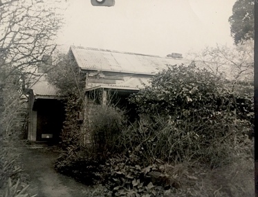
Photograph, Stables, 'Roseneath', Pakington Street, c.1960
This work forms part of the collection assembled by the historian Dorothy Rogers, that was donated to the Kew Historical Society by her son John Rogers in 2015. The manuscripts, photographs, maps, and documents were sourced by her from both family and local collections or produced as references for her print publications. Many were directly used by Rogers in writing ‘Lovely Old Homes of Kew’ (1961) and 'A History of Kew' (1973), or the numerous articles on local history that she produced for suburban newspapers. Most of the photographs in the collection include detailed annotations in her hand.The Rogers Collection provides a comprehensive insight into the working habits of a historian in the 1960s and 1970s. Together it forms the largest privately-donated collection within the archives of the Kew Historical Society.Small black and white photograph of the stables at the rear of Roseneath in Pakington Street, Kew."33"historic houses -- kew (vic.), roseneath -- pakington street -- kew (vic.) -
 Kew Historical Society Inc
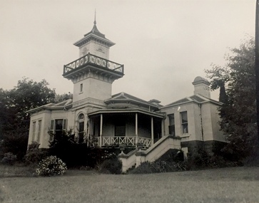
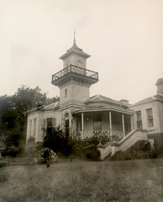
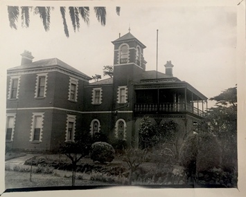
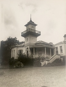
Photograph, 'Ramornie', Pakington Street, c.1960
This work forms part of the collection assembled by the historian Dorothy Rogers, that was donated to the Kew Historical Society by her son John Rogers in 2015. The manuscripts, photographs, maps, and documents were sourced by her from both family and local collections or produced as references for her print publications. Many were directly used by Rogers in writing ‘Lovely Old Homes of Kew’ (1961) and 'A History of Kew' (1973), or the numerous articles on local history that she produced for suburban newspapers. Most of the photographs in the collection include detailed annotations in her hand.The Rogers Collection provides a comprehensive insight into the working habits of a historian in the 1960s and 1970s. Together it forms the largest privately-donated collection within the archives of the Kew Historical Society.Small black and white photograph of the tower and verandas of Ramornie in Pakington Street, Kew.."Commenced 1890 by J.M. Campbell / Ramornie now The Towers / 18"historic houses -- kew (vic.), ramornie -- pakington street -- kew (vic.), the towers -- pakington street -- kew (vic), james maitland campbell -
 Kew Historical Society Inc
Photograph, J E & B L Rogers, 'Turinville', Barnard Grove, c.1960
This work forms part of the collection assembled by the historian Dorothy Rogers, that was donated to the Kew Historical Society by her son John Rogers in 2015. The manuscripts, photographs, maps, and documents were sourced by her from both family and local collections or produced as references for her print publications. Many were directly used by Rogers in writing ‘Lovely Old Homes of Kew’ (1961) and 'A History of Kew' (1973), or the numerous articles on local history that she produced for suburban newspapers. Most of the photographs in the collection include detailed annotations in her hand.The Rogers Collection provides a comprehensive insight into the working habits of a historian in the 1960s and 1970s. Together it forms the largest privately-donated collection within the archives of the Kew Historical Society.Small black and white photograph of the verandas of Turinville, Barnard Grove, Kew."Turinville, ca. 1846. / Built for J. W. Cowell / (1st house in Kew)"historic houses -- kew (vic.), j w cowell, turinville -- barnard grove -- kew (vic.) -
 Kew Historical Society Inc
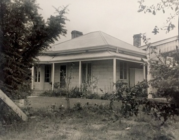
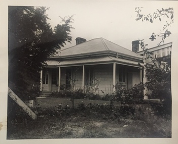
Photograph, 'Otira', Walpole Street, c.1960
This work forms part of the collection assembled by the historian Dorothy Rogers, that was donated to the Kew Historical Society by her son John Rogers in 2015. The manuscripts, photographs, maps, and documents were sourced by her from both family and local collections or produced as references for her print publications. Many were directly used by Rogers in writing ‘Lovely Old Homes of Kew’ (1961) and 'A History of Kew' (1973), or the numerous articles on local history that she produced for suburban newspapers. Most of the photographs in the collection include detailed annotations in her hand.The Rogers Collection provides a comprehensive insight into the working habits of a historian in the 1960s and 1970s. Together it forms the largest privately-donated collection within the archives of the Kew Historical Society.Small black and white photograph of Otira in Walpole Street, Kew."Otira commenced 1887 by Henry Berry / 15"historic houses -- kew (vic.), henry berry, otira -- walpole street -- kew (vic.) -
 Kew Historical Society Inc
Photograph, 'Otira', Walpole Street, c.1960
This work forms part of the collection assembled by the historian Dorothy Rogers, that was donated to the Kew Historical Society by her son John Rogers in 2015. The manuscripts, photographs, maps, and documents were sourced by her from both family and local collections or produced as references for her print publications. Many were directly used by Rogers in writing ‘Lovely Old Homes of Kew’ (1961) and 'A History of Kew' (1973), or the numerous articles on local history that she produced for suburban newspapers. Most of the photographs in the collection include detailed annotations in her hand.The Rogers Collection provides a comprehensive insight into the working habits of a historian in the 1960s and 1970s. Together it forms the largest privately-donated collection within the archives of the Kew Historical Society.Small black and white photograph of Otira in Walpole Street, Kew."Otira Henry Berry / commenced 1887 / 2 of this house"historic houses -- kew (vic.), henry berry, otira -- walpole street -- kew (vic.) -
 Kew Historical Society Inc
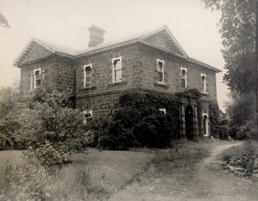
Photograph, 'D'Estaville', 7 Barry Street, c.1960
This work forms part of the collection assembled by the historian Dorothy Rogers, that was donated to the Kew Historical Society by her son John Rogers in 2015. The manuscripts, photographs, maps, and documents were sourced by her from both family and local collections or produced as references for her print publications. Many were directly used by Rogers in writing ‘Lovely Old Homes of Kew’ (1961) and 'A History of Kew' (1973), or the numerous articles on local history that she produced for suburban newspapers. Most of the photographs in the collection include detailed annotations in her hand.The Rogers Collection provides a comprehensive insight into the working habits of a historian in the 1960s and 1970s. Together it forms the largest privately-donated collection within the archives of the Kew Historical Society.Small black and white photograph of 'D'Estaville', 7 Barry Street, Kew."D'Estaville"historic houses -- kew (vic.), d'estaville --- 7 barry street -- kew (vic), sir william stawell -
 Kew Historical Society Inc
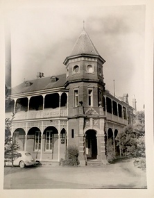
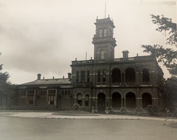
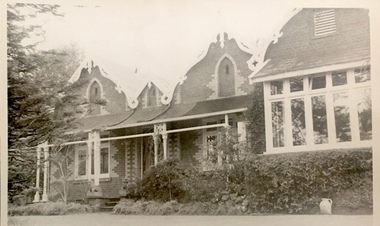
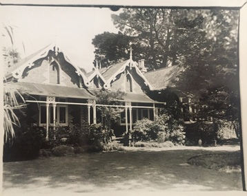
Photograph, 'Raheen', Studley Park Road, c.1960
This work forms part of the collection assembled by the historian Dorothy Rogers, that was donated to the Kew Historical Society by her son John Rogers in 2015. The manuscripts, photographs, maps, and documents were sourced by her from both family and local collections or produced as references for her print publications. Many were directly used by Rogers in writing ‘Lovely Old Homes of Kew’ (1961) and 'A History of Kew' (1973), or the numerous articles on local history that she produced for suburban newspapers. Most of the photographs in the collection include detailed annotations in her hand.The Rogers Collection provides a comprehensive insight into the working habits of a historian in the 1960s and 1970s. Together it forms the largest privately-donated collection within the archives of the Kew Historical Society.Small black and white photograph of 'Raheen', in Studley Park Road, Kew."Raheen by Ed. Latham / (Palace of Roman Catholic Archbishop / 18 / 2 views - either one"historic houses -- kew (vic.), edward latham, raheen -
 Kew Historical Society Inc
Photograph, 'Swinton', Swinton Avenue, c.1960
This work forms part of the collection assembled by the historian Dorothy Rogers, that was donated to the Kew Historical Society by her son John Rogers in 2015. The manuscripts, photographs, maps, and documents were sourced by her from both family and local collections or produced as references for her print publications. Many were directly used by Rogers in writing ‘Lovely Old Homes of Kew’ (1961) and 'A History of Kew' (1973), or the numerous articles on local history that she produced for suburban newspapers. Most of the photographs in the collection include detailed annotations in her hand.The Rogers Collection provides a comprehensive insight into the working habits of a historian in the 1960s and 1970s. Together it forms the largest privately-donated collection within the archives of the Kew Historical Society.Small black and white photograph of 'Swinton' in Swinton Avenue, Kew."Swinton. Ca. 1859 / Built for Edmund Lskey Splatt / 16"historic houses -- kew (vic.), edmund laskey splatt, swinton -
 Kew Historical Society Inc
Photograph, 'Rangeview', Mary Street, c.1960
This work forms part of the collection assembled by the historian Dorothy Rogers, that was donated to the Kew Historical Society by her son John Rogers in 2015. The manuscripts, photographs, maps, and documents were sourced by her from both family and local collections or produced as references for her print publications. Many were directly used by Rogers in writing ‘Lovely Old Homes of Kew’ (1961) and 'A History of Kew' (1973), or the numerous articles on local history that she produced for suburban newspapers. Most of the photographs in the collection include detailed annotations in her hand.The Rogers Collection provides a comprehensive insight into the working habits of a historian in the 1960s and 1970s. Together it forms the largest privately-donated collection within the archives of the Kew Historical Society.Small black and white photograph of 'Rangeview' in Mary Street, Kew."Rangeview. Chapter 52. Commenced about 1880. Now altered to Baptist Hostel"historic houses -- kew (vic.), rangeview -- mary street -- kew (vic.) -
 Kew Historical Society Inc
Photograph, 'Houghton', Princess Street, c.1960
This work forms part of the collection assembled by the historian Dorothy Rogers, that was donated to the Kew Historical Society by her son John Rogers in 2015. The manuscripts, photographs, maps, and documents were sourced by her from both family and local collections or produced as references for her print publications. Many were directly used by Rogers in writing ‘Lovely Old Homes of Kew’ (1961) and 'A History of Kew' (1973), or the numerous articles on local history that she produced for suburban newspapers. Most of the photographs in the collection include detailed annotations in her hand.The Rogers Collection provides a comprehensive insight into the working habits of a historian in the 1960s and 1970s. Together it forms the largest privately-donated collection within the archives of the Kew Historical Society.Small black and white photograph of 'Houghton' (now demolished) in Princess Street, Kew."Houghton. ca. 1860 / 17"historic houses -- kew (vic.), houghton -- princess street -- kew (vic.) -
 Kew Historical Society Inc
Photograph, 'D'Estaville', 7 Barry Street, c.1960
This work forms part of the collection assembled by the historian Dorothy Rogers, that was donated to the Kew Historical Society by her son John Rogers in 2015. The manuscripts, photographs, maps, and documents were sourced by her from both family and local collections or produced as references for her print publications. Many were directly used by Rogers in writing ‘Lovely Old Homes of Kew’ (1961) and 'A History of Kew' (1973), or the numerous articles on local history that she produced for suburban newspapers. Most of the photographs in the collection include detailed annotations in her hand.The Rogers Collection provides a comprehensive insight into the working habits of a historian in the 1960s and 1970s. Together it forms the largest privately-donated collection within the archives of the Kew Historical Society.Small black and white photograph of 'D'Estaville', 7 Barry Street, Kew."D'Estaville / built 1857 for Sir Wm Foster Stawell"historic houses -- kew (vic.), d'estaville -- 7 barry street -- kew (vic.), sir william foster stawell -
 Kew Historical Society Inc
Photograph, 'Houghton', Princess Street, c.1960
This work forms part of the collection assembled by the historian Dorothy Rogers, that was donated to the Kew Historical Society by her son John Rogers in 2015. The manuscripts, photographs, maps, and documents were sourced by her from both family and local collections or produced as references for her print publications. Many were directly used by Rogers in writing ‘Lovely Old Homes of Kew’ (1961) and 'A History of Kew' (1973), or the numerous articles on local history that she produced for suburban newspapers. Most of the photographs in the collection include detailed annotations in her hand.The Rogers Collection provides a comprehensive insight into the working habits of a historian in the 1960s and 1970s. Together it forms the largest privately-donated collection within the archives of the Kew Historical Society.Small black and white photograph of 'Houghton (demolished)', Princess Street, Kew."Houghton"historic houses -- kew (vic.), houghton -- princess street -- kew (vic.) -
 Kew Historical Society Inc
Photograph, 'Houghton', Princess Street, c.1960
This work forms part of the collection assembled by the historian Dorothy Rogers, that was donated to the Kew Historical Society by her son John Rogers in 2015. The manuscripts, photographs, maps, and documents were sourced by her from both family and local collections or produced as references for her print publications. Many were directly used by Rogers in writing ‘Lovely Old Homes of Kew’ (1961) and 'A History of Kew' (1973), or the numerous articles on local history that she produced for suburban newspapers. Most of the photographs in the collection include detailed annotations in her hand.The Rogers Collection provides a comprehensive insight into the working habits of a historian in the 1960s and 1970s. Together it forms the largest privately-donated collection within the archives of the Kew Historical Society.Small black and white photograph of 'Houghton (demolished)', Princess Street, Kew.historic houses -- kew (vic.), houghton -- princess street -- kew (vic.) -
 Kew Historical Society Inc
Photograph, 'Swinton', Swinton Avenue, c.1960
This work forms part of the collection assembled by the historian Dorothy Rogers, that was donated to the Kew Historical Society by her son John Rogers in 2015. The manuscripts, photographs, maps, and documents were sourced by her from both family and local collections or produced as references for her print publications. Many were directly used by Rogers in writing ‘Lovely Old Homes of Kew’ (1961) and 'A History of Kew' (1973), or the numerous articles on local history that she produced for suburban newspapers. Most of the photographs in the collection include detailed annotations in her hand.The Rogers Collection provides a comprehensive insight into the working habits of a historian in the 1960s and 1970s. Together it forms the largest privately-donated collection within the archives of the Kew Historical Society.Small black and white photograph of 'Swinton', Swinton Avenue, Kew.historic houses -- kew (vic.), swinton -- swinton avenue -- kew (vic.) -
 Kew Historical Society Inc
Photograph, 'Villa Alba', Walmer Street, c.1960
This work forms part of the collection assembled by the historian Dorothy Rogers, that was donated to the Kew Historical Society by her son John Rogers in 2015. The manuscripts, photographs, maps, and documents were sourced by her from both family and local collections or produced as references for her print publications. Many were directly used by Rogers in writing ‘Lovely Old Homes of Kew’ (1961) and 'A History of Kew' (1973), or the numerous articles on local history that she produced for suburban newspapers. Most of the photographs in the collection include detailed annotations in her hand.The Rogers Collection provides a comprehensive insight into the working habits of a historian in the 1960s and 1970s. Together it forms the largest privately-donated collection within the archives of the Kew Historical Society.Small black and white photograph of 'Villa Alba', Walmer Street, Kew.historic houses -- kew (vic.), villa alba -- walmer street -- kew (vic.) -
 Kew Historical Society Inc
Photograph, 'Rangeview', Mary Street, c.1960
This work forms part of the collection assembled by the historian Dorothy Rogers, that was donated to the Kew Historical Society by her son John Rogers in 2015. The manuscripts, photographs, maps, and documents were sourced by her from both family and local collections or produced as references for her print publications. Many were directly used by Rogers in writing ‘Lovely Old Homes of Kew’ (1961) and 'A History of Kew' (1973), or the numerous articles on local history that she produced for suburban newspapers. Most of the photographs in the collection include detailed annotations in her hand.The Rogers Collection provides a comprehensive insight into the working habits of a historian in the 1960s and 1970s. Together it forms the largest privately-donated collection within the archives of the Kew Historical Society.Small black and white photograph of 'Rangeview', Mary Street, Kew."RANGEVIEW"historic houses -- kew (vic.), rangeview -- mary street -- kew (vic.) -
 Kew Historical Society Inc
Photograph, 'Rangeview', Mary Street, c.1960
This work forms part of the collection assembled by the historian Dorothy Rogers, that was donated to the Kew Historical Society by her son John Rogers in 2015. The manuscripts, photographs, maps, and documents were sourced by her from both family and local collections or produced as references for her print publications. Many were directly used by Rogers in writing ‘Lovely Old Homes of Kew’ (1961) and 'A History of Kew' (1973), or the numerous articles on local history that she produced for suburban newspapers. Most of the photographs in the collection include detailed annotations in her hand.The Rogers Collection provides a comprehensive insight into the working habits of a historian in the 1960s and 1970s. Together it forms the largest privately-donated collection within the archives of the Kew Historical Society.Small black and white photograph of 'Rangeview', Mary Street, Kew."2"historic houses -- kew (vic.), rangeview -- mary street -- kew (vic.) -
 Kew Historical Society Inc
Photograph, 'Campion Hall', Studley Park Road, c.1960
This work forms part of the collection assembled by the historian Dorothy Rogers, that was donated to the Kew Historical Society by her son John Rogers in 2015. The manuscripts, photographs, maps, and documents were sourced by her from both family and local collections or produced as references for her print publications. Many were directly used by Rogers in writing ‘Lovely Old Homes of Kew’ (1961) and 'A History of Kew' (1973), or the numerous articles on local history that she produced for suburban newspapers. Most of the photographs in the collection include detailed annotations in her hand.The Rogers Collection provides a comprehensive insight into the working habits of a historian in the 1960s and 1970s. Together it forms the largest privately-donated collection within the archives of the Kew Historical Society.Small black and white photograph of 'Campion Hall' (also known as Dalsraith, Dalswraith, Glendalough) in Studley Park Road, Kew."17"historic houses -- kew (vic.), campion house -- campion hall, dalsraith -- dalswraith, glendalough, mansions -- studley park road -- kew (vic), ussher and kemp -
 Kew Historical Society Inc
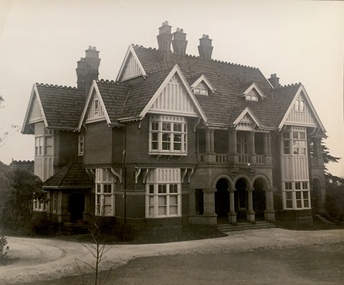
Photograph, 'Roseneath', Pakington Street, c.1960
This work forms part of the collection assembled by the historian Dorothy Rogers, that was donated to the Kew Historical Society by her son John Rogers in 2015. The manuscripts, photographs, maps, and documents were sourced by her from both family and local collections or produced as references for her print publications. Many were directly used by Rogers in writing ‘Lovely Old Homes of Kew’ (1961) and 'A History of Kew' (1973), or the numerous articles on local history that she produced for suburban newspapers. Most of the photographs in the collection include detailed annotations in her hand.The Rogers Collection provides a comprehensive insight into the working habits of a historian in the 1960s and 1970s. Together it forms the largest privately-donated collection within the archives of the Kew Historical Society.Small black and white photograph of 'Roseneath' in Pakington Street, Kew."34"historic houses -- kew (vic.), roseneath -- pakington street -- kew (vic.) -
 Kew Historical Society Inc
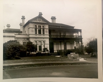
Photograph, 'Roseneath', Pakington Street, c.1960
This work forms part of the collection assembled by the historian Dorothy Rogers, that was donated to the Kew Historical Society by her son John Rogers in 2015. The manuscripts, photographs, maps, and documents were sourced by her from both family and local collections or produced as references for her print publications. Many were directly used by Rogers in writing ‘Lovely Old Homes of Kew’ (1961) and 'A History of Kew' (1973), or the numerous articles on local history that she produced for suburban newspapers. Most of the photographs in the collection include detailed annotations in her hand.The Rogers Collection provides a comprehensive insight into the working habits of a historian in the 1960s and 1970s. Together it forms the largest privately-donated collection within the archives of the Kew Historical Society.Small black and white photograph of 'Roseneath' in Pakington Street, Kew."Roseneath - C. 1858. North wing built by E.J. Dunn / 2 of this house print either one"historic houses -- kew (vic.), roseneath -- pakington street -- kew (vic.) -
 Kew Historical Society Inc
Photograph - 'Reno', St John's Parade, c.1960
This work forms part of the collection assembled by the historian Dorothy Rogers, that was donated to the Kew Historical Society by her son John Rogers in 2015. The manuscripts, photographs, maps, and documents were sourced by her from both family and local collections or produced as references for her print publications. Many were directly used by Rogers in writing ‘Lovely Old Homes of Kew’ (1961) and 'A History of Kew' (1973), or the numerous articles on local history that she produced for suburban newspapers. Most of the photographs in the collection include detailed annotations in her hand.The Rogers Collection provides a comprehensive insight into the working habits of a historian in the 1960s and 1970s. Together it forms the largest privately-donated collection within the archives of the Kew Historical Society.Small black and white photograph of 'Reno' (demolished 1977), St John's Parade, Kew."Reno / 3"historic houses -- kew (vic.), reno -- st john's parade -- kew (vic.) -
 Kew Historical Society Inc
Photograph - 'Reno', St John's Parade, c.1960
This work forms part of the collection assembled by the historian Dorothy Rogers, that was donated to the Kew Historical Society by her son John Rogers in 2015. The manuscripts, photographs, maps, and documents were sourced by her from both family and local collections or produced as references for her print publications. Many were directly used by Rogers in writing ‘Lovely Old Homes of Kew’ (1961) and 'A History of Kew' (1973), or the numerous articles on local history that she produced for suburban newspapers. Most of the photographs in the collection include detailed annotations in her hand.The Rogers Collection provides a comprehensive insight into the working habits of a historian in the 1960s and 1970s. Together it forms the largest privately-donated collection within the archives of the Kew Historical Society.Small black and white photograph of 'Reno' (demolished 1977), St John's Parade, Kew."49"historic houses -- kew (vic.), reno -- st john's parade -- kew (vic.) -
 Kew Historical Society Inc
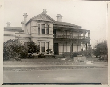
Photograph, 'Roseneath', Pakington Street, c.1960
This work forms part of the collection assembled by the historian Dorothy Rogers, that was donated to the Kew Historical Society by her son John Rogers in 2015. The manuscripts, photographs, maps, and documents were sourced by her from both family and local collections or produced as references for her print publications. Many were directly used by Rogers in writing ‘Lovely Old Homes of Kew’ (1961) and 'A History of Kew' (1973), or the numerous articles on local history that she produced for suburban newspapers. Most of the photographs in the collection include detailed annotations in her hand.The Rogers Collection provides a comprehensive insight into the working habits of a historian in the 1960s and 1970s. Together it forms the largest privately-donated collection within the archives of the Kew Historical Society.Small black and white photograph of 'Roseneath', Pakington Street, Kew."Roseneath. Ca.1858. North Wing added by E.J. Dunn"historic houses -- kew (vic.), roseneath -- pakington street -- kew(vic.) -
 Kew Historical Society Inc
Photograph, J E & B L Rogers, 'Swinton', Swinton Avenue, c.1959
This work forms part of the collection assembled by the historian Dorothy Rogers, that was donated to the Kew Historical Society by her son John Rogers in 2015. The manuscripts, photographs, maps, and documents were sourced by her from both family and local collections or produced as references for her print publications. Many were directly used by Rogers in writing ‘Lovely Old Homes of Kew’ (1961) and 'A History of Kew' (1973), or the numerous articles on local history that she produced for suburban newspapers. Most of the photographs in the collection include detailed annotations in her hand.The Rogers Collection provides a comprehensive insight into the working habits of a historian in the 1960s and 1970s. Together it forms the largest privately-donated collection within the archives of the Kew Historical Society.Small black and white photograph of 'Swinton', Swinton Avenue, Kew"SWINTON"swinton -- swinton avenue -- kew (vic.), historic houses -- kew (vic.) -
 Port Fairy Historical Society Museum and Archives
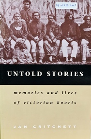
Book, Melbourne University Press, Untold stories : memories and lives of Victorian Kooris, 1998
'I'm your half-brother and I'm here to stay. This is my home.' With these words Wilmot Abraham sought refuge with his white relations. 'Did you ever read your history?': Mrs. Mary Clarke remembers p. 1 'An old hand': Jim Cain p. 12 'I'm your half-brother, and I'm here to stay': Wilmot Abraham p. 36 The Three Pompeys The Written Record p. 48 Banjo Clarke's Stories p. 62 'Why did they take them away?': Lizzie and Henry McCrae p. 74 In Defence of Framlingham: Collin Hood p. 79 Double Dispossession: King David p. 107 James Dawson's Informants p. 137 'Why are we kept prisoners here?': Ernest and Maggie Mobourne p. 148 'The old ones, they wouldn't tell us nothing': Mrs. Connie Hart's memories p. 181 'Breaking the cycle is the hard thing to do': Geoff Rose, a stolen child p. 200 Epilogue: James Dawson, Camperdown George and the Obelisk p. 220 The Hood Family p. 238 The Mobourne Letters p. 241 Abbreviations p. 252 Notes p. 252 Bibliography p. 264 Index p. 274xxi, 283 p. : ill., facsims., map, ports. ; 23 cm. Includes index and bibliographical references: p. 264-273.non-fiction'I'm your half-brother and I'm here to stay. This is my home.' With these words Wilmot Abraham sought refuge with his white relations. 'Did you ever read your history?': Mrs. Mary Clarke remembers p. 1 'An old hand': Jim Cain p. 12 'I'm your half-brother, and I'm here to stay': Wilmot Abraham p. 36 The Three Pompeys The Written Record p. 48 Banjo Clarke's Stories p. 62 'Why did they take them away?': Lizzie and Henry McCrae p. 74 In Defence of Framlingham: Collin Hood p. 79 Double Dispossession: King David p. 107 James Dawson's Informants p. 137 'Why are we kept prisoners here?': Ernest and Maggie Mobourne p. 148 'The old ones, they wouldn't tell us nothing': Mrs. Connie Hart's memories p. 181 'Breaking the cycle is the hard thing to do': Geoff Rose, a stolen child p. 200 Epilogue: James Dawson, Camperdown George and the Obelisk p. 220 The Hood Family p. 238 The Mobourne Letters p. 241 Abbreviations p. 252 Notes p. 252 Bibliography p. 264 Index p. 274 western district (vic.) -- colonization., aboriginal australians -- victoria -- western district -- history., aboriginal australians -- victoria -- western district -- interviews, race relations - racial discrimination., child welfare - child / parent separation - stolen generations., history - biographies - indigenous., book