Showing 981 items
matching paddocks
-
 Stawell Historical Society Inc
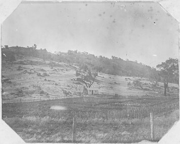
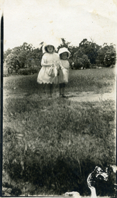
Photograph, Man standing in paddock in front of Hut with hill behind believed to be the Sugarloaf -- Probably the McKay's property owned by McKay's
Man standing in paddock in front of Hut with hill behind believed to be the Sugarloaf. Probably the McKay's property owned by McKay's (2011). Originally part of Allanvale owned by the Bowtell Family. Located at the end of Graces Hill Road and continuation of Panrock Reservoir Road Extension. stawell -
 Eltham District Historical Society Inc
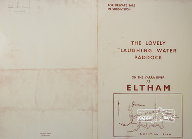
Photograph, For Private Sale in Subdivisions; The Lovely "Laughing Water" Paddock on the Yarra River at Eltham
Private sale of the "Laughing Water" paddock in subdivision; 5 river frontages with weatherboard villa on Lot 8; 6 woodland blocks of 5 and 6 acres. Sole Agent: Edward Haughton, 379 Collins Street, Melbourne Location plan and subdivision mapA3 colour photographic print from digital image of sales brochure and A4 reproduction of price listlaughing waters, edward haughton, real estate agent, eltham -
 Tatura Irrigation & Wartime Camps Museum
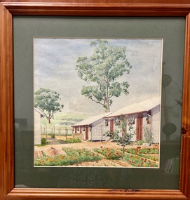
Painting - Painting - Water Colour, Lagerbild Germalt von Glunkler
The painting is of Camp 3 painted by internee Glunkler.Water colour of two huts with the windows open. Another hut is partially in the picture. An item of washing is hanging on a clothes line between two of the huts. A garden of red flowers in is the foreground and two gum tree are in the paddock behind a wire fence. Wooden frame behind glass with dark green matt.Glunkler 1942 -
 Glenelg Shire Council Cultural Collection
Photograph - Photograph - Bridge, n.d
Sourced from Casterton Town Hall (former Shire of Glenelg)Coloured photograph. Same as 7302 7302 - Coloured photograph. Unmade road between paddocks. Photo taken close to bridge with wooden railings. Erosion of creek sides can be seen. Sign at bridge ' Bridge Load Limit 5 t gross'? Same bridge as 7301, taken at different time. -
 Eltham District Historical Society Inc
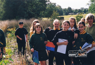
Photograph, Richard Pinn, Tree Planting, Hurstbridge Primary School students, Fergusons Paddock, Hurstbridge, c.1999, 1999c
The woman in the light green top is Martina Neale, who was the driving force behind a group of volunteers who revegetated a part of Fergusons Paddock. On this occasion, most of the work was done by students from Hurstbridge Primary School, as part of a program promoting interaction with the wider community.Colour photographhurstbridge primary school, fergusons paddock, martina neale -
 Surrey Hills Historical Society Collection
Photograph, Streetscape near the corner of Victoria Crescent and Hotham Street, Surrey Hills
Prior to subdivision for housing this area was paddocks used for grazing of cattle and used as part of the course in the early days of the Surrey Hills Golf Club. Reproduced by permission of Mr John Arnold from his book: "The Riversdale Golf Club - a history, 1892-1977." Copyright to book: Riversdale Golf Club. Surrey Hills Golf Club operated from 1892-1908 then moved and became Riversdale Golf Club. The game was played across paddocks from Trafalgar Street, Mont Albert to Whitehorse Road and down Victoria Crescent to where Box Hill TAFE is now located in Elgar Road. There were problems with cows eating the tee flags! The clubhouse still exists as 30 Trafalgar Street.Black and white photo taken from the centre of a bitumen road which is flanked by bluestone guttering. Nature strips, drive cross-overs and house fences are shown. Trees on the RHS nature strip are pollarded to avoid overhead power and telephone lines. There houses in the background."Bottom: The same view today taken from the intersection of Victoria Crescent and Hotham Street, Surrey Hills."surrey hills golf club, hotham street, victoria crescent, riversdale golf club, surrey hills, john arnold -
 Federation University Historical Collection
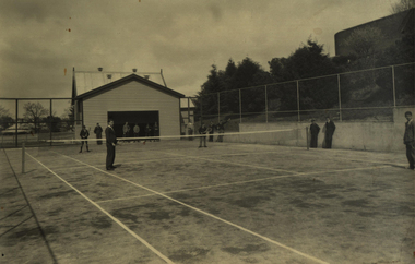
Photograph - Photograph - Black and White, Richards & Co, Ballarat Junior Technical School Tennis Court - 1956, 1956
When Ballarat Junior Technical School building was opened in 1921, there was little cleared space for the students to use for sporting activities. The area known as Battery Paddock was used for dodge-ball and football. Gradually the slope area was cleared and planted. In November 1922 a tennis court was opened in the Battery Paddock. It was designed and built by two former students of the Ballarat School of Mines. The old Mount Doran school house was moved to the area as a students' common room. A new tennis court was built in the same vicinity in 1934. This area was on the corner of Grant and Albert Streets. Area is where the Corbould Building and the Automotive Skills Centre of School of Mines Ballarat Grant Street Campus now stand. Black and white photograph of the tennis court built in 1934 at Ballarat Junior Technical School. Gaol wall to the left and the old Mount Doran school house that was moved to the school grounds in 1922 and used as a Students' common room. Four students playing tennis with others watching.Stamp on back indicating photographer - "Richards & Co - Ballarat"ballarat junior technical school, student, 1921, battery paddock, ballarat school of mines, ballarat school of mines tennis court, mount doran, students' common room, 1934, grant street, albert street, corbould building, automotive skills centre, student activities -
 National Wool Museum
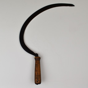
Tool - Sickle, Pre. 1988
Feed for sheep farming is crucially important. Whether growing a sheep for breeding, wool or meat, it is vital to ensure that all sheep at whatever stage of life are maintaining or growing in weight. Sheep are often pictured grazing in paddocks; however, the grass available in a paddock is often not enough to maintain a sheep’s weight. In addition, if a sheep eats grass too low in a paddock then corrosion can affect the soil preventing any grass from growing in this location. For these reasons, supplementary feed is introduced to sheep’s diets. In most occasions’ food high in protein such as Lupins is sought. In times such as drought or to makeup a sheep’s roughage; feed such as silage, hay and straw may be required in the feeding of sheep. This is where the sickle is introduced to sheep farming. Although modern-day machines are used to harvest cereals, in times past the sickle was used for harvesting these crops. Once harvested, these crops can be fed to sheep freshly cut or dried. This sickle has been on display for 30 years at the National Wool Museum. It was at the entrance to Gallery One in the “A New Europe” wood hut display case. It was taken off display in 2021 with the “On the Land” redevelopment of this gallery space.Curved Metal serrated blade extending from carved dark wooden handletools of the trade, sheep feed, sheep farming -
 Orbost & District Historical Society
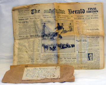
newspaper, Sept 9 1919
This newspaper was sent by the Shire President Cr F. Deery from Bairnsdale to P.C. Cameron, Orbost Shire President. It was sent on the first aeroplane to arrive in Orbost. The Commonwealth plane in the charge of Lieut. Oakes landed in Mr McPhee's paddock at Newmerella. It left for Sale on the same day.The purpose of the plane's visit was to raise subscriptions towards the WW1 peace loan. There is a plaque commemorating the oversubscription to the peace loan by the Shire of Orbost by 1919.A yellowed Herald newspaper from September 9 1919. It has the brown paper packaging in which it was sent. It is tied with string.newspaper document herald-melbourne first-aeroplane-orbost peace-loan -
 Eltham District Historical Society Inc
Negative - Photograph, Merton Hall School class at Greensborough, c.1922
Photo taken at P.A. & E.M. Cooper's front paddock of their weekender at Sherbourne Rd, Greensborough. The drag was pulled by two horses and was hired for the day by Marjorie Cooper's class at Merton Hall. Copy of the original image contained in a photo album belonging to Marjorie North (nee Cooper).Roll of 35mm colour negative film, 1 strip (3 frames) - copy of original photo in private album Colour print of negativeAgfa XRG 200p.a cooper, e.m. cooper, sherbourne road, greensborough, merton hall, horse drawn vehicles, marjorie north, phaeton, school groups -
Glen Eira Historical Society
Document - Dairies
This file contains two items: 1/A handwritten description of Margaret Bullock’s memories of the area where Sheridan’s dairy and house were in Kooyong Road, and of Lempriere’s Paddock. 2/A photocopied extract from Caulfield’s heritage vol. 1 by Dr. Gewlah Solomon on Joseph Sheridan.sheridan, dairies, hospital, car park, sheridan’s paddocks, north road, bluestone, sheridan’s cottage, lempriere estate, white flett, berkley hospital, the little company of mary, bethlehem hospital, bullock margaret, stewart margaret, gardenvale road, kooyong road, sheridan joseph, dairyman, mansions, dairy farms, sheridan t. j., sheridan thomas, elsternwick, dairying -
Glenelg Shire Council Cultural Collection
Photograph - Contact Print - Portland, Victoria, 1970s
Set of 3 pairs of stereoscopic contact prints from glass plate negatives. Top: View from hill overlooking homestead and outbuildings. Middle: paddocks, fence, sheep run. Bottom: View from south side Cliff Street - looking north along Bentinck Street railway cutting to station.portland scene, bentinck street, street scene, photography -
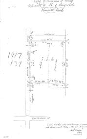 Ringwood and District Historical Society
Document - Copy of Lands Department Field Notes - Parish of Ringwood, Victoria, Field Notes 1917/137 - Part of O.P. R72 - Allotment 10, surveyed June 1917
5613b Foolscap size photocopy of survey map with handwritten notations. References include Knight's land, Wantirna Road, Canterbury Road, house, wirenetted, orchard, grass paddock, I certify that these notes are a true copy of observations and measurements taken on the ground by me (signed) H.W. Moore 5/6/17. -
 Bendigo Historical Society Inc.
Photograph - ROY J MITCHELL COLLECTION: FARM SHED
Colour photograph of dilapidated farm shed near Goornong. Shed appears to be a shelter, open underneath with corrugated iron roof. Trees behind, grass paddock in foreground. Written on back ' 29.3.96 near Goornong vict 14.30 hours, Shepparton-Bendigo Road, near Goornong. By Roy J Mitchell Bendigo.'agriculture, farm, shed -
City of Kingston
Photograph - Black and white, 5 January 1984
Moorabbin, Cheltenham and Highett are suburbs in the City of Kingston with a diverse mix of development and zoning. The market gardens, farms and paddocks have gradually been sub-divided into housing and industrial estates and associated infrastructure such as schools and shopping facilities. The area includes many parks, reserves and golf courses.This aerial image covers a diverse section of the City of Kingston, taking in the suburbs of Cheltenham, Moorabbin, Beaumaris and Highett. By 1984, the market gardens of the district have been replaced by housing and factories. The Gas and Fuel state-of-the-art Scientific Services Department is visible on Nepean Highway Highett. The CSIRO Highett site can also be seen. Both sites have now been demolished and have undergone remediation. The Southland site is visible and yet to be redeveloped by Westfield. This image portrays the diversity of development in the City of Kingston with a mixture of green spaces, housing and commercial and industrial features.Aerial photograph of Cheltenham, Beaumaris, Moorabbin and Highett within the City of Kingston. The area depicted in the 1984 aerial view includes Eden Street and Edward Street, Cheltenham (top left), Weatherall Road and Reserve Road, Cheltenham/Beaumaris (top right), Turner Road and Chesterville Road, Moorabbin (bottom left), Nepean Highway (left section), Graham Road and Middleton Street, Highett (bottom right). A large section of this image includes Cheltenham Park and Victoria Golf Club.White text: 3831-219 Lens information [indecipherable] RINGWOOD M/S 7922-3 RUN 15 Clockface image 5,300' ASL VIC DLS© 5-1-84cheltenham, highett, industrialisation, urbanisation, moorabbin, beaumaris -
Kew Historical Society Inc
Archive (Sub-series) - Subject File, Conservation Study (Kew) 1978, 1978
Various partiesReference, Research, InformationSecondary Values (KHS Imposed Order)Subject file containing a copy of the City of Kew’s Urban Renewal Proposal (13pp), dated June 1978. The proposal to the Urban Renewal Authority relates to those houses in Denmark Street, High Street South and Barkers Road, then known as ‘The Triangle’ (historically known as O’Shaughnessy’s Paddock. The report refers to the Kew Triangle Association.urban renewal -- kew (vic.), conservation studies -- kew (vic.), kew triangle associationurban renewal -- kew (vic.), conservation studies -- kew (vic.), kew triangle association -
City of Kingston
Photograph - Black and white, 17 January 1951
Moorabbin, Cheltenham and Highett are suburbs in the City of Kingston with a diverse mix of development and zoning. This 1954 image shows the market gardens, farms and paddocks of the Moorabbin and Cheltenham area. which have gradually been sub-divided into The Highett Gas Works is visible and Cheltenham Park and Victoria Golf Club.The suburbs of Cheltenham and Moorabbin were originally developed with extensive market gardens. Over time the district has been transformed with the farms and paddocks replaced by housing, factories and shopping centres. The Highett Gas Works on the Nepean Highway was a significant feature of the landscape and has now been demolished. and the site has undergone remediation.Aerial photograph of Cheltenham, Moorabbin and Highett within the City of Kingston. The area depicted in this 1951 aerial view includes Wickham Road, Highett (bottom right), Keys Road, Moorabbin (bottom left), Centre Dandenong Road Cheltenham (top left), Park Road, Cheltenham (top right), Nepean Highway (left section), Graham Road and Middleton Street, Highett (bottom right). Cheltenham Park and Victoria Golf Club are visible. Nepean Highway and the Frankston railway line run centrally through the image.White type: 1416-37 538 RUN239 LENS 5312" MELBOURNE METROPOLITAN 12150 17-1-51 ↆ M539 Black pencil: N [arrow]cheltenham, highett, highett gas works, market gardens -
University of Melbourne, Burnley Campus Archives
Article - Photocopy, Horticultural Society of Victoria, 1860
Photocopy of Newspaper Article, Thursday 2 August, 1860 p 7 Report of the monthly meeting of the HSV Municipal Council of Richmond and commissioner of Public Works had granted funds for fencing the gardens and plans for a special meeting as soon as the Department of Lands had granted them land in the Surrey Paddock.Newspaper article from The Argusthe argus, surrey paddock, burnley gardens, horticultural society of victoria, hsv -
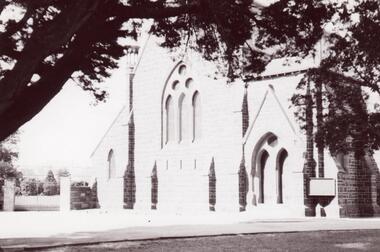 Glen Eira Historical Society
Photograph - St. Mary’s Church, Caulfield
Three photographs and one photocopied photograph of St. Mary’s Anglican Church Caulfield. All are undated and photographers are unknown. The first has paddocks in the foreground with the church in the distance. Also included are three lithographs of an architectural sketch of the proposed church from Illustrated Australian News 1870-1874, page 148.st. mary’s church, caulfield, reed and barnes, architects, caulfield, illustrated australian news -
Glen Eira Historical Society
Document - LEMPRIERE’S PADDOCK
2 items about this location 1/Handwritten (3 pages) and typed duplication (2 pages) of notes on Lempriere’s Paddock and Estate 1902 -1928 by Mary Stewart. She grew up there with recollections including polo and gypsy encampments. 2/Handmade map of Lempriere Estate, subdivided circa 1910.lempriere’s paddock, martin street, ‘lempriere estate’, stewart mary, cole street, gardenia road, polo grounds, gardenvale railway station, north road, nepean road, magnolia road, cochrane street, gardenvale -
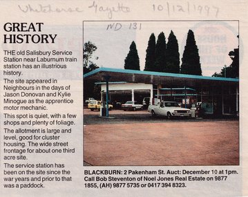 Whitehorse Historical Society Inc.
Article, Great history, 10/12/1997 12:00:00 AM
Cutting from the Whitehorse Gazette, 10/12/1997Cutting from the Whitehorse Gazette, 10/12/1997 regarding the auction of the old Salisbury Service Station near Laburnum Railway station to be conducted on 10 December at 1PM. The service station has been on the site since the war years and prior to that was a paddock. The site appeared in 'Neighbours' in the days of Jason Donovan and Kylie Minogue.Cutting from the Whitehorse Gazette, 10/12/1997salisbury service station, laburnum railway station, donovan, jason, minogue, kylie, steventon, bob, noel jones, auctions -
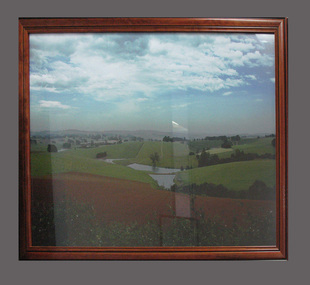 South Gippsland Shire Council
Photograph
Framed colour photograph featuring a landscape showing low hills, ploughed paddock in foreground and dams in centre. Brown timber frame. Note: Item approved for deaccession August 2023. SGSC will now follow deaccession procedures as outlined in the Arts and Civic Memorabilia Collection Policy - https://www.southgippsland.vic.gov.au/downloads/file/2763/arts_and_artefacts_collection_policy_c69. -
 Greensborough Historical Society
Photograph - Digital image, Frank Robinson, Looking west over Pope's paddock to Main Street, 1954_
Looking west over Pope's paddock to Main Street. The Blackjack property, house and acres of fruit orchards ran down to the Plenty River off Hume Street Greensborough and was the home of the Robinson family to late 1956. The photographs were taken as slides by Frank Robinson and digitised by his son James in 2015.Digital copy of colour photograph.popes paddock, main street greensborough, blackjack -
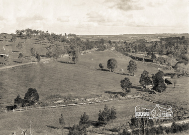 Eltham District Historical Society Inc
Photograph, Pepper's Paddock, Wattle Glen, c.1927, 1927c
Originally dated in pen on reverse as 1920 then crossed out to 1925 but it must be post August 1926 due to presence of an electric train. However no sign of the Sunnyside Estate development (1926?) although most of it could be over the hill out of shot. The furrows suggest that the paddock had been an orchard (probably apple).Digital copy of black and white photographelectric train, hurstbridge railway line, railway line, wattle glen, pepper's paddock -
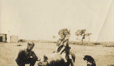 Surrey Hills Historical Society Collection
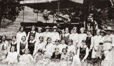
Photograph, Gwen and Beryl Mair with Mr Jarman, Derrinallum, c1927
David Miller (Dave) Mair (1879-1938) married Lily Vipond Deakin (1890-1945) in 1910. They had 5 children: Geoffrey David (1913-1970), Beryl (1916-1976), Gwynneth (1917-1997), Isabel Lillian (1921-1997) and Shirley Inez (1928-1968). Personal communication from Laurie Newton, Beryl's daughter: Dave and Lily initially lived in East Melbourne after they married. Dave walked across the gardens to work at the MCG. He never drove or owned a car. Geoffrey, Beryl and Gwynneth were born in East Melbourne. They subsequently moved to Louise Avenue, Mont Albert and Isabel may have been born while they were there. Later they purchased 20 Barton Street, Mont Albert. Shirley was born after they moved to Barton Street. Electoral roll details: 1919 1922 24 Louise Avenue, Mont Albert 1924 20 Barton Street, Mont Albert Dave Mair was a very keen sportsman. This is part of a large donation of material from the Deakin, Mair and Young families. The Deakin, Mair and Young families had many connections with Mont Albert and Surrey Hills.A sepia photo of 2 girls on the back of a pig, which is being lightly held by a man, squatting beside the animal. A cattle dog sits nearby. In the background are some straggly trees along what may be a boundary or paddock fence, apart from which the surroundings look very bare. Off to the LHS in the background is farm shedding.In black ink: "Off for a joy ride / B. Mair / 20 Barton St / SUrrey Hills / E10." - thought to be in Lily Mair's handwriting. In blue biro: " Gwen Beryl (IN FRONT in lead pencil) / Mr Jarman / Derrinallum" Thought to be Beryl Mair's handwriting. "KODAK PRINT" in black. beryl mair, gwen mair, mr jarman, farms, children, derrinallum -
 Whitehorse Historical Society Inc.
Photograph, Joyce & Elvie Johns, c1924
Black & white photo of Joyce & Elvie Johns, Daughters of Mr. & Mrs. F. Johns of Orient Ave Mitcham. Note the narrow strip of dirt road with grass paddocks on each side. Elvie, born 29 April 1918, married Stan Finger, Orchardist. Joyce born Sept 1920 died 1924 - Scarlett Fever.johns joyce, johns elvie, finger stan, vermont, orient ave 41 -
 Bendigo Historical Society Inc.
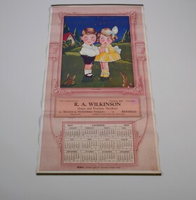
Document - CALENDAR COLLECTION: R. A. WILKINSON
Wall calendar from 1937. Pink and white with a picture of a boy and a girl in a paddock, two rabbits looking at them few tree and a house in the background. At both side of the picture a box of robur tea. With compliments from R. A. Wilkinson grocer and provision merchant crn Mundy and Stenberg Streets, Bendigo. Telephone 1068 - Private 864business, retail, r. a. wilkinson -
 Bendigo Historical Society Inc.
Photograph - HARRY BIGGS COLLECTION: UNKNOWN BUILDINGS
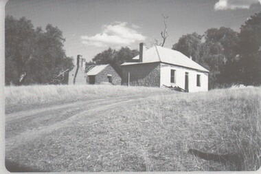
Two Photographs ( proofs 60 and 61). No. 60 Mud brick? or bluestone house with another bluestone building visible in the background, this second building has a large portion of the roof missing. There is also a ruined section of a brick wall, these are set at the top of a rise with a track leading towards them. 61,. Two derelict bluestone? Building standing in a paddock.buildings, house, farm buildings, bluestone building -
 Ringwood and District Historical Society
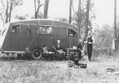
Photograph, Mr. and Mrs. East camping in Illoura Ave., East Ringwood 1941
Typed below photograph, "Mr. and Mrs. East camping in Illoura Ave., East Ringwood opposite "Alexandra Ave. Christmas 1941." Written on backing sheet, "Caravan in paddock opposite home of Mr. & Mrs. Harry Thomas, Alexander Road, Ringwood, Christmas 1941". (2 copies). -
 Greensborough Historical Society
Photograph - Digital image, Frank Robinson, Looking across the Plenty River from Pope's paddock to Blackjack, 1954_
Looking across the Plenty River from Pope's paddock to Blackjack. The Blackjack property, house and acres of fruit orchards ran down to the Plenty River off Hume Street Greensborough and was the home of the Robinson family to late 1956. The photographs were taken as slides by Frank Robinson and digitised by his son James in 2015.Digital copy of colour photograph.blackjack, popes paddock, robinson family