Showing 647 items
matching public parks
-
 Phillip Island Conservation Society Inc.
Work on paper - newspaper cutting photocopy, "...the dress-suited jesters of the feathered world/Parade of the Fairy Penguins", unknown
The general public was fascinated by the nightly 'Penguin Parade' on Phillip Island. Many articles have been written about the birds and the Penguin Parade attraction since the 1930s. So many people spent their summer holidays on Phillip Island in one of the many guest houses, then caravan parks and holiday homes and a visit to the Penguin Parade by them and their visitors was very common during their holidays. Articles tended to be a mix of basic penguin behavior information and anthropomorphic descriptions. Accompanying photographs were almost invariably taken by flashlight (now illegal), or of penguins taken from their burrows during daylight hours for photo opportunities. The article provides evidence of the level of knowledge about Phillip Island's Little/Fairy Penguins at this time. (approx 1960?)Photocopy of 2 page magazine article. Black print. Images poor quality due old photocopy.little penguins, fairy penguins, eudyptula minor, phillip island penguin parade, dorothy vernon, penguin rookery, penguin behaviour, phillip island tourist attractions -
 Phillip Island Conservation Society Inc.
Work on paper - Photocopy of newspaper cutting, (part obscured) "at Phillip Island/Nightly Miracle/from the sea", November 20, 1957
The general public was fascinated by the nightly 'Penguin Parade' on Phillip Island. Many articles have been written about the birds and the Penguin Parade attraction since the 1930s. So many people spent their summer holidays on Phillip Island in one of the many guest houses, then caravan parks and holiday homes and a visit to the Penguin Parade by them and their visitors was very common during their holidays. Articles tended to be a mix of basic penguin behavior information and anthropomorphic descriptions. Accompanying photographs were almost invariably taken by flashlight (now illegal), or of penguins taken from their burrows during daylight hours for photo opportunities. This article, written in the 1950s, describes the management of the Penguin Parade at that time as being run by the Penguin Preservation Committee. This was before the Phillip Island Council took over running the Penguin Parade. The article provides evidence of the level of knowledge about Phillip Island's Little/Fairy Penguins at this time. (1957)single full-page magazine article, black ink on white paper. Photocopied from original, so photos appear as black and white.little penguins, fairy penguins, eudyptula minor, phillip island penguin parade, dorothy vernon, penguin rookery, penguin behaviour, phillip island tourist attractions -
 Phillip Island Conservation Society Inc.
Work on paper - Photocopy of newspaper cutting, The Express, "SURFERS' FIRES KILL/ PENGUINS - FIREMEN//NOT US:/SURFERS"
Written during the 1960s when surfing was burgeoning across Australia’s coast and Phillip Island surf beaches had become extremely popular, few management strategies were in place to control interaction of the public with the delicate flora and fauna of the coastal environments. There were few good access tracks, car parks, bins, toilets etc at coastal/surfing hotspots around the Phillip Island coast. A number of management issues occurred with the influx of surfers. These included dune erosion caused by surfers climbing dunes to see the surf before going on the beach; informal parking on wildlife habitat; numerous access paths from wherever cars were parked down to the beach cutting through habitat; illegal camping on foreshores; illegal lighting of fires on beach and in dunes; surfers’ dogs let out of the car while surfers were out on the water. The dogs were uncontrolled. Certainly some surfers behaved responsibly, as is almost invariably the case these days. However, in that era of this article few people understood the delicate nature of the coastal environment and that it need to be protected through public education, infrastructure and enforcement of regulations. As now, most rural Fire services were run by dedicated volunteers who faced many challenges in their roles as Country Fire Authority firefighters. However, it was not uncommon for visitors and locals to also assist with fire-fighting efforts.The article is significant in containing quotes from both sides of the discussion who were directly involved in coastal fire incidents on Phillip Island in the 1960s. It also indicates the large number of surfers visiting Phillip Island beaches, the volunteer nature of the firefighting service and the extra challenges they faced on Phillip Island as a visitor destination. The anonymous university student surfer who is quoted, also describes possible causes of the fires, methods he and his fellow surfers used to extinguish the fires and raise the alarm, and the way they assisted the volunteer firefighters . The reference to him breaking into one of the Summerland housing estate holiday houses is also significant because that housing estate was purchased over 2 decades by successive Victorian governments to remove management issues caused to the wildlife habitat on Summerland Peninsula.Photocopy of newspaper cuttings including 2 related articles. Five columns of black text on white paper with one poorly reproduced photo bottom rightphillip island, cat bay, country fire authority, artie murdoch, alf towns, frank dixon, barry thompson, newhaven-san remo rural fire brigade, penguin parade, cowrie beach, surfers, coastal fires -
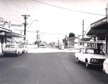
 City of Kingston
Photograph - Black and white, Public Transport Corporation, c. 1960
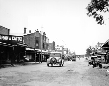
This image is part of a larger collection of images from the Public Transport Corporation displaying train stations and streetscapes in what is now the City of Kingston.Black and white photograph depicting the run in to the level crossing at Cheltenham railway station, along Charman Road. The image also depicts a streetscape which includes a shopping strip. The level gates are closed and two cars can be seen stopping and waiting, while several more cars are parked on each side of the road.Stamped in blue ink on reverse: COPYRIGHT / Public Transport Corporation / For re-ordering photographs / Please quote negative No H3378 / Enquiries C/- PTC Photographic Unit / Telephone switchboard 619 111cheltenham, railway station, streetscape, surburb -
 City of Kingston
Photograph - Black and white, c. 1960
This image is part of a larger collection of images from the Public Transport Corporation displaying train stations and streetscapes in what is now the City of Kingston.Black and white photograph depicting the level crossing at Highett, with the shopping street visible in the foreground. There are several cars parked on both sides of the road and a bus has just crossed the crossing (on the left hand side).Stamped in blue ink on reverse: COPYRIGHT / Public Transport Corporation / For re-ordering photographs / Please quote negative No H3983 / Enquiries C/- PTC Photographic Unit / Telephone switchboard 619 111highett, railway station, suburbs, streetscape -
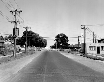 City of Kingston
Photograph - Black and white, Public Transport Corporation, c. 1960
Black and white photograph depicting closed crossing gates at the level crossing at Park Road, Cheltenham. This image is part of a larger collection of images from the Public Transport Corporation displaying train stations and streetscapes in what is now the City of Kingston.Black and white photograph of Cheltenham level crossing at Park Road, Cheltenham. The gates are closed. Stamped in blue ink on reverse: COPYRIGHT / Public Transport Corporation / For re-ordering photographs / Please quote negative No H3052 / Enquiries C/- PTC Photographic Unit / Telephone switchboard 619 111 White paper stuck to reverse of image, with black typed text: Cheltenham Park Road, Cheltenham / 1965 / $50 reproduction fee appliescheltenham, railway crossing, suburbs, public transport -
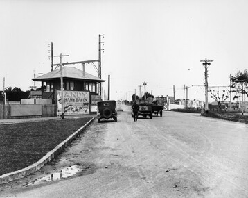 City of Kingston
Photograph - Black and white, c. 1930
This image is part of a larger collection of images from the Public Transport Corporation displaying train stations and streetscapes in what is now the City of Kingston.The Nepean Highway is a major highway running through the City of Kingston. This image is one of many that depicts its importance to the local community as it undergoes many changes over time.Black and white photograph depicting the level crossing at Moorabbin. While the gates at the level crossing are open, two cars are making their way across the crossing, while a third car is parked on the side of the road, in front of a large billboard/hoarding for ham and bacon products. There is a man standing on the road as if watching the cars go through the crossing. The road appears to be unsealed. Black printed text on a round white sticker adhered to the reverse: 148 Handwritten in red ink: 60% Blue ink stamped on reverse: COPYRIGHT / Public Transport Corporation / For re-ordering photographs / Please quote negative No ADU907 / Enquiries C/- PTC Photographic Unit / Telephone switchboard 619 111moorabbin, trains, railway crossing, level crossing, cars, roads, nepean highway -
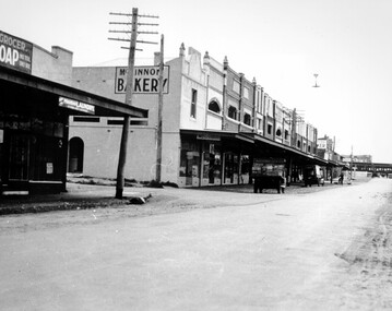 City of Kingston
Photograph - Black and white, c. 1930
Black and white photograph of McKinnon Road, McKinnon. The shopping strip can be seen on the left of the image, along with a couple of trucks parked along the roadway. There a train visible in the distance, crossing at the level crossing while the gates are closed.Typed in black on white strip of paper stuck to reverse: McKinnon Road, McKinnon / circa late twenties/early thirties / $50 reproduction fee applies Blue ink stamped on reverse: COPYRIGHT / Public Transport Corporation / For re-ordering photographs / Please quote negative No ADV 491 / Enquiries C/- PTC Photographic Unit / Telephone switchboard 619 111mckinnon, suburbs, shopping strip, trains, level crossing -
 City of Kingston
Photograph - Black and white, c. 1925
This image explores the relationship between the train lines and community development. Cheltenham's retail centre is connected to the train station.Black and white image of Charman Road, Cheltenham, depicting a car and truck travelling toward the level crossing near the train station. There is another car already waiting at the crossing gates. Cars are parked on either side of the road along a shopping strip.Black printed text on a white round sticker adhered to the reverse: 141 Handwritten in red ink on reverse: 50% Black typed text on a white strip of paper adhered to reverse: Charman Road, Cheltenham / circa late 1920's/early 1930's / $50 reproduction fee applies Blue ink stamped on reverse: COPYRIGHT / Public Transport Corporation / For re-ordering photographs / Please quote negative ADV 485 / Enquiries C/- PTC Photographic Unit / Telephone switchboard 619 1111cheltenham, trains, railway, railway crossing, shopping strip, cars -
 City of Kingston
Photograph - Colour, 6 March 1993
Edithvale is a suburb in the City of Kingston. It is located between Aspendale and Chelsea on the Port Phillip Bay and built within remnant areas of the Carrum Carrum swamp. The foreshore precinct comprises a wide sandy beach, with low sand dunes and numerous historic boat sheds. The suburb consists of older style dwellings and former holiday houses, combined with mid-century housing and newer homes. The large blocks are increasingly subdivided and the existing dwellings demolished to accommodate units and townhouses, thus changing the landscape of the area and reducing the tree canopy.The beachside suburb of Edithvale was previously part of the extensive Carrum Carrum Swamp. The area was once a source of fish and eels for the Mayone-Bulluk clan of the Bunurong people. Over time the area was drained and predominantly devoted to dairy farming and holiday houses. The farms were gradually sold and subdivided with a large number of homes built after World War II and in the 1960s. Edithvale is mainly residential with a shopping strip along Nepean Highway but little significant industry was ever established in the area apart from a plaster works and confectionary factory, both now closed.Laminated aerial colour photograph of Edithvale as viewed from Alexandra Avenue in the north to Ella Grove Chelsea/Edithvale in the south. regents Park Aspendale can be seen in the top left. The area is built-up with residential housing and facilities including Edithvale Primary School, numerous churches and the Edithvale Railway station. Large sections depict the remnant Carrum Carrum swamp. Edithvale Common and the former "Duck Inn" (Melbourne Water/Friends of Edithvale Seaford Wetlands) can be seen. Edithvale Recreational reserve, the valodrome and Edithvale Public Golf Course are prominent. The image shows vacant land in the area now known as Aspendale Gardens and the newer residential section of Chelsea Heights is not developed. A bike path has been established to cover the secondary drain. The Golf Links Court residential development located off Hughes Avenue is a large vacant block.Black type on white adhesive label: 6-3-93 Black type on white adhesive label: 25/9211, 6/3/93, 11.20 am Black type on white adhesive label: 9211 Yellow circular adhesive sticker Black pencil: 9211 6-3-93 arrow pointing Nedthvale, carrum carrum swamp, aspendale, chelsea -
 City of Kingston
Photograph - Black and white, c. 1908
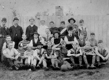
Australian rules football began being played on a regular basis in Cheltenham in 1890. Teams would not only play locally but travel by train fairly long distances, such as to Ballarat, for the day, play a game, turn around and come home. The Cheltenham home games were played on a paddock on the corner of Park and Charman roads in Cheltenham. In 1907 the Cheltenham progress committee made an application to the board of land works for land in Weatherall Road for recreational service to the public. That application was received and granted, then developed where Cheltenham Recreational Reserve now stands. The ground was opened in 1909 and the first Cheltenham side entered in the newly formed Federal Football League along with seven other foundation members, Mordialloc, Mentone, Moorabbin, Frankston, Glenhuntly, Elsternwick, and Ellindale. The grand final for that year, 1909 was a hard encounter between Cheltenham and Ellindale with Cheltenham coming out victors, thus becoming the inaugural Federal Football League premiers. The Federal Football League (FFL), also known simply as the Federal League, was an Australian rules football competition in the south-eastern suburbs of Melbourne, Victoria. The competition was in existence from 1909 to 1981 and was regarded as one of the strongest metropolitan leagues in Melbourne.Black and white image of the players and officials of the Cheltenham Football Club. Back (left to right) G Puttick, Franklyn (sic), Unkown, Unknown, C Corstorphine, D Arland, Dave Hughes, H Bryant, Centre: T Elliott, S Parsons, F Judd, H Foreman, N Corstorphine, J McCormack, S Chandler, H Orr. Front: H Clayton - no other names recorded. The players are wearing what appears to be a range of club jumpers, with some in street wear. Some players seated in the front row have mud visible on the soles of their shoes, indicating they may have already played a gam. The ball on the ground in front of the group is round.Round red sticker on reverse with handwritten text: X10 Handwritten in blue ink: A11, with a circle around it Handwritten in red ink: 50%sport, football, cheltenham, teams, federal football league -
 Melbourne Legacy
Document, Early History of the Shrine of Remembrance, c1928
After the first world war there was a decision made to create a memorial. Legatees were involved in the process at various times and capacities. In particular Legatee Kemsley was vocal in idea of a structure over a utilitarian memorial (such as a hospital or a park) - see letter at 01182. These notes include the resolution that passed at the Melbourne Town Hall at a public meeting: "That this meeting of citizens confirm the launching of an appeal by the Lord Mayor to establish a National War Memorial by means of a monument and that an executive committee with the Lord Mayor as Chairman with power to add and point sub-committees be formed to carry out the project." Also that 20 sites were selected for consideration in 1921. Although the St Kilda Road site was favoured early on, by 1926 there was pressure to change to a "provision of square" and Cenotaph at the intersection of Spring and Bourke Streets. Legacy Clubs voiced their opposition to this proposal by passing a resolution "That the Melbourne Legacy Club, representative of the returned soldiers in business in this city, whilst welcoming the Anzac Square Scheme as a city improvement, cannot support it as a War Memorial scheme and affirms its support for the Shrine of Remembrance in the Domain as the only War Memorial worthy of Victoria's unparalleled efforts in the Great War." The document was in an envelope with a letter dated 30 April 1971 (01182) that also outlines the efforts Legacy (especially L/- Kemsley) went through to promote the construction of the Shrine of Remembrance over a proposed square. The envelope says 'The Origin of the Shinre of Remembrance p/p Legatees Kemsley and Joynt'. And the initial 'JMBA'?. It was in a file with other documents concerning the Shrine and it's history.A record of the events that led to the construction of the Shrine of Remembrance as noted by a Legatee at the time. There was an effort to record historical events for the "Archive Committee" which collected this an other documents relating to the Shrine together in a file (see items 01181 - 01190)Five white foolscap pages of black type recording major events in the history of building the Shrine (covering the years from 1926 - 1928).memorial, shrine of remembrance -
 Melbourne Legacy
Document - Speech, In Proud Remembrance - from a speech by Colonel A. N. Kemsley, E.D. at a weekly luncheon of Melbourne Legacy, pre 1953
A document containing a speech by Colonel A. N. Kemsley, E.D. at a weekly luncheon at Legacy sometime in the early 1950s. He presented details of the initial building of the Shrine and the changes being made to commemorate the second world war, such as the forecourt and new cenotaph and flagpoles. He mentions the upcoming Anzac Day in 1953. After the first world war there was a decision made to create a memorial. Legatees were involved in the process at various times and capacities. In particular Legatee Kemsley was vocal in idea of a structure over a utilitarian memorial (such as a hospital or a park) - see letter at 01182. These notes include the resolution that passed at the Melbourne Town Hall at a public meeting: "That this meeting of citizens confirm the launching of an appeal by the Lord Mayor to establish a National War Memorial by means of a monument and that an executive committee with the Lord Mayor as Chairman with power to add and point sub-committees be formed to carry out the project." Also that 20 sites were selected for consideration in 1921. Although the St Kilda Road site was favoured early on, by 1926 there was pressure to change to a "provision of square" and Cenotaph at the intersection of Spring and Bourke Streets. Legacy Clubs voiced their opposition to this proposal by passing a resolution "That the Melbourne Legacy Club, representative of the returned soldiers in business in this city, whilst welcoming the Anzac Square Scheme as a city improvement, cannot support it as a War Memorial scheme and affirms its support for the Shrine of Remembrance in the Domain as the only War Memorial worthy of Victoria's unparalleled efforts in the Great War." The document was in an envelope with a letter dated 30 April 1971 (01182) that also outlines the efforts Legacy (especially L/- Kemsley) went through to promote the construction of the Shrine of Remembrance over a proposed square. The envelope says 'The Origin of the Shrine of Remembrance p/p Legatees Kemsley and Joynt'. And the initial 'JMBA'?. It was in a file with other documents concerning the Shrine and it's history.A record of the events that led to the construction of the Shrine of Remembrance as noted by a Legatee at the time. There was an effort to record historical events for the "Archive Committee" which collected this an other documents relating to the Shrine together in a file (see items 01181 - 01190, 01206 - 01212)White quarto paper x 8 pages of black type of a speech given by Legatee Kemsley.S6 in red penmemorial, speech, shrine of remembrance, kemsley -
 Melbourne Legacy
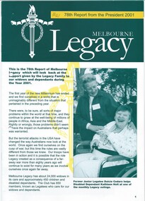
Document - Report, 78th Report from the President 2001, 2001
In 2003 David Grierson was the president and was about to hand over to Tony Parkes. His report shows pictures from many of the activities the widows are involved in such as exercise classes, walks and the preparation of rosemary sprigs for Anzac Day. The report also recaps events through the year such as outings and camps for the junior legatees, legacy week and the public speaking contest. Up to the 1980s the annual report would usually contain pages containing the Presidents report and photos of significant events of the year. Between 1987 and 1990 these were published in a separate document called 'Highlights from the Annual Report'. This could be used in promoting Legacy in different ways, without all the financial information normally held in an annual report. In following years it became called 'Report from the President' then 'Highlights from the President', before becoming 'Melbourne Legacy Highlights' which was published twice a year from 2007. It was eventually renamed, 'The Torch, Melbourne Legacy Highlights' in 2012. 'The Torch' is still published twice a year. Other annual reports in 00027, 01095, 01096 and 01097, 01098, 01310 and 01311. A record of the annual reports of Legacy Melbourne, including activities and telling stories of Legacy's impact.Colour printed president's report from 2001 x 8 pages, with photos.annual summary, activities -
 Melbourne Legacy
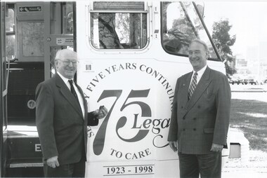
Photograph, Legacy Tram, 1995
Photo of a white tram painted to celebrate 75 years of Legacy work. As well as the 75 Legacy logo, it says "Legacy - Helps the families of our departed Veterans" and "75 years on ... Legacy still caring. 1923-1998". Photos show people posing before boarding for a ride. The photo with 4 women includes Joan Miller, who was a valuable staff member as well as being a Legacy widow and Carmel McConnell who was the public relations officer for Legacy. Another photo shows widows and handicapped dependents posing, the lady on the top step is Margaret Anderson. The tram is possibly parked near the Shrine. Other photos show there were speeches and refreshments held in a marquee and a ribbon being cut be Legacy President Tom Butcher and Robin Cooper the Victorian Minister for Transport.A record of a way to promote Legacy during the anniversary in 1998.Black and white photo x 4 of a tram painted to promote to Legacy's 75th Anniversary.legacy promotion, tram, 75th anniversary -
![Map, [Coornmill land area available for leasing for grazing, Parish of Coornmill]. Circa 1904](/media/collectors/5e461d8021ea67224c82f2a1/items/677cde147f2053f3e5d277c3/item-media/677cdeea7f2053f3e5d27bb4/item-fit-380x285.jpg) Bacchus Marsh & District Historical Society
Bacchus Marsh & District Historical SocietyMap, [Coornmill land area available for leasing for grazing, Parish of Coornmill]. Circa 1904
This map shows an area of land north of Bacchus Marsh in the Larderderg State Park area known as the Parish of Coornmill.The map indicates an area of land which was to be made available by public tender for grazing leaseholders. The plan to do this was discussed in the Bacchus Marsh Express newspaper on the 16 July, 1904, page 2, column 7. The area reserved for grazing leases is identified by red lines on the map. The Express described the area available for grazing was 12,000 acres.A single page paper map showing an area of land in the Parish of Corrnmill to be made available for grazing leases. A photo lithographed Lands Department Map. No scale indicated. The map is pasted into a bound volume containing 76 maps or plans in total. High resolution digital image stored on BMDHS computer network. coornmill parish maps, lerderderg state park maps, agriculture bacchus marsh area -
 Ballarat Tramway Museum
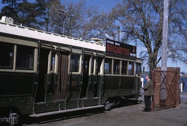
Slide - Set of 5, Warren Doubleday, Ballarat - last day of the Lydiard St Nth to Sebastopol line, 19/9/1971
Photos taken on the last day of the SECV operated tram services in Ballarat 19/9/1971 1 - Tram 35 running out of the depot. 2 - Scrubber parked on "0" Road. 3 - SEC Jelbart Roller in depot. 4 - Tram 42 running empty at View Point - corner of Macarthur St and Wendouree Parade. 5 - tram 34 running out in Wendouree Parade.Yields information about the last day of SEC public operations in Ballarat.Set of 5 Kodachrome colour slides - cardboard mountsHave the photographer's slide numbers written on them.trams, tramways, closure, tram 35, scrubber, jelbart, road roller, tram 34, tram 42 -
Port Melbourne Historical & Preservation Society
Book - Reference, Grids and Greenery. The Character of Inner Melbourne, 1987
"Grids and Greenery. The Character of Inner Melbourne" A largely pictorial account of how inner Melbourne's public spaces have developed from early settlement to the 1980s. 71 pages, white cover with grey grid and bright colours on the frontbuilt environment - civic, natural environment, parks and gardens -
 Linton and District Historical Society Inc
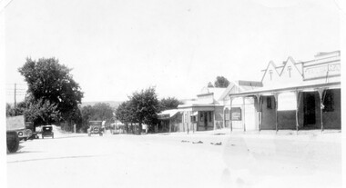
Photograph, Sussex Street, Linton - view to north, late 1920s or early 1930s
Dated to late 1920s or early 1930s as Nelson building has been renovated as a Californian bungalow. The earlier curvilinear parapet on the library building (see photo - Registration no. 166) has been squared off, and a small pedimented timber parapet has been added above.Black and white photograph of Linton's main street, Sussex Street. View of Railway Hotel, Nelson undertaker building, public library and "cash emporium". Cars parked and driving along Sussex St."Linton Main Street".sussex street linton, railway hotel, nelson undertakers, linton public library, cash emporium, transport, cars -
Lakes Entrance Historical Society
Book, Land Conservation Council Victoria, Final Recommendations Gippsland Lakes hinterland Area, 1983
1980 report and recommendations of the Victorian Land Conservation Council, for the balanced use of public land in teh gippsland Lakes Hinterland includes reserves schools forests rivers foreshores and other public sites. Map and diagrams added.topography, parks, waterways -
Lakes Entrance Historical Society
Book, Land Conservation Council Victoria, Land Conservation Council East Gippsland Area Review, 1985
Report describing the physical and biological aspects of the public land in the eastern corner of Victoria, predominantly the Orbost Shire. Many issues are covered in the report, including timber industry, national parks, waterways and tourism. Six mapsparks, waterways, tourism, gippsland -
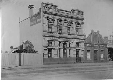 Port Melbourne Historical & Preservation Society
Photograph - Various Port Melbourne buildings, Public Records Office Victoria (PROV), 1886 - 1982
COPYRIGHT Public records Office Victoria 02 - 1886 building as marked on rear, but actually a 20th century photo .03 - 1886 document .04 - 1914 bank staff .05 - 1942 building with cars at front .06 1948 building with cars (incl Holden) parked at front .07 1975 building .08 - 1975 building .09 - 1978 building with cars .10 - 1980 building with cars .11 - 1982 building with carsbuilt environment - commercial, business and traders, transport - motor vehicles, state savings bank of victoria, general motors-holden, gmh -
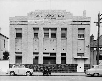 Port Melbourne Historical & Preservation Society
Photograph - SSB building with cars and motorbike parked outside c 1942, Public Records Office Victoria (PROV), 1886 - 1982
... with cars and motorbike parked outside c 1942 Public Records Office ...The State Savings Bank building was constructed c1891. The street frontage has been remodeledCOPYRIGHT Public records Office Victoria .05 - remodeled 1942 building with cars at front built environment - commercial, business and traders, transport - motor vehicles, state savings bank of victoria -
University of Melbourne, Burnley Campus Archives
Newspaper - Newspaper Cutting, The Age, Victorian Horticultural Society, 1862
(1) Photocopy of article in "The Age" 30 January, 1862 p7. (2) Similar article from "the Argus" 30 January, 1962 p4. Description of the annual general meeting of the Victorian Horticultural Society. Description of a competition for a design and that the decorative part of the garden was nearly complete and open to the public. Donors of plants named including Rule (Californian Redwood?) Extension of Swan Street through Richmond Park, past Pic Nic Station to the Gardens and River Yarra.the age, the argus, victorian horticultural society, horticultural society of victoria, monthly meeting, competition for design of experimental gardens, burnley gardens, rule, californian redwood, donations of plants, pic nic station -
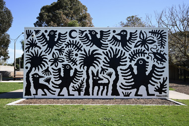 Wyndham Art Gallery (Wyndham City Council)
Artwork, other, Minna Leunig, Movement and Mirth in Kelly Park
Muralpublic art, mural, australian art -
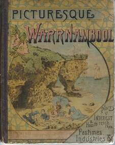 Warrnambool and District Historical Society Inc.
Book, Picturesque Warrnambool, 1891
This book presents a pictorial and written record of Warrnambool in 1891.It covers a wide range of topics. It provides statistical evidence relating to public buildings and organisations of that era, as well as basic information about district points of interest. The Mechanics Institute, the Common, Albert Park, the rivers, the Museum and the Sea Baths are all mentioned. The various drawings and advertisements provide a list of businesses which were prevalent at the time. As this book is one of only two complete copies documented to be still in existence, it is of considerable significance and importance to our collection. The drawings and text are artistically very much of the era and are aesthetically pleasing. Cardboard cover with picture of people on beach in tones of yellow, pink and blue sitting within a circle. Dark purple cloth spine binding. Back cover has drawing of Western Hotel. Pages are not numbered and there are a number of coloured and black and white drawings. Title is in dark purple and Warrnambool is in pink and blue tonesOn front cover “The Mermaids Caves” 1896. 1891 written in pen beneath roman numerals on bottom of title page. List of numbers written down title page in black pen.warrnambool, picturesque warrnambool, warrnambool 1891,, warrnambool, warrnambool 1891 -
 Wooragee Landcare Group
Photograph, 28th April 2004
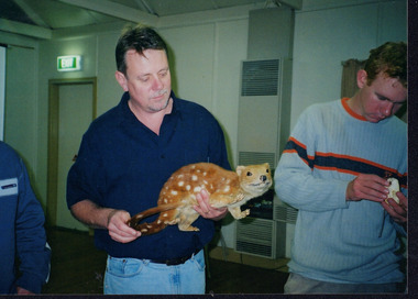
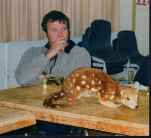
Wooragee Landcare was formed in 1989 to promote sustainable conservation and land-use practices in the North-East region of Victoria. The organisation's work has included public awareness and education campaigns to control invasive, introduced species and protect native wildlife, such as campaigns to bait or trap foxes and to identify and monitor quoll populations in the region. The organisation has drawn on the work of a variety of Government and academic experts to inform best practice approaches are utilised. In 2004 Andrew Murray, a leading quoll expert from Parks Victoria, conducted training for Wooragee Landcare members and the local community in how to identify potential quoll habitat and populations (through identifying scat and other methods). Spotted-tail or Tiger quolls were known to have lived in the Mt Pilot and Stanley Plateau region previously but habitat encroachment, competitor species such as foxes and natural disasters had reduced sightings in recent years. The Spotted-Tail quoll (formerly known as the Tiger Quoll) is the largest of four species of native marsupial carnivore on mainland Australia, and the second-largest carnivore (after the dingo). The species' scientific name, Dasyurus maculatus, references its' 'hairy tail'. Adults are approximately 125cm long, including their long tail, and weigh around 5 kilograms. The Spotted-tail quoll is currently considered to be a threatened species, but other species are currently listed as endangered.This photograph is significant as an example of wildlife protection awareness programs undertaken by Wooragee Landcare Group in the 2000s in Indigo Shire.Landscape coloured photograph printed on gloss paper.Reverse: WAN NA 0ANA2N0 NNN+ 1 8743 / [PRINTED] (No.23) / 269wooragee, wooragee landcare, indigo shire, north-east victoria, andrew murray, queries about quolls, wildlife, conservation, farming, predators, spotted tail quolls, quolls, marsupials, south-east forests, mt pilot, stanley plateau -
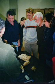 Wooragee Landcare Group
Photograph, 28th April 2004
This photograph was taken at Wooragee Hall on Wednesday the 28th of April 2004 as part of an event called 'Queries about Quolls'. This event was hosted by the Wooragee Landcare Group and was led by Andrew Murray, President of the South East Forest Spotted-tailed Quoll Working Group and one of Victoria's leading authorities in quolls. As the name of the event would suggest, this session provided attendees with insight and general information on quolls, including the characteristics of quolls, the habitat of quolls and the techniques that can be used when searching for quolls. This event was likely part of a wider project aimed at protecting the endangered species of the tiger quoll, also known as the spotted-tailed quoll, an animal that once inhabited Mount Pilot-Chiltern National Park. The Tiger Quoll is the largest of the quoll species. Largely resembling a cross between a possum and a cat, the quoll is distinctive due to the white spots that are often found all over its brown fur. This photograph is significant as it provides evidence of a project undertaken by the Wooragee Landcare Group to educate members of the public on the tiger quoll in the early 2000s in an attempt to better understand and protect the species. The Wooragee Landcare Group has been instrumental in the co-ordination of programs relating to biodiversity protection in the local area, providing great assistance to landholders. Portrait coloured photograph printed on gloss paper.Reverse: WAN / NA / OANA2NO / NNN+ / 2 / 8743 / wooragee, wooragee hall, wooragee landcare, wooragee landcare group, quoll, spotted-tailed quoll, tiger quoll, queries about quolls, south east forest spotted-tailed quoll working group, andrew murray quolls, andy murray quolls, mount pilot chiltern national park, quoll species, endangered quoll -
 Wooragee Landcare Group
Photograph, 28th April 2004
This photograph was taken at Wooragee Hall on Wednesday the 28th of April 2004 as part of an event called 'Queries about Quolls'. This event was hosted by the Wooragee Landcare Group and was led by Andrew Murray, President of the South East Forest Spotted-tailed Quoll Working Group and one of Victoria's leading authorities in quolls. As the name of the event would suggest, this session provided attendees with insight and general information on quolls, including the characteristics of quolls, the habitat of quolls and the techniques that can be used when searching for quolls. This event was likely part of a wider project aimed at protecting the endangered species of the tiger quoll, also known as the spotted-tailed quoll, an animal that once inhabited Mount Pilot-Chiltern National Park. The Tiger Quoll is the largest of the quoll species. Largely resembling a cross between a possum and a cat, the quoll is distinctive due to the white spots that are often found all over its brown fur.This photograph is significant as it provides evidence of a project undertaken by the Wooragee Landcare Group to educate members of the public on the tiger quoll in the early 2000s in an attempt to better understand and protect the species. The Wooragee Landcare Group has been instrumental in the co-ordination of programs relating to biodiversity protection in the local area, providing great assistance to landholders.Square coloured photograph printed on gloss paper. Reverse: + 3 8748 / 265 wooragee, wooragee hall, wooragee landcare, wooragee landcare group, quoll, spotted-tailed quoll, tiger quoll, queries about quolls, south east forest spotted-tailed quoll working group, andrew murray quolls, andy murray quolls, mount pilot chiltern national park, quoll species, endangered quoll -
 Buninyong & District Historical Society
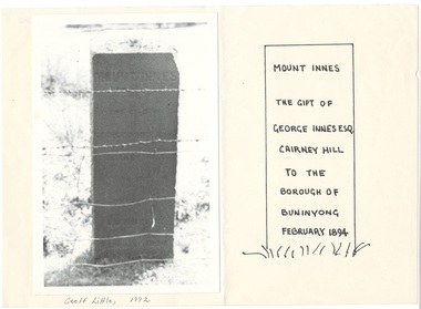
Photograph - Photograph of Buninyong from Mt. Innes, 1993. mounted on paper, Monument to George Innes, Mt. Innes, 1993
historic, public land, landscape, B/W photograph of George Innes monument on Mt. Innes, now known as Birdwood Park, mounted next to drawing showing inscription, which is illegible in photo. George Innes donated the land for the reserve.Mount Innes The gift of George Innes Esq. Cairney Hill to the borough of Buninyong February 1894buninyong, mt. innes, george innes