Showing 2300 items matching "railway line"
-
 Eltham District Historical Society Inc
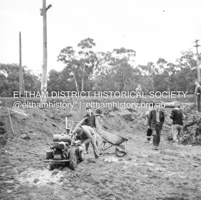
Negative - Photograph, J.A. McDonald, Eltham, Cecil Street, Sep. 1959
... looking west across Main Road to the railway line... looking west across Main Road to the railway line Record ...Stabilising junction with Eltham-Yarra Glen Road View looking west across Main Road to the railway lineRecord of various Shire of Eltham infrastructure works undertaken during the period of 1952-1962 involving bridge and road reconstruction projects, sometimes with Eltham Shire Council Project Reference numbers quoted. It was during this period that a number of significant improvements were made to roads and new bridges constructed within the shire that remain in place as of present day (2022). In many situations, the photos provide a tangible visible record of infrastructure that existed throughout the early days of the Shire. The album was put together by or under the direction of the Shire Engineer, J.A. McDonald.infrastructure, shire of eltham, road construction, cecil street, eltham, eltham-yarra glen road, main road, 1959-09 -
 Greensborough Historical Society
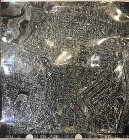
Aerial Photograph, Yan Yean M/S 7922 Run 17 No. 3833-20, 01/11/1984
... boundary Price Park; West boundary Hurstbridge railway line... Hurstbridge railway line rosanna viewbank heidelberg Laminated black ...Covers Rosanna and parts of Viewbank and Heidelberg. East boundary Price Park; West boundary Hurstbridge railway lineLaminated black and white aerial photograph; adjoins 6226 on east siderosanna, viewbank, heidelberg -
 Federation University Historical Collection
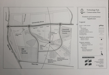
Map, Matthew Cibson, University of Ballarat Centre for Environmental Management, Ballarat Technology Park Conservation Plan, 1997, 02/1997
... sleepers, Ballarat-Buninyong Railway Line, IBM Global Services... sleepers, Ballarat-Buninyong Railway Line, IBM Global Services ...The Ballarat Technology Park is on the Federation University Mount Helen CampusMap showing the Ballarat Technlogy Camp, Greenhill Enterprise Centre, Canadian Wetlands. hand-made brick culvert sleepers, Ballarat-Buninyong Railway Line, IBM Global Services, early wooden bridge, Canadian Creek, Gear Avenue. ballarat technology park, canadian wetlands, greenhill enterprise centre, brick cultert, railway, ballarat-buninyong railway -
 Glenelg Shire Council Cultural Collection
Photograph - Photograph - Canal Bridge Construction, n.d
... Black and white photo looking north from PHT railway line... and white photo looking north from PHT railway line. Canal bridge ...Port of Portland Authority Archivesport of portland archives, canal bridge -
 Bacchus Marsh & District Historical Society
Map, Maddingley Township, Parish of Parwan, circa 1890s
... , rivers, creeks, park lands, the railway line and Bacchus Marsh..., the railway line and Bacchus Marsh railway station in the township ...Maddingley is a locality or township within the broader township area of Bacchus Marsh. This map is not dated. However features in Maddingley which appeared in the 1880s and 1890s are present in the map, These include the Bacchus Marsh Railway Station and the Bacchus Marsh Showgrounds. The main residential and commercial area of Maddingley is shown on this map in an area bounded by Bacchus Street, Barry Street, Griffith Street and Maddingley Road. Other streets visible are Franklin Street, Inglis Street, Labilliere Street, McCrae Street, Moore Street and part of Station Street.A single page paper map showing land allotments, streets, rivers, creeks, park lands, the railway line and Bacchus Marsh railway station in the township of Maddingley. The map is pasted into a bound volume containing 76 maps or plans in total. bacchus marsh victoria maps, maddingley victoria maps, land use, maddingley victoria history -
 Bendigo Historical Society Inc.
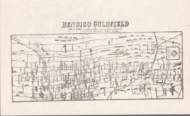
Map - BENDIGO GOLDFIELD MAP
... . Streets, Railway Line, Lines of Reefs and mines are shown. Dept... of the Bendigo Goldfield Map. Streets, Railway Line, Lines of Reefs ...Two not very clear copies of the Bendigo Goldfield Map. Streets, Railway Line, Lines of Reefs and mines are shown. Dept. of Mines, Victoria printed on the map. Shows reefs from Bird's Line of Reefs to Lightning Hill Line of Reef.map, bendigo, goldfields, bendigo goldfield map, lines of reefs, dept. of mines victoria -
 Stawell Historical Society Inc
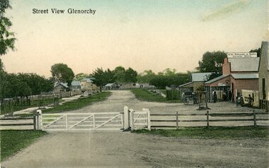
Photograph, Glenorchy road Scene from the Rialway line with Mr M.W. Edwards & Son's General Store on the right -- Postcard
... Street view Glenorchy Post Card taken from railway line... grampians Street view Glenorchy Post Card taken from railway line ...Street view Glenorchy Post Card taken from railway line. On right M.W. Edwards & Son. General Storestawell, streetscape -
 Sunbury Family History and Heritage Society Inc.
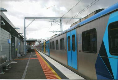
Photograph, Rosa McCall, November 2012
... of the railway line was completed to Sunbury in 2012 and the Metro train... of the railway line was completed to Sunbury in 2012 and the Metro train ...The photograph was taken when the electrification of the railway line was completed to Sunbury in 2012 and the Metro train services commenced running in November.For 153 years Sunbury had relied on a regional train service to Melbourne. The extension of the electrified Metro service provided the town with more frequent services.A coloured scanned photograph of a stationary electric train at a railway station. metro trains, electrification, railways, sunbury -
 University of Melbourne, Burnley Campus Archives
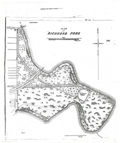
Plan - Photocopy, A.L. Martin et al, Plan of Richmond Park, 1872
... Layout of Richmond Park showing railway line, Pic-Nic...Layout of Richmond Park showing railway line, Pic-Nic ...Layout of Richmond Park showing railway line, Pic-Nic Station, Swan Street extension and Horticultural Society's Garden. 3 photocopies of plan surveyed and drawn by A.L. Martin, Authorised Surveyor. Photolithographed at Dept of Lands and Survey by J. Noone 6th Sept. 1872. Showing the entire park and the Horticultural Society's Garden.richmond, parks, a.l. martin -
 Tatura Irrigation & Wartime Camps Museum
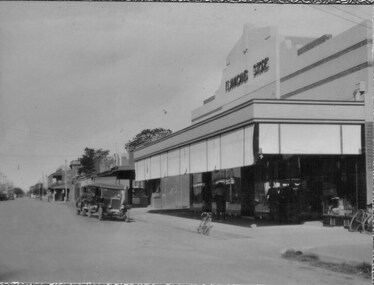
Photos, Hogan Street Tatura
... railway line, c.1910.|Flanagans Store c.1935, showing shop... looking east from railway line, c.1910.|Flanagans Store c.1935 ...Early Tatura photos emailed.|Hogan Street looking east from railway line, c.1910.|Flanagans Store c.1935, showing shop on corner and possibly the first fire station on N.E. corner of Ross & Hogan Streets.|Hogan Street looking west from railway line c.1910(2).|Flanagans' Store on cnr. Ross and Hogan Streets, c.1910.tatura, hogan street, flanagans store, local, history -
 Greensborough Historical Society
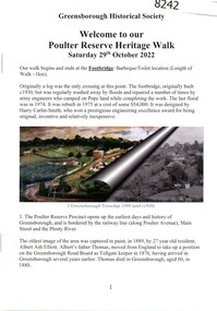
Booklet, Greensborough Historical Society, Poulter Reserve Heritage Walk, 29/10/2022
... The Poulter Reserve precinct is bordered by the railway... is bordered by the railway line, Main Street and the Plenty River ...The Poulter Reserve precinct is bordered by the railway line, Main Street and the Plenty River. This booklet accompanies a guided walk around the area.20 p., text and color and black and white images.poulter reserve greensborough, main street greensborough, plenty river greensborough -
 Eltham District Historical Society Inc
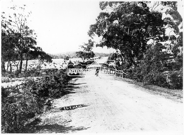
Negative - Photograph, Main Road, Eltham, c.1905
... . There is no railway line evident so prior to the extension to Hurstbridge.... There is no railway line evident so prior to the extension to Hurstbridge ...Eltham, Main Road. Looking north from Cecil Street. There is no railway line evident so prior to the extension to Hurstbridge (1912)This photo forms part of a collection of photographs gathered by the Shire of Eltham for their centenary project book,"Pioneers and Painters: 100 years of the Shire of Eltham" by Alan Marshall (1971). The collection of over 500 images is held in partnership between Eltham District Historical Society and Yarra Plenty Regional Library (Eltham Library) and is now formally known as the 'The Shire of Eltham Pioneers Photograph Collection.' It is significant in being the first community sourced collection representing the places and people of the Shire's first one hundred years.Digital image 4 x 5 inch B&W Negsepp, shire of eltham pioneers photograph collection, eltham, main road -
 City of Kingston
Pamphlet - Colour, Roy Dunn Pty. Ltd, Subdivisional auction of Highett Station Estate, c.1924
... by Worthing Road, and the Melbourne to Frankston Electric Railway Line... by Worthing Road, and the Melbourne to Frankston Electric Railway Line ...Sales plan for land in the suburb of Highett, bounded by Worthing Road, and the Melbourne to Frankston Electric Railway Line, including LePage Street. The developing urban area of Highett within the City of Kingston. This land sale pamphlet illustrates the subdivision of land within the municipality and the changing demographic of the district as new houses are constructed close to infrastructure.Colour pamphlet advertising a subdivisional auction of the Highett Station Estate. Incorporates a map of the estate bordered by Worthing Road and the Melbourne to Frankston Electric Railway, and including LePage Street. Handwritten in black ink on front cover: Late LePage / Wickham Rdland sales, estate, highett -
Whitehorse Historical Society Inc.
Document, Mines report, 1894
... on inspection along the railway line between Blackburn and Box Hill... on inspection along the railway line between Blackburn and Box Hill ...Mimes Registrar's unpublished report 1894/5913 on inspection along the railway line between Blackburn and Box Hill and on Canterbury Road.Mimes Registrar's unpublished report 1894/5913 on inspection along the railway line between Blackburn and Box Hill and on Canterbury Road. Mr Wellington states he obtained colours of gold. Signed James Stirling With previous related file papers.Mimes Registrar's unpublished report 1894/5913 on inspection along the railway line between Blackburn and Box Hill and on Canterbury Road.miming, stirling, james -
 Greensborough Historical Society
Map, Greensborough Map with Rail Line Plan, 1970s
... Central Greensborough area, including railway line and some..., including railway line and some landowners. Basic map made c. 1902 ...Central Greensborough area, including railway line and some landowners. Basic map made c. 1902; annotations dated to circa 1970sTwo copies of planParish of Keelbundora, County of Bourke. Central Greensborough areagreensborough, greensborough railway station -
 City of Kingston
Pamphlet - Colour, Highett Town, 1888
... by Highett Road, Worthing Terrace and the railway line... by Highett Road, Worthing Terrace and the railway line ...Sales plan for land in the suburb of Highett, bounded by Highett Road, Worthing Terrace and the railway line, and incorporating Major Street and Train Street.The developing urban area of Highett within the City of Kingston. This land sale pamphlet illustrates the subdivision of land within the municipality and the changing demographic of the district as new houses are constructed close to infrastructure.Colour pamphlet advertising for private sale the Station Entrance Estate, Highett. Incorporates a map of the estate bordered by Wickham Road, Railway Parade, Highett Road and Point Nepean Road.land sales, highett -
 Greensborough Historical Society
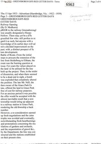
Newspaper Clipping (copy), Greensborough's red letter days; railway opening, by D. Medhurst, 13/04/1933
... of the extension of the railway line between Heidelberg and Eltham... of the extension of the railway line between Heidelberg and Eltham ...Account of the background to the construction of the extension of the railway line between Heidelberg and Eltham, and the effects of the railway service on the Greensborough, Briar Hill and Montmorency areas.3 p. OCR transcript of original article (copied from Trove)railways, hurstbridge rail line -
 Orbost & District Historical Society
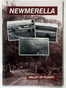
book, Newmerella Valley of Plenty, 2010
... . One is a photograph of the railway line with a steam train... of the railway line with a steam train on the rail viaduct. Newmerella ...This is a 2nd edition of an earlier print, 1978. It has been revised and edited by John Phillips for the Orbost & District Historical Society in 2010. Harry Grosvenor was the headmaster at Newmerella School from 1962 to 1972. Harry was deeply involved in the 1978 publication by the Newmerella Progress Association called: Newmerella - Valley of Plenty. The book is a pictorial history of the early Newmerella district ( west of the Snowy River ).This is a local history book written by Harry Grosvenor a local author.A paperback book, titled Newmerella Valley of Plenty. The front cover is brown with white text and has three b/w photographs of the Snowy River flats as sen from the Newmerella hill. One is a photograph of the railway line with a steam train on the rail viaduct. newmerella-history -
 Ballarat Tramway Museum
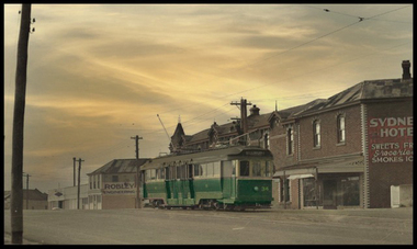
Photograph - Digital image, mid 1950's
... in Mercer St between Corio and Bayley St, just where the railway... the railway line to Cunningham Period went underneath. Tram has ...Digital Image from a coloured postcard of Geelong 34 in Mercer St between Corio and Bayley St, just where the railway line to Cunningham Period went underneath. Tram has destination of Belmont. In the background are a building for Robley Engineering and the Sydney Hotel. trams, tramways, geelong, mercer st, bogie trams, tram 34 -
 Otway Districts Historical Society
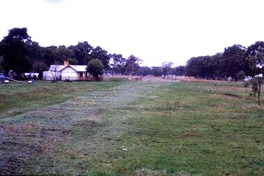
Photograph, Langford, Weston, Gellibrand after closure, 1964, 26 April 1964
... Colour. After closure of the railway line, Gellibrand... closure of the railway line, Gellibrand looking towards Beech ...Colour. After closure of the railway line, Gellibrand looking towards Beech Forest on 26 April 1964. The station buildings and water tank are still standing as well as clear impressions left by the tracks. Telephone lines are marked. A person is near the water tank.gellibrand; railways; -
 Orbost & District Historical Society
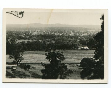
black and white photograph, late 19th / early 20th century?
... been taken before the railway line was there.... to have been taken before the railway line ...This photograph shows a distant view of the Orbost township taken from Grandview Lookout at Newmerella. It appears to have been taken before the railway line was there.This is a pictorial record of early Orbost.A small black / white photograph of the Orbost township taken from Grandview Lookout , Newmerella. The main road can be seen below with paddocks of crops on both sides.on back - "Distant View, Orbost from Grandview"orbost-township-c19th grandview-lookout orbost-flats-paddocks -
 Greensborough Historical Society
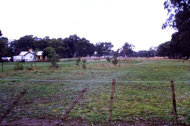
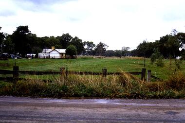
Slide - Photograph, John Ramsdale, Rail line near Whittlesea: Slide 120, 1990s
... and paddock, this is part of the site of the old railway line... railway line to Whittlesea. In centre of photo is the old station ...Photograph shows what appears to be a rural farmhouse and paddock, this is part of the site of the old railway line to Whittlesea. In centre of photo is the old station platform.Part of the John Ramsdale collection of slides and audio visual material.Colour photograph scanned from slide.No maker's marks. No caption on slide.whittlesea, whittlesea rail line -
 Greensborough Historical Society
Slide - Photograph, John Ramsdale, Rail line near Whittlesea: Slide 94, 1990s
... and paddock, this is part of the site of the old railway line... railway line to Whittlesea. In centre of photo is the old station ...Photograph shows what appears to be a rural farmhouse and paddock, this is part of the site of the old railway line to Whittlesea. In centre of photo is the old station platform.Part of the John Ramsdale collection of slides and audio visual material.Colour photograph scanned from slide.No maker's marks. No caption on slide.whittlesea, whittlesea rail line -
 Greensborough Historical Society
Slide - Photograph, John Ramsdale, Old Whittlesea rail line: Slide 107, 1990s
... and paddock, this is part of the site of the old railway line... railway line to Whittlesea. In centre of photo is the old station ...Photograph shows what appears to be a rural farmhouse and paddock, this is part of the site of the old railway line to Whittlesea. In centre of photo is the old station platform.Part of the John Ramsdale collection of slides and audio visual material.Colour photograph scanned from slide.No maker's marks. No caption on slide.whittlesea, whittlesea rail line -
 Otway Districts Historical Society
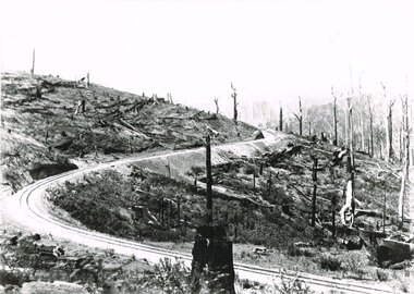
Photograph, Victorian Railways, Bend 21.5 miles looking south, 1901
... Banool station is 34.1 km down the railway line from Colac... the railway line from Colac: this photograph was taken 34.6 km down ...Banool station is 34.1 km down the railway line from Colac: this photograph was taken 34.6 km down the line, half a kilometre onwards.B/W. A bend in the line 21.5 miles (34.6 km) looking south.banool; beech forest; railways; -
 Buninyong Visitor Information Centre
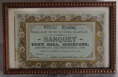
Document - Ticket, Framed ticket to the Official Opening of the Buninyong Railway Banquest 1889, 1889
... Railway line on Thursday, 12 September 1889. ... for the Buninyong Railway line on Thursday, 12 September 1889. Trains ...Ticket printed for use by people attending a banquet held during the official opening celebrations for the Buninyong Railway line on Thursday, 12 September 1889. Printed ticket in a bronze coloured frame, with floral motif around the ticket edges. Not used.Unused. Issued by Robert M. Harvey, Hon. Secretary.trains, railways, buninyong railway -
 Buninyong & District Historical Society
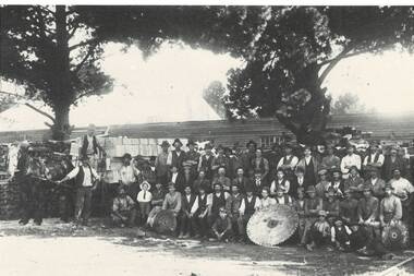
Photograph - Photograph of original photo of Howard's Buninyong Box Factory, Derek Leather, Howard's Buninyong Box Factory, marking opening of branch rail line across Learmonth St. 1922. Employees gathered for photo, August 1995
... and other products. A railway line crossed the Main Road... products. A railway line crossed the Main Road to the factory which ...Buninyong Industrial historyB/W photo of original sepia phot workers lined up at Howard's Buninyong Box Factory, marking opening of spur rail line across Learmonth St. in 1922."The sawmill where the boxes were made for the Butter and other products. A railway line crossed the Main Road to the factory which was on the land below the Watkin's house (once the Railway Hotel, the brick house on the side of Larmonth St. hill.)box factory, learmonth st., railway spur -
 Greensborough Historical Society
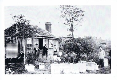
Photograph, Home of Mr Coghill Greensborough, 1910c
... house located between the railway line and the Plenty River... was the former Mitchell house located between the railway line ...Shows the home of Mr Coghill which was the former Mitchell house located between the railway line and the Plenty River and directly opposite the end of Jessop Street.This shows the type of dwelling the early settlers lived in, also what they had in their cottage gardens.A rectangular black and white photograph of 4 men and 1 woman in a garden outside a shingle hut with bee hives near them.shingle hut, cottage garden, bee hives, coghill, mitchell, 1910 -
 Greensborough Historical Society
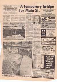
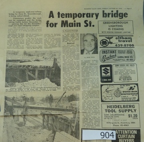
Newspaper clipping, A temporary bridge for Main Street, 24/10/1978
... to the construction of a road bridge over the railway line.... closure due to the construction of a road bridge over the railway ...Leading up to the opening of Greensborough Plaza, traffic along Main Street was affected by the part closure due to the construction of a road bridge over the railway line.Significant infrastructure changes in Greensborough at the time of the opening of Greensborough Plaza in 1978.Photocopy of news clipping (Item 958). Text and black and white images. -
 Greensborough Historical Society
Newspaper clipping, A temporary bridge for Main Street, 24/10/1978
... to the construction of a road bridge over the railway line.... closure due to the construction of a road bridge over the railway ...Leading up to the opening of Greensborough Plaza, traffic along Main Street was affected by the part closure due to the construction of a road bridge over the railway line.Significant infrastructure changes in Greensborough at the time of the opening of Greensborough Plaza in 1978.Original news clipping (Item 904) and photocopy of same (Item 958). Text and black and white images.main street greensborough, para road, railway, greensborough plaza