Showing 40555 items matching "roads and streets"
-
 Whitehorse Historical Society Inc.
Map, City of Nunawading Street and Block Map
City of Nunawading Street and Block map.City of Nunawading Street and Block map. Scale: 1:10,000. with enlargement, Canterbury Road South to Burwood Highway.City of Nunawading Street and Block map. canterbury road nunawading, burwood highway burwood east, city of nunawading -
 Whitehorse Historical Society Inc.
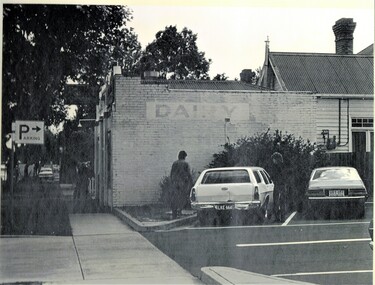
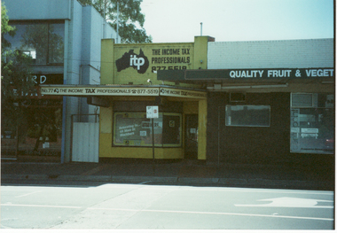
Photograph, Old Dairy at Blackburn, 1983
Donor developed Educational Programme for Blackburn Lake.Laser Print of black and white photo of Old Dairy at Blackburn - Corner Railway Road and Albert Street. (Mounted)meagher, dorothy, railway road, blackburn, albert street, blackburn -
 Whitehorse Historical Society Inc.
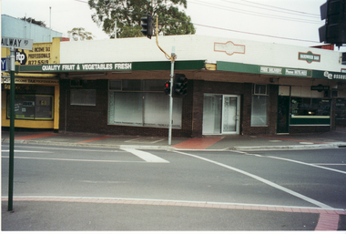
Photograph, Pearce Shop, 1/03/2002 12:00:00 AM
Coloured photograph of site of original shop owned by Mary Pearce on corner of Railway Road & Chapel Street, Blackburn.pearce, ronald, harry, mary, railway road, blackburn, chapel street -
 Whitehorse Historical Society Inc.
Photograph, Pearce Shop, 1/03/2001 12:00:00 AM
Coloured photograph of site of original shop owned by Mary Pearce on Corner of Railway Road and Chapel Street, Blackburn.railway road, blackburn, chapel street, pearce, mary -
 Whitehorse Historical Society Inc.
Photograph, Pearce Shop, 21/03/2001 12:00:00 AM
Coloured photograph of site of original shop owned by Mary Pearce on Corner of Railway Road and Chapel Street, Blackburn.pearce, ronald, harry, mary, railway road, blackburn., chapel street, blackburn -
 Whitehorse Historical Society Inc.
Photograph, Pearce Shop
Coloured photograph of site of original shop owned by Mary Pearce on Corner of Railway Road and Chapel Street, Blackburn.pearce, ronald, harry, mary, railway road, blackburn, chapel street -
 Whitehorse Historical Society Inc.
Photograph, Pearce Shop, 21/03/2001 12:00:00 AM
Coloured photograph of site of original shop owned by Mary Pearce on Corner of Railway Road and Chapel Street, Blackburn.pearce, ronald, harry, mary, railway road, blackburn, chapel street -
 Whitehorse Historical Society Inc.
Photograph, Pearce Shop, 21/03/2001 12:00:00 AM
Coloured photograph of site of original shop owned by Mary Pearce on Corner of Railway Road and Chapel Street, Blackburn.pearce, ronald, harry, mary, railway road, blackburn, chapel street -
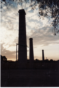 Whitehorse Historical Society Inc.
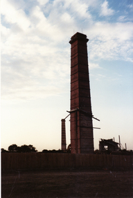
Photograph, Vitclay, 1995
Vitclay Chimneys prior to demolition in 1995. Springfield Road, Blackburn North, looking West from Primrose Street.vitclay, springfield road, blackburn north, potteries, clay industries -
 Whitehorse Historical Society Inc.
Photograph, Vitclay, 1995
Vitclay Chimney, prior to demolition in 1995. Springfield Road, Blackburn North, looking West from Primrose Street.vitclay, springfield road, blackburn north, potteries, clay industries -
 Whitehorse Historical Society Inc.
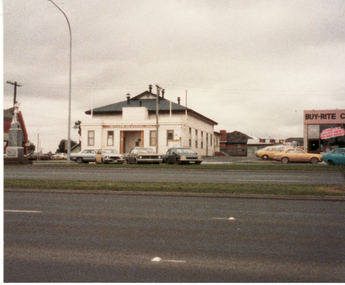
Photograph, Memorial Hall, Mitcham, 13/06/1986 12:00:00 AM
2 Coloured photos of Memorial Hall, Corner Whitehorse Road and McDowall Street, Mitcham. Shows War Memorial.mitcham memorial hall, war memorial, mitcham, soldiers memorial -
 Whitehorse Historical Society Inc.
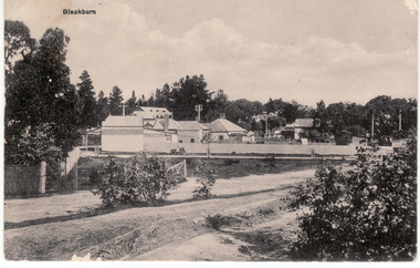
Postcard, Blackburn Road and Railway Road Blackburn C1908, 1908
Black and white postcard entitled 'Blackburn' Scene shows corner Railway and Blackburn Roads, Albert Street unmade.railway road, blackburn, hooke, janet emily, blackburn road blackburn, albert arthur -
 Whitehorse Historical Society Inc.
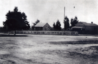
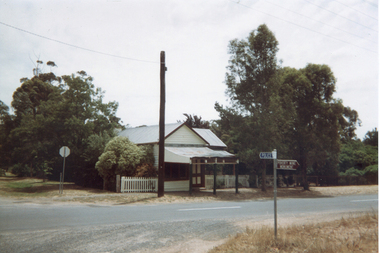
Photograph, Christ Church, Mitcham
Black and white photograph of Christ Church Mitcham and Horneman Butchers, situated on Edwards Street. Whitehorse Road in the foregroundchrist church anglican church mitcham, horneman butchers -
 Kew Historical Society Inc
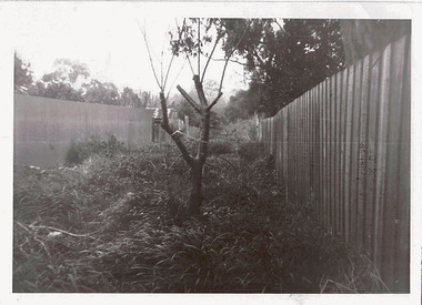
Photograph - Right-of-way at rear of Parkhill Road and Lalla Street, 1973
One of a series of photographs donated by the City Engineer of the former City of Kew, relating to road works and rubbish removal.One of a series of photographs of core local government services as practised by the City of Kew. The photographs are an accurate record of council works of the period.Original black and white photographic an overgrown right-of-way at the rear of properties in Parkhill Road and Lalla Street, Kew"ROW AT REAR OF PROPERTIES / PARKHILL RD / LALLA ST / JULY '73"city of kew, local government -- city of kew, council works, street maintenance, right-of-ways, lanes -
 Kew Historical Society Inc
Plan - Subdivision Plan, Glenferrie Road & Wellington St, Kew, c.1920s
Subdivision plans are historically important documents used as evidence of the growth of suburbs in Australia. They frequently provide information about when the land was sold on which a built structure was subsequently constructed as well as evidence relating to surveyors and real estate and financial agents. The numerous subdivision plans in the Kew Historical Society's collection represent working documents, ranging from the initial sketches made in planning a subdivision to printed plans on which auctioneers or agents listed the prices for which individual lots were sold. In a number of cases, the reverse of a subdivision plan in the collection includes a photograph of a house that was also for sale by the agent. These photographs provide significant heritage information relating house design and decoration, fencing and household gardens.An unnamed subdivision in Kew including eleven lots for sale bordering Glenferrie Road, Wellington Street and Franks Grove.subdivision plans - kew, franks grove, wellington street, glenferrie road -
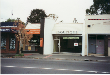
Canterbury History Group
Photograph - Street view of the business at No. 121 Maling Road, Canterbury, Stuart Warmington, 1995
Coloured photograph of street view of the business at No. 121 Maling Road, Canterbury. Laneway visible between the 2 premisescanterbury, maling road, shops, laneways -
Canterbury History Group
Photograph - Street view of Maling Road, Canterbury from the west, looking east from Bradshaw's garage, Stuart Warmington, 1995
Coloured photograph of street view of Maling Road, Canterbury from the west, looking east from Bradshaw's garagecanterbury, maling road, shops -
 Tarnagulla History Archive
Photograph, Former Corner Shop, Tarnagulla, early 1990s
Donald Clark Collection. A colour photograph depicting a corner shop building, on the corner of King Street and Commercial Road in Tarnagulla. Original photograph. -
Canterbury History Group
Photograph - "Roquebrune" corner Canterbury Road and Gascoyne Street Canterbury, c1920
The house was built in 1912 or 1914 for G. H. Tarrant and was demolished in 1971 to make way for the Baptist Nursing Home. Now apartments.Sepia photograph of three people sitting in the front garden of "Roquebrune" corner of Canterbury Road and Gascoyne Street Canterbury. canterbury, canterbury road, gascoyne street, edwardian style, roquebrune, nursing homes, baptist nursing home -
Canterbury History Group
Photograph - Streetscape of the corner of Bryson Street and Maling Road, Jan Pigot, 1994
Coloured photograph of the streetscape of the corner of Bryson Street and Maling Road. This is also the corner of the building named The Block 1907.canterbury, maling road, shops, bryson street, the block, buckley family -
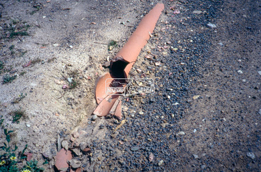
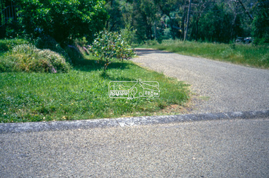
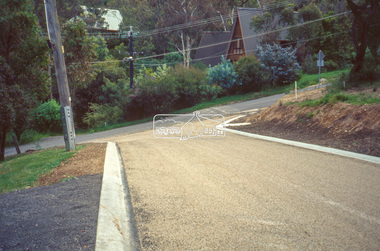
 Eltham District Historical Society Inc
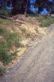
Slide - Photograph, Eltham Shire Council, Roadside drainage control, unidentified road, Shire of Eltham, c.1989
... Roads ...Eltham Shire Council review of various kerb profiles and road side drainage35mm colour positive transparency Mount - Black and Whiteinfrastructure, footpaths and gutters, road drainage, roads, shire or eltham, streets -
 Eltham District Historical Society Inc
Slide - Photograph, Eltham Shire Council, Roadside drainage control, unidentified road, Shire of Eltham, c.1989
... Roads ...Eltham Shire Council review of various kerb profiles and road side drainage35mm colour positive transparency Mount - Black and Whiteinfrastructure, footpaths and gutters, road drainage, roads, shire or eltham, streets -
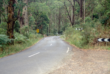 Eltham District Historical Society Inc
Slide - Photograph, Heidelberg-Kinglake Road between St Andrerws and Kinglake, 1993
... streets ...35mm colour positive transparency Mount - Black and Whiteinfrastructure, streets, roads, heidelberg-kinglake road, kinglake, st andrews -
Glenelg Shire Council Cultural Collection
Negative - Glass Plate Negative - Bentinck Street Portland, 1890-1910
Stereoscopic glass plate negative. (Same as 5771) Man holding 2 bicycles, Bentinck Street south (Cape Nelson Road) looking north from near Must Street. -
Glenelg Shire Council Cultural Collection
Negative - Glass Plate Negative - Bentinck Street Portland, c. 1890
Stereoscopic glass plate negative. Image shows a man holding 2 bicycles, Bentinck Street south (Cape Nelson Road) looking north from near Must Street. -
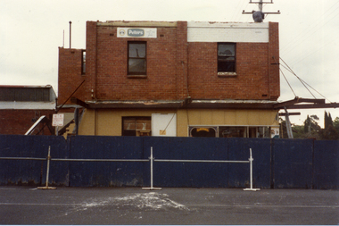 Whitehorse Historical Society Inc.
Photograph, Demolition Site, 1/11/1983 12:00:00 AM
Coloured photo of demolition site on corner of Station Street and Whitehorse Road, Mitcham view from eastern side of Station Street looking west from Post Office Cornerstation street mitcham, whitehorse road mitcham, demolition site -
 Ringwood and District Historical Society
Document - Subdivision Plan, LP10477 Parish of Warrandyte, County of Evelyn, Vol 2453 Fol 574 - 1924
LANDATA Land Victoria plan printout circa 2010Part of Crown Allotment 30. Map includes Warrandyte Road, Kennedy Avenue and Wonga Road, Ringwood. Street name amended from Wonga Road to Loughnan Road 1940. Other markings include CP102182, CP171386, LP127934, PS349846, RP7582, PS309312,RP8679 and CP106336.