Showing 207153 items matching "royal-melbourne-institute-of-technology"
-
 Kew Historical Society Inc
Plan, Melbourne & Metropolitan Board of Works : Borough of Kew : Detail Plan No.1565, 1905
... Melbourne & Metropolitan Board of Works : Borough of Kew...Melbourne and Metropolitan Board of Works ...The Melbourne and Metropolitan Board of Works (MMBW) plans were produced from the 1890s to the 1950s. They were crucial to the design and development of Melbourne's sewerage and drainage system. The plans, at a scale of 40 feet to 1 inch (1:480), provide a detailed historical record of Melbourne streetscapes and environmental features. Each plan covers one or two street blocks (roughly six streets), showing details of buildings, including garden layouts and ownership boundaries, and features such as laneways, drains, bridges, parks, municipal boundaries and other prominent landmarks as they existed at the time each plan was produced. (Source: State Library of Victoria). This plan forms part of a large group of MMBW plans and maps that was donated to the Society by the Mr Poulter, City Engineer of the City of Kew in 1989. Within this collection, thirty-five hand-coloured plans, backed with linen, are of statewide significance as they include annotations that provide details of construction materials used in buildings in the first decade of the 20th century as well as additional information about land ownership and usage. The copies in the Public Record Office Victoria and the State Library of Victoria are monochrome versions which do not denote building materials so that the maps in this collection are invaluable and unique tools for researchers and heritage consultants. A number of the plans are not held in the collection of the State Library of Victoria so they have the additional attribute of rarity.Original survey plan, issued by the MMBW to a contractor with responsibility for constructing sewers in the area identified on the plan within the Borough of Kew. The plan was at some stage hand-coloured, possibly by the contractor, but more likely by officers working in the Engineering Department of the Borough and later Town, then City of Kew. The hand-coloured sections of buildings on the plan were used to denote masonry or brick constructions (pink), weatherboard constructions (yellow), and public buildings (grey). MMBW Plan No.1565 is an example of a plan where a number of streets have been created since the area was surveyed, or in other cases renamed. The plan shows those streets that were bordered by Ross Street, Mount Street, Sackville Street and Burke Road. Since 1905, Mawson Street has been created and Mont Albert Road renamed as Dean Street. Named houses on the plan include ‘Tyrol’, ‘Glengorse’, ‘Theodore Villa’, ‘Arncliffe’, ‘Ballynira’ and ‘Hazeldene’. The plan also shows a Wesleyan Church in Sackville Street. In 1883, the Church’s Sunday School celebrated its silver anniversary.melbourne and metropolitan board of works, detail plans, mmbw 1565, cartography -
 Kew Historical Society Inc
Plan, Melbourne & Metropolitan Board of Works : Borough of Kew : Detail Plan No.1568, 1905
... Melbourne & Metropolitan Board of Works : Borough of Kew...Melbourne and Metropolitan Board of Works ...The Melbourne and Metropolitan Board of Works (MMBW) plans were produced from the 1890s to the 1950s. They were crucial to the design and development of Melbourne's sewerage and drainage system. The plans, at a scale of 40 feet to 1 inch (1:480), provide a detailed historical record of Melbourne streetscapes and environmental features. Each plan covers one or two street blocks (roughly six streets), showing details of buildings, including garden layouts and ownership boundaries, and features such as laneways, drains, bridges, parks, municipal boundaries and other prominent landmarks as they existed at the time each plan was produced. (Source: State Library of Victoria)This plan forms part of a large group of MMBW plans and maps that was donated to the Society by the Mr Poulter, City Engineer of the City of Kew in 1989. Within this collection, thirty-five hand-coloured plans, backed with linen, are of statewide significance as they include annotations that provide details of construction materials used in buildings in the first decade of the 20th century as well as additional information about land ownership and usage. The copies in the Public Record Office Victoria and the State Library of Victoria are monochrome versions which do not denote building materials so that the maps in this collection are invaluable and unique tools for researchers and heritage consultants. A number of the plans are not held in the collection of the State Library of Victoria so they have the additional attribute of rarity.Original survey plan, issued by the MMBW to a contractor with responsibility for constructing sewers in the area identified on the plan within the Borough of Kew. The plan was at some stage hand-coloured, possibly by the contractor, but more likely by officers working in the Engineering Department of the Borough and later Town, then City of Kew. The hand-coloured sections of buildings on the plan were used to denote masonry or brick constructions (pink), weatherboard constructions (yellow), and public buildings (grey). Plan No.1568 covers the area bounded by Cotham Road, John Street, Sackville Street, and Edward Street. Alfred Street and Rowland Street are in shown in the middle of the plan. The two most notable buildings shown are ‘St Helliers’, the home of the Dumaresq family, and St Hilary’s Church and school. While the colours used to indicate St Hilary’s are grey as in other civic/public buildings, the first St Hilary’s Anglican Church was at this stage constructed in weatherboard. At the left of the plan, facing Sackville Street is a house named ‘Glencara’. The 1988 ‘Kew Conservation Study’ recorded that “The first documentary evidence of this house comes from Rate Books which record that in 1893 a Mrs Treadway was the owner of this building with an N.A.V. of £81? At that date the occupier of the house was Charles B. Kelly, a clerk, while by 1910 Kelly had become the owner of the property described in that year ‘as a six-roomed stone, brick and wood house with stables and outbuildings’”. Contrary to this description, the 1905 plan indicates that the house was entirely constructed of masonry.melbourne and metropolitan board of works, detail plans, mmbw 1568 -
 Kew Historical Society Inc
Plan, Melbourne & Metropolitan Board of Works : Borough of Kew : Detail Plan No.1570, 1905
... Melbourne & Metropolitan Board of Works : Borough of Kew...Melbourne and Metropolitan Board of Works ...The Melbourne and Metropolitan Board of Works (MMBW) plans were produced from the 1890s to the 1950s. They were crucial to the design and development of Melbourne's sewerage and drainage system. The plans, at a scale of 40 feet to 1 inch (1:480), provide a detailed historical record of Melbourne streetscapes and environmental features. Each plan covers one or two street blocks (roughly six streets), showing details of buildings, including garden layouts and ownership boundaries, and features such as laneways, drains, bridges, parks, municipal boundaries and other prominent landmarks as they existed at the time each plan was produced. (Source: State Library of Victoria)This plan forms part of a large group of MMBW plans and maps that was donated to the Society by the Mr Poulter, City Engineer of the City of Kew in 1989. Within this collection, thirty-five hand-coloured plans, backed with linen, are of statewide significance as they include annotations that provide details of construction materials used in buildings in the first decade of the 20th century as well as additional information about land ownership and usage. The copies in the Public Record Office Victoria and the State Library of Victoria are monochrome versions which do not denote building materials so that the maps in this collection are invaluable and unique tools for researchers and heritage consultants. A number of the plans are not held in the collection of the State Library of Victoria so they have the additional attribute of rarity.Original survey plan, issued by the MMBW to a contractor with responsibility for constructing sewers in the area identified on the plan within the Borough of Kew. The plan was at some stage hand-coloured, possibly by the contractor, but more likely by officers working in the Engineering Department of the Borough and later Town, then City of Kew. The hand-coloured sections of buildings on the plan were used to denote masonry or brick constructions (pink), weatherboard constructions (yellow), and public buildings (grey). Plan No.1570 shows the layout of gardens and houses in Sackville Street, Davis Street, Wrixon Street, and Fitzwilliam Street in 1904. While Thomas Street is included on the map, at this stage no houses had been built. The plan identifies two named houses: ‘Fairview’ and ‘Kylemore’. Fairview is more fully delineated in Plan No.1563. Kylemore is one of the few houses in Kew designed by John Beswicke. The most notable owner of Kylemore was William Whitehead, who owned the house between 1895 and 1900. In 1894, Australian newspapers reported the marriage of Whitehead’s daughter to Dr. Gerald Eugene Cussen, the brother of Sir Leo Cussen, the Supreme Court Judge. The married couple was to live at ‘Wilton’ (now the Kew RSL) from 1911-15.melbourne and metropolitan board of works, detail plans, mmbw 1570, cartography -
 Kew Historical Society Inc
Plan, Melbourne & Metropolitan Board of Works : Borough of Kew : Detail Plan No.1571, 1904
... Melbourne & Metropolitan Board of Works : Borough of Kew...Melbourne and Metropolitan Board of Works ...The Melbourne and Metropolitan Board of Works (MMBW) plans were produced from the 1890s to the 1950s. They were crucial to the design and development of Melbourne's sewerage and drainage system. The plans, at a scale of 40 feet to 1 inch (1:480), provide a detailed historical record of Melbourne streetscapes and environmental features. Each plan covers one or two street blocks (roughly six streets), showing details of buildings, including garden layouts and ownership boundaries, and features such as laneways, drains, bridges, parks, municipal boundaries and other prominent landmarks as they existed at the time each plan was produced. (Source: State Library of Victoria)This plan forms part of a large group of MMBW plans and maps that was donated to the Society by the Mr Poulter, City Engineer of the City of Kew in 1989. Within this collection, thirty-five hand-coloured plans, backed with linen, are of statewide significance as they include annotations that provide details of construction materials used in buildings in the first decade of the 20th century as well as additional information about land ownership and usage. The copies in the Public Record Office Victoria and the State Library of Victoria are monochrome versions which do not denote building materials so that the maps in this collection are invaluable and unique tools for researchers and heritage consultants. A number of the plans are not held in the collection of the State Library of Victoria so they have the additional attribute of rarity.Digital copy of the original survey plan, issued by the MMBW to a contractor with responsibility for constructing sewers in the area identified on the plan within the Borough of Kew. The plan was at some stage hand-coloured, possibly by the contractor, but more likely by officers working in the Engineering Department of the Borough and later Town, then City of Kew. The hand-coloured sections of buildings on the plan were used to denote masonry or brick constructions (pink), weatherboard constructions (yellow), and public buildings (grey). This plan is part of a large and historically significant group of MMBW plans and maps that was donated to the Society by the Mr Poulter, City Engineer of the City of Kew in 1989. When the contracts were let for surveyors to identify and record the extant houses and landscapes within an area for the Board of Works, the contracts were let at separate times, hence the anomaly where two copies of Plan No.1571 exist in our collection. The first of these plans identifies the building materials used in houses bordering Fitzwilliam Street, Edgevale Road, May Street, Malin Street, Davis Street and Wellington Street. The cut off point for the survey was the south side of Wellington Street. By 1903 when the survey was undertaken many of the sites were already built on, particularly those facing Edgevale Road. The plan identifies the preponderance of weatherboard houses in the area. The other version of the plan identifies the buildings between Wellington Street and Cotham Road.melbourne and metropolitan board of works, detail plans, mmbw 1571, cartography -
 Kew Historical Society Inc
Plan, Melbourne & Metropolitan Board of Works : Borough of Kew : Detail Plan No.1571, 1904
... Melbourne & Metropolitan Board of Works : Borough of Kew...Melbourne and Metropolitan Board of Works ...The Melbourne and Metropolitan Board of Works (MMBW) plans were produced from the 1890s to the 1950s. They were crucial to the design and development of Melbourne's sewerage and drainage system. The plans, at a scale of 40 feet to 1 inch (1:480), provide a detailed historical record of Melbourne streetscapes and environmental features. Each plan covers one or two street blocks (roughly six streets), showing details of buildings, including garden layouts and ownership boundaries, and features such as laneways, drains, bridges, parks, municipal boundaries and other prominent landmarks as they existed at the time each plan was produced. (Source: State Library of Victoria)This plan forms part of a large group of MMBW plans and maps that was donated to the Society by the Mr Poulter, City Engineer of the City of Kew in 1989. Within this collection, thirty-five hand-coloured plans, backed with linen, are of statewide significance as they include annotations that provide details of construction materials used in buildings in the first decade of the 20th century as well as additional information about land ownership and usage. The copies in the Public Record Office Victoria and the State Library of Victoria are monochrome versions which do not denote building materials so that the maps in this collection are invaluable and unique tools for researchers and heritage consultants. A number of the plans are not held in the collection of the State Library of Victoria so they have the additional attribute of rarity.Original survey plan, issued by the MMBW to a contractor with responsibility for constructing sewers in the area identified on the plan within the Borough of Kew. The plan was at some stage hand-coloured, possibly by the contractor, but more likely by officers working in the Engineering Department of the Borough and later Town, then City of Kew. The hand-coloured sections of buildings on the plan were used to denote masonry or brick constructions (pink), weatherboard constructions (yellow), and public buildings (grey). This plan is the other half of Plan No.1571 representing the constructions to the west of Wellington Street before and in 1903/4. This plan represents the built environment in Edgevale Road, Wellington Street, Atkins Street, Annadale Street, Mortimer Street, and Cotham Road. Whereas there are smaller allotments and more modest housing stock facing Edgevale Road, larger blocks and more substantial houses are represented facing Cotham Road.melbourne and metropolitan board of works, detail plans, mmbw 1571, cartography -
 Kew Historical Society Inc
Plan, Melbourne & Metropolitan Board of Works : Borough of Kew : Detail Plan No.1572, 1905
... Melbourne & Metropolitan Board of Works : Borough of Kew...Melbourne and Metropolitan Board of Works ...The Melbourne and Metropolitan Board of Works (MMBW) plans were produced from the 1890s to the 1950s. They were crucial to the design and development of Melbourne's sewerage and drainage system. The plans, at a scale of 40 feet to 1 inch (1:480), provide a detailed historical record of Melbourne streetscapes and environmental features. Each plan covers one or two street blocks (roughly six streets), showing details of buildings, including garden layouts and ownership boundaries, and features such as laneways, drains, bridges, parks, municipal boundaries and other prominent landmarks as they existed at the time each plan was produced. (Source: State Library of Victoria)This plan forms part of a large group of MMBW plans and maps that was donated to the Society by the Mr Poulter, City Engineer of the City of Kew in 1989. Within this collection, thirty-five hand-coloured plans, backed with linen, are of statewide significance as they include annotations that provide details of construction materials used in buildings in the first decade of the 20th century as well as additional information about land ownership and usage. The copies in the Public Record Office Victoria and the State Library of Victoria are monochrome versions which do not denote building materials so that the maps in this collection are invaluable and unique tools for researchers and heritage consultants. A number of the plans are not held in the collection of the State Library of Victoria so they have the additional attribute of rarity.Original survey plan, issued by the MMBW to a contractor with responsibility for constructing sewers in the area identified on the plan within the Borough of Kew. The plan was at some stage hand-coloured, possibly by the contractor, but more likely by officers working in the Engineering Department of the Borough and later Town, then City of Kew. The hand-coloured sections of buildings on the plan were used to denote masonry or brick constructions (pink), weatherboard constructions (yellow), and public buildings (grey). Plan No. 1572 represents the built environment bordered by Barkers Road, Wrixon Street, Edgevale Road and Fitzwilliam Street. Other streets identified on the plan include Stansell Street. Plan 1572 shows that by 1903-05, there was only patchy development in this area of Kew, mainly on Edgevale Road and Fitzwilliam Street. Only two named houses are identified: the quaintly named ‘Tweed Cottage’, and ‘Mendip’. The earliest reference to Treed Cottage in Australian newspapers is to the death of Walter Thompson, aged 74 who was a resident there in 1885. His youngest daughter was to die there in 1908. Mendip to the north of Tweed Cottage was owned by Henry Thompson; he was to die in 1901; his wife in 1932. At this period of time, Malin Street and Clivedon Court did not extend to Barkers Road.melbourne and metropolitan board of works, detail plans, mmbw 1572, cartography -
 Kew Historical Society Inc
Plan, Melbourne & Metropolitan Board of Works : Borough of Kew : Detail Plan No.1573, 1905
... Melbourne & Metropolitan Board of Works : Borough of Kew...Melbourne and Metropolitan Board of Works ...The Melbourne and Metropolitan Board of Works (MMBW) plans were produced from the 1890s to the 1950s. They were crucial to the design and development of Melbourne's sewerage and drainage system. The plans, at a scale of 40 feet to 1 inch (1:480), provide a detailed historical record of Melbourne streetscapes and environmental features. Each plan covers one or two street blocks (roughly six streets), showing details of buildings, including garden layouts and ownership boundaries, and features such as laneways, drains, bridges, parks, municipal boundaries and other prominent landmarks as they existed at the time each plan was produced. (Source: State Library of Victoria)This plan forms part of a large group of MMBW plans and maps that was donated to the Society by the Mr Poulter, City Engineer of the City of Kew in 1989. Within this collection, thirty-five hand-coloured plans, backed with linen, are of statewide significance as they include annotations that provide details of construction materials used in buildings in the first decade of the 20th century as well as additional information about land ownership and usage. The copies in the Public Record Office Victoria and the State Library of Victoria are monochrome versions which do not denote building materials so that the maps in this collection are invaluable and unique tools for researchers and heritage consultants. A number of the plans are not held in the collection of the State Library of Victoria so they have the additional attribute of rarity.Original survey plan, issued by the MMBW to a contractor with responsibility for constructing sewers in the area identified on the plan within the Borough of Kew. The plan was at some stage hand-coloured, possibly by the contractor, but more likely by officers working in the Engineering Department of the Borough and later Town, then City of Kew. The hand-coloured sections of buildings on the plan were used to denote masonry or brick constructions (pink), weatherboard constructions (yellow), and public buildings (grey). This plan has detailed annotations written in red or blue ink, showing prices, which may be the annual valuations of the properties, and some owners’ names, a most unusual feature on contractor's maps. Some areas, such as the buildings of Methodist Ladies’ College (MLC), include the school’s tennis court and swimming pool, but are not coloured to show building materials – did the draftsman just run out of time, or ink, or enthusiasm, before his plan had to be submitted? MLC had been founded in 1882 as a ‘modern school of the first order’ with buildings that formed ‘a collegiate institution for girls unsurpassed in the colonies’. The goal of its founders was to provide a high-class Christian education for girls, comparable with that provided elsewhere for boys. Some shops are shown along Edgevale Road, though they are not designated as commercial premises. Larger houses are depicted, including ‘Fairlawn’ in Barkers Road, and ‘Clevedon’ and ‘Rosehill’ (now demolished) in Fitzwilliam Street.melbourne and metropolitan board of works, detail plans, mmbw 1573, maps - borough of kew, cartography -
 Kew Historical Society Inc
Plan, Melbourne & Metropolitan Board of Works : Borough of Kew : Detail Plan No.1574, 1905
... Melbourne & Metropolitan Board of Works : Borough of Kew...Melbourne and Metropolitan Board of Works ...The Melbourne and Metropolitan Board of Works (MMBW) plans were produced from the 1890s to the 1950s. They were crucial to the design and development of Melbourne's sewerage and drainage system. The plans, at a scale of 40 feet to 1 inch (1:480), provide a detailed historical record of Melbourne streetscapes and environmental features. Each plan covers one or two street blocks (roughly six streets), showing details of buildings, including garden layouts and ownership boundaries, and features such as laneways, drains, bridges, parks, municipal boundaries and other prominent landmarks as they existed at the time each plan was produced. (Source: State Library of Victoria)This plan forms part of a large group of MMBW plans and maps that was donated to the Society by the Mr Poulter, City Engineer of the City of Kew in 1989. Within this collection, thirty-five hand-coloured plans, backed with linen, are of statewide significance as they include annotations that provide details of construction materials used in buildings in the first decade of the 20th century as well as additional information about land ownership and usage. The copies in the Public Record Office Victoria and the State Library of Victoria are monochrome versions which do not denote building materials so that the maps in this collection are invaluable and unique tools for researchers and heritage consultants. A number of the plans are not held in the collection of the State Library of Victoria so they have the additional attribute of rarity.Original survey plan, issued by the MMBW to a contractor with responsibility for constructing sewers in the area identified on the plan within the Borough of Kew. The plan was at some stage hand-coloured, possibly by the contractor, but more likely by officers working in the Engineering Department of the Borough and later Town, then City of Kew. The hand-coloured sections of buildings on the plan were used to denote masonry or brick constructions (pink), weatherboard constructions (yellow), and public buildings (grey). This plan shows several very large houses, particularly along Glenferrie Road, and the area now occupied by Ruyton Girls’ School. ‘Tarring’ (incorrectly spelled here as ‘Karring’) was built for Henry Henty in 1872, on part of his original allotment of 20 acres, and ‘Mount View’, which retains its original building and the fountain in the front garden, is part of Ruyton’s Junior School. The most significant change to Tarring and its grounds since 1903, involve the removal of a number of the outbuildings, including a Burmese temple, bought by Henty from the Burmese Exhibit at the Great Exhibition of 1880. It is shown on the plan as a summerhouse. The two-storey mansion, on the corner of Glenferrie Road and Wellington Street, was built in 1891 by leading architect Alfred White as his own home. Having an initial N.A.V. of £160, the house was purchased by a warehouseman Henry Lister, by 1900, when the N.A.V. was recorded at £111. By the turn of the century the house was known as ‘Comaques’. By contrast, much smaller houses are shown in Scott and Byron Streets, including a tiny Mission Hall in Byron Street, which belonged to the Anglican Church from at least 1903 to 1917.melbourne and metropolitan board of works, detail plans, maps - borough of kew, mmbw 1574, cartography -
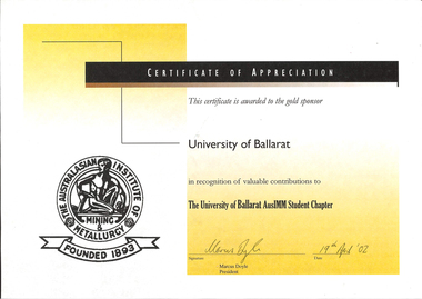 Federation University Historical Collection
Certificate, Australasian Institute of Metallurgy Certificate of Appreciation, 2002
... Australasian Institute of Metallurgy Certificate of ...The Australasian Institute of Mining and Metallurgy (AusIMM) was founded in 1893.An Australasian Institute of Mining and Metallurgy Certificate of Appreciation awarded to the University of Ballarat AusIMM Student Chapter in recognition of valuable contributions .ausimm, university of ballarat, australasian institute of mining and metallurgy, australasian institute of mining and metallurgy university of ballarat student chapter -
 Vision Australia
Text, Royal Victorian Institute for the Blind annual report 1960-1961, 1960-1961
Articles in annual report include: List of RVIB president, office bearers of the institute and officers of the institute, Programme and achievements - future programme is in your hands, Activities, Programme maintained - ninety six years of service, Recent years, Resident nursery and school, Other children's activities, Deaf blind children, Higher education, Employment, Finance, Rehabilitation, Recreation and social activities, Talking book library, Public appeal - Aug 1962, Appreciation, 3KZ Christmas day appeal, Concerts, Board of management, 35th annual report of council of auxiliary. Events that occurred in 1961 : School started a scented garden, library now has been consolidated and a new physical education block opened with an indoor heated pool, fully equipped gym, showers and dressing room.1 volumeroyal victorian institute for the blind, annual reports -
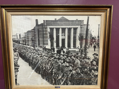 The 5th/6th Battalion Royal Victoria Regiment Historical Collection
Photograph - Photograph of The Royal Melbourne Regiment, The Royal Melbourne Regiment on parade
A photo of the Royal Melbourne Regiment when it was on parade before WWI, its been displayed in a wooden frame -
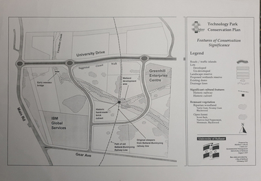 Federation University Historical Collection
Map, Matthew Cibson, University of Ballarat Centre for Environmental Management, Ballarat Technology Park Conservation Plan, 1997, 02/1997
... Matthew Cibson, University of Ballarat Centre for ...The Ballarat Technology Park is on the Federation University Mount Helen CampusMap showing the Ballarat Technlogy Camp, Greenhill Enterprise Centre, Canadian Wetlands. hand-made brick culvert sleepers, Ballarat-Buninyong Railway Line, IBM Global Services, early wooden bridge, Canadian Creek, Gear Avenue. ballarat technology park, canadian wetlands, greenhill enterprise centre, brick cultert, railway, ballarat-buninyong railway -
 Vision Australia
Administrative record - Text, Royal Victorian Institute for the Blind annual report 1962-1963, 1962-1963
Articles in annual report include: List of office bearers of the institute and officers of the institute, Confidence mobility, Annual report of the RVIB babies, Children and adults - 97 years of service and programmes - special appeal, Residence rehabilitation training centre, Conference mobility, Ten pin bowling, Deaf blind centre, Resident nursery and school, Worldwide literary competition, Higher education, Employment, Welfare, Recreation, Finance, Appreciation, Auxiliary, 3KZ Christmas appeal, Vice regal patronage, My friend the long cane - a new method of self-help for blind people, They're the workers, 36th annual report of the council of auxiliary. Events that occurred in 1962 : Hon. H.E. Bolte, Premier opened the appeal and announced a special grant of $20,000 pounds from the state government. Lieutenant General Sir Henry Wells accepted the board's invitation to become chairman of the appeal, at the Burwood school Cheng Ann Cheok a 15 year old Singaporean boy arrived to further his education and study music, he hopes to adopt music as his career. Through the kind offices of Dr Edward J. Waterhouse director of Perkins school for the blind of Boston and the generosity of its Board of Trustees a scholarship will be provided to the Institute for an Australian teacher to be trained as a specialist teacher within their school.1 volume of text and illustrationsroyal victorian institute for the blind, annual reports -
 Ithacan Historical Society
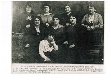
Photograph, Governing Council of Greek Women, Melbourne 1917, 1917
... Governing Council of Greek Women, Melbourne 1917 ...Melbourne, City of Melbourne, Victoria, 3000, Australia ...The photograph is of members of the Governing Council of Greek Women in Melbourne in 1917. A number of the women were from Ithaca. The organisation was created to offer social interaction for Greek women who had settled in Australia in the early years of the twentieth century and was part of the Greek Orthodox Community of Melbourne and Victoria. Back row L-R: Mrs. A Raftopoulou, Miss Sigala, Mrs. E. Peppa. Middle row L-R: Miss E. Nomikou, Mrs. K. Kyriazopoulou, (President), Mrs. K Mavrokefalou (Vice-president), Mrs. N. Mari. Front: Mrs. B. Zografou. A black and white portrait style photograph of eight young women. The translated caption is printed below the photograph in Greek: THE GOVERNING COUNCIL OF GREEK WOMEN, MELBOURNE 1917 gocv, committee, auxilliary -
 Melbourne Tram Museum
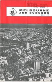
Map, Royal Automobile club of Victoria (RACv), "Melbourne and Suburbs", late 1960's
... Royal Automobile club of Victoria (RACv) ...Map - folded 8 folds or sections, printed in two colours titled "Melbourne and Suburbs", published by the RACV late 1960's, giving a map of Melbourne and its suburbs, shows all tram and rail lines, highways, freeways under construction, has a detailed index and map of the city or CBD area, shows one way streets and churches, clubs etc.On front cover stamped "Office Copy" and hand written date of "28-1-69"trams, tramways, racv, melbourne, map, tramways, timetables -
Clunes Museum
Book, THE ROYAL HISTORICAL SOCIETY OF VIC. INC, "FACES OF FEDERATION", 2000
... "FACES OF FEDERATION"...FIRST PUBLISHED BY THE ROYAL HISTORICAL SOCIETY OF VIC. INC. ...A PICTORIAL HISTORY OF FEDERATION IN AUSTRALIA FROM 1901 TO 2001A PICTORIAL HISTORY OF FEDERATION IN AUSTRALIA FROM 1901 TO 2001 BY THE ROYAL HISTORICAL SOCIETY OF AUSTRALIA.A PICTORIAL HISTORY OF FEDERATION IN AUSTRALIA FROM 1901 TO 2001local history, document, book, history -
 Federation University Historical Collection
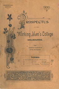
Book - Book - Prospectus, The Working Men's College Melbourne, Prospectus,1900, 1900
The Working Men’s College was founded in 1881 by a prominent grazier and philanthropist, The Hon. Francis Ormond, who donated £5000 towards the establishment of the college. The Council of the Melbourne Trades Hall then matched Ormond's initial donation by rallying its members. On 4 June 1887, the college opened in its purpose-built building on the corners of Bowen Street and La Trobe Street in Melbourne, with a gala ceremony. It became the third official provider of higher education in the new Colony of Victoria (the Melbourne Athenaeum was founded in 1839 and the University of Melbourne in 1853). The college was the predecessor to the current-day Royal Melbourne Institute of Technology (RMIT University). Adjoining the college in the 1890s were the Supreme Court of Victoria (later the Melbourne Magistrates' Court) and the Melbourne Gaol - both which are now part of RMIT today. A list of Scholarship Governors and Life Governors is included. The former have donated 250 Pounds Sterling and upwards, the later have donated 20 Pounds and over but less than 250 Pounds Sterling. The Patron of The Working Men's College was His Excellency The Right Honourable Lord Brassey. The President of the Council was Professor W C Kernot. The majority of classes were at night and on Saturdays. Tan soft covered book of 112 pages. The thirteenth edition of the Working Men's College (later Royal Melbourne Institute of Technology [RMIT]). It inlcudes the following photographic images: Main Building, Assaying, 1899 council (W.C. Kernot, W.H. Embling, Thomas smith, F.H. Bromley, John Reid, R.H. Solly, E. Findley, D. McIvor, James Robb, John Hancock, C.E. Oliver, A.J. Arnot, James Smith, Joseph Nixon, R.L.Jellery. C.S. Paterson), UNveiling the Ormond Statue, Victorian Lead and Shot Works, Francis Ormond, Telegraphy room, Lecture Theatre, photography, painting class, wool sorting, plumbing, Remington typewriter, W. Ison, H.D. Evans, library, Verdon prize, Denton Hat Mills. working men's college melbourne, rmit, w.c. kernot, w.h. embling, ormond statue, f. ormond, electricity, surveying, architecture, photography, assaying, dressmaking, veterinary science, plumbing, letterpress printing, w. ison, h.d. evans, library, denton hat mills, literary and commercial department, typewriting department, languages, telegraphy, department of music, department of mathematics, department of engineering, 'department of architecture, department of art and applied art, department of mining and metallurgy, department of chemistry, department of household economy, department of agriculture and rural industries, woodworking, carpentry and joinery, turning and fitting, coachbuilding and carriagedrafting -
Federation University Historical Collection
Letter, Letter from Department of Labour and National Service to EJ Barker Ballarat Institute of Advanced Education
... Letter from Department of Labour and National Service to EJ ...Ballarat Institute of Advanced Education is a predecessor of Federation UniversityLetter from Department of Labour and National Service to EJ Barker Ballarat Institute of Advanced Education regarding a meeting of the Chamber of Manufactueringdepartment of labour and national service, ballarat institute of advanced education, bruce tanner, laurie wilkie, kevin murray, brother stewart, alan williams, jack barker, h.t. ferguson -
 Linton and District Historical Society Inc
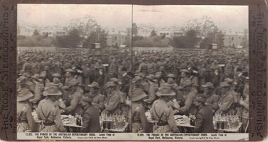
Stereograph, The Rose Stereographs, Melbourne, Sydney, Wellington and London, 12,922 Parade of the Expeditionary Force, Copyright 1914
... 12,922 Parade of the Expeditionary Force ...One of two sets of stereographs donated by the O'Beirne family along with a stereoscope for viewing (Stereoscope is Registration no. 2014-51).Large group of soldiers at Royal Park, Melbourne. Vehicles and buildings in background. Foreground has soldiers around a table with lots of bottles on it."12,922. THE PARADE OF THE AUSTRALIAN EXPEDITIONARY FORCE. Lunch Time at / Royal Park, Melbourne."stereographs, australian expeditionary force -
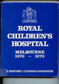 Alfred Hospital Nurses League - Nursing Archive
Book - Illustrated book, Lyndsay Gardiner, Royal Children's Hospital, Melbourne, 1870-1970: a history, 1970
History of the Royal Children's Hospital, Melbourne, from its foundation in 1870 until 1970.Illustrated book with dustjacket, book is bound in dark blue, with title and authors name printed in silver on spine. Dust jacket has a dark blue background with the title and author printed in white on the front. Also on the front is the RCH coat of arms printed in white.non-fictionHistory of the Royal Children's Hospital, Melbourne, from its foundation in 1870 until 1970.royal children's hospital (melbourne), hospitals-victoria-history -
 Federation University Historical Collection
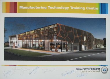
Photograph - Poster, University of Ballarat Manufacturing Technology Training Centre poster signed by Prime Minister Julia Gillard, 07/10/2011 (approx 11.15am)
... University of Ballarat Manufacturing Technology Training ...The new Manufacturing Technology Training Centre (MTTC), a part of the proposed Building Construction Training Centre (BCTC), will be a purpose-built, stand-alone, fully fitted-out industry-standard facility. This new space will accommodate current course provision along with specialist training spaces for developing skill requirements in manufacturing technology such as robotics, mechatronics, engineering and industrial automation. Project funding was provided by the Education Investment Fund from the Australian Government Department of Education, Employment and Workplace Relations. The project budget is $18.09m, and the resulting building will have a floor space of 4,755m2. The Manufacturing Technology Training Centre is being built in conjunction with the Technical Education Centre (UBTec). While the buildings will have separate street identities the buildings will be joined with shared amenities areas. UBTec will provide a facility including individual learning spaces, learning studios, administration/office space, circulation, open plan learning space, staff common areas, computer rooms, meeting rooms, staff work areas and kitchen areas as well as car parking and site-wide amenities. While the buildings will have separate street identities the buildings will be joined with shared amenities areas. Funding for the UBTec component of the building is provided by Maintaining the Advantage: Skilled Victorians from the Victorian State Government. A colour poster prepared for the 'turning of the sod' at the site of the proposed University of Ballarat Manufacturing Technology Training Centre (MTTC), Grant Street, Ballarat. The poster was signed on Friday 7 October 2011 at about 11:15 am at the Building Construction Training Centre (BCTC), Grant Street, Ballarat by: Hon. Julia Gillard MP Hon. Catherine King MP (Ballarat ) Prof. David Battersby, Vice Chancellor, University of Ballarat Mayor, Cr Craig Fletcher, Mayor of the City of Ballarat appointed in December 2010 Mrs. Karen Douglas, Chair University of Ballarat Building & Infrastructure Committee The poster is signed by the Prime Minister of Australia, the Hon. Julia Gillard MP; Karen Douglas; the Hon. Catherine King MP (Ballarat ); Prof. David Battersby (Vice Chancellor); Craig Fletcher (Mayor, City of Ballarat)university of ballarat, david battersby, julia gillard, prime minister, catherine king, ubtec, karen douglas, manufacturing technology training centre, grant street, architecural feature -
 Federation University Historical Collection
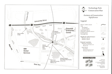
Document - Plan, Mathew Gibson, Centre for Environmental Management, Ballarat Technology Park Conservation Plan, 1997, 1997
The Ballarat Technology Park is on the Mount Helen Campus.A4 photocopy of a plan of the Ballarat Technology Park showing features of conservation significance. The plan includes the Canadian Creek, an historic hand-made brick culvert, Canadian Wetland Development, early wooden bridge, old path of the Ballarat-Buninyong Railway line, Greenhill Enterprise Centre and IBM Global Services.ballarat technology park, greenhill enterprise centre, ibm global enterprises, ballarat-buninyong railway line, canadian wetlands, brick railway culvert, canadian creek, riparian woodland, yarra gum, swamp gum, blackwood, remnant vegetation, scent bark, narrow-leaf peppermint, messmate, centre for environmental management, mount helen campus -
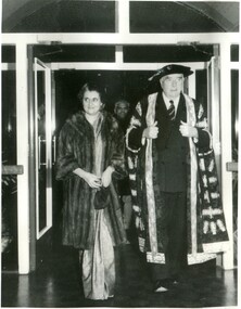 International House, The University of Melbourne
Photograph (Item), Prime Minister of India Indira Gandhi and Chancellor of the University of Melbourne Robert Menzies at the entrance to International House
... Prime Minister of India Indira Gandhi and Chancellor of the ...india, indira gandhi -
 Ballarat Heritage Services
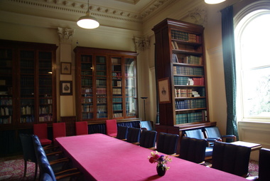
Photograph - Colour, Clare Gervasoni, Royal Society of Victoria Library, 2015, 27/11/2015
... Royal Society of Victoria Library, 2015 ...Colour photographs of the interior of the Royal Society of VIctoria, Melbourne.library, royal society of victoria -
Federation University Historical Collection
Document, R.T. Morrell, Letter from R.T. Morrell Business Manager of Ballarat Institute of Advanced Education, 20th July 1971
... Letter from R.T. Morrell Business Manager of Ballarat ...Ballarat Institute of Advanced Education is a predecessor of Federation University Typed letter from R.T. Morell Business Manager of Ballarat Institute of Advanced Education regarding travel allowance for Mrs L.M. Jardineballarat institute of advanced education, r.t. morrell, mrs l. m. jardine, travel allowance -
 Vision Australia
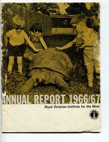
Administrative record - Text, Royal Victorian Institute for the Blind annual report 1966-1967, 1966-1967
Articles in annual report include: Office bearers of the institute/officers, President's report - 100 years, Residence nursery and school for blind children - in 1866 first nine blind children were accommodated in temporary premises in Commercial Road Prahran, the budget was $822 pounds, now the facility in Burwood can house 70 children and the, budget is $160,000, New found confidence after rehabilitation, Blind welfare work increases, Our factory now serves industry, Employ opportunities are widening, Our loyal auxiliaries and other supporters, What of the future, Income and expenditure, Where there's a will there's a way to help blind people. Events that occurred in 1966 : Millet broom making was discontinued and mat and industrial brush making and packing and assembly began, the Governor of Victoria and Lady Delacombe brought their dog to visit the children at the school, the Institute began two vital new projects - providing a residential geriatric facility and to establish the RVIB foundation for research and education.1 volume of print and illustrationsannual reports, royal victorian institute for the blind -
 Melbourne Tram Museum
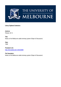
Document - Report, W. R. Pollock, University of Melbourne, "Notes on the Melbourne Cable Tramway System", 1928
... W. R. Pollock, University of Melbourne ...Digital copy of a paper presented to the Victorian Institute of Engineers in 1928 by W. R. Pollock. Paper looks at the tramway cables, with additional notes on the power and machinery required for the system. Includes notes on cable life, replacement, repairs, faults and renewal. Includes some discussion on the paper. Scanned by the University of Melbourne - downloaded 30-12-2016. First page gives the title, authors and url of the paper. It is word searchable.trams, tramways, melbourne, cable trams -
 Vision Australia
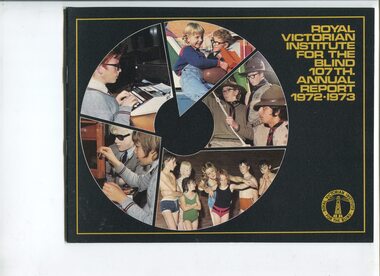
Administrative record - Text, Royal Victorian Institute for the Blind annual report 107th 1972-1973, 1970-1971
Articles in the annual report include: Burwood School acquiring a caravan to use as a mobile science lab, a Seminar on Rehabilitation for Employment was held, a profile of retiring President Charles Bennett who first joined a panel of doctors providing free services to blind people in 1931, became Honorary Medical Officer for the Institute in 1941 and President in 1951. Also included are articles on the Optacon, Carols by Candlelight and a small profile on Neil Westh.1 printed volume with photographsroyal victorian institute for the blind, annual reports -
 NMIT (Northern Melbourne Institute of TAFE)
Manual: Programs Manual NMIT, Programs Manual 1997. NMIT, 1997
This folder contains documents relating to internal organisation, policies and procedures of Northern Melbourne Institute of Technology. It includes organisational flowcharts and procedures for enrolment and planning of recurrent and customised programs and courses. This manual provides a snapshot of the responsibilities of both the organisation and staff in the 1990s.White loose leaf binder with blue insert in front cover. Contents include documents relating to internal organisation, policies and procedures of Northern Melbourne Institute of Technology.Typed insert in front cover indicates that this manual was from the Library Loans Desk.northern melbourne institute of technology, nmit, -
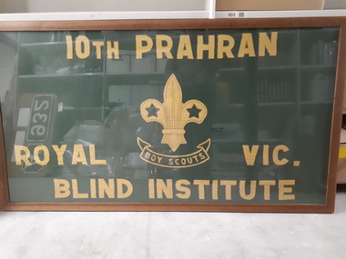 Vision Australia
Flag - Object, 10th Prahran Royal Blind Institute Boy Scouts flag
Framed green flag with yellow stitched writing (10th Prahran Boy Scouts Royal Blind Institute) and a stitched Boy Scout emblem in the centre. In 1921, the new superintendent (S. Hedger) introduce a new range of activities for the children at the school, including the development of a Scout group.Green flag with yellow stitching in frameroyal victorian institute for the blind, recreational activities