Showing 1812 items
matching shown
-
 Bacchus Marsh & District Historical Society
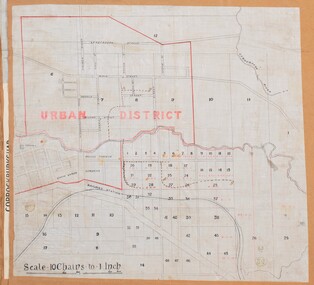
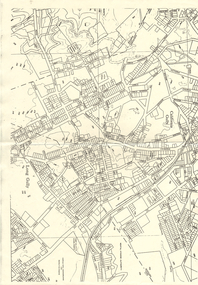
Map, Bacchus Marsh Urban District
The date of this map has not been established but the date would be sometime after 1887 as the Bacchus Marsh Railway Station, which opened in 1887, is shown on the map. A single page paper map showing blocks of land in the urban district of Bacchus Marsh. The 'urban district' is indicated by red drawn lines on the map and includes streets and blocks on the northern side of the Werribee River in Bacchus Marsh, and streets and blocks south of the Werribee in Maddingley. Scale 10 chains to 1 inch. The map is pasted into a bound volume containing 76 maps or plans in total. High resolution digital image stored on BMDHS computer network. bacchus marsh victoria maps, maddingley victoria maps -
 Phillip Island and District Historical Society Inc.
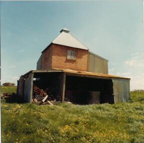
Photograph, 1978/79
The Chicory Kiln shown in the photograph is situated on land owned by the McIlwraith family in the 1870s. It is at Heath Hill on the Rhyll-Newhaven Road and is one of the oldest on Phillip Island.Coloured photograph showing a Chicory Kiln on the property which belonged to the McIlwraith family.local history, photographs, buildings - historical, housing, rural industry, coloured photograph, john cook, phillip island, mcilwraith homestead -
 Seaworks Maritime Museum
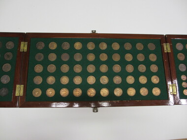
Coin Collection
100 coins areas shown in large wooden display case. Featuring Australian and English pennies some dating back to the 19th century. Also features a small plaque. Outside of case features two Melbourne Harbor Trust Crests. Accompanied by a handwritten card. -
 Federation University Historical Collection
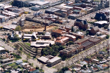
Photograph - Photograph - Colour, Aerial Photograph of the Ballarat School of Mines Campus, c1995
Colour aerial photograph of the Ballarat School of Mines campus. Albert street is shown on the lower right side and Grant Stret on the left. The M.B. John Building is present along Albert Street, the Ballarat Brewery has been demolished in preparation for the building of the Brewery Building. ballarat school of mines, aerial, m.b. john building, e.j. tippett library, corbould hall, brewery building, brew tower, brewery chimney, ballarat school of mines creche -
 Bendigo Historical Society Inc.
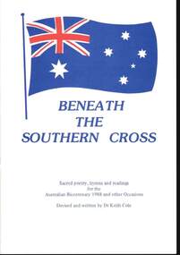
Book - BOOKLET: BENEATH THE SOUTHERN CROSS BY DR KEITH COLE
6 x copies -Glossy stapled paper Booklet 'Beneath The Southern Cross ' ' Sacred poetry , hymns and readings for the 1988 Australian Bicentenary and other Occasions Devised and written by by Dr Keith Cole - these details and the Australian flag shown on the front cover / 18 pagesDr Keith Colebook -
 Bendigo Historical Society Inc.
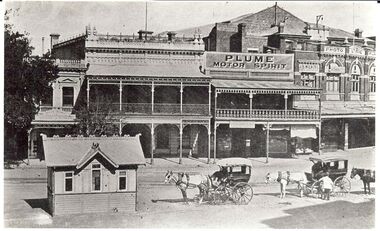
Photograph - BASIL MILLER COLLECTION: HORSEDRAWN CARRIAGES AT CHARRING CROSS
Black and white photographic copy, 2 Horsedrawn carriages at tram stop at Charring Cross. Lyric theatre shown top right. Original taken after 1913. Two horse drawn cabs with attendants. Small building. Advertising in background plume Motor Spirit.person, individual, basil miller -
 Port Melbourne Historical & Preservation Society
Photograph - Houses during construction on Dunstan Estate, Port Melbourne, Department of Public Works, 1936
Twenty five (25) black and white or sepia photographs of the houses of the Dunstan Estate during their building i.e. Griffin Crescent and Southwood Avenue .01 - sheet with 9 photos later enlarged as individual images Taken in 1936, some cars shown parked in streetsbuilt environment - domestic, domestic life, department of public works, dunstan estate, everett, percy e, pye, henry, dunstan, albert -
Port Melbourne Historical & Preservation Society
Photograph - Houses during construction on Dunstan Estate, Port Melbourne, Department of Public Works, 1936
Twenty five (25) black and white or sepia photographs of the houses of the Dunstan Estate during their building i.e. Griffin Crescent and Southwood Avenue .02 - sheet with 9 photos later enlarged as individual images Taken in 1936, some cars shown parked in streetspercy e everett, henry pye, albert dunstan, dunstan estate, department of public works, built environment - domestic, domestic life -
Port Melbourne Historical & Preservation Society
Photograph - Houses during construction on Dunstan Estate, Port Melbourne, Department of Public Works, 1936
Twenty five (25) black and white or sepia photographs of the houses of the Dunstan Estate during their building i.e. Griffin Crescent and Southwood Avenue .03 - sheet with 6 photos later enlarged as individual images Taken in 1936, some cars shown parked in streetsbuilt environment - domestic, domestic life, department of public works, dunstan estate, percy e everett, henry pye, albert dunstan -
 Port Melbourne Historical & Preservation Society
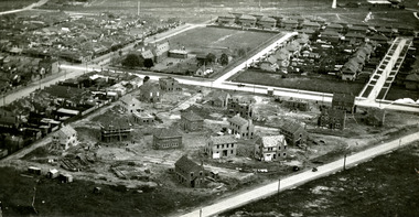
Photograph - Aerial view of houses during construction on Dunstan Estate, Port Melbourne, Department of Public Works, 1936
Twenty five (25) black and white or sepia photographs of the houses of the Dunstan Estate during their construction i.e. Griffin Crescent and Southward Avenue .04 - Aerial photographs (also shows Graham St School) Taken in 1936, some cars shown parked in streetsbuilt environment - domestic, domestic life, department of public works, dunstan estate, percy e everett, henry pye, albert dunstan -
 Bendigo Historical Society Inc.
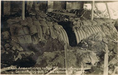
Postcard - ACC LOCK COLLECTION: ARMENTIERES AFTER GERMAN OFFENSIVE, GERMAN DUG-OUTS IN BASEMENT OF FACTORY, POSTCARD, 1914-1918
Postcard, B & W, WW1, destroyed German dug-outs in the basement of a factory at Armentieres after a German offensive. Sandbags shown over curved iron roof. Undated. Two copies. AZ22 and Z36 AZ22 copy published byJ.M.Hamilton & Coy. Sydney, Australia.postcard, postcard, ww1, armentieres, german dug-outs, j.m.hamilton & coy. -
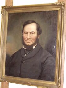 Stratford and District Historical Society
Portrait of Samuel Swan
This portrait is said to be in the technique of Alfred Bock, but the frame is dissimilar to the standard type on 80% of the collection in the Sale Museum. Samuel Swan died in 1880. It is unclear where the portrait hung, as Swan died before the Mechanics' Institute was built.An unsigned portrait, oil on canvas, of Samuel J Swan. He is shown looking left. It is framed in a gold coloured plaster frame, with relatively simple trimming on corners. The frame is chocked at the back with wooden wedges to hold canvas in place, and a framer's label appears at the top.'Samuel J Swan / Gippsland Pioneer' on brass plate bottom front. "Telephone 7231 Central / T.S. Glasier & Co Pty Ltd / Gallery of Art / Picture Frame Manufacturers &c / Union House / 284-6 Little Collins Street / No [in pencil] 2344, Melbourne" -
 Bendigo Historical Society Inc.
Map - LONG GULLY HISTORY GROUP COLLECTION: MAP OF LONG GULLY AREA
map of Long Gjully and California Gully area from Craig Street to Barrell Street. Indicators show location of the mental hygiene Austhority, Agricultural Showgrounds and Recreation Reserve. The boundary between the Borough of Eaglehawk and Bendigo is shown by a dotted line along McGowan Street.eaglehawk, history, street map long gully/california gully. -
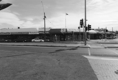 Lakes Entrance Regional Historical Society (operating as Lakes Entrance History Centre & Museum)
Photograph, 2008
Date made August 2008Colour photograph of the retail stores - Icecream Parlour, Stitches and Things, Lakes Photographics and King and Heath Real Estate - on the corner of Myer Street and Esplanade, the only traffic lights in the town also shown. The original site of St Rosieres Guesthouse. Lakes Entrance Victoriaguesthouses, retail trade, room display -
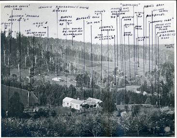 Mt Dandenong & District Historical Society Inc.
Photograph, "Kia-Ora' Guest House. Kalorama Valley c1900, c1900
Landscape view from Barbers Road across the valley. Kia-Ora was built by George Barber in 1909 and run as a guest house. John Lundy-Clarke annotated the properties shown with the owners' names. Excellent companion piece to J L-C's "Mountain of Struggle".kalorama valley, kia-ora guest house, mountain of struggle, john lundy-clarke -
 Kew Historical Society Inc
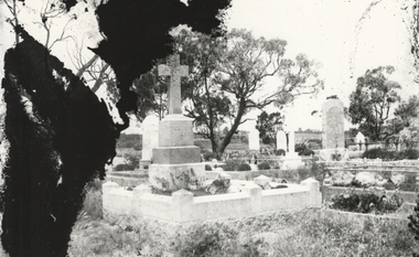
Photograph, Graves, St Kilda Cemetery, c.1925
This photograph was printed from a glass negative held in the Society's picture collection. The original glass negative is part of a set donated to the Society by Ian McKenzie, a professional photographer in Kew. Graves within a cemetery, post 1914. A photograph of graves in a cemetery. The photograph, of unknown provenance, is on the lower half of a glass negative. The upper half can be seen in PIC 0053. Given that the upper half is of a grave in Brighton Cemetery, it is possible that this is also the location shown in this photograph.st kilda cemetery, graves, glass negatives -
 Kew Historical Society Inc
Photograph - Yarra Valley Floods: Kew East, 1916
Flooding of the Yarra Valley, including that section of the Yarra bordering Kew and Kew East in the north and west of the municipality, was a regular occurrence. Extreme flood events of the Yarra River are recorded to have occurred in 1891, 1901, 1916, 1923 and 1934. The Municipality of Kew's response to these floods was to enact planning decisions restricting residential development in flood prone areas following the floods of 1916, 1921 and 1934. While floods continued after the development of the Upper Yarra Reservoir (construction 1948-57), the regularity and extent of these inundations diminished. During the nineteenth century, the land abutting the south side of the Yarra in Kew was devoted to dairy farming. In the twentieth century, before and after the construction of the Eastern Freeway, much of this low-lying area was used as golf courses and public parks.One of a collection of photographs of flooding in the Kew section of the Yarra Valley which are in important research resource for the location and extent of flooding in the first half of the twentieth century. Flooding of the Yarra Valley at East Kew in 1916. The view is taken from the intersection of Kilby Road with what is believed to be Birdwood Street, looking across the flood waters to Ivanhoe. The extensive flooded area shown in the photograph would have included the Kew Golf Club. Verso: "Floods along Kilby Road / near Birdwood St? & Kilby Road / 1917? / 87yarra river, yarra valley, floods -- kew, kilby road -- kew (vic.), kew golf club -
 Surrey Hills Historical Society Collection
Photograph, Streetscape near the corner of Victoria Crescent and Hotham Street, Surrey Hills
Prior to subdivision for housing this area was paddocks used for grazing of cattle and used as part of the course in the early days of the Surrey Hills Golf Club. Reproduced by permission of Mr John Arnold from his book: "The Riversdale Golf Club - a history, 1892-1977." Copyright to book: Riversdale Golf Club. Surrey Hills Golf Club operated from 1892-1908 then moved and became Riversdale Golf Club. The game was played across paddocks from Trafalgar Street, Mont Albert to Whitehorse Road and down Victoria Crescent to where Box Hill TAFE is now located in Elgar Road. There were problems with cows eating the tee flags! The clubhouse still exists as 30 Trafalgar Street.Black and white photo taken from the centre of a bitumen road which is flanked by bluestone guttering. Nature strips, drive cross-overs and house fences are shown. Trees on the RHS nature strip are pollarded to avoid overhead power and telephone lines. There houses in the background."Bottom: The same view today taken from the intersection of Victoria Crescent and Hotham Street, Surrey Hills."surrey hills golf club, hotham street, victoria crescent, riversdale golf club, surrey hills, john arnold -
 Lakes Entrance Regional Historical Society (operating as Lakes Entrance History Centre & Museum)
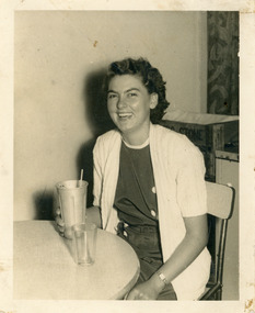
Photograph - Darcy, 1980
Black and white photograph of Margaret Mary Darcy aged 18 years 10 months on the day she was named Miss Lakes Entrance. She is shown in dark frock and short sleeved cardigan seated at a cafe table holding a milksahake, Lakes Entrance Victoriagenealogy, celebration -
 Lakes Entrance Regional Historical Society (operating as Lakes Entrance History Centre & Museum)
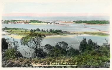
Postcard - Bullock Island, Bulmer H D, 1920c
Hand coloured postcard of Bullock Island and the man made entrance from Bass Strait to the Gippsland Lakes. Also shown the small township, unofficially known as Carpentertown at the entrance works. Photo taken from Kalimna Hill, shrubbery in foreground. Lakes Entrance VictoriaBullock Island, Lakes Entrancewaterways, bridges, islands, jetties -
 Port of Echuca
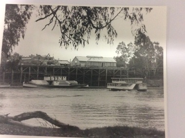
Photograph - Two black and white photographs, 20/09/1984
These photographs show the extent of the Echuca Wharf in 1984. They also the cargo shed, the Echuca Wharf Railway Station. The P.S Pevensey and P.S Pride of the Murray are also shown.These photographs show the state of the wharf in the 1980,s.2 black and white photographs of the Echuca wharf. One is a closer version of the other. The photograph shows the P.S Pevensey tied up at the wharf with the P.S Pride of the Murray passing upstream. On the paddle steamers The words " Pevensey " and "Pride of the Murray " can be seen. In the background part of the Shackell's bond store inscription can be seen. echuca wharf, p.s pevensey, p.s.pride of the murray, shackell's bond store, rosel, mike -
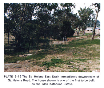 Eltham District Historical Society Inc
Work on paper (Sub-Item) - Photograph, St Helena East drain immediately downstream of St Helena Road
Colour photograph of St Helena East drain immediately downstream of St Helena Road, Greensborough. The house shown is one of the first to be built on the Glen Katherine Estate.eltham, drain, st helena, glen katherine estate, greensborough -
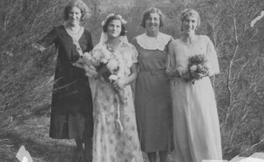 Greensborough Historical Society
Photograph - Digital image, A make believe wedding, 1932c
In this photograph, members of the Partington family dress up for a 'make-believe wedding'. Shown are Eva Partington, Wyn Partington (nee Leed), Grace Partington and Jessie Partington.Digital copy of black and white photograph.partington family, wyn partington, wyn leed, grace isobel partington, eva partington, jessie partington -
Tatura Irrigation & Wartime Camps Museum
Photograph, Daryl Walker, Tatura Community Playground, 1986
Tatura Community playground is part of the primary school play area. Exterior of school is shown through trees. Built by prisoners from Dhurringile Prison and other volunteersBlack and white photograph of playground situated in grounds of Tatura Primary School, built 1969.on back: Tatura Community playground (at primary school) 1986.tatura community playground -
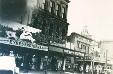 City of Ballarat Libraries
Photograph, Sturt Street Centenary Celebrations 1938
Sturt Street during the Centenary Celebrations in 1938. You can see decorations on the Eyre Bros building. Other businesses shown are Sutton's Boot Palace and Whiteside's.sturt steet, centenary, ballarat, eyre bros, sutton's boot palace, whiteside's, decorations -
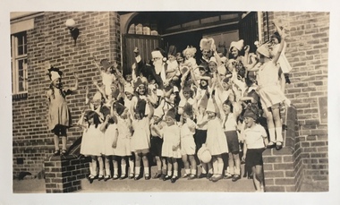
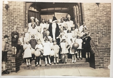 Kew Historical Society Inc
Photograph - St Hilary's Church Christmas Party, c.1932
St Hilary's Anglican Church in Kew was established in 1888 on land granted to the congregation by the Dumaresq family. The brick building shown here replaced an earlier wooden structure.Small black and white photographic positive, one of four, of a Christmas party for children at St Hilary's Church, 12 John Street, Kew. The children, surrounding an adult Santa Claus, are dressed in festive costumes and a number carry balloons. The foundation plaque is on the wall to the children's left. The photo was tentatively dated to 1932 by the donor. Inscribed verso: "St Hilary's Christmas Party ?1932"churches -- kew (vic.), st hilary's church -- kew, anglican churches -- melbourne (vic.) -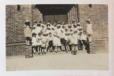
 Kew Historical Society Inc
Photograph - St Hilary's Church Christmas Party, c.1932
St Hilary's Anglican Church in Kew was established in 1888 on land granted to the congregation by the Dumaresq family. The brick building shown here replaced an earlier wooden structure.Small black and white photographic positive, one of four, of a Christmas party for children at St Hilary's Church, 12 John Street, Kew. The children, surrounding an adult Santa Claus, are dressed in festive costumes and a number carry balloons. The photo was tentatively dated to 1932 by the donor. Inscribed verso: "St Hilary's Christmas Party ?1932"churches -- kew (vic.), st hilary's church -- kew, anglican churches -- melbourne (vic.) -
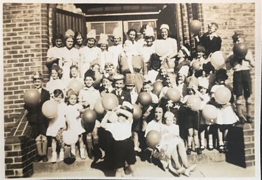
 Kew Historical Society Inc
Photograph - St Hilary's Church Christmas Party, c.1932
St Hilary's Anglican Church in Kew was established in 1888 on land granted to the congregation by the Dumaresq family. The brick building shown here replaced an earlier wooden structure.Small black and white photographic positive, one of four, of a Christmas party for children at St Hilary's Church, 12 John Street, Kew. The children are formally dressed with most wearing hats. The photo was tentatively dated to 1932 by the donor. Inscribed verso: "1932 St Hilary's Christmas Party"churches -- kew (vic.), st hilary's church -- kew, anglican churches -- melbourne (vic.) -
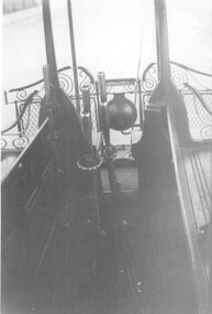 Melbourne Tram Museum
Photograph, Gripman's view forward
The photograph shows the view of a gripman looking forward with his levers, the longitudinal seats and the head light. Also shown is the seat in the opposite corner of the grip car or dummy.Yields information about cable trams in the 1920s and 1930s.Photograph, black and white, plain backtrams, tramways, cable tram, gripmen, grip tram, dummy