Showing 1873 items matching "subdivision"
-
 Whitehorse Historical Society Inc.
Letter - Correspondence, Abattoir Property, 1937
Letters between City of Box Hill and Shire of Blackburn and Mitcham re sale of abattoir property with a plan of the subdivision.Letters between City of Box Hill and Shire of Blackburn and Mitcham re sale of abattoir property with a plan of the subdivision.Letters between City of Box Hill and Shire of Blackburn and Mitcham re sale of abattoir property with a plan of the subdivision.city of box hill, shire of blackburn and mitcham, abattoirs paddock, aspinall's estate, woodhouse grove, box hill north, aspinall road, box hill north, koonung creek, land subdivision -
 Whitehorse Historical Society Inc.
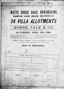
Document, Hampton Court Estate
Plan of subdivision Hampton Court EstatePlan of subdivision Hampton Court Estate Whitehorse Road, Nunawading 1882. Original in Vale Maps LaTrobe LibraryPlan of subdivision Hampton Court Estate hampton court estate, byrne vale & co. -
 Whitehorse Historical Society Inc.
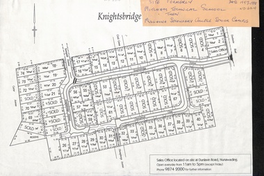
Map, Knightsbridge Estate, Nunawading, Ca 1997 - 1998
Plan of subdivision of former Mitcham Technical School and later Mullauna Secondary College Senior Campus - Knightsbridge Estate.land subdivision, knightsbridge estate, mitcham technical school, mullauna secondary college, senior campus, cherrybrook close, nunawading, knightsbridge avenue, sunnyside avenue, crest grove, dunlavin road, mitcham, carter avenue, humphreys avenue -
 Brimbank City Council
Ledger, City of Keilor Ledger
City of Keilor Ledger - subdivisions, town works, water works, construction etc. Blue colour hard cover. -
 Kew Historical Society Inc
Plan - Subdivision Plan, Glenferrie Road & Wellington St, Kew, c.1920s
Subdivision plans are historically important documents used as evidence of the growth of suburbs in Australia. They frequently provide information about when the land was sold on which a built structure was subsequently constructed as well as evidence relating to surveyors and real estate and financial agents. The numerous subdivision plans in the Kew Historical Society's collection represent working documents, ranging from the initial sketches made in planning a subdivision to printed plans on which auctioneers or agents listed the prices for which individual lots were sold. In a number of cases, the reverse of a subdivision plan in the collection includes a photograph of a house that was also for sale by the agent. These photographs provide significant heritage information relating house design and decoration, fencing and household gardens.An unnamed subdivision in Kew including eleven lots for sale bordering Glenferrie Road, Wellington Street and Franks Grove.subdivision plans - kew, franks grove, wellington street, glenferrie road -
 Ringwood and District Historical Society
Document - Map, Part of Crown Allotment 27C, Parish of Warrandyte, County of Evelyn, Ringwood, Victoria - c.1970
Photocopy of subdivision plan 75131 Vol 3439 Fol 712 showing numbered residential allotments with property dimensions.Surveyors and Consulting Engineers - O'Connor & Beveridge, Main Eltham Road, Lower Plenty, Tel. 432668. Rubber-stamped "Photocopy - Titles Office Complied 17 Feb 1970". Map includes Lockhart Road, Lansell Close, Terrara Place, Goldsmith Avenue, Park Hill Drive, Hilldale Close, and Elm Court, Ringwood, Victoria. -
 Kew Historical Society Inc
Plan - Subdivision Plan, Mount Ida Estate, 1925
The Kew Historical Society collection includes almost 100 subdivision plans pertaining to suburbs of the City of Melbourne. Most of these are of Kew, Kew East or Studley Park, although a smaller number are plans of Camberwell, Deepdene, Balwyn and Hawthorn. It is believed that the majority of the plans were gifted to the Society by persons connected with the real estate firm - J. R. Mathers and McMillan, 136 Cotham Road, Kew. The Plans in the collection are rarely in pristine form, being working plans on which the agent would write notes and record lots sold and the prices of these. The subdivision plans are historically significant examples of the growth of urban Melbourne from the beginning of the 20th Century up until the 1980s. A number of the plans are double-sided and often include a photograph on the reverse. A number of the latter are by noted photographers such as J.E. Barnes.The Mount Ida Estate was a subdivision of fifty-two residential allotments bordering Tooronga Road, Leura Grove, Constance Street, and Mount Ida Avenue in Hawthorn East. The report of the sale of the Estate in The Argus (21 September) claimed that over 1,000 people attended the auction and that all allotments were sold on the day. On the other side of Constance Street, the plan identifies the ‘Eastern Recreation Reserve’ (now Anderson Park).subdivision plans - hawthorn -
 City of Kingston
Pamphlet - Black and white, Stott & Burke, Highland Estate Bentleigh, c.1915
Sales plan for land in the suburb of Bentleigh, along Collins and Ross Streets, bounded by Jasper Road.The developing urban area of Bentleigh within the City of Kingston. This land sale pamphlet illustrates the subdivision of land within the municipality and the changing demographic of the district as new houses are constructed.Black and white pamphlet advertising for private sale the Highland Estate, Bentleigh. Incorporates a map of the estate between Collins St and Ross St, bordered by Japser Road. Handwritten in grey pencil on map: additional subdivisions numbered 15-19 drawn along Ross St Handwritten in grey pencil on map: indecipherable annotations to subdivisions 1, 3 and 14land sales, bentleigh, estate -
Whitehorse Historical Society Inc.
Legal record - Land Title, Musk Street, Blackburn
Land Titles referring to No. 1 Musk Street, BlackburnLand Titles referring to No. 1 Musk Street, Blackburn : 1. Vol. 542 Fol. 108222, James William Barnes, 1872; 2. Vol. 1877, Fol. 375367, Freehold Investment and Banking Company of Australia Limited, 1886; 3. Transfer 1507851 to John Thomas Williams, 1932; 4. Vol. 8109 Fol. 997 William Henry Rogers, 1955, with Plan of Subdivision CP 21670; 5. cadastral map, AMA zone 55, Sep 2000.Land Titles referring to No. 1 Musk Street, Blackburn musk street, blackburn, no. 1, maple street, blackburn, lawson street, blackburn, elder street, blackburn, barnes, james william, freehold investment and banking company of australia ltd, springfield road, blackburn, whitehorse road, blackburn, barnes estate -
 Federation University Historical Collection
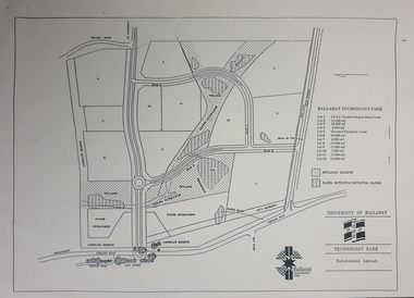
Plan - map, Ballarat Technology Park Wetlands Reserve and water retention basins, c1999
Yellow A4 page with a subdivision layout of the Ballarat Technology Park. It shows the Canadian Wetlands Researve and the water retentino.Detention Basins.canadian wetlands, ballarat technology park, mount helen campus -
Ringwood and District Historical Society
Legal record - Conditions of Sale (C.E.Carter), Mitcham - Crown Allotment 124. M.E.Burke to ? Dated June 1st 1929
Particulars and Conditions of Sale of Property , Lot 44 and 45 on Plan of Subdivision 6736, Mitcham Road, Mitcham. Mrs M.E.Burke to ? -
Whitehorse Historical Society Inc.
Legal record - Document, Certificate of Title, 28/10/1913 12:00:00 AM
Certificate of Title for Lot 41, Plan of Subdivision no. 2525, Deakin Street Mitcham, owned by State Savings Bank of Victoria.Certificate of Title for Lot 41, Plan of Subdivision no. 2525, Deakin Street Mitcham, owned by State Savings Bank of Victoria.Certificate of Title for Lot 41, Plan of Subdivision no. 2525, Deakin Street Mitcham, owned by State Savings Bank of Victoria.deakin street mitcham, state savings bank of victoria -
Whitehorse Historical Society Inc.
Article, Our changing landscape, 1986
Article re Tally Ho farm property on Burwood Highway. In 1986 Nunawading's high tech park subdivision will commence.Article re Tally Ho farm property on Burwood Highway. In 1986 Nunawading's high tech park subdivision will commence.Article re Tally Ho farm property on Burwood Highway. In 1986 Nunawading's high tech park subdivision will commence.land subdivision, tally ho -
Whitehorse Historical Society Inc.
Legal record - Land Title, Certificate of Title, 1974 - 1998
Certificate of Title: Vol 09048, Fol 467 Lot 1, Plan of Subdivision 113045, 64 Quarry Street, MitchamCertificate of Title: Vol 09048, Fol 467 Lot 1, Plan of Subdivision 113045, 64 Quarry Street, MitchamCertificate of Title: Vol 09048, Fol 467 Lot 1, Plan of Subdivision 113045, 64 Quarry Street, Mitchamquarry road, mitcham, no 64, land titles, mcclare, john, the glade, robertson, susan jayne, peter-budge -
Whitehorse Historical Society Inc.
Legal record - Land Title, Certificate of Title, 1925 - 1990
Certificate of Title. 36 Burnett Street, Mitcham. Vol 4991 Fol 998076 being Lot 21 of Subdivision No 6626.Certificate of Title. 36 Burnett Street, Mitcham. Vol 4991 Fol 998076 being Lot 21 of Subdivision No 6626.Certificate of Title. 36 Burnett Street, Mitcham. Vol 4991 Fol 998076 being Lot 21 of Subdivision No 6626.burnett street, mitcham, no 36, land titles, thomas street, green, david hamilton -
Whitehorse Historical Society Inc.
Article, A win for all in give and take, 1990
Article about the conclusion reached through negotiation between land developers and residents of Vermont over subdivision of Wunderlich landArticle about the conclusion reached through negotiation between land developers and residents of Vermont over subdivision of Wunderlich landArticle about the conclusion reached through negotiation between land developers and residents of Vermont over subdivision of Wunderlich landrooks road vermont, mitcham road vermont, land subdivision, wunderlich limited -
Whitehorse Historical Society Inc.
Newspaper - Article, History buff fights for homestead, 3/08/1994
Keith Rooney's appeal against subdivision proposal for 'Harwood' homestead comprising 1903 house and original earlier stables and coolroom.blackburn, edwardian style, rooney, keith, harwood, junction road, blackburn north, nos. 17-21, land subdivision -
Whitehorse Historical Society Inc.
Document, Title to 59 Mount Pleasant Road Nunawading, 1871 - 1992
Copies of Title documents for Lot 3, Plan of Subdivision 18705 for Section 117b, Parish of Nunawading from 1871 to 1992.Copies of Title documents for Lot 3, Plan of Subdivision 18705 for Section 117b, Parish of Nunawading from 1871 to 1992.Copies of Title documents for Lot 3, Plan of Subdivision 18705 for Section 117b, Parish of Nunawading from 1871 to 1992.mount pleasant road, nunawading no. 59, land titles, jones, dan, jones, anne -
Canterbury History Group
Book, Nicholson, Nancy and Maling Charles, Notes on J.B.Maling, First Mayor of Camberwell
Compilation of notes on the life of John Butler Maling, first Mayor of Camberwell, and the subdivision of J.B.Maling's Paddock, Whitehorse Road, Balwyn.canterbury, camberwell, balwyn, maling family, nicholson> nancy, j.b.malings paddock, land subdivision -
Federation University Historical Collection
Plan, Plan of Mount Helen, 7/7/1964
John [Jack] and Jessie Imogene[ Gene] Chatham purchased a subdivided property in Mount Helen. Chatham Ave Plan of Subdivisions to Mount Helen, Shire of Buninyong, Sheet 1 and Sheet 2 Scale 200 feet to one inchmidland highway, gear avenue, eddy avenue, shire avenue, boak avenue, moss avenue, rathkeale avenue, ingliston avenue, chatham avenue, mardango drive, nyora grove, yarana drive, shakespeare avenue, marina avenue, landale avenue, lylia avenue, recreation road, olympic avenue, the gums, heather avenue, dallas avenue, jones avenue, sebastopol mount clear road -
 Kew Historical Society Inc
Plan - Subdivision Plan, Belford Heights Estate, Kew, ca. 1925
Pru Sanderson, in her groundbreaking ‘City of Kew Urban Conservation Study : Volume 2 - Development History’ (1988), summarised the periods of urban development and subdivisions of land in Kew. The periods that she identified included 1845-1880, 1880-1893, 1893-1921, 1921-1933, 1933-1943, and Post-War Development. These periods were selected as they represented periods of rapid growth or decline in urban development. An obvious starting point for Sanderson’s groupings involved population growth and the associated economic cycles. These cycles also highlighted urban expansion onto land that was predominantly rural, although in other cases it represented the decline and breakup of large estates. A number of the plans in the Kew Historical Society’s collection can also be found in other collections, such as those of the State Library of Victoria and the Boroondara Library Service. A number are however unique to the collection.The Kew Historical Society collection includes almost 100 subdivision plans pertaining to suburbs of the City of Melbourne. Most of these are of Kew, Kew East or Studley Park, although a smaller number are plans of Camberwell, Deepdene, Balwyn and Hawthorn. It is believed that the majority of the plans were gifted to the Society by persons connected with the real estate firm - J. R. Mathers and McMillan, 136 Cotham Road, Kew. The Plans in the collection are rarely in pristine form, being working plans on which the agent would write notes and record lots sold and the prices of these. The subdivision plans are historically significant examples of the growth of urban Melbourne from the beginning of the 20th Century up until the 1980s. A number of the plans are double-sided and often include a photograph on the reverse. A number of the latter are by noted photographers such as J.E. Barnes.The Belford Heights Estate was a subdivision in Kew East, even though the title of the plan indicates that it was located in Kew. The subdivision had been approved by 1915, and included 105 lots facing Strathalbyn, Kitchener, Hamilton and Beresford Streets, as well as Balfour and Belford Roads. Those lots hand coloured with red probably represent blocks that had been sold. The additional information provided on the plan is also of interest. The plan includes the original location of East Kew State (Primary) School in Strathalbyn Street, which opened in 1892. The inset Locality Plan also includes the route of the Outer Circle Railway and the location of the Wilsmere and East Kew Stations. The location of the landmark Harp of Erin Hotel is also marked on the Locality Plan.belford heights estate, subdivision plans - kew -
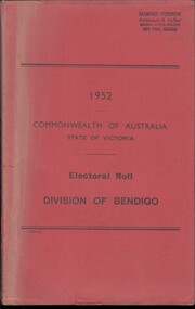 Bendigo Historical Society Inc.
Administrative record - Electoral Roll, 1915
Voting registers, or electoral rolls, are a census of those who were eligible to vote. They are valuable because a country-wide census was not taken until 1911. Early electoral rolls give an individual name, residence, status of property occupation/ownership, and the rate value of the property. Electoral rolls are arranged by electoral district and subdistrict. Name, Address, Occupation and gender for thirteen subdivisions (Bendigo, Carisbrook, Castlemaine, Eaglehawk, Elmore, Golden Square, Heathcote, Maldon, Marong, Maryborough, Raywood, Sandhurst East & Strathfieldsaye). Electoral rolls were published by each state during election years..Electoral Roll for the Commonwealth Division of Bendigo, State Assembly District of Bendigo, and State Electoral Province of Bendigo for 1952 (made up to 8th September 1952). Includes Name, Address, Occupation and gender for thirteen subdivisions (Bendigo, Carisbrook, Castlemaine, Eaglehawk, Elmore, Golden Square, Heathcote, Maldon, Marong, Maryborough, Raywood, Sandhurst East & Strathfieldsaye). Assembled and bound with string, and a red light-card cover.Stamped on cover as owned by Harold Curnow, Accountant and Auditor, Colonial mutual Building, View Street, Bendigo.electoral rolls, voting in bendigo -
 Ringwood and District Historical Society
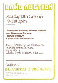
Document - Folder, Land Auction - Peacock's Estate, Waterloo Street, Heathmont, Victoria - 1973
Photocopy of Certificate of Title and double sided bi-fold leaflet advertising auction of 14 allotments on 13th October 1973 with map of streets, summary of local services and terms of sale. Subdivision includes Waterloo Street, Burns Road (later Dirkala Avenue), and Simpsons Road (later Simpsons Court). Auctioneers - C.E. Carter & Son R.E.S.I. 126 Whitehorse Road, Ringwood, Telephone 870 2519, 870 6830, 870 6024, A.H. 870 0421, 870 3568.Auctioneer's notation of sale prices included on brochure - all sold on day of auction. Vendor Frank Harry Peacock, Tile Burner, named as proprietor of Lot 12 on Plan of Subdivision No. 95654 on Title (Vol 8999 Fol 058). Map shows Dandenong Creek Watercourse as at September, 1971, prior to Dandenong Creek Trail development. -
 Ringwood and District Historical Society
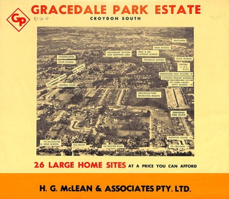
Flyer, Land Sale Brochure, Gracedale Park Estate, Croydon South, Vic. circa 1968
Although the brochure advertises Gracedale Park Estate as Croydon South, the home sites and streets are in the 3135 postcode area, i.e. Ringwood East/Heathmont.Bi-folded orange coloured sheet with black print advertising sale of residential allotments, including subdivision features and local facilities.Sudivision includes Ringwood East streets - Gracedale Avenue and Raymond Court. Agent - H.G. McLean & Associates Pty. Ltd., 166 Canterbury Road, Heathmont. Telephone 870 3422, A/Hours 870 5879, 729 2809. -
Glenelg Shire Council Cultural Collection
Administrative record - Plans, n.d
Black and white photocopy of old plan of subdivision, same as 8398, 8399, smaller scale, numerous notations, added by Vanda Savill. -
Whitehorse Historical Society Inc.
Map, Parkmore Nunawading, c1958
Subdivision plan of Parkmore Estate, Forest Hill using lot numbers.Subdivision plan of Parkmore Estate, Forest Hill using lot numbers. Advertised as a 'complete' community development by Southern Construction Company.Subdivision plan of Parkmore Estate, Forest Hill using lot numbers. parkmore estate, forest hill, parkmore road, forest hill, ranfurlie road, forest hill, quentin street, forest hill, oberon street, forest hill, cherryl street, forest hill, deauville street, forest hill, everglade avenue, forest hill, inglewood avenue, forest hill, cedar court, forest hill, martin court, forest hill, wandin court, forest hill, ranfurlie court, forest hill, hampshire road, forest hill, vanbrook street, forest hill, husband road, forest hill, ashmore road, forest hill, brentford square shopping centre, forest hill, sherman street, forest hill, sylvan court, forest hill, briarfield court, forest hill, yardley court, forest hill, wingrove street, forest hill, jolimont road, forest hill, wembley court, forest hill, longbrae avenue, forest hill, longbrae court, forest hill, teal court, forest hill, marleigh street, vermont, unley court, vermont, irving court, vermont, irving court, vermont, lexington street, vermont, ferncroft street, vermont, southern construction company -
 Whitehorse Historical Society Inc.
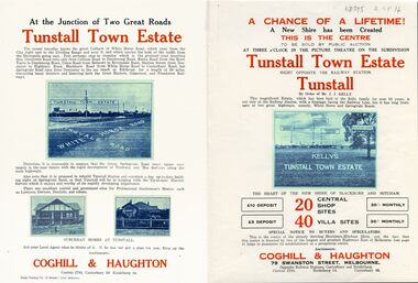
Legal record - Document, Tunstall Town Estate
Land subdivision at Tunstall 1926 bounded by Springvale Road, Whitehorse Road, Railway Parade.Land subdivision at Tunstall 1926 bounded by Springvale Road, Whitehorse Road, Railway Parade. Original in Haughton Maps LaTrobe LibraryLand subdivision at Tunstall 1926 bounded by Springvale Road, Whitehorse Road, Railway Parade. land subdivision, springvale road, nunawading, railway parade, kelly, j, nunawading state school, no. 4190, shire of blackburn and mitcham, whitehorse road, silver grove, glendale street -
Whitehorse Historical Society Inc.
Legal record - Land Title, Blackburn
Plan of subdivision of part of Crown Portions 81,92 and 89, Parish of Nunawading, County of Bourke. Photograph produced 11 Aug 1947.Plan of subdivision of part of Crown Portions 81,92 and 89, Parish of Nunawading, County of Bourke. Photograph produced 11 Aug 1947.Plan of subdivision of part of Crown Portions 81,92 and 89, Parish of Nunawading, County of Bourke. Photograph produced 11 Aug 1947.blackburn road, blackburn, wellington avenue, central road, gordon crescent, wolseley crescent -
 Whitehorse Historical Society Inc.
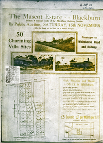
Document, Mascot Estate Blackburn
Subdivision of landSubdivision of land surrounded by Whitehorse Road, Simla street and King Street. 50 villa sites auctioned by M.Pullyn & Frank FisherSubdivision of land land subdivision, mascot estate blackburn, whitehorse road, blackburn, iona street, king street, simla street, pullyn, m, frank fisher & co. -
 Whitehorse Historical Society Inc.
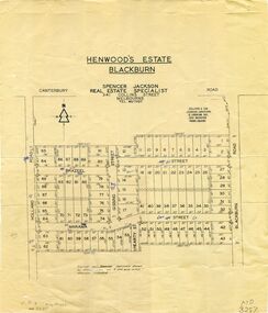
Map, Henwoods Estate, Blackburn
Plan of subdivision in Blackburn SouthPlan of subdivision in Blackburn South between Holland Road and Blackburn Road. Estate advertised by Spencer Jackson, 341 Collins Street.Plan of subdivision in Blackburn South land subdivision, henwoods estate, blackburn south, holland road, brazeel street, marama street, blackburn road, gissing street, hearty street