Showing 2423 items
matching township
-
 Lakes Entrance Regional Historical Society (operating as Lakes Entrance History Centre & Museum)
Book, Butler, Graeme, Port Albert, 1982
A study of the buildings and historical sites of the Alberton Shire, Victoria. Illustrated with photograps and diagrams.township -
Lakes Entrance Regional Historical Society (operating as Lakes Entrance History Centre & Museum)
Photograph, 1895
Downstream from bridge a steamer shown at the Bairnsdale wharf and Phoenix Foundry among wharf buildingsBlack and white photograph showing two rowing boats each containing three people, above Mitchell River bridge Bairnsdale Victoriatownship -
Lakes Entrance Regional Historical Society (operating as Lakes Entrance History Centre & Museum)
Photograph, M Fish, 1970
These hop kilns have since been destroyed by fire. Jubler was Architect of building, John French and Co Contractors. BNuilt for James Taylor in 1882 Madres Field Hop KilnsColour photograph of Hop Kilns on Silt Jetties Road east side of Mitchell River Bairnsdale Victoriatownship -
Lakes Entrance Regional Historical Society (operating as Lakes Entrance History Centre & Museum)
Postcard, Nancy Studio Bankstown NSW, 1950 c
Black and white postcard of Mrs Pearl Fallshaw nee Roadknight with son Malcolm and another unidenified man Bankstown NSWtownship -
Lakes Entrance Regional Historical Society (operating as Lakes Entrance History Centre & Museum)
Photograph, 1920 c
Black and white photograph of thirteen tourists in open motor boat tourist ferry Lakes Entrance Victoriatownship -
Lakes Entrance Regional Historical Society (operating as Lakes Entrance History Centre & Museum)
Postcard, 1910 c
Black and white postcard showing view of Reeves channel looking west toward Metung west end of Rigby and Fraser Islands mouth of Maringa creek lower right with neat mill workers cottages on flat Lakes Entrance Victoriatownship -
Lakes Entrance Regional Historical Society (operating as Lakes Entrance History Centre & Museum)
Postcard
Also another black and white photograph of same scene different angle crop of maize shown, boat on river possibly PS TanjilSepia toned photograph of view across the Tambo River looking eastward from Stephensons Road corner of Riversdale farm on right Redenback House in distance Swan Reach to Bruthen road shown with rinbarked trees on hill Tambo Upper Victoriatownship -
Lakes Entrance Regional Historical Society (operating as Lakes Entrance History Centre & Museum)
Book, Moruya and District Historical Society, You name it! Helpful Hints for Editors and Publishers of Journals, Reports and other serial Publications
A booklet presenting a pictorial history of Moruya and District New South Walestownship -
Lakes Entrance Regional Historical Society (operating as Lakes Entrance History Centre & Museum)
Photograph, Lakes Post Newspaper, 1/09/1993 12:00:00 AM
Flooding due to inadequate drainage, it soon went down.Black and white photograph showing flooding on Esplanade west of Myers Street intersection, businesses in photograph Pinochio Pizzaria, Lakes Auto Parts, Arjus Pizza, Bait and Tackle and Mobil Service Station on opposite corner Lakes Entrance Victoriatownship -
Lakes Entrance Regional Historical Society (operating as Lakes Entrance History Centre & Museum)
Photograph, M Holding, 1/11/1999 12:00:00 AM
Colour photograph of the Village Green showing flag at half mast on memorial cairn Metung Victoriatownship -
Lakes Entrance Regional Historical Society (operating as Lakes Entrance History Centre & Museum)
Photograph, Lakes Post Newspaper, May 1994
Black and white photograph of Metung Village Singers named are Bridie Christie, John Trotter, Wilma Jennings Allan Trevorrow Dorothy Trevorrow Metung Victoriatownship -
Lakes Entrance Regional Historical Society (operating as Lakes Entrance History Centre & Museum)
Postcard, H D Bulmer, 1930 c
Black and white postcard of a general view of town taken from railway station, Bruthen Hotel top right background, railway crossing lower right, Bruthen VictoriaGeneral View Bruthentownship -
Lakes Entrance Regional Historical Society (operating as Lakes Entrance History Centre & Museum)
Postcard, 1910 c
Also another black and white photograph enlarged to 16.5 x 25 cm 04491.1Sepia toned postcard of early Bruthen showing main street going left to right with Commercial bank seen in centre Bruthen Victoriatownship -
Lakes Entrance Regional Historical Society (operating as Lakes Entrance History Centre & Museum)
Photograph, 1922
Also an enlarged copy 18.5 x 25.5 cm 04493.1Black and white photograph of Dukes Bruthen Inn with two cars in front, 1920's models, one with six ladies on board, spare tyer on running board. Bruthen Victoriatownship -
Lakes Entrance Regional Historical Society (operating as Lakes Entrance History Centre & Museum)
Postcard
Black and white postcard showing a section of the Alpine Road the route from Omeo to Bright across the High Countrytownship -
Lakes Entrance Regional Historical Society (operating as Lakes Entrance History Centre & Museum)
Postcard, Bulmer, 1930 c
Two similar photographs of Bairnsdale gardens 04584.1 and 04584.2 6 x 9 cm Main Street Gardens Bairnsdale and Main Street Gardens and Rotunda Bairnsdale on backBlack and white postcard with photograph of early Main Street gardens showing winding footpaths and palm trees and water tower and cenotaph in background Bairnsdale Victoriatownship -
Lakes Entrance Regional Historical Society (operating as Lakes Entrance History Centre & Museum)
Photograph, K Scarce, 1984
Also colour photograph of two men on horseback passing rotunda during street parade Bairnsdale 04586.1 10 x 15 cmColour photograph showing two girls wearing winners sashes with driver in horse drawn vehicle passing rotunda during street parade at Bairnsdale Victoriatownship -
Lakes Entrance Regional Historical Society (operating as Lakes Entrance History Centre & Museum)
Photograph, 1910 c
Black and white photograph showing four small boats at jetty near mouth of Snowy River. Shed at left crane at end of jetty. Three ladies walking on jetty and people in front of shed and three people sitting in shade of shed at left. Trolly on rails on jetty, sand dunes across river and ocean beyond dunes Marlo Victoriatownship -
Lakes Entrance Regional Historical Society (operating as Lakes Entrance History Centre & Museum)
Photograph, 1940 c
Number 1 in series of fiveBlack and white photographic print showing excavation of an entrance to the ocean at the mouth of the Snowy River with Cape Conran in distance on right. Group of workmen and visitors with horses and scoops on sand Marlo Victoriatownship -
Lakes Entrance Regional Historical Society (operating as Lakes Entrance History Centre & Museum)
Album, M Fish
Images copied from postcards, publications and other sourcesBlue covered album containing copies of postcards of East Gippsland Victoriatownship -
 Ringwood and District Historical Society
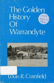
Book, The Golden History of Warrandyte - Louis R. Cranfield
History of more than a 100 years from the earliest days of the discovery of gold and the setting up of a mining camp through to the transition of becoming a thriving township -
 Bendigo Historical Society Inc.
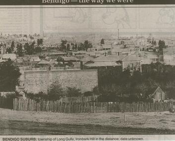
Newspaper - JENNY FOLEY COLLECTION: BENDIGO SUBURB
Bendigo Advertiser ''The way we were'' from 2000. Bendigo suburb: township of Long Gully, Ironbark Hill in the distance; date unknown. The clip is in a folder.newspaper, bendigo advertiser, the way we were -
Clunes Museum
Map, FENTON CHARLES, 1987
TRANSPARENT PLASTIC SHEET WITH A MAP OF CLUNES TOWNSHIP DRAWN IN BLACK WITH TINY WHITE STICKERS DENOTING POINTS OF INTEREST, MOUNTED TO BROWN PAPER AND PINNED IN PLACE ON REVERSE OF BROWN PAPER WRITTEN IN BLACK IN "CLUNES 1987 TRACINGS"clunes 1987, clunes township map -
Tatura Irrigation & Wartime Camps Museum
Book, Warwick Finlay, The Doctor, The Captain, The Poet and Others, 2004
This book was printed to commemorate the 150th Anniversary of the survey, naming of the town and sale of land at Murchison.Black and white cover featuring the Goulburn River and portraits of Doctor McMillan, Captain John Murchison and Orion Horne over and early plan of Murchison Townshipmurchison -
Lakes Entrance Regional Historical Society (operating as Lakes Entrance History Centre & Museum)
Postcard, 1915 c
Black and white postcard showing SS Gippsland in Cunninghame Arm opposite New Works houses and works buildings with township in background Lakes Entrance Victoriaships and shipping, jetties -
 Clunes Museum
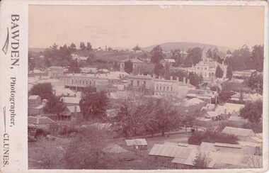
Photograph, BAWDEN - PHOTOGRAPHER, CLUNES, VICTORIA
SEPIA POSTCARD / PHOTOGRAPH - OVERVIEW OF CLUNES TOWNSHIP. S.S. BANK. CLUB HOTEL, POST OFFICE, TOWNHALL, WESLEY CHURCH AND TWO MILE HILL IN BACKGROUND.TO WISH YOU ALL GOOD CHRISTMAS BLESSINGS AND A HAPPY NEW YEAR. J. PATIENCE DEC. 1907.local history, photography, photographs, clunes township -
 Lakes Entrance Regional Historical Society (operating as Lakes Entrance History Centre & Museum)
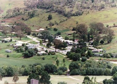
Photograph, Tambo Shire, 1994 c
Also second identical copyColour photograph of the township of Buchan, taken from a high point above the town which is situated in a valley with hills rising on all sides. Buchan Victoriawaterways, topography -
Lakes Entrance Regional Historical Society (operating as Lakes Entrance History Centre & Museum)
Postcard, H D Bulmer, 1922
Black and white postcard of western end of township showing front lake and buildings on Esplanade with boat on slipway left side of image, Lakes Entrance VictoriaLakes Entranceguesthouses, tourism -
Clunes Museum
Document - HISTORY TALBOT TOWNSHIP, 1970
.1 HISTORY OF TALBOT TOWNSHIP 1852 .2 PORTION OF LIST OF CLUNES BUILDINGS, CHURCHES, HOSPITAL, RAILWAY STATION ETC. COMPILED BY CONRAD WEICKHARDT 1970local history, document, talbot, history, history of talbot & clunes -
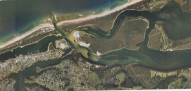 Lakes Entrance Regional Historical Society (operating as Lakes Entrance History Centre & Museum)
Photograph - Lakes Entrance, Gippsland Ports, 2006 c
Colour aerial photograph showing view of entrance to Gippsland Lakes from Bass Strait Reeves Channel Rigby Island and township of Lakes Entrance Victoriaaerial photograph, historic site, dredging, waterways, lakes entrance