Showing 1122 items
matching waterway
-
 Lakes Entrance Historical Society
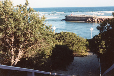
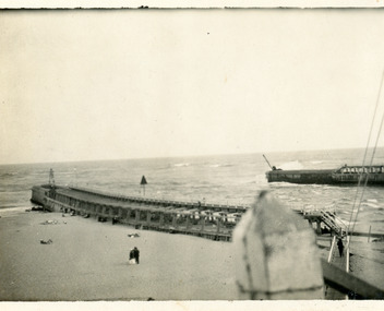
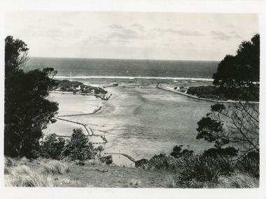
Photograph - Western Pier, Holding M, 1997
Date made July 1997Colour photograph of the western pier of the entrance to the Gippsland Lakes from Bass Strait, showing surf breaking on offshore bar, signal triangles, walking path and vegetation in foreground. Lakes Entrance VictoriaEntrance (on back) waterways, piers -
 Lakes Entrance Historical Society
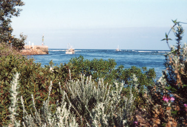
Photograph - Western Pier, Holding M, 1997
Date made July 1997Colour photograph of the western pier of the entrance to the Gippsland Lakes, Lakes Entrance Victoria waterways, piers -
 Lakes Entrance Historical Society
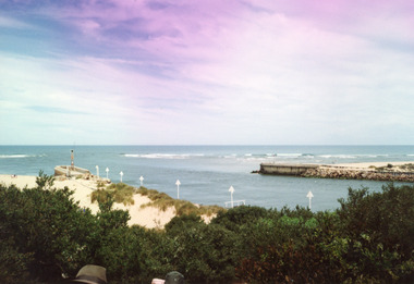
Photograph - Western Pier, Holding M, 1997
Date made July 1997Colour photograph of the western pier of the entrance to the Gippsland Lakes, Lakes Entrance Victoria waterways, piers -
 Lakes Entrance Historical Society
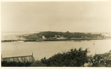
Photograph - The Entrance, 1910c
also copies|Two black and white 8.5 x 14|Two black and white 16 x 25Sepia photograph showing view of entrance to Gippsland Lakes from ocean- Bass Strait, looking west towards Western Pier and dunes. Foreground on left shows gable roof of rocket shed and shipwreck bell on white post on right. Lakes Entrance Victoriawaterways, sandbar, rocket shed -
 Lakes Entrance Historical Society
Photograph - The Entrance, 1919
Black and white photograph showing entrance to Gippsland Lakes from ocean - Bass Strait. Beach on left side of Eastern Pier. Lakes Entrance Victoriapiers, waterways -
 Lakes Entrance Historical Society
Photograph - The Entrance, 1922
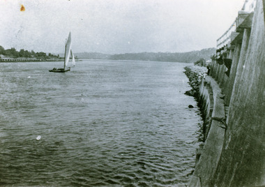
Black and white photograph showing entrance and piers, viewed from ocean end of pier looking north towards Kalimna, small sailing boat in entrance inside of Eastern Pier, on right amongst the timber piers is a man leaning out. Lakes Entrance Victoria waterways, piers, boats and boating -
 Lakes Entrance Historical Society
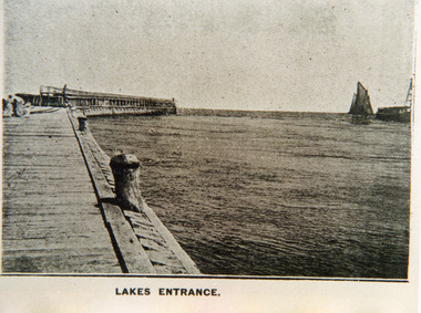
Photograph - Eastern Pier, 1900c
Black and white photograph showing early Eastern Pier at entrance to Gippsland Lakes from ocean, tip of Western Pier showing next to sailing boat, two ladies and one child far left on Eastern Pier, two bollards on eastern pier. Lakes Entrance VictoriaLakes Entrance waterways, piers -
 Lakes Entrance Historical Society
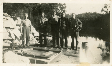
Photograph - Tramline, 1930c
Four men named are Harbeck, George Fraser, Ted Dinelli and Fitzclarence.Black and white photograph of five workmen standing on the barge at the landing at the head of North Arm. It shows a pile of rock on the shore, a large bit of rock in the barge. Lakes Entrance Victoriaquarries, waterways, transport, public works, room display -
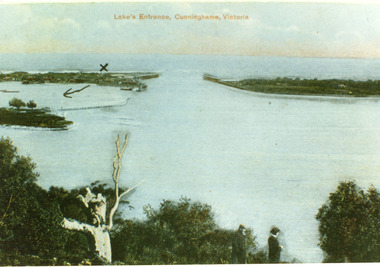
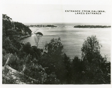
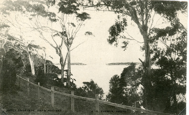 Lakes Entrance Historical Society
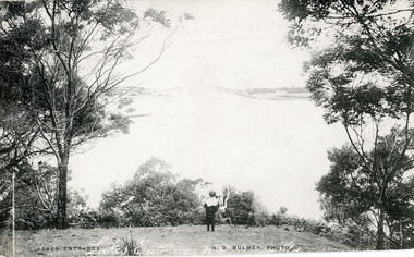
Postcard - The Entrance, Bulmer H D, 1910c
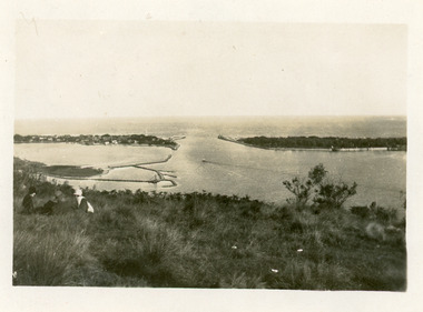
Black and white postcard of the man made entrance through the hummocks, taken from the cliff top at Kalimna. Shows an indistinct distant view of the entrance, natural vegetation in foreground behind simple timber and chicken wire boundary fence. Lakes Entrance VictoriaLakes Entrance from Kalimnawaterways, topography, islands -
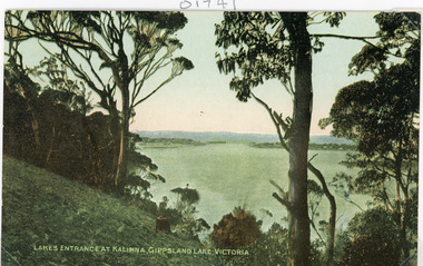 Lakes Entrance Historical Society
Postcard - The Entrance, 1910c
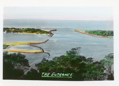
Colour tinted postcard of the man made entrance to the Gippsland Lakes. It shows the entrance and groynes at Bullock Island, natural vegetation on cliff top in foreground. Lakes Entrance VictoriaLakes Entrance at Kalimna, Gippsland Lakes Victoriavegetation, waterways, topography -
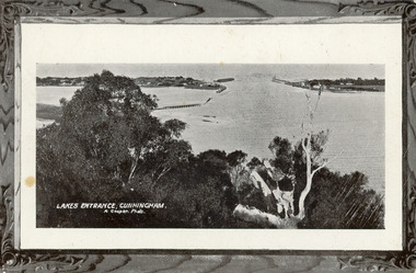
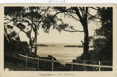 Lakes Entrance Historical Society
Postcard - The Entrance
Black and white postcard of the man made entrance through the sand hummocks, taken from Kalimna cliff top. In the foreground native vegetation on the cliff top behind simple timber and wire netting boundary fence topped with a single strand of barbed wire. Lakes Entrance VictoriaThe Entrance from Kalimnawaterways, topography, islands -
 Lakes Entrance Historical Society
Postcard - The Entrance, 1940c
2 x identical mini postcards collected 6.5 x 9|1 x photographic print copy 18.5 x 25Black and white small format postcard of the man-made entrance from Bass Strait to the Gippsland Lakes, taken from Jemmys Point. It shows the rock groynes at Bullock Island and North Arm entrance. Lakes Entrance Victoriaislands, waterways, topography -
 Lakes Entrance Historical Society
Postcard - The Entrance, Bulmer H D, 1940c
Hand tinted small format postcard of the entrance to the Gippsland Lakes, taken from Jemmys Point. It shows the rock groynes at Bullock Island with dredged sand filling the basin between island and groyne. Lakes Entrance VictoriaThe Entranceislands, waterways, topography -
 Lakes Entrance Historical Society
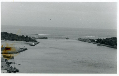
Photograph - The Entrance, 1986
Black and white photograph of the entrance from Bass Strait to the Gippsland Lakes. It also shows the rock groynes at Bullock Island filled with dredged sand to extend the island. Fishing boat coming through entrance. Lakes Entrance Victoriaislands, topography, waterways -
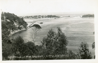
 Lakes Entrance Historical Society
Photograph - The Entrance, 1950c
Black and white photograph of the man-made entrance from Bass Strait to the Gippsland Lakes, taken from the lookout tower on Jemmys Point. In foreground is the natural vegetation of Jemmys Point and a glimpse of the light beacon. Lakes Entrance Victoriaislands, waterways -
 Lakes Entrance Historical Society
Postcard - The Entrance, 1940c
Black and white small format postcard of the man-made entrance to the Gippsland Lakes taken from Jemmys Point. It also shows the rock groynes at Bullock Island and entrance to Cunninghame Arm. Lakes Entrance Victoriawaterways, topography -
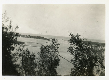
 Lakes Entrance Historical Society
Photograph - The Entrance, 1939c
Black and white photograph of Bullock Island, rock groynes, lake and man-made entrance taken from Jemmys Point. Three people sitting on grass in left foreground. Lakes Entrance Victoriawaterways, topography -
 Lakes Entrance Historical Society
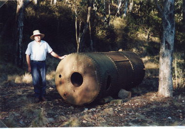
Photograph - Tramline, Fish Marie, 1977
Date made 18 January 1977.Colour photograph of Rex Fish standing beside the boiler which provided steam power to drive the winch to transfer rock from the tram, trucks to the barge at North Arm. This rock quarried at Mississippi Creek was used to stabilise the entrance piers, and build rock groynes around the lakes. Lakes Entrance Victoria waterways, historic sites, public works, machinery -
 Lakes Entrance Historical Society
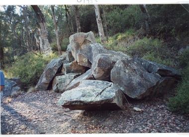
Photograph - Tramline, Fish Marie, 1997
Date made 18 January 1997Colour photograph of a pile of granite rock left on the bank of the North Arm. This rock was quarried at Mississippi Creek and conveyed by tramline to the North Arm where it was loaded on barges and conveyed to the entrance where it was used to stabilise the piers. Lakes Entrance Victoria waterways, public works, quarries -
 Lakes Entrance Historical Society
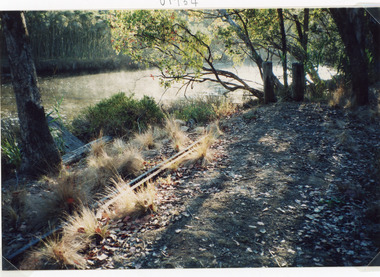
Photograph - Tramline, Fish Marie, 1997
Date made 18 January 1997Colour photograph of a remnant of the tramway which ran from the Mississippi Creek quarry to the head of the North Arm. It shows two lengths of discarded iron rail on the bank of the creek. Lakes Entrance Victoriawaterways, public works, transport, historic site -
 Lakes Entrance Historical Society
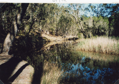
Photograph - Mississippi Creek Landing, Fish Marie, 1997
Date made 18 January 1997Color photograph of Mississippi Creek at the head of the North Arm. It shows natural vegetation on the banks of the creek, which is reflected in the calm waters. Lakes Entrance Victoria waterways, transport -
 Lakes Entrance Historical Society
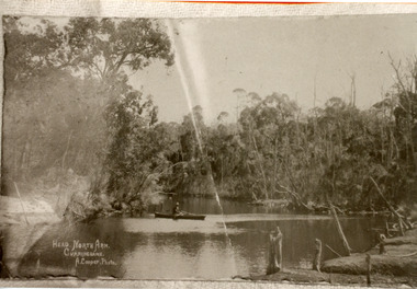
Photograph - North Arm, Cooper Alexander, 1910c
Copied from original by Merle DerbyshireBlack and white photograph of a section of the North Arm. It shows a person in a small boat on the calm waters, dense natural vegetation on each side of lake. Lakes Entrance VictoriaHead, North Arm, Cunninghame waterways, topography, recreation -
 Lakes Entrance Historical Society
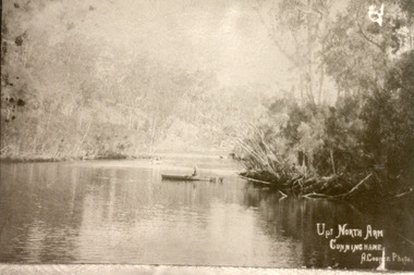
Photograph - North Arm, Cooper Alexander, 1910c
Copied from original by Merle DerbyshireBlack and white photograph of a calm reach of the North Arm. It shows dense vegetation on both sides of the water, person sitting in small boat on lake. Lakes Entrance VictoriaUp North Arm, Cunninghame waterways, topography, recreation -
 Lakes Entrance Historical Society
Postcard - The Entrance, Bulmer H D, 1910c
Also black and white enlargement size 16 x 25.| Note on back of postcard, 'Bemm River 16/8/11, To My Dear Elsie, Just a line....., Much love from all, Annie.'Black and white postcard of the man made entrance through the sand hummocks, taken from Jemmys Point. Small boy looking towards entrance, natural vegetation on brow of hill. Lakes Entrance VictoriaLakes Entrance waterways, topography -
 Lakes Entrance Historical Society
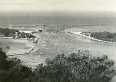
Postcard - The Entrance, 1900c
Also copy tinted postcard 10 x 15Coloured post card of the man made entrance through the sand dunes, taken from Jemmys Point. It shows the works and settlement at the entrance, Bullock Island and groynes to direct flow of lake waters towards entrance. Two men standing on Jemmys Point. Lakes Entrance VictoriaLakes Entrance, Cunninghame, Victoriaislands, waterways, topography -
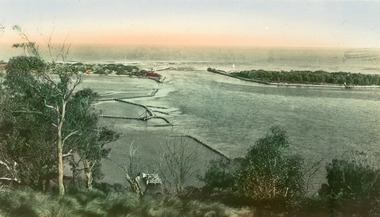
 Lakes Entrance Historical Society
Postcard - The Entrance, The Lakes Studio, 1940c
1 other tinted Postcard in Spares BoxBlack and white postcard of the man-made entrance to the Gippsland Lakes, taken from Kalimna cliff top. It shows the jetty and residences at the New Works, rock groynes, barge in lake, steep cliff of Jemmys Point and natural vegetation of Kalimna in foreground. Lakes Entrance VictoriaEntrance from Kalimna, Lakes Entranceislands, waterways, topography -
 Lakes Entrance Historical Society
Postcard - The Entrance, 1905c
Message on back of card, to 'Misses M & A Henderson, Swan Reach, Just a line to wish ......, Yours sincerely, R J Gilsenan.'Black and white postcard of the man made entrance. It shows the works building and cottages on each side of the entrance, timber cribs and rock groynes at Bullock Island, natural vegetation of Jemmys Point in foreground. Lakes Entrance VictoriaLakes Entrance, Cunningham topography, waterways, correspondence -
 Lakes Entrance Historical Society
Postcard - The Entrance, 1935c
Also small format identical postcard 6.5 x 8.5, very faded,|also small format photo, same view donated by D & M FletcherBlack and white small format postcard of the man made entrance to the Gippsland Lakes, taken from Jemmys Point. It shows the rock groynes beside Bullock Island, a barge in North Arm below Jemmys Point. Lakes Entrance VictoriaThe Entrance to Gippsland Lakes waterways, topography -
 Lakes Entrance Historical Society
Postcard - The Entrance, 1935c
Also 2 identical small format postcardsBlack and white small format postcard taken from the cliff top at Kalimna. It shows the man made entrance through the hummocks, rock groynes, Jemmys Point cliff and natural vegetation in foreground. Lakes Entrance VictoriaEntrance from Kalimna, Lakes Entrance waterways, topography -
 Lakes Entrance Historical Society
Postcard - The Entrance, Valentine Series, 1935c
Hand tinted postcard of the man-made entrance to the Gippsland Lakes, taken from Jemmys Point. It shows the rock groynes at Bullock Island and Entrance to North Arm, a barge in North Arm directly below Jemmys Point. Lakes Entrance Victoriaislands, waterways, topography