Showing 1145 items
matching waterways
-
 Lakes Entrance Regional Historical Society (operating as Lakes Entrance History Centre & Museum)
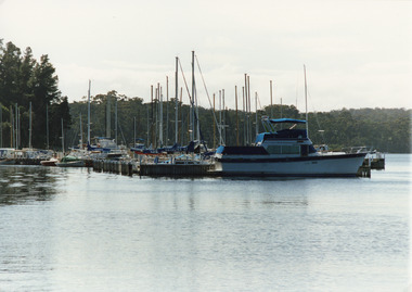
Photograph, Tambo Shire, 1994
... Waterways ...Also second identical copyColour photograph of Metung Marina on Bancroft Bay, showing yachts and cruisers moored at the jetties. Metung Victoriahouses, waterways, boats and boating -
 Lakes Entrance Regional Historical Society (operating as Lakes Entrance History Centre & Museum)
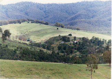
Photograph, Tambo Shire, 1994
... Waterways ...Also second similar copyColour photograph taken at The Basin, showing hilly farmland, dense forest on ranges in distance. Buchan Victoriatopography, waterways, vegetation -
 Lakes Entrance Regional Historical Society (operating as Lakes Entrance History Centre & Museum)
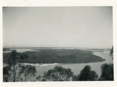
Photograph, 1930c
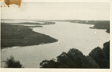
... Waterways ...Second copy similar viewBlack and white photograph of Rigby Island, Gippsland Lakes Victoria. It shows Reeves Channel on right of photo, Hopetoun Channel on left, The Narrows below Jemmys Point from which photo was taken. Lakes Entrance Victoriaislands, waterways, topography -
 Lakes Entrance Regional Historical Society (operating as Lakes Entrance History Centre & Museum)
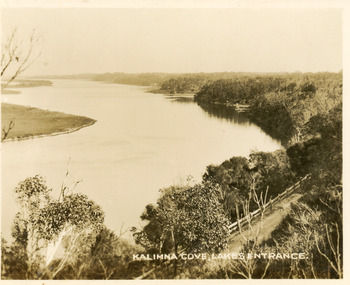
Postcard, Valentine Series, 1930c
... Waterways ...Black and white small format postcard of Reeves Channel Gippsland Lakes, taken from Jemmys Point. It shows a glimpse of the Princes Highway, the steep shoreline of the mainland opposite Rigby Island with Fraser Island and Flannagan Island in distance. Lakes Entrance VictoriaKalimna Cove Lakes Entranceislands, waterways, topography -
 Lakes Entrance Regional Historical Society (operating as Lakes Entrance History Centre & Museum)
Postcard, 1930c
... Waterways ...Black and white small format postcard of a steamer in the Narrows, Rigby Island opposite the steep shoreline of the mainland, Reeve's Channel, Fraser Island and Flannagan Island in distance, Gippsland Lakes, Lakes Entrance Victoria.islands, waterways, topography -
 Lakes Entrance Regional Historical Society (operating as Lakes Entrance History Centre & Museum)
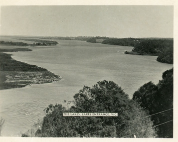
Postcard, Valentine Series, 1930c
... Waterways ...Other copy similar view with inscription 'The Lakes, Lakes Entrance Vic'Black and white postcard of Reeves Channel Gippsland Lakes, showing Rigby, Fraser and Flannagan Islands opposite the steep shoreline of the mainland. Natural vegetation of Jemmys Point in foreground from which photograph was taken. Lakes Entrance VictoriaKalimna from Jemmys Point Lakes Entranceislands, waterways, topography -
 Lakes Entrance Regional Historical Society (operating as Lakes Entrance History Centre & Museum)
Photograph, 1930c
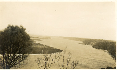
... Waterways ...Black and white photograph of Reeves Channel on Lake King, Gippsland Lakes. It shows part of Rigby Island opposite the steep mainland shore of the lake. Lakes Entrance Victoriaislands, waterways, topography -
 Lakes Entrance Regional Historical Society (operating as Lakes Entrance History Centre & Museum)
Photograph, 1950c
... Waterways ...Also copy of same view, stained, 9 x 14Black and white photograph of the Narrows and Reeves Channel of Lake King, Gippsland Lakes. It shows Rigby, Fraser, and Flannagan Islands opposite the steep shoreline of the mainland. Taken from Jemmy's Point, it shows a recently built groyne from Rigby Island into the Narrows. Lakes Entrance Victoriaislands, waterways, topography -
 Lakes Entrance Regional Historical Society (operating as Lakes Entrance History Centre & Museum)
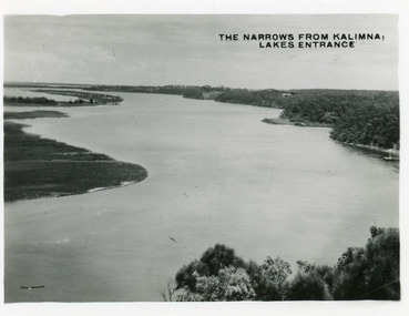
Postcard, Bulmer H D, 1945c
... Waterways ...Also two other copies 6.5 x 8.5Black and white small format postcard of the Narrows, and Reeves Channel of Lake King, Gippsland Lakes, showing Rigby, Fraser and Flannagan Islands opposite the steep shoreline of the mainland. Taken from Jemmys Point. Lakes Entrance VictoriaThe Narrows from Kalimna Lakes Entranceislands, waterways, fishing industry -
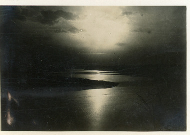 Lakes Entrance Regional Historical Society (operating as Lakes Entrance History Centre & Museum)
Postcard, Bulmer H D, 1930c
... Waterways ...Second copy 5.5 x 8.5Black and white large format postcard showing moonlight reflections through clouds and across Reeves Channel of Lake King, Gippsland Lakes. Dark form of Rigby Island breaks the reflection on the lake. Lakes Entrance VictoriaMoonlight from Jemmys Point Lakes Entranceislands, boats and boating, waterways -
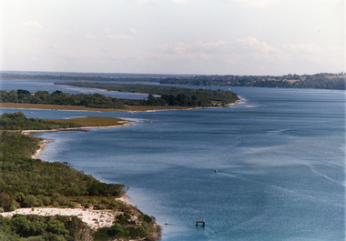 Lakes Entrance Regional Historical Society (operating as Lakes Entrance History Centre & Museum)
Photograph, Tambo Shire, 1995c
... Waterways ...Also second copyColour photograph of portion of Rigby Island, Fraser Island, and Flannagan Island, and Reeves Channel of Lake King, Gippsland Lakes. Steep shore of mainland in distance. Lakes Entrance Victoriaislands, waterways, topography -
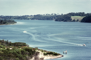 Lakes Entrance Regional Historical Society (operating as Lakes Entrance History Centre & Museum)
Photograph, Fraser, Ian, 1995c
... Waterways ...Colour photograph of Reeves Channel of Lake King, Gippsland Lakes. It shows part of both Rigby Island and Fraser Island opposite the steep shoreline of the mainland. Two motor boats on lake. Lakes Entrance Victoriaislands, waterways, topography -
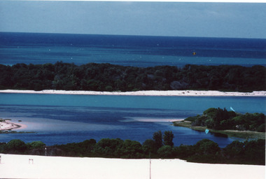 Lakes Entrance Regional Historical Society (operating as Lakes Entrance History Centre & Museum)
Photograph, Fraser, Ian, 1996c
... Waterways ...Colour photograph of Bass Strait, scrub covered coastal dunes, Hopetoun Channel, and southern portion of Rigby Island. Photo taken from sand dunes on Flannagan Island, near Lakes Entrance, Victoria.islands, waterways, topography -
 Lakes Entrance Regional Historical Society (operating as Lakes Entrance History Centre & Museum)
Photograph, Bulmer H D, 1940c
... Waterways ...Black and white photograph of view over Kalimna, Maringa Creek, Saw Mill Flat, Fraser Island, Flannagan Island, aireal view. Lakes Entrance, Victoria.waterways, topography, tourism -
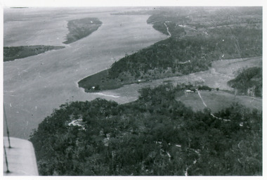
 Lakes Entrance Regional Historical Society (operating as Lakes Entrance History Centre & Museum)
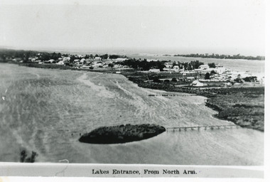
Photograph, Bulmer H D, 1940c
... Waterways ...Black and white photograph of aerial view of township. It shows route of Princes Highway through town, turning north at Myer Street and continuing along Roadknight Street. Few jetties on North Arm, many on Cunninghame Arm. In far upper left of image sea is breaking on sand hummocks. Lakes Entrance Victoriawaterways, vegetation, boats and boating -
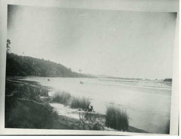 Lakes Entrance Regional Historical Society (operating as Lakes Entrance History Centre & Museum)
Photograph, Phillips, Miss L, 1910c
... Waterways ...Black and white photograph of North Arm. It shows the reedy shoreline in foreground, jetty to island in lake, two small boats on water, distant view of township. Lakes Entrance Victoriawaterways, topography, vegetation -
 Lakes Entrance Regional Historical Society (operating as Lakes Entrance History Centre & Museum)
Photograph, 1926c
... Waterways ...Black and white photograph showing upper reaches of North Arm. Small rowing boat with several people standing in boat. Reflection of vegetation on water. Lakes Entrance Victoriatopography, township, waterways -
 Lakes Entrance Regional Historical Society (operating as Lakes Entrance History Centre & Museum)
Photograph, 1924
... Waterways ...Black and white small format photograph showing upper reaches of North Arm. Reflections of vegetation on water. Lakes Entrance Victoriatopography, waterways, boats and boating -
 Lakes Entrance Regional Historical Society (operating as Lakes Entrance History Centre & Museum)
Photograph, 1915c
... Waterways ...Other copy 12.5 x 17.5Black and white photograph of the North Arm, showing a mud island in the arm behind the township, Cunninghame Arm, sand hummocks of the southern shore and Bass Strait in distance. Lakes Entrance VictoriaLakes Entrance from North Armvegetation, topography, waterways -
 Lakes Entrance Regional Historical Society (operating as Lakes Entrance History Centre & Museum)
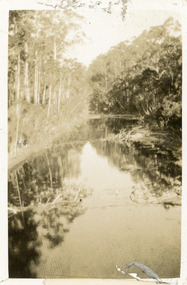
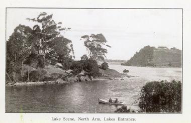
Photograph, 1920c
... Waterways ...Copy same view but titled 'North Arm - Lakes Entrance' 11.5 x 18Black and white photograph of the North Arm. It shows the calm waters of the arm which twist and turn between high scrub covered banks. Distant view of township, two people in small boat in foreground. Lakes Entrance VictoriaLakes Scene North Arm Lakes Entrancevegetation, topography, waterways -
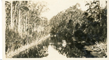
 Lakes Entrance Regional Historical Society (operating as Lakes Entrance History Centre & Museum)
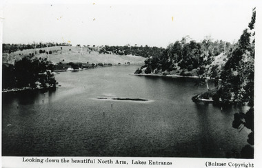
Photograph, Bulmer H D, 1930c
... Waterways ...Black and white photograph of the North Arm, showing the calm waters between steep banks covered in natural vegetation, but for one hillside which has been almost completely cleared, a few ring barked trees still standing. Lakes Entrance VictoriaLooking down the beautiful North Arm Lakes Entrancevegetation, waterways, topography -
 Lakes Entrance Regional Historical Society (operating as Lakes Entrance History Centre & Museum)
Postcard, 1930c
... Waterways ...Black and white postcard of the calm waters of North Arm. It shows the lake below steep tree covered banks. Lakes Entrance VictoriaNorth Arm Lakes Entrancewaterways, vegetation, boats and boating -
 Lakes Entrance Regional Historical Society (operating as Lakes Entrance History Centre & Museum)
Photograph, 1950c
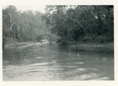
... Waterways ...Black and white photograph of a tourist launch travelling upstream between high tree covered banks on the North Arm, Lakes Entrance, Victoria.township, waterways, topography -
 Lakes Entrance Regional Historical Society (operating as Lakes Entrance History Centre & Museum)
Photograph, 1940c
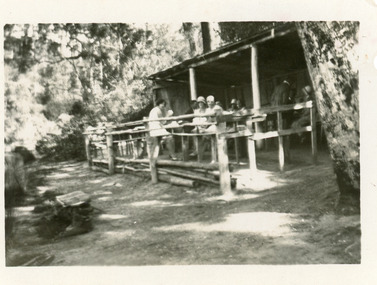
... Waterways ...Also an enlarged copy in brown tones 10 x 15.5Black and white photograph of Mrs Comer's rustic Tea Rooms on the North Arm. It shows a rough bush construction, outside seating and tables, surrounded by bushland. Group of tourists seated at tables. Lakes Entrance Victoriaanimals, waterways, township -
 Lakes Entrance Regional Historical Society (operating as Lakes Entrance History Centre & Museum)
Postcard, 1945c
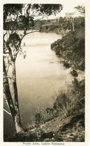
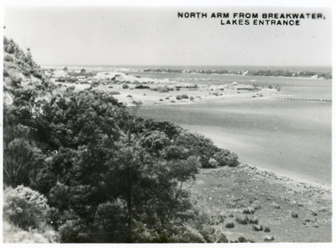
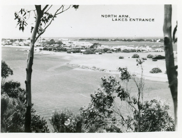
... Waterways ...One other copy same sizeBlack and white small format postcard of the entry to the North Arm, taken from Jemmys Point. It shows a steep cliffside above the calm waters, township of Lakes Entrance and Cunninghame Arm, and sand hummocks of southern shore in distance. Lakes Entrance VictoriaNorth Arm from Breakwater - Lakes Entrancetownship, waterways, topography -
 Lakes Entrance Regional Historical Society (operating as Lakes Entrance History Centre & Museum)
Postcard, 1945c
... Waterways ...Photo taken soon after extensive dredging operations when tons of sand were dumped on low lying land at western end of town.Black and white small format postcard of the North Arm. It shows the township between North Arm and Cunninghame Arm. Lakes Entrance VictoriaNorth Arm Lakes Entrancewaterways, topography, fences -
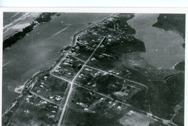
 Lakes Entrance Regional Historical Society (operating as Lakes Entrance History Centre & Museum)
Postcard, Engelander John & Co Pty Ltd, 1980c
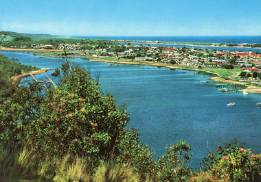
... Waterways ...Panoramic view of Lakes Entrance taken by Melbourne firm for West Germany A.F.K. International Publishers of world's most famous beauty spotsColour postcard with serrated edge, of the township, situated between Cunninghame Arm and North Arm. Boats moored at jetties and beside boat ramps in North Arm. Photo taken from Kalimna Heights. Dredged sand dumped in North Arm bight. Lakes Entrance VictoriaLakes Entrance, Victoria, Australia (on back)boats and boating, waterways, topography -
 Lakes Entrance Regional Historical Society (operating as Lakes Entrance History Centre & Museum)
Photograph, Fraser, Ian, 1985c
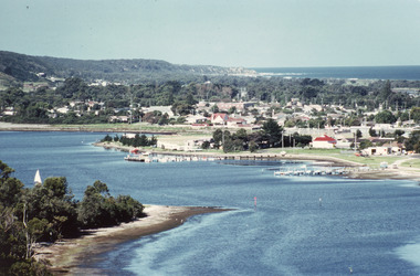
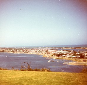
... Waterways ...Colour photograph of the township, situated between Cunninghame Arm and North Arm. Boats moored in North Arm. Scrub covered hummocks of southern shore in background, taken from cleared vantage point on Kalimna Heights. Lakes Entrance Victoriaretail trade, boats and boating, waterways -
 Lakes Entrance Regional Historical Society (operating as Lakes Entrance History Centre & Museum)
Photograph, Fraser, Nancy, 1985c
... Waterways ...Colour photograph of a bend in the North Arm. It shows the sports ground, eastern end of town. Jetties and hire boats at edge of lake. Photo taken from cleared hill, Kalimna, in foreground. Bass Strait in distance. Lakes Entrance Victoriawaterways, houses, vegetation -
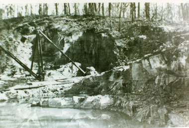 Lakes Entrance Regional Historical Society (operating as Lakes Entrance History Centre & Museum)
Photograph, 1930c
... Waterways ...Black and white photograph of the granite quarry in the Colquhoun forest to the north. The stone was used to reconstruct the piers at the entrance from 1910 to 1930. Lakes Entrance Victoriaboats and boating, waterways, public works