Showing 7550 items
matching kew
-
 Melbourne Tram Museum
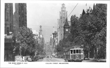
Postcard, Rose Stereograph Co, "Collins Street Melbourne", late 1930s
Rose Series postcard No. P 1523, titled "Collins Street Melbourne", with W2 class tram 388 (Kew Depot, route 47), climbing the hill to Russell Street. Yields information about Collins Street mid 1930s.Postcard - printed real photograph with Rose Stereograph Co. name on the rear.tramways, trams, w2 class, collins st, tram 388, route 47 -
 Kew Historical Society Inc
Certificate - Certificate of Completion, Department of Mental Hygeine (Victoria), Certificate of Qualification, Mental Attendant, Department of Mental Hygiene (Victoria), 1945
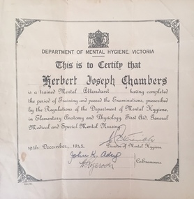
Herbert Joseph Chambers was born in 1912 in Clifton Hill, Victoria. Later he was to live in Clark and Charles Streets in Northcote, in South Caulfield, and finally in Mentone. While he may have worked at the Kew Asylum before 1945, that year was when he was presented with a Certificate issued by the Department of Mental Hygiene (Victoria) declaring that he had completed training and passed the examinations required to work as a 'Mental Attendant’. The document is dated 19th December 1945 and signed by the Director of the Department and by the Co-Examiners. From at least 1945, he was to work as a member of the male staff of the Asylum, mainly in the Refractory Ward. A donor gifted to the Kew Historical Society in February 2019 a number of items collected by Herbert Chambers in his work at the Asylum. These include his Certificate of Registration, a photograph taken of him with two colleagues at Circular Quay in Sydney, a notebook containing ‘SP’ betting records of male asylum staff, and five sketchbooks with artwork created by Kenn’th [sic] Bailey, a patient of the Asylum. Herbert Chambers’ period of employment at the Kew Asylum coincided with the employment of the English psychiatrist Dr Eric Cunningham Dax (1908-2008) as Chairman of the Mental Hygiene Authority in 1952. Dr Dax introduced an art therapy program into Victorian psychiatric hospitals, including Kew, where it is likely that the five sketchbooks were created. The sketchbooks are believed to have been presented to Chambers by Bailey as a “gift for looking after him”. Herbert Chambers retired from the Kew Asylum in c.1970 after working there for almost thirty years.Representative example of certification required to work as a Mental Attendant in Victoria.Certificate issued by the Department of Mental Hygiene (Victoria) declaring that Herbert Joseph Chambers has completed training and passed examinations required to work as a 'Mental Attendant. The document, dated 19th December 1945 is signed by the Director of the Department and by the Co-Examiners.Department of Mental Hygiene Victoria This is to certify that HERBERT JOSEPH CHAMBERS is a trained MEDICAL ATTENDANT having completed the period of Training and passed the Examinations, prescribed by the Regulations of The Department of Mental Hygiene, in Elementary Anatomy and Physiology, First Aid, General Medical and Special Mental Hygiene. 19TH DECEMBER, 1945 Signed by the Director of Mental Hygiene and two Co-Examinersherbert joseph chambers, kew mental hospital, department of mental hygeine - victoria -
 Glen Eira Historical Society
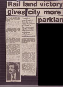
Article - Mayor Jack Campbell 1987-88 (1 of 2)
Newspaper articles and 3 colour photographs relating to Outer Circle Rail Landcouncillor, mayor, jack campbell, brian rudski, malvern, kew, caulfield, premier john cain, mrs cain -
 Mission to Seafarers Victoria
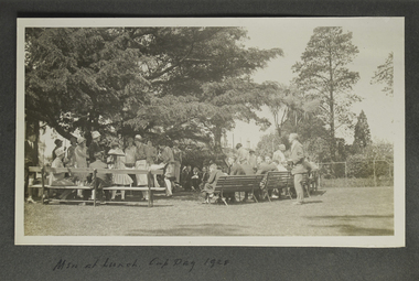
Photograph - Photograph, Sepia, Men at Lunch, Cup Day 1928 (6 Nov. 1928), 6 November 1928
on page 12.finhaven, kew, mr john inerrarity buchan, picnics, social events, fan album, cup day, 1928, reverend john reginald weller (1880-1969) -
 Ruyton Girls' School
Headwear - Ruyton Girls' School Beret, c.1980s
Worn by a Ruyton Girls' School student 1984-1990 as part of winter school uniform.Navy blue wool felt beret. Features additional square cloth panel hand sewn onto centre front. Panel shows embroidered Ruyton Girls' School crest of an 'Old English' alphabet character 'R' in gold thread on navy blue background. Interior of beret is plain.'R'ruyton girls' school, kew, school uniform, hat, 1980s, 1990s, school crest, embroidery, private school -
 Kew Historical Society Inc
Album - Victorian Canoe Club : Album 2, 1931-5
Canoeing on the River Yarra at Melbourne was an important and widespread recreational pursuit for Melbournians, especially in the first half of the twentieth century. The Victorian Canoe Club was formed in 1912 at a meeting in Melbourne and its first committee elected in the same year. Records indicate that the Club continued into at least the 1950s .The album has historic and social significance as a record of recreational activities in the early years of the twentieth century.Part of an unbound old album, containing photographs of members of the Victorian Canoe Club undertaking a series of trips to the lower and upper Yarra as well as to regional Victoria. All but one of the photographs in the album were labelled by the owner in white ink. The individual photographs in this album are also posted on Victorian Collections separately, typically under the label of the photo in the album. E.g "Salvaging wrecked canoe". Descriptive titles in the album include (sometimes referring to two photos): Xmas 1930, Leaving Studley Park / Breakfast on wharf after camping on lower Yarra / repacking / Old Cerberus / Shooting the rapids, Warrandyte / [Untitled] / Pound Bend tunnel (2) / Old mine / Salvaging wrecked canoe / Mallacoota trip / Gippsland LakesNil apart from individual photo labelsvictorian canoe club, river yarra, kew, warrandyte, upper yarra, lower yarra, cerberus, mallacoota, recreation -- canoeing -
Canterbury History Group
Document - List of significant trees, May 2001 - May 2003
Lists of significant trees on public land and private property in Boroondaracanterbury, camberwell, deepdene, balwyn, kew, hawthorn, glen iris, surrey hills, trees -
 Kew Historical Society Inc
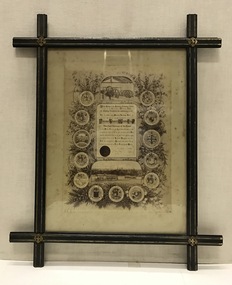
Certificate, Melbourne Tramways Trust, Framed Testimonial to Alderman Thomas O'Grady J.P. from the Melbourne Tramways Trust, 5 February 1886
The recipient of the testimonial, Thomas O’Grady (1824-90) had migrated to Melbourne in 1854, practising the trades of building and contracting. The Australian Dictionary of Biography records that he became a Councillor of the City of Melbourne in 1868. It lists one of his major achievements as the construction ‘with Leggett & Noonan [of] the fifty-six-mile (90 km) railway from Essendon to Seymour’. He was chairman of the Tramways Trust from its formation in 1884. His obituary in the Melbourne Herald (29 Apr 1890) reported: "DEATH OF ALDERMAN THOMAS O'GRADY. Today we have the sad duty of recording the death of two old colonists, who for many years, havo occupied very, prominent positions in building, commercial and municipal circles. The first of these is Alderman Thomas O'Grady, who died last night at his residence in Carlton. Mr O'Grady has been ill for some time, and at one period his death was expected any moment. Then he rallied, and strong hopes of his recovery were entertained; but he had a relapse, and expired as stated. The deceased gentleman was one of the oldest members of the City Council, in which he has held the various positions of Councillor, Alderman and Mayor. At the time of his death he sat as alderman for Victoria Ward. Mr O'Grady also at one time represented the City Council on the Harbor Trust, and was chairman of that body. He has been the council's representative on the Tramway Trust and was chairman of that body for some considerable time." As late as 1951, the Advocate (11 Oct 1951) stated that: "To Alderman Thomas O'Grady, Lord Mayor of Melbourne in 1872-3, is due the credit of the successful inauguration of Hospital Sunday. Alderman O'Grady was the first Catholic Lord Mayor of the city. He was elected a councillor for Smith Ward in 1868, and an alderman in 1869. In private life he was an extensive contractor, being a member of the firm of O'Grady, Leggett and Noonan, the contractors for the first section of the Northeastern Railways (between Melbourne and Seymour)."This is a unique civic document, illustrating the life and contribution of Thomas O’Grady (1824-90), Melbourne City Councillor and first Chairman of the Melbourne Tramways Trust. It is historically significant in its recording of the development of Melbourne's public transport system. The design of the certificate and particularly the ebonised frame are artistically and aesthetically significant.An illustrated testimonial presented to the first Chairman of the Melbourne Tramways Trust in 1886. The Testimonial is encased in an ebonized frame of the period. It includes the coat-of-arms of 12 cities, corporations, boroughs and towns, including that of Kew. At the head of the testimonial the engines used to drive the cable systems are illustrated. At the foot of the testimonial there is a picture of two cable trams.The testimonial reads: ‘At the meeting of the Melbourne Tramways Trust held on the Fifth Day of February 1886, the following resolution was unanimously carried. That the thanks of the Melbourne Tramways Trust are due and are hereby accorded to Alderman Thomas O’Grady Hon. JP, the first Chairman of the Trust for the ability, courtesy and impartiality with which he has discharged his duties during the past two years, and the Trust heartily congratulates him on the successful opening during his term of office of the Richmond Tramway (the first Cable line constructed in Australia) and tenders him its earnest wishes for his future prosperity and welfare.’ melbourne tramways trust, thomas o’grady (1824-90), cable trams, lord mayors of melbourne -
 Kew Historical Society Inc
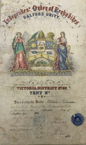
Certificate, William Richardson : Member of the Independent Order of Rechabites - Salford Unity, Victoria District No.82, Tent No.260, c. 1882
The Victoria District of Rechabites (District No. 82) was established in the 28th January 1861 with the transfer of Star of Australia Felix Tent No. 4 of the Tasmania District (which was established in Melbourne on the 25th January 1847) and Mount Alexander Tent No. 9 of the Tasmania District (began in Castlemaine on the 26th January 1860).In its heyday the Victoria Rechabites’ membership numbers grew and grew to the extent that there were at one stage in excess of 36,000 members associated with the Victorian Rechabites in the late 1800’s to early 1900’s covering approximately 250 operating Tents. Reference: Victoria RechabitesThis work forms part of the collection assembled by the historian Dorothy Rogers, that was donated to the Kew Historical Society by her son John Rogers in 2015. The manuscripts, photographs, maps, and documents were sourced by her from both family and local collections or produced as references for her print publications. Many were directly used by Rogers in writing ‘Lovely Old Homes of Kew’ (1961) and 'A History of Kew' (1973), or the numerous articles on local history that she produced for suburban newspapers. Most of the photographs in the collection include detailed annotations in her hand. The Rogers Collection provides a comprehensive insight into the working habits of a historian in the 1960s and 1970s. Together it forms the largest privately-donated collection within the archives of the Kew Historical Society. Illuminated certificate testifying that Brother William Richardson was enrolled as a member the Independent Order of Rechabites on the fourth day of September 1882. [William Richardson was the father of the historian, Dorothy Rogers]. The Star of Kew Tent No. 260 had been formed in 1882 as a branch of the Independent Order of Rechabites. W. H. Richardson was a founding member.rechabites, independent order of rechabites, star of australia felix tent no. 4, richardson family -
 Kew Historical Society Inc
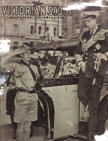
Magazine - Photograph (copy), Scout Association of Victoria, Cover, The Victorian Scout, December 1956, 1956
The Victorian Scout was a monthly magazine produced by the Victorian Branch of the Australian Scout Association.Photographic copy of the cover of the ‘The Victorian Scout’, depicting a Scout opening a door for Prince Phillip. The Scout in the photograph is George Porter, a 1st Kew Scout, who is shown saluting the Prince. ‘The Victorian Scout’ was a monthly magazine for scout leaders. During the Royal Visit of 1956, Scouts were selected to undertake official duties.The Victorian Scout / Melbourne, December, 1956 1st kew scouts, royal visit 1956 (melbourne), scout salutes prince phillip -
 Melbourne Tram Museum
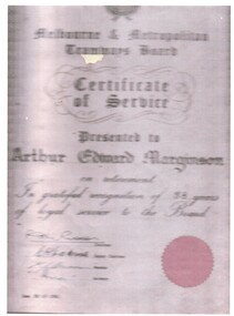
Document - Personal Papers, Ray Marginson, Inspector Arthur Marginson, 12/04/1960 12:00:00 AM
Set of three papers associated with Inspector Arthur Marginson; .1 - Image of MMTB Certificate of Service on rear is some information about his period of service - joined, employed for 38 years. .2 - Photos of Arthur in uniform and his garden. .3 - Image of a group of trammies at Kew Depot - identifies Arthur - no date.trams, tramways, personnel, kew depot, mmtb, inspectors -
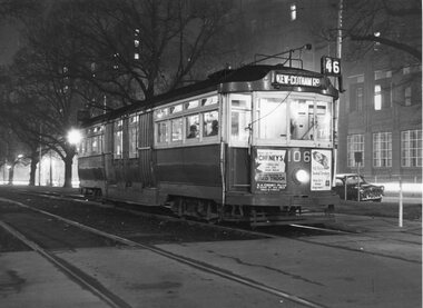 Melbourne Tram Museum
Photograph - Black & White Photograph/s, 1960's
Black & White Photograph of L class No. 106, possibly during the 1960's in Victoria Parade at night. Has the St Vincent's Hospital in the background. Tram has the destination of Kew Cotham Road, route 46 display. Has adverts for Cheney's used trucks and Kings "Old style" smoked Strasbourg meat.trams, tramways, l class, victoria parade, route 46, kew- cotham road, tram 106 -
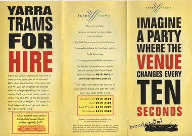 Melbourne Tram Museum
Pamphlet, Yarra Trams, "Imagine a party where the Venue changes every ten seconds", 2002
Pamphlet - 3 fold DL printed on gloss paper, titled "Imagine a party where the Venue changes every ten seconds", prompting the hire of trams for party's. Lists types of trams, conditions and what can be done. Gives contact details for Camberwell, Kew, East Preston and Southbank depots. Pamphlet c2002trams, tramways, yarra trams, charters, depots, passenger services -
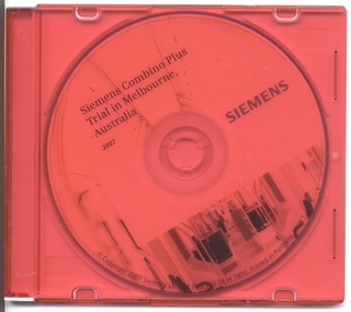 Melbourne Tram Museum
Film - Compact Diskette with video, Siemens, "Siemens Combino Plus Trial In Melbourne 2007", 2007
DVD made by Siemens as part of the demonstration visit of Combino Plus, C008 during 2007. Features interviews with passengers, views along the Melbourne - Kew via St Kilda Road route, lots of city views and night running, St Kilda foreshore, Balaclava Road. Length of production 5:06 minutes.trams, tramways, siemens, combino, melbourne, tram c008 -
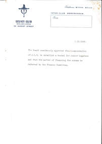 Melbourne Legacy
Document - Memorandum, Establishing hostels for Junior Legatees, 01/10/1942
An inter-club memorandum advising of the Board's approval to establish a hostel for Junior Legatees, later to be known as Holmbush, and ultimately as Blamey House. Holmbush was the first residential accommodation operated by Melbourne Legacy, and was established in 1942. It accommodated boys aged between 9 and 19, usually attending secondary school. In 1956, Holmbush became known as Blamey House. It was located not far from another Legacy home, Stanhope (1245 Burke Road). Residents of Holmbush and other Legacy homes were the children of deceased ex-servicemen. Sometimes residents at Legacy homes were both children of ex-servicemen and wards of state. In 1956, Blamey House, another Legacy children's home formerly in Beaumaris moved into the Holmbush property in Kew, and it was renamed Blamey House. Location 1942 - 1956? Address - Holmbush was located at 1267 Burke Road, Kew. Location: Kew Early record of the establishment of one of Melbourne Legacy's residences.Typed memo, black on white with blue letterhead outlining the agreement of the JLC board to proceed with the hostel for boys.residences, holmbush initial negotiations -
 Kew Historical Society Inc
Plan, Studley Heights Estate, 1936
Pru Sanderson, in her groundbreaking ‘City of Kew Urban Conservation Study : Volume 2 - Development History’ (1988), summarised the periods of urban development and subdivisions of land in Kew. The periods that she identified included 1845-1880, 1880-1893, 1893-1921, 1921-1933, 1933-1943, and Post-War Development. These periods were selected as they represented periods of rapid growth or decline in urban development. An obvious starting point for Sanderson’s groupings involved population growth and the associated economic cycles. These cycles also highlighted urban expansion onto land that was predominantly rural, although in other cases it represented the decline and breakup of large estates. A number of the plans in the Kew Historical Society’s collection can also be found in other collections, such as those of the State Library of Victoria and the Boroondara Library Service. A number are however unique to the collection.Subdivision plans are historically important documents used as evidence of the growth of suburbs in Australia. They frequently provide information about when the land was sold on which a built structure was subsequently constructed as well as evidence relating to surveyors and real estate and financial agents. The numerous subdivision plans in the Kew Historical Society's collection represent working documents, ranging from the initial sketches made in planning a subdivision to printed plans on which auctioneers or agents listed the prices for which individual lots were sold. In a number of cases, the reverse of a subdivision plan in the collection includes a photograph of a house that was also for sale by the agent. These photographs provide significant heritage information relating house design and decoration, fencing and household gardens.The ‘Studley Heights Estate’ on the South Side of Studley Park Road was launched in 1936. The seventeen allotments in the subdivision fronted Hyton Crescent and Studley Park Road.subdivision plans - kew, studley heights estate -
![Monnington [Estate], 1935](/media/collectors/550653872162f11fb04854aa/items/5907eb86d0ce0c14e82385c8/item-media/5907ecafd0ce0c14e823e87f/item-fit-380x285.jpg) Kew Historical Society Inc
Kew Historical Society IncPlan - Subdivision Plan, Monnington [Estate], 1935, 1935
Pru Sanderson, in her groundbreaking ‘City of Kew Urban Conservation Study : Volume 2 - Development History’ (1988), summarised the periods of urban development and subdivisions of land in Kew. The periods that she identified included 1845-1880, 1880-1893, 1893-1921, 1921-1933, 1933-1943, and Post-War Development. These periods were selected as they represented periods of rapid growth or decline in urban development. An obvious starting point for Sanderson’s groupings involved population growth and the associated economic cycles. These cycles also highlighted urban expansion onto land that was predominantly rural, although in other cases it represented the decline and breakup of large estates. A number of the plans in the Kew Historical Society’s collection can also be found in other collections, such as those of the State Library of Victoria and the Boroondara Library Service. A number are however unique to the collection.Subdivision plans are historically important documents used as evidence of the growth of suburbs in Australia. They frequently provide information about when the land was sold on which a built structure was subsequently constructed as well as evidence relating to surveyors and real estate and financial agents. The numerous subdivision plans in the Kew Historical Society's collection represent working documents, ranging from the initial sketches made in planning a subdivision to printed plans on which auctioneers or agents listed the prices for which individual lots were sold. In a number of cases, the reverse of a subdivision plan in the collection includes a photograph of a house that was also for sale by the agent. These photographs provide significant heritage information relating house design and decoration, fencing and household gardens.The first subdivision of Monnington took place in 1935. At that time, Monnington and 10 new allotments were offered for sale bordering Adeney and Marshall Avenues. In this subdivision plan, Monnington is one of 13 lots for sale. The subdivision created the irregular land holding of Monnington today. The excision of southwest corner of Monninton was caused by the need to have regular allotments facing the curve in Marshall Avenue.monnington - adeney avenue -- kew (vic.), subdivision plans -- kew (vic.) -
 Kew Historical Society Inc
Plan - Subdivision Plan, Altyre Estate, 1920, 1920
Pru Sanderson, in her groundbreaking ‘City of Kew Urban Conservation Study : Volume 2 - Development History’ (1988), summarised the periods of urban development and subdivisions of land in Kew. The periods that she identified included 1845-1880, 1880-1893, 1893-1921, 1921-1933, 1933-1943, and Post-War Development. These periods were selected as they represented periods of rapid growth or decline in urban development. An obvious starting point for Sanderson’s groupings involved population growth and the associated economic cycles. These cycles also highlighted urban expansion onto land that was predominantly rural, although in other cases it represented the decline and breakup of large estates. A number of the plans in the Kew Historical Society’s collection can also be found in other collections, such as those of the State Library of Victoria and the Boroondara Library Service. A number are however unique to the collection.The Kew Historical Society collection includes almost 100 subdivision plans pertaining to suburbs of the City of Melbourne. Most of these are of Kew, Kew East or Studley Park, although a smaller number are plans of Camberwell, Deepdene, Balwyn and Hawthorn. It is believed that the majority of the plans were gifted to the Society by persons connected with the real estate firm - J. R. Mathers and McMillan, 136 Cotham Road, Kew. The Plans in the collection are rarely in pristine form, being working plans on which the agent would write notes and record lots sold and the prices of these. The subdivision plans are historically significant examples of the growth of urban Melbourne from the beginning of the 20th Century up until the 1980s. A number of the plans are double-sided and often include a photograph on the reverse. A number of the latter are by noted photographers such as J.E. Barnes.The Altyre Estate was advertised for sale by auction in 1920. A colour lithograph in the State Library of Victoria, in contrast to this monochrome version, notes the proximity of the subdivision to the Auburn Heights Bowling Club and to a range of transport options. The subdivision included fifty-one allotments as well as the original house ‘Altyre’ in Barkers Road. This version includes the amounts paid as deposit on a number of lots.subdivision plans - kew, altyre estate – kew (vic), barkers road – kew (vic), walsh street – kew (vic), ross street – kew (vic), loxton street – kew (vic), mount street – kew (vic), auburn heights bowling club, altyre -
 Kew Historical Society Inc
Plan - Subdivision Plan, Summerhill Estate, 1920-1940
Pru Sanderson, in her groundbreaking ‘City of Kew Urban Conservation Study : Volume 2 - Development History’ (1988), summarised the periods of urban development and subdivisions of land in Kew. The periods that she identified included 1845-1880, 1880-1893, 1893-1921, 1921-1933, 1933-1943, and Post-War Development. These periods were selected as they represented periods of rapid growth or decline in urban development. An obvious starting point for Sanderson’s groupings involved population growth and the associated economic cycles. These cycles also highlighted urban expansion onto land that was predominantly rural, although in other cases it represented the decline and breakup of large estates. A number of the plans in the Kew Historical Society’s collection can also be found in other collections, such as those of the State Library of Victoria and the Boroondara Library Service. A number are however unique to the collection.The Kew Historical Society collection includes almost 100 subdivision plans pertaining to suburbs of the City of Melbourne. Most of these are of Kew, Kew East or Studley Park, although a smaller number are plans of Camberwell, Deepdene, Balwyn and Hawthorn. It is believed that the majority of the plans were gifted to the Society by persons connected with the real estate firm - J. R. Mathers and McMillan, 136 Cotham Road, Kew. The Plans in the collection are rarely in pristine form, being working plans on which the agent would write notes and record lots sold and the prices of these. The subdivision plans are historically significant examples of the growth of urban Melbourne from the beginning of the 20th Century up until the 1980s. A number of the plans are double-sided and often include a photograph on the reverse. A number of the latter are by noted photographers such as J.E. Barnes.The Summerhill Estate was a subdivision in Glen Iris of 24 ‘choice allotments’. The lots were primarily on both sides of Dillon Grove. Other lots at each end of the subdivision faced Margaret Street and Summerhill Road. It was from the latter that the subdivision took its advertised title. The lots were originally advertised for £10 deposit with 20 subsequent payments over five years. Pencilled on the printed plan is a change to the deposit required; a reduction to 20/-. Annotations indicate that the new deposits ranged from 30/- to 45/-. The most expensive lots faced Summerhill Road. This subdivision plan is unusual in that the front and rear of the card are for subdivisions in different localities.subdivision plans - glen iris, summerhill estate -
 Kew Historical Society Inc
Plan - Subdivision Plan, Birdwood Estate, 1920
Pru Sanderson, in her groundbreaking ‘City of Kew Urban Conservation Study : Volume 2 - Development History’ (1988), summarised the periods of urban development and subdivisions of land in Kew. The periods that she identified included 1845-1880, 1880-1893, 1893-1921, 1921-1933, 1933-1943, and Post-War Development. These periods were selected as they represented periods of rapid growth or decline in urban development. An obvious starting point for Sanderson’s groupings involved population growth and the associated economic cycles. These cycles also highlighted urban expansion onto land that was predominantly rural, although in other cases it represented the decline and breakup of large estates. A number of the plans in the Kew Historical Society’s collection can also be found in other collections, such as those of the State Library of Victoria and the Boroondara Library Service. A number are however unique to the collection.The Kew Historical Society collection includes almost 100 subdivision plans pertaining to suburbs of the City of Melbourne. Most of these are of Kew, Kew East or Studley Park, although a smaller number are plans of Camberwell, Deepdene, Balwyn and Hawthorn. It is believed that the majority of the plans were gifted to the Society by persons connected with the real estate firm - J. R. Mathers and McMillan, 136 Cotham Road, Kew. The Plans in the collection are rarely in pristine form, being working plans on which the agent would write notes and record lots sold and the prices of these. The subdivision plans are historically significant examples of the growth of urban Melbourne from the beginning of the 20th Century up until the 1980s. A number of the plans are double-sided and often include a photograph on the reverse. A number of the latter are by noted photographers such as J.E. Barnes.Bordering Burke Road, the Birdwood Estate included a subdivision of 34 lots on either side of Birdwood Street, Balwyn. Six of the lots faced Burke Road. At the other end of the subdivision a line would indicate that a creek once bordered the subdivision. Lots were advertised for sale at a low figure on five-year terms. Purchasers could pay off the balance in twenty quarterly instalments (i.e. over five years).subdivision plans - balwyn, birdwood estate -
 Kew Historical Society Inc
Plan - Subdivision Plan, Golf View Estate, c.1922
Pru Sanderson, in her groundbreaking ‘City of Kew Urban Conservation Study : Volume 2 - Development History’ (1988), summarised the periods of urban development and subdivisions of land in Kew. The periods that she identified included 1845-1880, 1880-1893, 1893-1921, 1921-1933, 1933-1943, and Post-War Development. These periods were selected as they represented periods of rapid growth or decline in urban development. An obvious starting point for Sanderson’s groupings involved population growth and the associated economic cycles. These cycles also highlighted urban expansion onto land that was predominantly rural, although in other cases it represented the decline and breakup of large estates. A number of the plans in the Kew Historical Society’s collection can also be found in other collections, such as those of the State Library of Victoria and the Boroondara Library Service. A number are however unique to the collection.The Kew Historical Society collection includes almost 100 subdivision plans pertaining to suburbs of the City of Melbourne. Most of these are of Kew, Kew East or Studley Park, although a smaller number are plans of Camberwell, Deepdene, Balwyn and Hawthorn. It is believed that the majority of the plans were gifted to the Society by persons connected with the real estate firm - J. R. Mathers and McMillan, 136 Cotham Road, Kew. The Plans in the collection are rarely in pristine form, being working plans on which the agent would write notes and record lots sold and the prices of these. The subdivision plans are historically significant examples of the growth of urban Melbourne from the beginning of the 20th Century up until the 1980s. A number of the plans are double-sided and often include a photograph on the reverse. A number of the latter are by noted photographers such as J.E. Barnes.The subdivision advertised as the Golf View Estate in Camberwell included 32 allotments bordering on Glen Iris Road, Smith Street (now Smith Road), St Andries Street and Camberwell Road. In the post-war period in which the subdivision took place, the significance of Camberwell as the ‘Heathiest of Suburbs’ because of the undulating nature of its terrain and its high altitude was promoted. The sales pitch aimed at attracting and selling to ‘Gentlemen’ who could take advantage of the nearby trams, which would take them to the ‘heart of the city’.subdivision plans - camberwell, golf view estate -
 Kew Historical Society Inc
Plan - Subdivision Plan, Bella Vista Estate, 1929
Pru Sanderson, in her groundbreaking ‘City of Kew Urban Conservation Study : Volume 2 - Development History’ (1988), summarised the periods of urban development and subdivisions of land in Kew. The periods that she identified included 1845-1880, 1880-1893, 1893-1921, 1921-1933, 1933-1943, and Post-War Development. These periods were selected as they represented periods of rapid growth or decline in urban development. An obvious starting point for Sanderson’s groupings involved population growth and the associated economic cycles. These cycles also highlighted urban expansion onto land that was predominantly rural, although in other cases it represented the decline and breakup of large estates. A number of the plans in the Kew Historical Society’s collection can also be found in other collections, such as those of the State Library of Victoria and the Boroondara Library Service. A number are however unique to the collection.The Kew Historical Society collection includes almost 100 subdivision plans pertaining to suburbs of the City of Melbourne. Most of these are of Kew, Kew East or Studley Park, although a smaller number are plans of Camberwell, Deepdene, Balwyn and Hawthorn. It is believed that the majority of the plans were gifted to the Society by persons connected with the real estate firm - J. R. Mathers and McMillan, 136 Cotham Road, Kew. The Plans in the collection are rarely in pristine form, being working plans on which the agent would write notes and record lots sold and the prices of these. The subdivision plans are historically significant examples of the growth of urban Melbourne from the beginning of the 20th Century up until the 1980s. A number of the plans are double-sided and often include a photograph on the reverse. A number of the latter are by noted photographers such as J.E. Barnes.Bella Vista (later ‘Malinda’) was a large Federation house designed by the architect Robert Haddon for Abel Hoadley. The house was built in 1902 and occupied the eastern corner of Thomas Street and Cotham Road. It was a single-storey, red brick house, set back from the road, featuring a central tower topped by a pagoda-like red terra cotta roof, on top of which was perched a very large terra cotta dragon. The Bella Vista subdivision of 1929 included Hoadley’s house as well as nine allotments facing Cotham Road and Alfred and Thomas Streets. In 1941, the land on which Hoadley’s house stood was to be further subdivided. Bella Vista is believed to have lasted until it was demolished in the 1980s.subdivision plans - kew, bella vista estate -
 Kew Historical Society Inc
Plan - Subdivision Plan, Plan of Subdivision of Crown Portion 71, Parish of Boroondara LP12509, Vol.1678, Fol.335526, Before 1930
Prue Sanderson, in her groundbreaking ‘City of Kew Urban Conservation Study : Volume 2 - Development History’ (1988), summarised the periods of urban development and subdivisions of land in Kew. The periods that she identified included 1845-1880, 1880-1893, 1893-1921, 1921-1933, 1933-1943, and Post-War Development. These periods were selected as they represented periods of rapid growth or decline in urban development. An obvious starting point for Sanderson’s groupings involved population growth and the associated economic cycles. These cycles also highlighted urban expansion onto land that was predominantly rural, although in other cases it represented the decline and breakup of large estates. A number of the plans in the Kew Historical Society’s collection can also be found in other collections, such as those of the State Library of Victoria and the Boroondara Library Service. A number are however unique to the collection.Subdivision plans are historically important documents used as evidence of the growth of suburbs in Australia. They frequently provide information about when the land was sold on which a built structure was subsequently constructed as well as evidence relating to surveyors and real estate and financial agents. The numerous subdivision plans in the Kew Historical Society's collection represent working documents, ranging from the initial sketches made in planning a subdivision to printed plans on which auctioneers or agents listed the prices for which individual lots were sold. In a number of cases, the reverse of a subdivision plan in the collection includes a photograph of a house that was also for sale by the agent. These photographs provide significant heritage information relating house design and decoration, fencing and household gardens.The six lots on the south side of Macartney Avenue, between Macartney Avenue and Daniell Place were part of a subdivision that occurred before 1930. The subdivision plan is of interest in that the original name of Daniell Place was Brougham Place. On the Plan, it is noted that lots 5 and 6 (currently 10 and 12 Macartney Avenue) had been sold for £13 each. By November 1930, the new six-roomed villa built on 12 Macartney Avenue was offered for immediate sale at a ‘sacrifice price’. Any offer in reason would be considered, although a £350 deposit was required.subdivision plans - kew, mount street - kew, brougham street - kew , macartney avenue - kew -
 Kew Historical Society Inc
Plan - Subdivision Plan, Mont Victor Hill Estate, 1936
Pru Sanderson, in her groundbreaking ‘City of Kew Urban Conservation Study : Volume 2 - Development History’ (1988), summarised the periods of urban development and subdivisions of land in Kew. The periods that she identified included 1845-1880, 1880-1893, 1893-1921, 1921-1933, 1933-1943, and Post-War Development. These periods were selected as they represented periods of rapid growth or decline in urban development. An obvious starting point for Sanderson’s groupings involved population growth and the associated economic cycles. These cycles also highlighted urban expansion onto land that was predominantly rural, although in other cases it represented the decline and breakup of large estates. A number of the plans in the Kew Historical Society’s collection can also be found in other collections, such as those of the State Library of Victoria and the Boroondara Library Service. A number are however unique to the collection.Subdivision plans are historically important documents used as evidence of the growth of suburbs in Australia. They frequently provide information about when the land was sold on which a built structure was subsequently constructed as well as evidence relating to surveyors and real estate and financial agents. The numerous subdivision plans in the Kew Historical Society's collection represent working documents, ranging from the initial sketches made in planning a subdivision to printed plans on which auctioneers or agents listed the prices for which individual lots were sold. In a number of cases, the reverse of a subdivision plan in the collection includes a photograph of a house that was also for sale by the agent. These photographs provide significant heritage information relating house design and decoration, fencing and household gardens.A preliminary plan for the Mont Victor Hill subdivision of 1936 which included 23 allotments bordering the Rimington Nursery in Mont Victor Road. The subdivision created allotments in Victor Avenue, Heather Grove and Burke Road. Bisecting the Estate and clearly marked on the plan is the Railway Reserve which at this stage was all that remained of the Outer Circle Railway. The auctioneers note on the plan that the subdivision was made possible by the order of Messrs S. H. Bennet & H. Wright, the executors of the Wills of S. Bennett & E. Foreman.mont victor hill estate, subdivision plans - kew -
 Kew Historical Society Inc
Plan - Subdivision Plan, J R Mathers & McMillan, Glenferrie Road, Cotham Road, Belmont Avenue, Stirling Street, 1910-1930
Pru Sanderson, in her groundbreaking ‘City of Kew Urban Conservation Study : Volume 2 - Development History’ (1988), summarised the periods of urban development and subdivisions of land in Kew. The periods that she identified included 1845-1880, 1880-1893, 1893-1921, 1921-1933, 1933-1943, and Post-War Development. These periods were selected as they represented periods of rapid growth or decline in urban development. An obvious starting point for Sanderson’s groupings involved population growth and the associated economic cycles. These cycles also highlighted urban expansion onto land that was predominantly rural, although in other cases it represented the decline and breakup of large estates. A number of the plans in the Kew Historical Society’s collection can also be found in other collections, such as those of the State Library of Victoria and the Boroondara Library Service. A number are however unique to the collection.The Kew Historical Society collection includes almost 100 subdivision plans pertaining to suburbs of the City of Melbourne. Most of these are of Kew, Kew East or Studley Park, although a smaller number are plans of Camberwell, Deepdene, Balwyn and Hawthorn. It is believed that the majority of the plans were gifted to the Society by persons connected with the real estate firm - J. R. Mathers and McMillan, 136 Cotham Road, Kew. The Plans in the collection are rarely in pristine form, being working plans on which the agent would write notes and record lots sold and the prices of these. The subdivision plans are historically significant examples of the growth of urban Melbourne from the beginning of the 20th Century up until the 1980s. A number of the plans are double-sided and often include a photograph on the reverse. A number of the latter are by noted photographers such as J.E. Barnes.A ‘proposed’ subdivision of the area in the vicinity of Cotham and Glenferrie Roads and Belmont Avenue depicts an alternate vision for how the land might be divided into lots. When comparing this undated proposed subdivision with a modern map, it is possible to see why the subdivision did not eventuate. The right-of-way shown in the plan as beginning in Belmont Avenue was to be extended much further, preventing the lower lots from being created in the proposed shapes. Identifying the date of the name change may assist in the dating of the proposed subdivision. In faded writing at the top of the plan is an annotation referring to ‘Abbotsford’ and Finlayson’s Agency.subdivision plans - kew, glenferrie road, cotham road, belmont avenue, stirling street -
 Kew Historical Society Inc
Plan - Subdivision Plan, Kewdene Estate, 1937-1939
Pru Sanderson, in her groundbreaking ‘City of Kew Urban Conservation Study : Volume 2 - Development History’ (1988), summarised the periods of urban development and subdivisions of land in Kew. The periods that she identified included 1845-1880, 1880-1893, 1893-1921, 1921-1933, 1933-1943, and Post-War Development. These periods were selected as they represented periods of rapid growth or decline in urban development. An obvious starting point for Sanderson’s groupings involved population growth and the associated economic cycles. These cycles also highlighted urban expansion onto land that was predominantly rural, although in other cases it represented the decline and breakup of large estates. A number of the plans in the Kew Historical Society’s collection can also be found in other collections, such as those of the State Library of Victoria and the Boroondara Library Service. A number are however unique to the collection.The Kew Historical Society collection includes almost 100 subdivision plans pertaining to suburbs of the City of Melbourne. Most of these are of Kew, Kew East or Studley Park, although a smaller number are plans of Camberwell, Deepdene, Balwyn and Hawthorn. It is believed that the majority of the plans were gifted to the Society by persons connected with the real estate firm - J. R. Mathers & McMillan, 136 Cotham Road, Kew. The Plans in the collection are rarely in pristine form, being working plans on which the agent would write notes and record lots sold and the prices of these. The subdivision plans are historically significant examples of the growth of urban Melbourne from the beginning of the 20th Century up until the 1980s. A number of the plans are double-sided and often include a photograph on the reverse. The advertisement for the ‘Kewdene Estate’ subdivision is pasted over a photograph of a property for sale. This is typical of the reuse of promotional materials in the period during, and subsequent to World War I. The subdivision included 14 lots bordered by Belmore Road, Birtles Street and Giles Street. On the other side of the subdivision [Glass] Creek is noted. The subdivision plan also shows part of the Outer Circle Railway and Deepdene Railway Station.subdivision plans - east kew, kewdene estate, belmore road -- kew east (vic.), giles street -- kew east (vic.) -
 Kew Historical Society Inc
Plan - Subdivision Plan, Goldthorns Hill Estate, 1925
Pru Sanderson, in her groundbreaking ‘City of Kew Urban Conservation Study : Volume 2 - Development History’ (1988), summarised the periods of urban development and subdivisions of land in Kew. The periods that she identified included 1845-1880, 1880-1893, 1893-1921, 1921-1933, 1933-1943, and Post-War Development. These periods were selected as they represented periods of rapid growth or decline in urban development. An obvious starting point for Sanderson’s groupings involved population growth and the associated economic cycles. These cycles also highlighted urban expansion onto land that was predominantly rural, although in other cases it represented the decline and breakup of large estates. A number of the plans in the Kew Historical Society’s collection can also be found in other collections, such as those of the State Library of Victoria and the Boroondara Library Service. A number are however unique to the collection.The Kew Historical Society collection includes almost 100 subdivision plans pertaining to suburbs of the City of Melbourne. Most of these are of Kew, Kew East or Studley Park, although a smaller number are plans of Camberwell, Deepdene, Balwyn and Hawthorn. It is believed that the majority of the plans were gifted to the Society by persons connected with the real estate firm - J. R. Mathers and McMillan, 136 Cotham Road, Kew. The Plans in the collection are rarely in pristine form, being working plans on which the agent would write notes and record lots sold and the prices of these. The subdivision plans are historically significant examples of the growth of urban Melbourne from the beginning of the 20th Century up until the 1980s. A number of the plans are double-sided and often include a photograph on the reverse. The Goldthorns Hill Estate subdivision was first put up for auction in 1925. The subdivision took its name from the mansion ‘Goldthorns’, shown on the plan between Normanby Road and Lady Loch’s Drive. Contemporary advertisements describe forty-three home sites being fro sale, yet only forty-one appear on this plan. Buyers were lured by the prospect of the proposed extension of the Burke Road tram to High Street. Discerning buyers were advised that only one house could be built per allotment, and that houses needed to be constructed of brick, stone or concrete and have a slate or tiled roof.goldthorns avenue -- kew east (vic.), lady loch drive -- kew east (vic.), argyle road -- kew east (vic.), lady brassey drive -- kew east (vic.), campbell street -- kew east (vic.), goldthorns -- kew (vic.), subdivisions -- kew east (viv.), goldthorns hill estate -
 Kew Historical Society Inc
Plan - Subdivision Plan, Jas R Mathers Son & McMillan, The Dale Estate, Deepdene, 1918
Pru Sanderson, in her groundbreaking ‘City of Kew Urban Conservation Study : Volume 2 - Development History’ (1988), summarised the periods of urban development and subdivisions of land in Kew. The periods that she identified included 1845-1880, 1880-1893, 1893-1921, 1921-1933, 1933-1943, and Post-War Development. These periods were selected as they represented periods of rapid growth or decline in urban development. An obvious starting point for Sanderson’s groupings involved population growth and the associated economic cycles. These cycles also highlighted urban expansion onto land that was predominantly rural, although in other cases it represented the decline and breakup of large estates. A number of the plans in the Kew Historical Society’s collection can also be found in other collections, such as those of the State Library of Victoria and the Boroondara Library Service. A number are however unique to the collection.The Kew Historical Society collection includes almost 100 subdivision plans pertaining to suburbs of the City of Melbourne. Most of these are of Kew, Kew East or Studley Park, although a smaller number are plans of Camberwell, Deepdene, Balwyn and Hawthorn. It is believed that the majority of the plans were gifted to the Society by persons connected with the real estate firm - J. R. Mathers and McMillan, 136 Cotham Road, Kew. The Plans in the collection are rarely in pristine form, being working plans on which the agent would write notes and record lots sold and the prices of these. The subdivision plans are historically significant examples of the growth of urban Melbourne from the beginning of the 20th Century up until the 1980s. A number of the plans are double-sided and often include a photograph on the reverse. A number of the latter are by noted photographers such as J.E. Barnes.The Dale Estate in Deepdene was made possible by the death of Robert Sparrow Smythe, Australian journalist, newspaper editor/owner and theatrical manager. Smythe lived in his residence ‘Highate’, Deepdene until his death in 1917. In the subdivision proposed one year later, before the end of the First World War, 18 allotments were to be created. The very fragmentary plan in the Society’s collection notes that a large weatherboard [house] will need to be removed. This may be Smythe’s own home. The proposed subdivision included allotments facing Burke and Whitehorse Roads and Dale Street. Bordering the subdivision is the Deepdene Station and the Outer Circle Railway Line. The clear directions on the plan indicate that in 1918 it was possible to travel by train from Deepdene to East Camberwell and Ashburtonsubdivision plans - deepdene, the dale estate -
 Kew Historical Society Inc
Photograph, Chipperfield's Boat House & Floating Pontoon, 1934
Living with natural processes was frequently a challenge to early European settlers and later residents of what was in the 1850s administered by the Borondara Road Board. This was compounded by the area being bounded on three sides by rivers (Yarra River, Koonung Creek and Gardiner's Creek). In 1849, the historian James Bonwick recorded that "our district [Kew] suffered considerably. Mr Wade speaks of 80 acres, out of 100 acres of his cultivated paddock, covered by water." Newspapers continued to describe major flooding in Kew in 1863, 1869, 1878, 1880, 1889, 1891, 1916 and 1934. While the construction of the Upper Yarra dam in 1957 reduced the levels of flowing downstream, local and riverine floods continue. A number of boat houses operated on both sides of the River Yarra at Kew. Chipperfield's Boat House was located on the Yarra near the corner of Kilby and Willsmere Roads.The Kew Historical Society's pictures and map collections testify to the impact of flooding in the district. They have historical importance in documenting the extent of flooding in the district and its affects on homes, services and recreation. Numerous photographs record flooding throughout the Twentieth Century.Floating pontoon at Chipperfield's Boat House where the canoes were stored, taken in 1934, presumably before the 1934 Flood. This area of the Yarra was shallow with a number of mid river sandbanks and a popular swimming area for locals.yarra river, chipperfield's boathouse, pontoon -
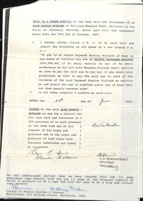 Ringwood and District Historical Society
Legal record, Alan Wieland's Will and two letters to and from the Talbots relating to it Melbourne ,1992
Alan Wieland was ummarried and left his estate to his nephew Raymond Wieland, his niece Pat Talbot and several others.including the Christian Blind Mission International in Kew, melbourne.5 pages of type with Yuncken and Yuncken Solicitors heading. including a letter to the Talbots. One page typed letter from Pat and Don Talbot to Yuncken and Yuncken re same will.