Showing 17198 items matching "bay-bridge"
-
 Clunes Museum
Negative - NEGATIVES
LEONARD CARTER WAS A PHOTOGRAPHER. HE ORININALLY LIVED IN CLUNES AND LATER IN APOLLO BAY. FAMILY HOME WHERE ROBERT CAMPBELL NOW LIVES.1 NEGATIVE OF THE ROMSEY SHOW - 1907local history, photography, photographs, negative, -
Clunes Museum
Negative - NEGATIVES
LEONARD CARTER WAS A PHOTOGRAPHER. HE ORIGINALLY LIVED IN CLUNES AND LATER IN APOLLO BAY. FAMILY HOME WHERE ROBERT CAMPBELL NOW LIVES.2 NEGATIVES OF PEOPLE AT A PICNIC, INCLUDING EDWIN CARTER.local history, photography, photographs, negatives, -
Clunes Museum
Negative - NEGATIVES
LEONARD CARTER WAS A PHOTOGRAPHER. HE ORIGINALLY LIVED IN CLUNES AND LATER IN APOLLO BAY. FAMILY HOME WHERE ROBERT CAMPBELL LIVES NOW.4 NEGATIVES OF THE CARTER FARMlocal history, photography, photographs, negatives, -
Clunes Museum
Negative - NEGATIVES
LEONARD CARTER WAS A PHOTOGRAPHER. HE ORIGINALLY LIVED IN CLUNES AND LATER IN APOLLO BAY. FAMILY HOME WHERE ROBERT CAMPBELL NOW LIVES.1 NEGATIVE OF CARTER FAMILY'S GRAVE HEADSTONElocal history, photography, photographs, negatives, -
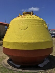 Queenscliffe Maritime Museum
Functional object - Buoys, pipeline
Large yellow marker buoys were used to indicate the gas pipeline which runs across Port Phillip Bay, Mordialloc to Altona.Two large yellow marker buoysmarker buoys, port phillip -
Port Melbourne Historical & Preservation Society
Photograph, Railway Pier, Melbourne, Victoria, c. 1900
Railway Pier opened in 1852 with the building of the Hobson's Bay Railway linking the city to Port Melbourne. In 1923 in was re-built as Station Pier.Sepia postcard of Railway Pier with shed on left in front of 2 ships . A sailing ship lies on the opposite side below the Finger Pier. A steamer being towed away from the pier by a tug .piers and wharves - railway pier, transport - shipping -
 Port Melbourne Historical & Preservation Society
Card - Parisma Business Card, c.2000
Card advertising Parisma KOUKLAN and her fashion consulting, alterations, dress-making & millinery business at 350 Bay Street, Port Melbourne Brown toned business card with a narrow darker border and text in black. business and traders - dressmaking, parisma, parisma kouklan, bay street -
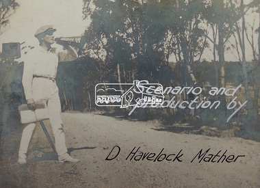 Eltham District Historical Society Inc
Document - Photograph, Donald Havelock Mather, Papers of Donald Havelock Mather of Kooringarama Films, Oct. 1927
These papers held by the National Library of Australia focus on the film “Borrowed Plumes” shot entirely in Eltham over ten days in October 1927. Some of the location shots are of Main Road near the bridge taken a year after the concrete bridge was opened.borrowed plumes (film), donald havelock mather, eltham, eltham south, kooringoorama films, main road, main road bridge, wingrove park -
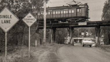 Greensborough Historical Society
Photograph - Photograph - Digital Image, Sherbourne Road Briar Hill, 1968_
A photograph of the old wooden rail bridge over Sherbourne Road Briar Hill, looking toward Eltham. Just past the bridge on the left is the old Hat Factory (now storage lockers). Dated by the HR Holden in photo; these were built in 1967.Digital copy of black and white photograph. rail bridge greensborough, sherbourne road briar hill -
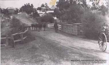 Greensborough Historical Society
Photograph, Main Street Greensborough, 1910c
From caption: "Main Street Greensborough - Early [20th] century. a traffic jam in Main Street Greensborough, as a herd of horses are driven over the old bluestone bridge. Photo taken by a lady driver waiting to cross the bridge, early this [20th] century".Black and white photograph, with description printed on lower right cornermain street greensborough, bluestone bridge -
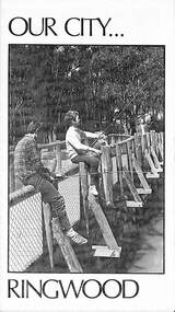 Ringwood and District Historical Society
Pamphlet, Our City - Ringwood (1972), 1972
Community information brochure issued in 1972 by Ringwood Council outlining local services, sporting, and cultural facilities. Includes names of Ward Councillors, and two City of Ringwood Free Tipping Vouchers valid until the end of 1973."Frontpiece: New bridge of pressure treated pine over Ringwood Lake." "Ringwood Must Grow, Not Go! With your money, Council provides these vital Services."rinx -
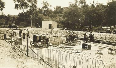 Ringwood and District Historical Society
Photograph, Building the old Ringwood baths in Ringwood St 1934
Black and white photograph. 2 copies- 1 large, 1 small.Typed below photograph, "Building the old Ringwood baths in Ringwood St. The car is in Ringwood St. and the bridge over the Mullum Creek can be seen. 1934". -
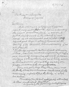 Ringwood and District Historical Society
Document, Council flood relief for Mullum Creek flood in Ringwood in 1934
Hand written letters to Ringwood Council re flood relief.Correspondence to Council from Ratepayers asking for flood relief resulting from the flood damage in the vicinity of Harrison Street bridge over Mullum Creek in 1934. -
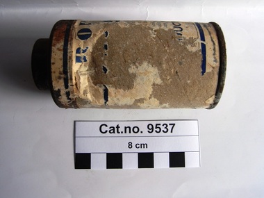 Coal Creek Community Park & Museum
Container, powder
Cardboard cylinder with metal base and metal shaker top. Remnants of paper label blue text on white on sides of cylinder. Still contains powder.Indistinct sections of text on side of cardboard. Powder in container.. '...cuts, wounds,........ to .... pint.......... twice this............... ....o large... ....s nor.... Registered Office ....inces Bridge.....'powder -
 Rutherglen Historical Society
Image, c1928
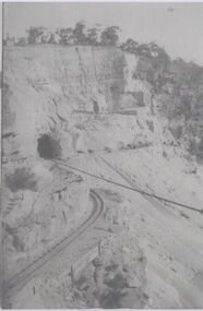
Photocopies of Hume Weir photographs 1928-29One of three black and white photographs, photocopied onto a single sheet of A4 paper. This one is of construction work on a cliff face, with train lines, tunnel and cable.Written on paper next to photo: "Detail of open cut for [illeg.]. Train lines for taking rock to crusher tunnel & stay ropes of suspension bridge showing"hume weir, suspension bridge, bridges, tunnels, construction -
 Bendigo Military Museum
Certificate - SERVICE CERTIFICATE NZEF, FRAMED, Bethany Gallery, c.WWI
Pte HARRY THOMPSON No 69437 New Zealand Expeditionary Force WW1. Refer 2027 for his service details. Illustrated certificate, brown & black ink printed on cream paper, mount in brown & green cardboard & brown frame.The Great War 1914 - 1918 Certificate of Service in the NZEF for Pte Harry Thompson 69437 Stamp on back: Bethany Gallery 116 Bridge St Bendigodocuments - certificates, military history-service records -
 The Beechworth Burke Museum
Photograph, Unknown c.1930s
This image shows Bethanga Bridge, which was constructed between 1927 and 1930 in Albury, NSW. The bridge was a necessity due to the building of the Hume Dam (Wier), 1919-1936. Bethanga Bridge is a long, nine-span, riveted-steel, variable depth, Pratt Truss road bridge of nine principal spans of 82 metres and a total length of 752 metres over the flooded valley of the Murray River, now part of Hume Reservoir. Because of its unique location, over the waters of a dam with the border running down the centre of the body of water, the Bethanga bridge is the only built structure shared by both New South Wales and Victoria. It was built 1.6 kilometres upstream of the dam and in 1961 was raised 300mm, with a concrete deck replacing the original wooden deck. The State Rivers and Water Supply Commission of Victoria and the New South Wales Department of Public Works were responsible for the construction works for the Hume Weir under the River Murray Waters Agreement. It is apparent that a similar joint arrangement was made for the construction of the Bethanga Bridge as part of the Hume Weir works.This photograph of the Bethanga Bridge is of historical significance as it showcases the architectural skills of Percy Allen and Vincent Packer. Additionally, it reveals the environmental landscape of the 1920s-1930s, is linked to the Hume Dam and both New South Wales and Victorian heritage. Unmounted black and white rectangular photograph. Reverse: 1997.3196 84-20-3bethanga, bethanga bridge, hume dam, pratt truss, murray river, hume weir, transportation -
 Ringwood RSL Sub-Branch
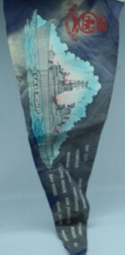
Souvenir Navy Pennant, HMAS Hobart
Blue Felt Pennant with a picture of the ship HMAS Hobart.Battle Honours or Ports of call - Bay City Norfolk Panama Canal Long Beach San Diego Port Hueneme Vancouver San Francisco Pearl Harbour Sydney Boston Mayport Fiji -
![Book - Novel, Clay, Bertha M, Love's hidden perils, [n.d.] [1940s?]](/media/collectors/641920217f0478323d8a47a8/items/6678d630ea633ba01096f9c0/item-media/668dc64b4d1cc58ad9c9bb82/item-fit-380x285.jpg) Linton Mechanics Institute and Free Library Collection
Linton Mechanics Institute and Free Library CollectionBook - Novel, Clay, Bertha M, Love's hidden perils, [n.d.] [1940s?]
224 p. : red/brown cover, section of original dust jacket pasted to front. Title and author's name hand printed on spine.fictionbertha m. clay, fiction, romance -
 St Kilda Historical Society
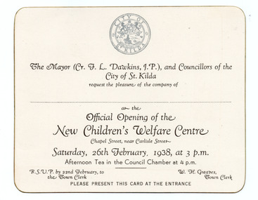
Ephemera - Invitation, Official Opening of the New Children's Welfare Centre, 1938
Unused invitation to the official opening of the City of St Kilda's Children's Welfare Centre, on Chapel Street, on 26 February 1938. The building was replaced in 1971 with a new Children's Centre and Maternal & Child Health Centre, which was later demolished and replaced in 2013 with the Bubup Nairm Children's Centre. Bubup means 'children' in local Boon Wurrung language, and Nairm is Port Phillip Bay: i.e. “ Children of Port Philip Bay”.White card, discoloured with age, printed in black with the City of St Kilda logo in bluechildren's welfare centre, city of st kilda -
 Eltham District Historical Society Inc
Album - Photograph, J.A. McDonald, Eltham-Diamond Creek Road, 21 Oct. 1953
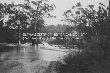
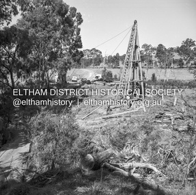
Floodwaters over Glen Park Bridge 21 October 1953Record of various Shire of Eltham infrastructure works undertaken during the period of 1952-1962 involving bridge and road reconstruction projects, sometimes with Eltham Shire Council Project Reference numbers quoted. It was during this period that a number of significant improvements were made to roads and new bridges constructed within the shire that remain in place as of present day (2022). In many situations, the photos provide a tangible visible record of infrastructure that existed throughout the early days of the Shire. The album was put together by or under the direction of the Shire Engineer, J.A. McDonald.infrastructure, road construction, shire of eltham, 1953-10-21, bridge construction, eltham north, floods, floodwater, glen park bridge -
 Eltham District Historical Society Inc
Album - Photograph, J.A. McDonald, Eltham-Diamond Creek Road, 21 Oct. 1953
Floodwaters over Glen Park Bridge 21 October 1953Record of various Shire of Eltham infrastructure works undertaken during the period of 1952-1962 involving bridge and road reconstruction projects, sometimes with Eltham Shire Council Project Reference numbers quoted. It was during this period that a number of significant improvements were made to roads and new bridges constructed within the shire that remain in place as of present day (2022). In many situations, the photos provide a tangible visible record of infrastructure that existed throughout the early days of the Shire. The album was put together by or under the direction of the Shire Engineer, J.A. McDonald.infrastructure, road construction, shire of eltham, 1953-10-21, bridge construction, eltham north, floods, floodwater, glen park bridge -
 Eltham District Historical Society Inc
Negative - Photograph, J.A. McDonald, Healesville-Yarra Glen Road, c.May 1958
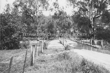
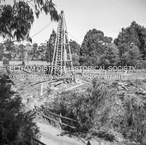
‘U’ slabs Paul Creek bridge, Tarrawarra Contractor WolfRecord of various Shire of Eltham infrastructure works undertaken during the period of 1952-1962 involving bridge and road reconstruction projects, sometimes with Eltham Shire Council Project Reference numbers quoted. It was during this period that a number of significant improvements were made to roads and new bridges constructed within the shire that remain in place as of present day (2022). In many situations, the photos provide a tangible visible record of infrastructure that existed throughout the early days of the Shire. The album was put together by or under the direction of the Shire Engineer, J.A. McDonald.infrastructure, shire of eltham, bridge construction, 1958-05, healesville-yarra glen road, paul creek bridge, w.e. wolf, tarrawarra -
 Eltham District Historical Society Inc
Negative - Photograph, J.A. McDonald, Laidlays Road, Arthurs Creek, April 1962
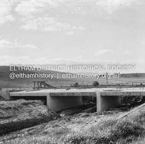
Bridge over Arthurs Creek Looking east April 1962Record of various Shire of Eltham infrastructure works undertaken during the period of 1952-1962 involving bridge and road reconstruction projects, sometimes with Eltham Shire Council Project Reference numbers quoted. It was during this period that a number of significant improvements were made to roads and new bridges constructed within the shire that remain in place as of present day (2022). In many situations, the photos provide a tangible visible record of infrastructure that existed throughout the early days of the Shire. The album was put together by or under the direction of the Shire Engineer, J.A. McDonald.1962-04, arthurs creek, bridge construction, infrastructure, laidlays road, shire of eltham -
 Eltham District Historical Society Inc
Negative - Photograph, J.A. McDonald, Laidlays Road, Arthurs Creek, April 1962
Bridge over Arthurs Creek Looking east April 1962Record of various Shire of Eltham infrastructure works undertaken during the period of 1952-1962 involving bridge and road reconstruction projects, sometimes with Eltham Shire Council Project Reference numbers quoted. It was during this period that a number of significant improvements were made to roads and new bridges constructed within the shire that remain in place as of present day (2022). In many situations, the photos provide a tangible visible record of infrastructure that existed throughout the early days of the Shire. The album was put together by or under the direction of the Shire Engineer, J.A. McDonald.1962-04, arthurs creek, bridge construction, infrastructure, laidlays road, shire of eltham -
 Eltham District Historical Society Inc
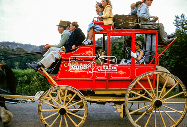
Photograph, Ersilac Parade, Main Road, Eltham, c.1960, 1960c
Heading south along Main Road approaching Bridge Street. Digital file only (Wes's 35mm)cobb and co, don muir collection, eltham, ersilac parade, horse drawn carriage, main road -
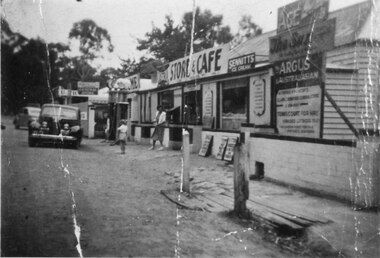 Halls Gap & Grampians Historical Society
Photograph - B/W
See 'Bridging the Gap' p65. Grampians Road Halls Gap.Group of shops with numerous advertising signs. A woman is leaving a shop, a young girl is standing in front of her. Two cars are parked in front of shops. Gravel road. Large gum trees in the background.buildings, shops -
 Eltham District Historical Society Inc
Photograph, 41 Antoinette Boulevard, cnr of Main Road, Eltham, c.May 2001
East side of Main Road near Diamond Creek BridgeRoll of 35mm colour negative film, 7 stripsAgfa HDC 200 plus-2eltham, streets, main road, antoinette boulevard -
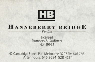 Port Melbourne Historical & Preservation Society
Card - Hanneberry BridgE Business Card, c.1990
Business card advertising Hanneberry Bridge Licenced Plumbers & Gasfitters.Grey business card with black text & HB logo.business and traders - plumbers, hanneberry bridge, 42 cambridge street -
Malmsbury Historical Society
Photograph (Item), Steam Trains On Bendigo Line, Malmsbury c1991
Associated with - M.H.S. Buildings - Road Bridge Over Railway Line