Showing 15302 items
matching a. greening
-
 Maldon Vintage Machinery Museum Inc
Pump - Centrifugal
Green painted self priming centrifugal pump bolted to a wooden base. Label attached warning of the need for safety guards. Primo Titan. Thompson Kelly & Lewis logo on front. Instruction plate on top. -
 Maldon Vintage Machinery Museum Inc
Chainsaw, Maker's name "Outboard Marine Australia Pty. Ltd
"Pioneer" chainsaw with green housing. Pull start, no chain. Compliance plate on back (see Below) second plate on top.Compliance plate on back "Pioneer Saws / Model / 450 / Serial No. A10778 / Division of Outboard Marine Australia Pty. Ltd. / Bankstown NSW". Cast in relief on side "Pioneer & Pine Trees".machinery, wood cutting -
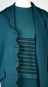 National Wool Museum
Textile - Jumper, Tina Knitwear, 1980-2000
Part of a selection of garments knitted by ‘Tina Knitwear’. Tina Knitwear was a successful made to order knitwear business in Brighton from the mid-1960s to around 2010, run by Assunta and Franco Liburti. This garment was owned and worn frequently by Assunta herself, as part of an ensemble. Daughter Melissa Persi writes: Our parents Assunta (Mum) and Franco (Dad) Liburti ran a successful made to order knitwear business in Brighton from the mid-1960s to around 2010. Assunta was affectionately known to her family as Assuntina, therefore the business was named "Tina Knitwear" after her. Assunta and Franco were born in the beautiful seaside town of Terracina in Italy in 1933 and 1930 respectively. As was so common in Italy in the 1950s, Assunta who was in her late teens and early twenties learnt the intricate skills of machine knitting, dressmaking and pattern making. Franco on the other hand, learnt the building trade with his 2 brothers and specialised in bricklaying and tiling. As was so common after the war, Assunta and Franco yearned for a better life so they decided that they would get engaged and then migrate to Australia to be married and raise their family in Australia, a land of much opportunity which they no longer felt their beloved Italy held for them. Assunta migrated to Australia first in 1957 and later Franco joined her in 1958 where they were married. For the first few years, Franco (also known as Frank) worked as bricklayer /tiler on buildings such as the Robert Menzies building at Monash University in Clayton and various buildings in the Melbourne CBD. Assunta on the other hand put her machine knitting skills to use working in factories doing piece machine knitting for various knitwear companies. The hours were long, the conditions were difficult, and travel was onerous without a car. After their 2 older children were born, it was decided that dad would leave the building trade and they would start their own made to order knitwear business. That way they could work from home and raise their family together. Mum taught dad everything he needed to know so he could operate the knitwear machinery. They purchased COPPO knitting machines from Italy and a Linking machine from Germany. Initially they had a knitwear shopfront in Bay Street Brighton where a store assistant would take the orders and client’s measurements and Assunta would then make the garments from a small workshop in their home. Unfortunately, the assistants were not skilled dressmakers and often measurements and orders were incorrectly taken. Assunta being the perfectionist and highly skilled machinist that she was, decided that she needed to oversee the entire process from meeting the client, to taking their order, right thru to the fittings and completion of the garment. It therefore made sense that they should close the shop front and run their business from their own home in Brighton and hence “Tina Knitwear” was born. Together, for more than 40 years they ran their very respected and successful business and were well known in the Bayside area. They specialised in made to order knitwear for both men and women using mainly pure wool (from Patons, Wangaratta Mills, Japan and Italy) but also lurex and estacel. Over those years, many of their clients became their close friends. It wasn't unusual for clients to come to order garments and then end up in the kitchen chatting over a cup of Italian espresso coffee and homemade biscuits. Some of their clients were especially memorable and became lifelong friends. Mrs Connell was a dear friend of mum’s, each year she would buy tickets for the “Gown of the Year” fashion show. She would insist on taking Assunta and her 2 daughters so that we could see the latest fashions. Then there was their dear friend Ms Griffiths. She had been a Matron nurse at the Queen Victoria Hospital when she met my parents in the 1970s. She returned to live in New Zealand in the 1980s but came back to Melbourne every year to stay for 2 weeks with the sole purpose of visiting my parents (she adored them) and order garments. For those 2 solid weeks, mum and dad would only knit for Ms Griffiths and she would go back to New Zealand with at least 5 or 6 new outfits. I actually think she enjoyed mum’s homemade pasta almost as much as her new clothes! Over the years, my parents learnt to speak English very well given that majority of their clients were not Italian speaking. Their oldest child John born in 1960 learnt to speak English with the help of those clients who were such a big part of our childhood. Mum and dad always went above and beyond to ensure their clients were satisfied. Mum was an absolute perfectionist and it showed in her attention to detail and the quality of their beautiful work. You only need to look at the garments that have stood the test of time or speak to their clients to know that this is true. Their clients would always comment on how well their clothes would last and much of their clients came via word of mouth and recommendations. Occasionally there would be disagreements because mum had found an error in dad's knitting (either a wrong stitch or a sizing mistake mainly) and would ask him to redo a piece, he would argue back saying that it was fine, but we always knew who would win the argument and that the piece would get remade! Similarly, we recall discussions where mum would ask dad to find a particular colour of wool in the garage where the stock was kept. He would try to convince her that they were out of stock of that colour and that the client should choose a different colour. She would insist they had it and then after hours of searching, he would return into the house sheepishly holding the wool! Our childhood is full of beautiful memories of mum and dad always being present, clients coming and going, mum humming her favourite songs as she worked often late into the night and sometimes, we even fell asleep to the hum of the machinery. They put their heart and soul into "Tina Knitwear" and took pride in providing only the best quality garments for their clients. In Italian there is a saying “lei ha le mani d’oro” which literally translated means “she has hands of gold”. Franco enjoyed his work but for Assunta, it was more than just work and there is no better way to describe her skills, passion and dedication to her machine knitting… she truly did have “hands of gold”. We will forever be grateful that our parents’ life journey gave us the opportunity to live in a home filled with creativity, dedication and passion, amazing work ethic and mutual respect, lifelong friendships and a lifetime of love. Forrest green long sleeved crew neck jumper with black horizontal stripes on lower half. Button at the back of neck. knitwear, clothing, italy, migrants, brighton, knitting machine, linking machine, garments, business, family, community -
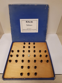 Vision Australia
Leisure object - Object, Solitaire, 19
Also known as Peg solitaire or Brainvita, this one player game was a favourite in the court of Louis XIV. This board is based on the English design with peg holes in the shape of a cross. European boards are circular with peg holes placed to the edge. Regardless of shape, the game is played the same. Pegs are placed in the board, leaving an empty spot in the middle. Using this space, a player must move any peg left, right, up or down over an adjacent peg, thereby landing in the space and removing the peg that has been passed over. Pegs are progressively moved (and removed) from the board until the single remaining peg is placed in central spot initially left vacant. RNIB Catalogue no: 9197. 1 wooden board in blue box 32 black pegs, 1 green peg and 1 printed/Braille booklet. recreation, games -
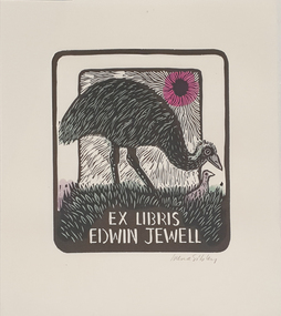 Federation University Art Collection
Work on paper - Bookplate, ‘Ex Libris Edwin Jewell’ by Irena Sibley
After a quiet period, interest in bookplates in Australia began to increase in the early 1970s, Entrepreneurial art and book collectors such as Edwin Jewell and others commissioned multiple Bookplate designs from a range of well known fine artists. At a 1997 meeting in Melbourne of the Ephemera Society of Australia Edwin Jewell and others announced the formation of the Australian Bookplate Society. The society was instrumental in promoting the art of the bookplate through establishment of the Australian Bookplate Design competition..1 An adult emu with chick is depicted standing in grass under the suns rays .2 As above but with green and pink shadingPencil signature Irena Sibleybookplate, printmaking, australian bookplate design award, keith wingrove memorial trust, emu -
Canterbury History Group
Drawing - Illustration, Winson Green Road residents, Caffin, Lyle, 1990
Drawing by Lyle Caffin listing the residents of the houses in Winson Green Road about 1920 when she lived at no. 8.canterbury, winson green road, drawing -
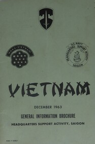 Diamond Valley Vietnam Veterans Sub-Branch
Booklet - n/a, General Information Guide, Vietnam, December 1963, 22/3/2009
Booklet detailed general information for US Forces in Vietnam and, often this information was imparted onto Australian Forces.Some elements of the General Information form the conditions under which Australian Forces lived and served whilst in Vietnam.Green light cardboard cover with black text and logos on front cover; a map showing Saigon and surrounds on back cover.Three logos: Military Assistance Command, Vietnam; MAAG-Vietnam; U.S. Navy, Headquarters Support Activity, Saigonvietnam, vietnam war, diamond valley vietnam veterans sub branch, us forces -
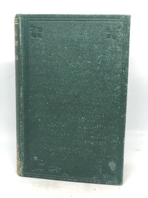 Kilmore Historical Society
PHYSICAL GEOGRAPHY OF AUSTRALIA, Manual of Physical Geography of Australia, 1873
Green leather cover with gold writing on spine 'Physical Geography of Australia' 167 pages ; 17 cm ; Illu ; indexHandwritten inscription on first page '137' Stamp on multiple pages 'Kilmore Mechanics Institute'geography, kilmore mechanics institute library. -
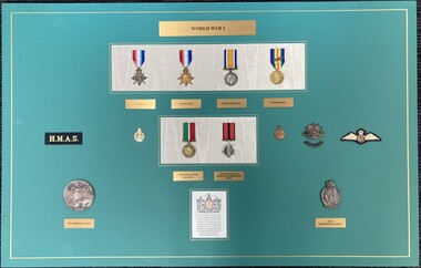 Melbourne Legacy
Medal, World War 1
One of a series of four boards of mounted replica medals of the Australian Defence Forces. This board shows medals pertaining to World War 1. Replicas include the 1914 Star, 1914-1915 Star, British War Medal, Victory Medal, Mercantile Marine War Medal, 80th Anniversary of Armistice Remembrance Medal. Also a WW1 Memorial Plaque and Anzac Commemorative Medal. There is a cloth patch embroidered 'H.M.A.S.' and one with embroidered Air Force wings from the Australian Flying Corps. The text reproduced at the base accompanied the WW1 memorial plaques. The boards were on display in the Melbourne Legacy Foyer cabinets until June 2017.A record that Legacy holds some war memorabilia as Legatees were once solely returned servicemen.Replica medals from World War 1 mounted on silk inserts into green boards plus additional badges and medallions.Title inscribed in brass plaques say World War 1, 1914 Star, 1914-1915 Star, British War Medal, Victory Medal, Mercantile Marine War Medal, 80th Anniversary of Armistice Remembrance Medal, WW1 Memorial Plaque and Anzac Commemorative Medal. Cloth badge embroidered 'H.M.A.S.' and one 'AFC'.world war one, medals -
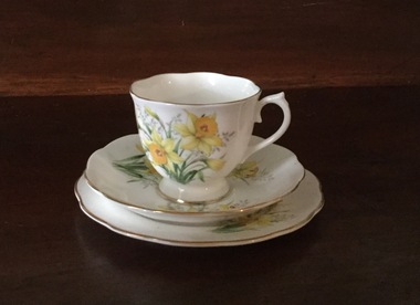 Mont De Lancey
Functional object - Cup and saucer, Royal Albert, c1920's
From the home of Mrs. Nell Sebire, 2nd wife of Thomas.Fine china floral cup, saucer and plate with gold trim with daffodils and green leaf design. Three piece set."Royal Albert bone china England friendship series of 12 daffodil'.cups and saucers, tableware, drinking cups -
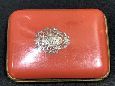 Mont De Lancey
Purse, Circa 1893
Gift to Florence E. Feore by her grandfather on her 13th birthday, 14th February 1893.Small orange enamel purse, with silver decoration on outer case. Small inner compartment lined with blue/green satin.Initials "F.E.F." on outer casepurses -
Friends of Ballarat Botanical Gardens History Group
Work on paper - Delavay's Oak, Research and References, 21/11/2011
Because the Delavay Oak is so rare and found in the Ballarat Botanical Gardens, this is valuable information.The history and habit of Delavay's oak remains important. 7 pages of computer print-out with copies. 1 photocopy is black print on green from Journal de Botanique.Nonedelavay's oak, quercus delevayi, ballarat botanical gardens, john garner, doctor, john garner collection, journal de botanique, pere (father)jean marie delavay, oak icra checklist, a.franchet, french missionary, sisters of st john of god, yunnan china, gardens, ballarat -
The 5th/6th Battalion Royal Victoria Regiment Historical Collection
Book, Pictorial History of Australia at War 1939 - 1945 5 Volumes, 1958
Set of 5 volumes bound with green material covers title "Pictorial History - 1939 - 1945 " gold lettering on spine. "Pictorial History - 1939 - 1945 "regimental property, ww2, pictorial history -
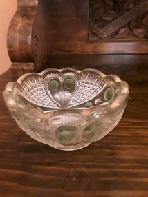 Mont De Lancey
Functional object - Glass Bowl, Unknown
A small round cut glass decorative bowl with a green circular pattern and gold trim around the top scalloped edge.bowls, containers, objects, decorative objects -
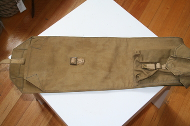 Trafalgar Holden Museum
Functional object - Rifle bag, 1946
Military rifle carrier with ammunition pocket on side as issued to troops in 1947Made by GMH 1946 for Military useArmy green canvas rifle carrier with ammunition pocket on side. Canvas cover over opening with brass buckle to close.GMH&Co 1946military, rifle carrier, canvas -
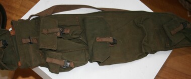 Trafalgar Holden Museum
Functional object - Rifle bag
Used during WW2 canvas water proof carry bag for rifle. t As made and sold by General Motors HoldenArmy green canvas rifle bag with shoulder strap and three ammunition pouches. Pouches fastened by tan leather straps.rifle bag, military -
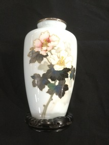 Mont De Lancey
Cloisonne - Vase
Purchased by Mr. & Mrs. H. N. Lord in Japan in 1960. The Japanese word for cloisonne ware is SHIPPO or seven treasured ware. It is an ancient technique for decorating metalwork objects. The resulting objects can also be called cloisonné. The decoration is formed by first adding compartments or cells to the metal object. This is done by soldering or sticking silver or gold wires or thin strips placed on edge. These are visible in the finished piece, separating the different compartments. Coloured enamel is the usual filling for the cells. Cloisonné enamel objects are worked on with enamel powder made into a paste, which then is fired in a kiln. In older times inlays of cut gemstones were often used. They were decorated with geometric or schematic designs, with thick cloison walls. Pale blue Japanese Cloisonne vase with peony flower design in pink and white with green leaves on black wooden stand. vases -
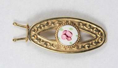 Wodonga & District Historical Society Inc
Decorative object - Gold toned hair clip from the Sarah Coventry jewellery range, c. 1970s -1980s
Sarah Coventry Pty. Ltd. was a North American jewellery company that was established in 1949 by the Stuart family as part of Emmons Jewelry, Inc. It began operations in England and Australia in 1968, and in Australia it moved from Carlton in Melbourne to Wodonga in 1969. The premises were originally on High St. in Wodonga, but a new warehouse was built in Melbourne Rd. later in 1969. It was a direct selling jewellery business using a party-plan model similar to Tupperware and Avon. The sales reps or 'Hostesses' were provided with jewellery samples in demonstration kits, which they displayed at jewellery parties in their homes. The designs for jewellery such as brooches, necklaces, earrings, chokers and bracelets were purchased from freelance designers and jewellery manufacturers rather than in-house designers. In 1979 Sarah Coventry Pty. Ltd. in Wodonga was bought by three Australian businessmen, including Wodonga local Jim Sawyer, and continued to sell jewellery under the name "Sargem Pty. Ltd”, for several more years in the 1980s. As part of the Sarah Coventry collection, the hair clip has local significance with the decentralised commercial development of regional centres such as Wodonga in NE Victoria, as well as national and international significance from the perspective of social and economic developments for women after World War II. The direct selling party-plan business model Sarah Coventry was based on is also considered the first of its kind for jewellery.Gold toned metal hair clip with a circular enamel inlay with a flower petal motif surrounded by five green dots."SARAH" - thought to be first used in 1951 on the back of the circular decorative element.sarah coventry, jewellery, wodonga, costume jewellery, vintage fashion jewellery, hair clip, hair slide -
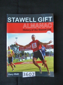 Stawell Historical Society Inc
Book, Gary Watt, Stawell Gift Almanac, History of the Stawell Gift - Previously Cat No 3602, 2008
Card cover with blue and red strips above a colour photograph of runners finishing a race, above a dark green strip.Stawell Gif (Grey Print) Almanac (Clear Print) History of the Stawell Gift (Black Print) Garry Watt (Grey Print)stawell athletics sport -
Port Melbourne Historical & Preservation Society
Container - Gin Bottle, Olive Green Glass, 1880 - 1920
Was found by donor c 1985 when digging foundations for an extension to his home at 167 Princes Street (The area was adjacent vacant block on the south side of 167, one of the properties demolished in the 1970s to put in the Graham Street overpass).Glass hand made bottle, deep olive green, irregular in shape, four sided gin bottle. Date unknown.social activities -
Coal Creek Community Park & Museum
Domestic object - Tobacco Tin, Lloyd & Sons, Richard
Rectangular metal container with hinged lid for tobacco, main colour pale green with floral graphic and blue and white text.Mark on lid: SKIPPER BRAND BRITISH NAVY CUT, and other. -
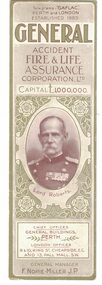 Linton and District Historical Society Inc
Bookmark, General Accident Fire & Life Assurance
The bookmark was part of a miscellaneous collection of items owned by Mrs Stella Surman.Decorative green and white bookmark, produced as an advertisement for an insurance company. The bookmark features a photograph of and information about Lord Roberts.Text: " GENERAL / ACCIDENT / FIRE & LIFE / ASSURANCE / CORPORATION, LTD. "bookmarks, advertising, surman collection -
Linton Mechanics Institute and Free Library Collection
Book - Novel, Boothby, Guy, Dr. Nikola's Experiment by Guy Boothby
Hardcover book with dark green cover. 340 pages. Twenty full page illustrations by Sydney Cowell. Colonial Edition.fictionguy boothby, sydney cowell, fiction -
Linton Mechanics Institute and Free Library Collection
Book - Novel, Wherry, Edith, The Red Lantern by Edith Wherry, 1919
Romance novel.Hardcover book, 247 pages. Book has a green cover with black line borders. Ear of wheat in centre of cover.fictionRomance novel.edith wherry, romance, fiction -
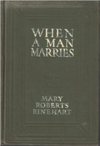 Linton Mechanics Institute and Free Library Collection
Book - Novel, Rinehart, Mary Roberts et al, When A Man Marries by Mary Roberts Rinehart, 1909
Romance novel.Hardcover book, 356 pages. Book has an olive green cover with white text.Illustrations by Harrison Fisher and Mayo Bunker.fictionRomance novel.mary roberts rinehart, romance, fiction -
Linton Mechanics Institute and Free Library Collection
Book - Novel, Wren, Captain P. C. (Percival Christopher Wren), The wages of virtue, 1920 [First published 1916]
301 p. : green cover embossed with pattern of leaves. Cloth on spine missing, title hand written along spine.fictionfiction, captain p. c. wren (percival christopher wren) -
 Bendigo Historical Society Inc.
Administrative record - Bendigo Tailings Company Invoice Book, 1911 - 1913
BHS CollectionGreen cover, maroon binding on spine, 93 pages of which 11 are used. Dates of invoices from 1911 to 1913. 'Bendigo Tailings Company, No Liability, Invoice Book" bendigo, gold mining, tailings, bendigo tailings company, invoice -
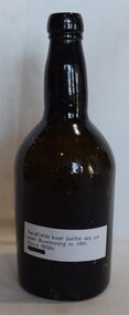 Buninyong Visitor Information Centre
Container - Bottle, Goldfields Beer Bottle
Wide dark green bottle with long, slightly bulging neck and a steep inverted conical base. Mid-nineteenth century.Paper label attached to bottle reads: 'Goldfield's beer bottle dug up near Buninyong in 1991. Circa 1850s.'bottles, brewing -
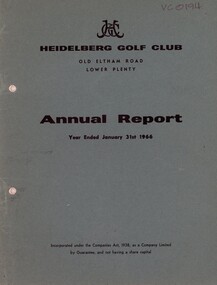 Heidelberg Golf Club
Booklet - Annual Report, Heidelberg Golf Club, Heidelberg Golf Club, Lower Plenty: Annual report, Year ended January 31st, 1966, 1966
Annual report of the Heidelberg Golf Club. Includes annual report, balance sheet and accounts to 31/01/1966. Annual General Meeting held April 1966.Annual reports found in this collection begin in 1933-34.28 page document. Typed text and black and white photographs. Bound in dark green card cover. 3 copies. annual reports, financial reports -
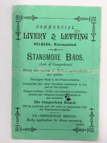 Warrnambool and District Historical Society Inc.
Document, Business Advertising Livery & Letting, 1882
The Warrnambool Amateur Turf Club was first formed in September 1859, but didn't become a properly constituted club until April 1873, when a meeting was held at the Commercial Hotel, now the Whaler's Inn, and a committee was elected.Part of the present racecourse of 100 acres was set aside as a racing and recreation reserve in August 1855. It is one of the finest racecourses in Australia, ringed by the gentle slopes of a huge basin.The first race meeting was held on the course in August 1858. The Warrnambool Racing Club has managed racing at Warrnambool since it was formed on 5 April 1873.Apart from a number of smaller meetings held throughout the year, the feature of racing in the district is the Grand Annual Steeplechase. The first steeplechase over the now famous cross-country course was run on 13th June 1872 then known as the Grand Annual Steeplechase. The paddocks now know as Brierly and Granters were first used on that date. The course, over four miles, was made up of different kinds of jumps including a stone wall, a log fence, a ditch and parapet, a paling fence and numerous post and rails.This card has Warrnambool Racing Club acceptances on one side for the Winter steeplechase meeting for the June meeting in 1882. Stansmore Bros. operated livery stables near the Commercial Hotel in Liebig Street around this time having commenced their business in Camperdown.They later moved to Kepler Street. The Stansmore family had a long association with the racing and agricultural industry in the Camperdown and Heytesbury areas. This little card has links to one of Warrnambool's premier sporting events and a local business which has strong family connections in the district.Small green card with black text on front and back. Edged with small lined border. The back has a racing schedule.Commercial Livery & letting Stables Warrnambool.Stanmore Bros. Warrnambool Racing Club, J.A Archibald Secretary WRCwarrnambool,, commercial livery & letting stables, stansmore brothers stables, warrnambool racing club 1882