Showing 30566 items
matching the hill
-
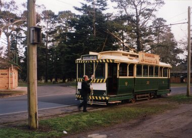 Ballarat Tramway Museum
Photograph - Colour Photograph/s, Earl Ewers, 26/09/1992 12:00:00 AM
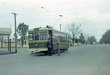
Yields information about the BTPS 21st Anniversary celebrations which involved running a "all day" service. First tram out, early am.Colour Photograph of BTM tram No. 33 being reversed by Gavin Young at the Gardens Loop on 26/9/1992 as part of the 21st Anniversary celebrations. Tram has Sovereign Hill ad on the side, and showing "Gardens via Drummond North". See also Reg Item 4056.1 > 4056.7 and September 1992 Fares Please!21st anniversary, btm, wendouree parade, gardens loop, tram 33 -
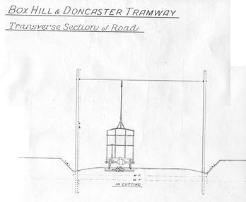 Ballarat Tramway Museum
Document - Photocopy, "Box Hill - Doncaster Tramway, Transverse Section of Road", c1990?
Photocopy of a drawing showing the proposed transverse sections of the Box Hill to Doncaster Tramway. Drawing prepared at a scale of 4 feet to the inch. Shows the dimensioned sections with the tramcar, poles, sleepers and metal ballast in cutting and in bank (fill). Photocopy larger than original drawing. Has part of a stamp in the lower right hand corner.trams, tramways, box hill, doncaster, plans, sections -
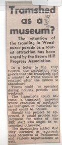 Ballarat Tramway Museum
Newspaper, The Courier Ballarat, "Tram shed as a Museum?", 10/12/1970 12:00:00 AM
Newspaper clipping from The Courier, Ballarat, 10/12/1970 about the retention of the tramline in Wendouree Parade as a tourist attraction has been urged by the Brown Hill Progress Association. Notes suggested times of operation, depot could be a mechanical transport museum and intended to approach local Members of Parliament and various organisations as well.In pencil in top right hand corner '10/12/70'trams, tramways, brown hill progress association, museum establishment, tram preservation -
 Ballarat Tramway Museum
Newspaper, The Courier Ballarat, "Plan for return of Trams", 16/01/1980 12:00:00 AM
Newspaper clipping from The Courier, Ballarat, Wednesday 16/1/1980, titled "Plan for return of Trams". Item describes a handwritten proposal that had been sent to the City of Ballarat by a Mr Daryl Jones for a tramway from the Botanic Gardens to Sovereign Hill. Proposals to be reviewed by Council, who had not heard of them before.tramway proposals, sovereign hill -
 Ballarat Tramway Museum
Slide - 35mm slide/s, Travis Jeffrey, late 1960's or early 1970's
Agfa plastic mount (blue base, white cover) with a photo of Bendigo No. 2 at Quarry Hill terminus. Photo taken late 1960's early 1970's. No. 2 has the destination of Eaglehawk and on the tram two SEC roof advertisements, "Electric Cooking Matchless" and "Everything's fine in my all electric kitchen"."BES 40" in penciltramways, trams, bendigo, quarry hill, tram 2 -
 Ballarat Tramway Museum
Negative, Travis Jeffrey, 5/08/1962 12:00:00 AM
Colour Negative No. N411, of the Bendigo No 11 at Quarry Hill terminus, with the conductor standing by the front door of the tram and a passenger appearing to get some money out of a wallet. Tram has the destination of North Bendigo. Photo taken possibly on 5/8/1962. Colour laser printed copy of image stored in box 73.In red pen on folder that contained negative, "NR90B" and "5 Aug 62". trams, tramways, bendigo, quarry hill, crews, tram 11 -
 Ballarat Tramway Museum
Photograph - Black & White Photograph/s, mid to late 1950's
Black and white photograph of Bendigo 25, late 1950's crossing the highway at Charing Cross and about to enter Mitchell St. Tram has the destination of Quarry Hill. In the background is City Club Hotel. On the right hand side of the photograph is a direction sign and tram stop sign. Photographer unknown - see history of object.In the rear in ink "Bendigo"trams, tramways, bendigo, charing cross, mitchell st, quarry hill, tram 25 -
 Ballarat Tramway Museum
Photograph - Digital image, 1970s
Yields information about the Victoria St route and Bakery Hill.Digital image, black and white, of No. 13 climbing Bakery Hill towards Princess St on the Victoria St route, in Victoria St, with two people waiting for the tram to pass. Photo taken by Peter Bruce 1970's and 1971, prior to the closure of the Ballarat tramway system. Peter's Title of image: "No. 13 Victoria St"trams, tramways, victoria st, bakery hill, tram 13 -
 Ballarat Tramway Museum
Photograph - Black & White Photograph/s, Keith Kings, 29/12/1947 12:00:00 AM
Black and White print contained within the Wal Jack Bendigo and Geelong Album, see Reg Item 5003 for more details. Photograph of No. 26 in Mitchell St Bendigo, outbound to Quarry Hill with the Terminus Hotel in the background. Wal's album notes date the photo as 29-12-1947. Photo by Leon Marshall Wood. In ink on rear "SEC of Victoria, Bendigo, Bogie drop centre car No.26 acquired from M&MTB 1947, ex MMTB "C" class, owned originally by Hawthorn Tramways Trust". In pencil, different hand writing "ex 135" and in bottom left hand corner, Leon Marshall Wood photo number "SEC 22" written in.trams, tramways, bendigo, bogie trams, quarry hill, mitchell st, tram 26 -
 Otway Districts Historical Society
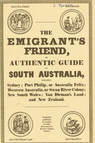
Book, Reader's Digest Services Pty Limited, The emigrant's friend, or authentic guide to South Australia, 1974
This book is a replica of a booklet printed in the United Kingdom. In 1848, when it was published in London as a guide to prospective emigrants, 23,904 people left the United Kingdom for the Australian colonies and New Zealand. In 1847, with the failure of potato crops threatening famine in Ireland and growing political unrest at home, the British Government had once again encouraged emigration by offering free passage to candidates of 'good character'. Immigration, particularly by the labouring classes, was intended to relieve both the overburdened Mother Country and the colonies which had acute labour shortages. The booklet gives some history of each colony as well as the sale of lands, mines and mining, produce, the price of living, wages and, generally, the situation. The emigrant's friend, or authentic guide to South Australia including Sydney: Port Phillip, or Australia Felix: Western Australia, or Swan River Colony: New South Wales: Van Dieman's Land: and New Zealand. Reprint. Reader's Digest Services Pty Limited; Surrey Hills (NSW); 1974. 40 p. Soft cover. australia; colonies; settlement; nsw; port phillip; western australia; south australia; van dieman's land; new zealand; emigration; immigration; -
 Bendigo Historical Society Inc.
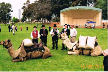
Photograph - PETER ELLIS COLLECTION: SWAN HILL BURKE AND WILLS 150TH CELEBRATIONS, 12th September, 2010
Colour photograph. Men standing behind 2 sitting camels. Date stamped 12/09/2010. Back of photo reads: Swan Hill Burke and Wills 150th Celebrations Gay Charmers & Emu Creek (Peter) charm the camels. Peter Ellis, Maurie Giesich (?), Ron McFarlane, Stuart Simmsand 'Afghan' handler.entertainment, music, musicians -
 Kew Historical Society Inc
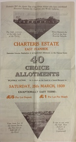
Plan - Subdivision Plan, Charteris Estate, East Ivanhoe, 1939
The Charteris Estate in Ivanhoe was sold in a number of sections. Copies of a subdivision plan of the first section is in the State Library of Victoria collection. This later section of the Charteris Estate includes lots in the Government Boulevard, Castella Street, McArthur Road, Burke Road North, Charteris Drive and Warncliff Road.Subdivision plans like that for the Charteris Estate are invaluable records for local historians identifying when lots in streets were promoted for sale.Four-fold brochure advertising the Charteris Estate in East Ivanhoe in 1939. Streets named on the plan include: the Government Boulevard, Castella Street, McArthur Road, Burke Road North, Charteris Drive and Warncliff Road. The brochure contains photos of Charterisville, the home of F De Castella Esq and also of attractive rolling hills. Annotations in pencilcharteris estate - east ivanhoe (vic), subdivision plans - east ivanhoe (vic) -
 Kew Historical Society Inc
Plan - Subdivision Plan, Charteris Estate, East Ivanhoe, 1939
The Charteris Estate in Ivanhoe was sold in a number of sections. Copies of a subdivision plan of the first section is in the State Library of Victoria collection. This later section of the Charteris Estate includes lots in the Government Boulevard, Castella Street, McArthur Road, Burke Road North, Charteris Drive and Warncliff Road.Subdivision plans like that for the Charteris Estate are invaluable records for local historians identifying when lots in streets were promoted for sale.Four-fold brochure advertising the Charteris Estate in East Ivanhoe in 1939. Streets named on the plan include: the Government Boulevard, Castella Street, McArthur Road, Burke Road North, Charteris Drive and Warncliff Road. The brochure contains photos of Charterisville, the home of F De Castella Esq and also of attractive rolling hills. Annotations in pencilcharteris estate - east ivanhoe (vic), subdivision plans - east ivanhoe (vic) -
 Kilmore Historical Society
Photograph, Sydney Street & Clarke Street
15cm x 10cm coloured photograph of the construction site on the corner of Sydney Street and Clarke Street. The site is now Coles Supermarket, Aldi, Liquorland, McDonalds, Coles Express, Kilmore Pizza Factory. Multiple photos taken over a period of time before the structure was being built. Brewery Hill can be seen in the backgroundWritten on the back: Site being prepared for the new Coles buildingconstruction, supermarkets -
 National Vietnam Veterans Museum (NVVM)
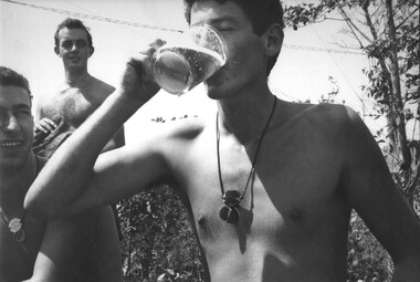
Photograph, Gibbons, Denis, 21st Birthday
Denis Gibbons (1937 – 2011) Trained with the Australian Army, before travelling to Vietnam in January 1966, Denis stayed with the 1st Australian Task Force in Nui Dat working as a photographer. For almost five years Gibbons toured with nine Australian infantry battalions, posting compelling war images from within many combat zones before being flown out in late November 1970 after sustaining injuries. The images held within the National Vietnam Veterans Museum make up the Gibbons Collection. A black and white photograph of 131st Divisional Locating Battery, 1st Field Regt RAA, off duty Gnr Ben Lombardo downs his pint mug of ale on his 21st birthday. The celebration was held, in the battery location on top if Nud Dat Hill, 1ATF Base, Phuoc Tuy Province, South Vietnam.photograph, 131st locating battery, 1st field regt, raa, gnr ben lombardo, nui dat, gibbons collection catalogue, birthday, 1 atf base, nui dat hill, phuoc tuy province, 21st birthday, denis gibbons -
 National Vietnam Veterans Museum (NVVM)
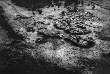
Photograph, Gibbons, Denis, Nui Thai Van Hills FSB
Denis Gibbons (1937 – 2011) Trained with the Australian Army, before travelling to Vietnam in January 1966, Denis stayed with the 1st Australian Task Force in Nui Dat working as a photographer. For almost five years Gibbons toured with nine Australian infantry battalions, posting compelling war images from within many combat zones before being flown out in late November 1970 after sustaining injuries. The images held within the National Vietnam Veterans Museum make up the Gibbons Collection. A black and white photograph of an oblique aerial view of an Australian Fire Support Base at the base of the Nui Thai Van Hills. The FSB provided a battalions direct artillery and mortar support, when on operation away from 1st Australian Task Force Base at Nui Dat, Phuoc Tuy Province. (circa May 1969)photograph, fire support base, 1st atf base, nui thai van hills, gibbons collection catalogue, artillery, mortar, nui dat, phuoc tuy province, denis gibbons -
 Glenelg Shire Council Cultural Collection
Painting, Robert Miller et al, Old Church Portland, 1965
CEMA Art CollectionThe painting depicts a church in an otherwise empty landscape. Within the foreground is a sweeping corner of a dirt road. Along the edge of the road runs a simple fence. Behind the church is a bare yellow and brown hill which reaches into a dark sky. The work has a wooden, white painted frame with grey mount and white trimming and glass.Front: Robert T. Miller 75 (lower right, black signature) Back: ROBERT MILLER " OLD CHURCH PORTLAND" (1966) (lower right, typed) Watercolourportland, church, streetscape, religion -
 Lakes Entrance Historical Society
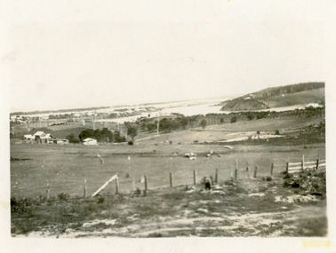
Photograph - Butcher's Paddock, Hanlon, Vera, 1940c
Historic home at 90 Captenter St 'Corrumbene' is pictured on right hand side of photograph. Godsell's house opposite on Western side of North ArmBlack and white photograph showing view of lower reaches of North Arm, part of town, Cunninghame Arm and sand dunes in background, and North Arm on right. Photo taken from Allens Hill, Myer St, vacant paddocks in foreground, known as Butcher's Paddock, slaughterhouse and buildings in mid view. Lakes Entrance Victoriatownship, waterways, animals -
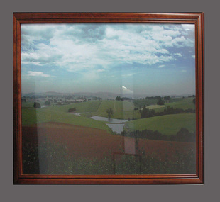 South Gippsland Shire Council
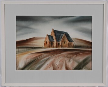
Photograph
Framed colour photograph featuring a landscape showing low hills, ploughed paddock in foreground and dams in centre. Brown timber frame. Note: Item approved for deaccession August 2023. SGSC will now follow deaccession procedures as outlined in the Arts and Civic Memorabilia Collection Policy - https://www.southgippsland.vic.gov.au/downloads/file/2763/arts_and_artefacts_collection_policy_c69. -
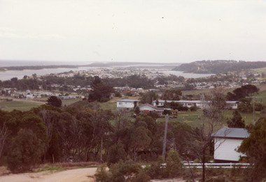 Lakes Entrance Historical Society
Photograph - Township
Colour photograph of township of Lakes Entrance showing North Arm, North Arm Bridge, Jemmys Point, Mount Barclay, Kalimna Heights, Cunningham Arm and sand dunes on left. Looking west to Bullock Island and Rigby Island. Photo taken from near Telecom Tower on Merrangbaur Hill. Lakes Entrance Victoria bridges, waterways, islands, township -
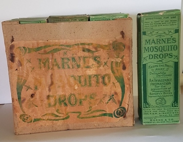 Linton and District Historical Society Inc
Mosquito drops, Marne & Co. Herbert St., Dulwich Hill, Sydney, N.S.W, Marne's Mosquito Drops, 1919
Found in the cellar of the former Barr's drapery shop, Sussex Street, Linton, which at one time had a doctor's consulting room. Bob Albert (who found them) assumed they were something to do with the medical practice. He gave the box of mosquito drops to Joan and Alan Giles. Information in newspaper advertising (found via Trove) shows the drops were marketed in New South Wales, Queensland and South Australia between about 1915 and 1927. The address on the packaging suggests these particular bottles were manufactured after 1918.Twelve green boxes labelled 'Marne's Mosquito Drops', stored in a strong cardboard box bearing a green label, also reading 'Marne's Mosquito Drops'. Information on individual cardboard packaging: "Marne & Co., Herbert St, Dulwich Hill, NSW / Registered under the Pure Food Act 1908 / Improved Formula 1919".marne's mosquito drops, pest control, mosquito drops -
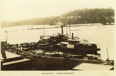 Lakes Entrance Historical Society
Photograph - New Works Jetty, 1910 c
Black and white photograph showing two steamers at New Works wharf, five or six other smaller vessels and crowds of people on wharf and steamers. Small shed on end of wharf, rooves of two buildings in foreground. Jemmys Point hill in the background and timber barrier wall for formation of Bullock Island. Lakes Entrance Victoria.The Wharf, Lakes Entranceships and shipping, waterways, jetties, people -
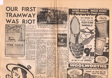 Melbourne Tram Museum
Newspaper, Herald Sun, "Our First Tramway was Riot", Jul. 1955
Newspaper clipping from The Herald, Monday 29 Dec. 1958, page 13 about the re-opening of the Box Hill - Doncaster tramway on 27/6/1891, the story of the tramway, involvement of Mr. Hilton, the Doncaster Tower, disputes with land owners, and its final closure on 6/1/1896. No author given for the article.trams, tramways, box hill, doncaster, tramways -
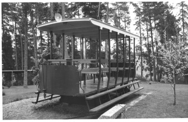 Melbourne Tram Museum
Photograph - Black and White photograph, Keith Kings, 11/10/1979 12:00:00 AM
Black and White photographs the replica open cross bench car of the Box Hill Doncaster - Doncaster tram. Made by the Doncaster-Templestowe City Council Workshops in 1979. Photographer notes that the rear that it was on display at the Doncaster Historical Society's restored Schramm's Cottage, Doncaster Dated 11/10/1979. Photo Number 179-34Has the Keith Kings photo stamp on the rear, with extensive details of the photograph.trams, tramways, box hill, doncaster, replica, cross bench tram -
 Bendigo Historical Society Inc.
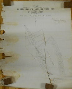
Document - MARKS COLLECTION: GROUND AND SURFACE WORKINGS BALLERSTEDT MINE VICTORIA HILL
Original plan in very poor condition, torn in centre (A copy is listed under No. 8300.36l). On top of plan 'Plan showing the position of the ground and surface workings in the claim of Mr. Ballerstedt Victoria Hill' Plan is signed by Thomas Forbes, Mining Surveyor, 22nd. April 1868. Plan shows house outline and open cut.bendigo, mining, ballerstedt mine victoria hill -
 Bendigo Historical Society Inc.
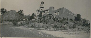
Photograph - CENTRAL NELL GWYNNE MINE
Black and white photograph of Central Nell Gwynne Mine on boundary of Ironbark. This was one of three gold mines marked for assistance to commence the mining revival. This steel poppet head previously stood over the Lightning Hill Mine and firstly over the Virginia Mine. Bendigonians can access the site from Coath Street. Inscriptions: On back - 'MNG 53', 'Nell Gwynne' in lead pencil, 'Central Nell Gwynne' in black ink', 'Royal Historical society of Victoria, Bendigo Branch' circular blue stamp. History of object: previous Acc. No. MNG 53central nell gwynne gold mine, gold mining -
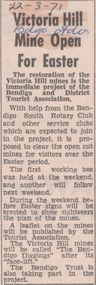 Bendigo Historical Society Inc.
Newspaper - VICTORIA HILL - VICTORIA HILL MINE OPEN FOR EASTER
Newspaper article from the Bendigo Advertiser dated 22/3/71. Article mentions the restoration of the Victoria Hill area with working bees by the Bendigo and District Tourist Association, the Bendigo South Rotary Club and the Bendigo Trust. It was proposed to clear the open cut mines for visitors over the Easter period. It will be called 'The Bendigo Diggings'.newspaper, bendigo advertiser, victoria hill, victoria hill mine open for easter, bendigo and district tourist association, bendigo south rotary club, tourist association, the bendigo diggings, the bendigo trust -
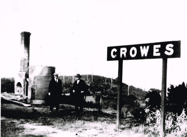 Otway Districts Historical Society
Photograph, Brucker, Crowes after the 1919 fires, 1919
The 1919 bushfire was the worst the area suffered. The fire struck on Saturday afternoon on the 15th February. It destroyed the station at Lavers Hill and Crowes, departmental residences at Lavers Hill and Weeaproinah, the overhead bridges at Beech Forest and Wimba, and damaged the track at various points along the line so that two locomotives became temporarily marooned at Beech Forest.. By the following Tuesday a daily fire relief train had begun operation. By the following Sunday a special train loaded with army tents travelled through to Lavers Hill and deposited most of its consignment there because little remained of this sizeable settlement. An outsider would have had difficulty in picking the place. The letters of the Lavers Hill station nameboard had been burnt although the metal letters survived, and one of the local wags had rearranged them to read "LIARS HELL". By the 1920s water trains were being used to help fight fires, a simple NQR open wagon loaded with the standard 1500 litre square iron water tank.B/W. Crowes station sign, the remains of a chimney, galvanised iron sheet and a water tank, and two men gazing at the camera. Note in the background the clear felling of the timber.crowes; lavers hill; beech forest; weeaproinah; wimba; railways; bushfire; -
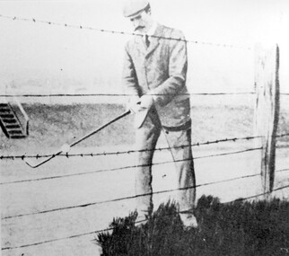 Surrey Hills Historical Society Collection
Photograph, Harry Culliton at Surrey Hills Golf Club
Reproduced by permission of Mr John Arnold from his book: "The Riversdale Golf Club - a history, 1892-1977." Copyright to book: Riversdale Golf Club. Surrey Hills Golf Club operated from 1892-1908 then moved and became Riversdale Golf Club. The game was played across paddocks from Trafalgar Street, Mont Albert to Whitehorse Road and down Victoria Crescent to where Box Hill TAFE is now located in Elgar Road. There were problems with cows eating the tee flags! The clubhouse still exists as 30 Trafalgar Street. The Surrey Hills Golf Club was founded by Mr Hugh W McLeod in 1894. The first president was Mr A W Harston. Mr William Meader was the first honorary secretary and the club champion for several years. Another notable identity was Mr. Harry Culliton, who contributed golf notes to "The Argus" for many years. Harry Culliton (clerk; later bank manager) married Christina Mary Rothwell of Surrey Hills in 1897. They initially live in Canterbury Road before moving to 'Bayview' in Harding Street. They had 3 sons. The eldest Kenneth Rothwell Culliton married Molly Fanny Arthur in 1940. They continued to live in 'Bayview'. Molly was a foundation member of the Surrey Hills Historical Society.The image is significant in documenting the Surrey Hills Golf Club, no longer in existence, but also members of early Surrey Hills families. Black and white photo showing a barbed wire and post fence behind which stands a man, identified as Harry Culliton. He is wearing a suit, cap and a tie. He sports a large 'handle-bar' moustache and is gripping an iron golf club, preparing to strike a golf ball which is impaled on the barbed wire.Caption: "Harry Culliton playing from the barbed wire where his ball was impaled on the fence on the side of the coffin. To his opponent's dismay he managed to land the ball near the green and get down in two for a half."sports grounds, surrey hills golf club, riversdale golf club, clothing and dress, john arnold, harry culliton -
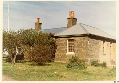 Flagstaff Hill Maritime Museum and Village
Photograph - Historical, Flagstaff Hill, The Lighthouse Keeper’s Cottage showing re-roofing carried out by Council, 1970s
The coloured photograph shows the Lighthouse Keepers' Quarters at Flagstaff Hill, Warrnambool. The building was erected in the 1850s on Middle Island, Lady Bay. It was relocated to its current location in the late 1870s along with the two lighthouses, the chart room and the privy. The Warrnambool City Council replaced the iron roof on the cottage in the 1970s and further work has since been carried out. The picture shows the poor condition of the stonework on the right hand side of the cottage. After the cottage ceased to be used by lighthouse keepers, it was rented out by various organisations and later became disused. The Historical Society requested the re-connection of power. The right hand side of the cottage was repurposed for use by Flagstaff Hill Maritime Museum and Village. in the 2020s it was restored and fitted out as the Alexander Farncombe room, which is used for temporary exhibitions. This photograph, a print, is one of a set of five that show the site of Flagstaff Hill. It is presumed to have been taken by John Lindsay, Founding Director of Flagstaff Hill Maritime Museum and Village. One of the photographs in the set has the pencil inscription "Photo J Lindsay". It was taken in the early 1970s during the initial stages of the development of Flagstaff Hill as a Museum and Maritime Village. The photographs belonged to the donor's grandparents, who lived in the Warrnambool district of Allansford/Naringal. The photograph is a record of the Lighthouse Keepers' Quarters at Flagstaff Hill Maritime Museum and Village before its development and opening in 1975. It shows the condition of the building at the time and some of the recent re-roofing. The photograph is significant for recording the condition of the original heritage listed building at that point in time.Coloured photograph, glassy print, one of a set of five. Photograph shows the Lighthouse Keepers' Quarters, focused on the Assistant's Quarters on the right. It shows the a new iron roof that had been installed by the Warrnambool City Council, and the condition of the bluestone,walls. There are clay chimney pots on the two chimneys. A set of steps are at the entry on the right hand side. The flagstaff is on the left of the photograph. The photograph's paper has the printer's watermark on the back. The early 1970s picture is presumed to have been photographed by John Lindsay, Warrnambool.Label on the back: "THE BLUESTONE COTTAGE SHOWING RE-ROOFING CARRIED OUT BY COUNCIL. The Historical Society has requested Council to have S.E.C. power re-connected"flagstaff hill maritime museum and village, warrnambool, maritime museum, shipwreck coast, 1970s, photograph, lady bay, flagstaff hill site, john lindsay, cannon emplacement, middle island, flagstaff, lighthouse keepers' quarters, lighthouse keepers' residence, alexander farncombe, re-roofing, s.e.c. connection