Showing 14729 items
matching south street
-
 Eltham District Historical Society Inc
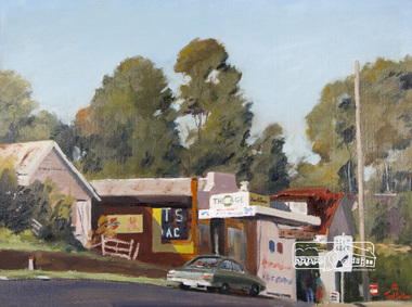
Photograph, Ted Dalton, The Corner Store, Ted Dalton, c.1980, 1980c
View of the old Burgoyne store looking south-east across Main Road, Eltham near the intersection with Bridge Street.Digital scan of painting c.1980 oil on board 44.5 x 59.5 cm signed lower rightburgoyne store, eltham, main road, ted dalton -
 Eltham District Historical Society Inc
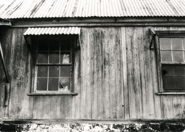
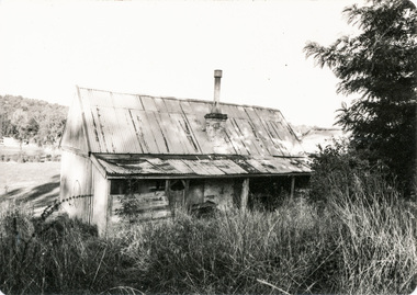
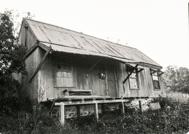
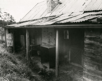
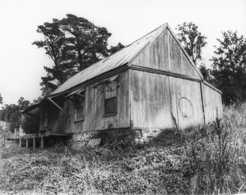
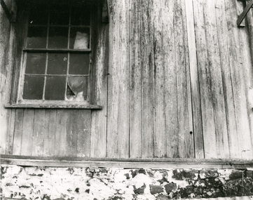
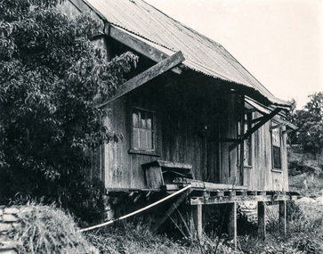
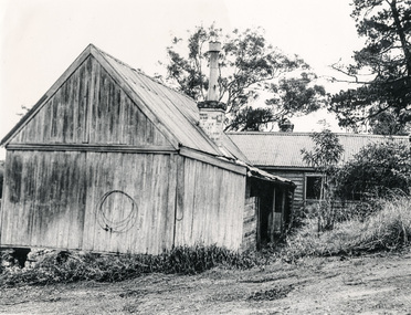
Photograph, Early settlers cottage, Ely Street, Eltham; May 1979, 1979
Falkiner Cottage, also known as Maynard's Cottage. Falkiner was the original owner and Maynard the last owner. This site was classified by the National Trust but there is no citation available. The Cottage has since been demolished. Located on the north side of Ely Street where present day #19 is situated. The cottage ran in a north-south orientation with an easterly aspect down the hill. Photographer: Alan Baker Refers File 550258 and 1903 7 photos 3.5x5 inches and 5 photos 8x10 inches.16 black and white photographsearly settlers, eltham, houses, cottage, ely street, falkiner cottage, maynard cottage -
 Eltham District Historical Society Inc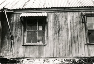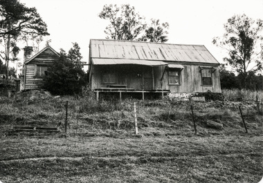
Photograph, Marjorie North, Montmorency Village Shopping Centre Looking south-southwest up from Railway Station up Were Street shops, Montmorency, 1986, 1986
Negatives supplied by Marjorie North 1 July 1986 for Montmorency France albumRoll of 35mm colour negative film, 3 stripsKodak CL 200 5093montmorency, were street, shopping centre -
 Eltham District Historical Society Inc
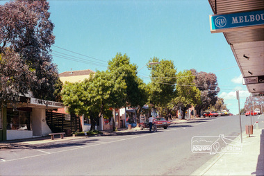
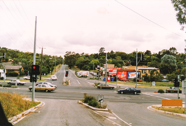
Photograph, Bolton Street, Eltham
... Five colour photographs of Bolton Street showing Eltham... Eltham South Shops and The Ridge complex. Bolton Street, Eltham ...Five colour photographs of Bolton Street showing Eltham South Shops and The Ridge complex.bolton street, eltham, montmorency, lower plenty, shops, factories, the ridge -
 Eltham District Historical Society Inc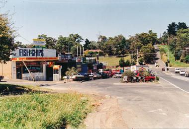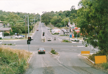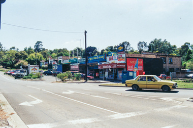
Photograph, Kangaroo Ground War Memorial, Eltham Heritage Tour, 24 May 1992, 24/05/1992
ELTHAM HERITAGE TOUR The Society excursion on 24th May 1992 was arranged by David Bick, leader of the team carrying out the Shire's heritage study. David selected a number of sites or buildings identified in the study, some of them lesser known components of the Shire's heritage. The tour commenced at the Eltham Shire Office at 10.00 am. Travel was by private car and mini-bus with stops at about twelve locations for commentary by David.It included a short walk in Hurstbridge and lunch at Kinglake. Highlights of the tour included: - 10 am Leave from Shire Offices - 3 Important Trees - A Physical Link to Eltham's First Settlers - Toorak Mansion Gates - A Surviving Farm House - An Intact Circa 1900 Main Street - First Settlers - Gold Miners, and Timber-getters - An Early Hotel - A Pioneering Homestead - Changing Eltham Shire - 20th Century - 4 pm Afternoon Tea and Finish Tour Extract from ELTHAM CULTURAL HERITAGE TOUR (Newsletter No. 85, July 1992, by Bettina Woodburn) "Now we drove through stands of pines to the Kangaroo Ground Lookout Tower, a most unusual War Memorial, World War I. The tower and a shed/residence (it had a chimney) were built from local sandstone. Below to the south and east of Melbourne spread 'suburbia'. Close by the landscape seemed so contrived - English fields and hedgerows! Although only about twenty inches deep, the soil of this ancient volcano, its crater lost under subsequent weathering, was rich, deserving the name of "Garden Hill". Now native trees are taking over again. In Kangaroo Ground itself stand the inevitable Store, School and Church - and two Norfolk pines and a monkey puzzle tree."Record of the Society's history and activities and highlighting various aspects of the Heritage Study undertaken by David Bick used to create the future heritage overlay for the Shire of Eltham and later Nillumbik Shire.Roll of 35mm colour negative film, 4 stripsKodak Gold 100 5095shire of eltham historical society, activities, heritage tour, kangaroo ground, kangaroo ground tower, war memorials, kangaroo ground memorial -
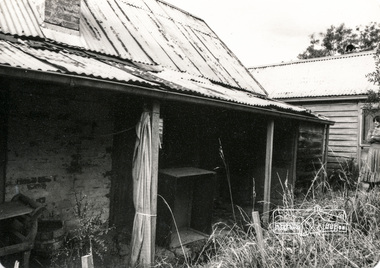 Eltham District Historical Society Inc
Photograph, Early settler's cottage, Ely Street, Eltham; May 1979, 1979
Falkiner Cottage, also known as Maynard's Cottage. Falkiner was the original owner and Maynard the last owner. This site was classified by the National Trust but there is no citation available. The Cottage has since been demolished. Located on the north side of Ely Street where present day #19 is situated. The cottage ran in a north-south orientation with an easterly aspect down the hill. Photographer: Alan Baker Refers File 550258 and 1903 7 photos 3.5x5 inches and 5 photos 8x10 inches. Twelve black and white photographsearly settlers, eltham, houses, cottage, ely street, falkiner cottage, maynard cottage -
 Eltham District Historical Society Inc
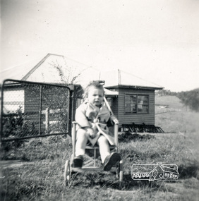
Photograph, View across 36 Beattie Street, Montmorency built by Stan Rushbrook looking south east. John Landy approx 1 year old, c.1952, 1952c
Digital copy of black and white photograph38 beattie street, montmorency, john landy, stan rushbrook -
 Eltham District Historical Society Inc
Photograph, Liz Pidgeon, Heritage Excursion; East of Eltham, 6 Sep 2014, 20 May 2017
Newsletter No. 218, September 2014 September Excursion - East of Eltham Walk In Newsletter No. 197, March 2011, there was a brief history of Crown Allotment 15 Section 5 Parish of Nillumbik (CA 15) a parcel of land of a quarter of a square mile extending from Eucalyptus Road to Reynolds Road at the eastern extremity of Eltham. From the 1940s it was known as Stokes orchard. In later years it has been subdivided for residential purposes but leaving significant areas as power line and water supply reserves and bushland reserves that are habitat for the threatened For our excursion on 6th September we intend to walk through CA 15 to a bushland reserve east of Reynolds Road. The walk will traverse the boundary between suburban Eltham and the non-urban areas to the south and east. This is a pleasant walk through residential areas and bushland. Along the way we will discuss the early and more recent history of CA 15 as well as local natural history and geology. This walk is about 3.5 km in length and will take 2 to 2.5 hours. It will start at 2pm at the corner of Eucalyptus Road, Pitt Street and Nyora Road.Born Digitaleltham east, eltham district historical society, heritage excursion, activities, nyora road, reynolds road, gum tree road reserve, diosma road, stokes orchard, eucalyptus road -
 Eltham District Historical Society Inc
Photograph, Liz Pidgeon, Heritage Excursion; East of Eltham, 6 Sep 2014, 20 May 2017
Newsletter No. 218, September 2014 September Excursion - East of Eltham Walk In Newsletter No. 197, March 2011, there was a brief history of Crown Allotment 15 Section 5 Parish of Nillumbik (CA 15) a parcel of land of a quarter of a square mile extending from Eucalyptus Road to Reynolds Road at the eastern extremity of Eltham. From the 1940s it was known as Stokes orchard. In later years it has been subdivided for residential purposes but leaving significant areas as power line and water supply reserves and bushland reserves that are habitat for the threatened For our excursion on 6th September we intend to walk through CA 15 to a bushland reserve east of Reynolds Road. The walk will traverse the boundary between suburban Eltham and the non-urban areas to the south and east. This is a pleasant walk through residential areas and bushland. Along the way we will discuss the early and more recent history of CA 15 as well as local natural history and geology. This walk is about 3.5 km in length and will take 2 to 2.5 hours. It will start at 2pm at the corner of Eucalyptus Road, Pitt Street and Nyora Road.Born Digitaleltham east, eltham district historical society, heritage excursion, activities, nyora road, reynolds road, gum tree road reserve, diosma road, stokes orchard, eucalyptus road