Showing 1947 items matching " burwood"
-
 Melbourne Tram Museum
Ephemera - Timetable, Melbourne & Metropolitan Tramways Board (MMTB), Three mixed timetables, Dec. 1968
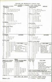
Timetable - printed or photocopied on foolscap paper for weekdays, Saturdays and Sunday and running times. Has various symbols for depot run in etc. In a style for public use. .1 - North Richmond - Prahran - St Kilda Beach - Feb. 1969 - two copies .2 - Wattle Park - City - Jan. 1969 - two copies .3 - Burwood - Spencer St - Dec. 1968trams, tramways, mmtb, timetables, buses, trams, north richmond, prahran, st kilda, wattle park, burwood -
 Melbourne Tram Museum
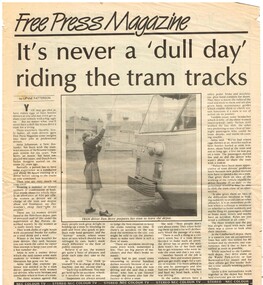
Newspaper, Free Press Camberwell, "Its never a 'dull day' riding the tram tracks.", 15/04/1986 12:00:00 AM
Newspaper clipping from the Free Press, 15/4/1986 titled "Its never a 'dull day' riding the tram tracks.", about three lady or women tram drivers at Camberwell depot and their experiences, including accidents, vandals, motor vehicle drivers, rules, Wattle Park and Burwood routes, and how they find their jobs. Interview Pam Berry, Anita Johanson, Helen Huygens for the article and has a reference to their supervisor, Ray Purves.trams, tramways, camberwell, burwood, wattle park, tram driving, women drivers, accidents, tram 143 -
 Camberwell Historical Society
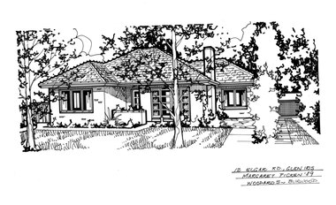
Drawing (series) - Architectural drawing, 12 Elgar Road, Glen Iris, 1989
artist, architectural drawings, margaret picken, camberwell, housesartist, architectural drawings, margaret picken, camberwell, houses -
 Ringwood and District Historical Society
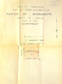
Document - Plan of Subdivision, Part of Crown Allotment 31B, Parish of Warrandyte, County of Evelyn - (undated, circa 1960s)
Map showing residential allotments numbered 1 and 2 on Through Road and Unsworth Road, Ringwood, Vic., with property dimensions and location of drainage & sewerage easement.H.J. Macey Licensed Surveyor, 36 Nerissa Street, Burwood (Telephone) BX1917. -
 Whitehorse Historical Society Inc.
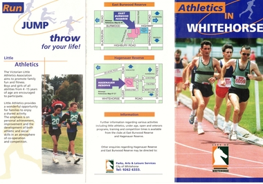
Pamphlet, Athletics in Whitehorse, ca 1998
Pamphlet about athletic facilitiesPamphlet about athletic facilities in the City of Whitehorse at East Burwood Reserve and Hagenauer Reserve, Box Hill.Pamphlet about athletic facilitiessportsgrounds, east burwood reserve, hagenauer reserve, box hill, athletics, city of whitehorse -
 Whitehorse Historical Society Inc.
Pamphlet, Community of the Sisters of the Church, c1990
Community of the Sisters of the Church - 100 years. New Provincial House and Novitiate in Mahoney's Road, East Burwood.community of the sisters of the church, religious orders -
Whitehorse Historical Society Inc.
Article, Group gets kiosk
Auxiliary members at the Peter James Centre, East Burwood, raise $30,000 and open a new kiosk. With photo.Auxiliary members at the Peter James Centre, East Burwood, raise $30,000 and open a new kiosk. With photo.Auxiliary members at the Peter James Centre, East Burwood, raise $30,000 and open a new kiosk. With photo.welfare services, peter james centre, kay, debbie, diamond, lylah, mahaffy, john, medical services, pearson, jo -
Whitehorse Historical Society Inc.
Article, Bikers jump at chance to test new track, 2005
Article on the new mountain bike circuit at East Burwood Reserve.Article on the new mountain bike circuit at East Burwood Reserve. With photo of 'Simon', 11, riding the track.Article on the new mountain bike circuit at East Burwood Reserve.east burwood reserve, cycling, bicycle paths -
Whitehorse Historical Society Inc.
Article, The Ensign Bearer, n.d
Foreword and first chapter of a book by Ossie Green on Robert Campbell Edwards, founder of the Burwood Boys Home.Foreword and first chapter of a book by Ossie Green on Robert Campbell Edwards, founder of the Burwood Boys Home.Foreword and first chapter of a book by Ossie Green on Robert Campbell Edwards, founder of the Burwood Boys Home.edwards, robert campbell, burwood boys home -
Whitehorse Historical Society Inc.
Document - Correspondence, Healesville Road, 1/09/1937
Claim for reimbursement from Country Roads Board for amounts expended on the Burwood Road by Shire of Blackburn and Mitcham.burwood road, roads and streets, shire of blackburn and mitcham, victoria. country roads board -
 Whitehorse Historical Society Inc.
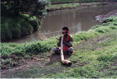
Photograph, Opening of Whitehorse Heritage Trail, 2/07/2001 12:00:00 AM
Heritage Trail funded by grant to the City of Whitehorse from Commonwealth of Australia to celebrate 100 years of Federation.Coloured photograph of an aborigine playing Didgeridoo at opening of Whitehorse Heritage Trail at Gardiners Creek Reserve, Burwood.whitehorse heritage trail, city of whitehorse, gardiners creek reserve, didgeridoo -
 Whitehorse Historical Society Inc.
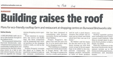
Article, Building Raises The Roof, 2018
The proponents of the Burwood Brickworks redevelopment have announced a sustainable rooftop farm and restaurant for the site's shopping centre.brickworks, burwood highway, burwood east, middleborough road, eley road, restaurants -
 Whitehorse Historical Society Inc.
Photograph - Colour Photograph, Tally Ho Business Park 2003
Tally Ho Business Park was developed by Land Lease, commencing in 1988, and then CGA Bryson from the late 1990's. It was completed in 2002. The land on which it stands was previously the site of the Tally Ho Boys Home. This home was run, from 1903-1986 by the Wesley Central Mission, which caters for boys from the slums. It closed in 1986.Coloured photograph of Tally Ho Business Park in the early stages, looking north towards Burwood Highway.tally ho, business park, 2003 -
 Whitehorse Historical Society Inc.
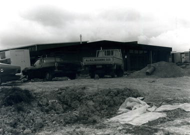
Photograph - B/W Photograph, Construction of Eley Park Community Centre 1978, 1978
Black and white photograph of the construction of the Eley Park Community Centre in Eley Road, Burwood East in 1978city of nunawading, eley park community centre, eley road, burwood east -
 Whitehorse Historical Society Inc.
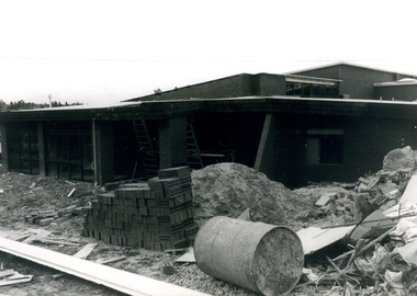
Photograph - B/W Photograph, Construction of Eley Park Community Centre
Black and white photograph of the construction of the Eley Park Community Centre in 1978, in Eley Road East Burwoodcity of nunawading, eley park community centre, eley road, burwood east -
 Whitehorse Historical Society Inc.
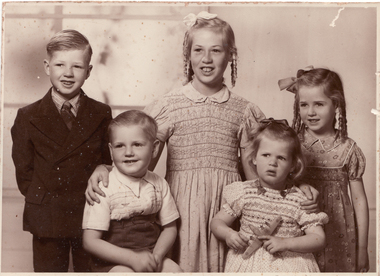
Photograph - B/W Photograph, Fankhauser family
Family of Mervyn and Florence Fankhauser of East Burwood. Back Ian, Margaret, Julie. Front Christopher, Leoniefankhauser ian, fankhauser family, fankhauser margaret, fankhauser julie, fankhauser christopher, fankhauser leonie -
 Melbourne Tram Museum
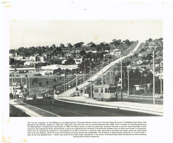
Photograph - Illustration/s, c1979
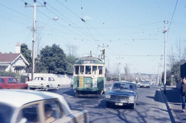
Illustration - black and white - possibly cut from a calendar sheet - of Burwood Highway, looking east just west of the Elgar Road intersection. Shows the relatively new track and Z25 inbound to Spencer St. Has a golden fleece service station on the left hand side. Shows the road arrangements at the time. Caption to illustration notes first new extension since 1956, opening date, reserved track and that Z class trams are used on it. One of the 1969 Metropolitan Transport Committee recommendations. Two copies held.trams, tramways, burwood highway, burwood, track construction, mmtb, z class, tram 25 -
Whitehorse Historical Society Inc.
Map, Aerial maps, 2/04/1966 12:00:00 AM
Melbourne 1966 project, runs 10A and 11A, lens 122 151.75 mm 9,800. Photo nos 77, 107, 109, 161, 163, 165.Melbourne 1966 project, runs 10A,11A and 12A, lens 122 151.75 mm 9,800. Photo nos 77, 107, 109, 161, 163, 165. Areas and boundaries: Map no 77 W. Park and Cook Roads; E. Dubon Rd; N Oban Rd; S Reilly St. Map No 107. W. Indra Rd and Pakenham St; E. Rooks Rd & McLares Rd; N. Maroondah Hwy; S. Hawthorn Rd & Eley Rd. Map No 109 W. Elgar Rd. E. Blackburn Rd & McKean St; S. Eley Rd & Burwood Hwy. Map No 161. W. Elgar Rd & Huntingdale Rd; E. Blackburn Rd; N. Burwood Hwy; S. Waverley Rd. Map No 163. W. Blackburn Rd; S. Springvale Rd; N. Eley Rd & Hawthorn Rd; S. Glen Waverley Railway Line. Map No 165. W. Stanley Rd, Vermont South; E. Cathies Lane, Wantirna South; N. North of Burwood Hwy; S. High Street. Melbourne 1966 project, runs 10A and 11A, lens 122 151.75 mm 9,800. Photo nos 77, 107, 109, 161, 163, 165. aerial photographs, blackburn, blackburn south, forest hill, nunawading, box hill, burwood, burwood east, donvale, mount waverley, glen waverley, wantirna, vermont south, mitcham, ringwood north, ringwood -
Whitehorse Historical Society Inc.
Article, Bid to get historic property
Progress Press article on the Box Hill City Council's offer to buy the old Burwood Primary School building at 166-172 Burwood Highway for $1 million from the Department of Education.Progress Press article on the Box Hill City Council's offer to buy the old Burwood Primary School building at 166-172 Burwood Highway for $1 million from the Department of Education. The school was built in 1865 and replaced an earlier school known as the Damper Creek Day School.Progress Press article on the Box Hill City Council's offer to buy the old Burwood Primary School building at 166-172 Burwood Highway for $1 million from the Department of Education. burwood primary school, no 461, city of box hill., victoria. education department, thorpe, tom, damper creek day school -
 Whitehorse Historical Society Inc.
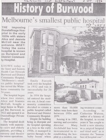
Article, Dunstaffnage Hospital, 02/10/1996
Photostat of an article from the Whitehorse Post Supplement 2 Oct 1996 about Dunstaffnage Hospitalnon-fictionPhotostat of an article from the Whitehorse Post Supplement 2 Oct 1996 about Dunstaffnage Hospitaldunstaffnage hospital, mccoll alice and jeannie, burwood and district community hospital -
 Melbourne Tram Museum
Photograph - Four color slides - tram W2 412 and tour ticket, 9-8-1970
Set of four colour slides taken during the Monash Railway club tour on 9-8-1970 using W2 412. The route number and destinations are for show only. Photography by Warren Doubleday. Ticket - No. 0004, printed on yellow card detailing the event. Date stamped on the rear using and Edmondson ticket dater.Yields information on Monash Railway club tour, the trams used, the ticket and the locations.Set of four Anscochrome colour slides, of Melbourne tram W2 412 on a Monash Railway Club tour - 9-8-1970 .1 - Shuntiing at Leura Grove Crossover in Burke Road .2 - Shunting at the crossover in Riversdale Road, near Glenferrie Road .3 - at the Burwood terminus .4 - Outside 412 Toorak Road. Since changed to 1412 Toorak Road .5 - Edmondson style ticket for the tourHas photographers slide numbers on each slide.monash railway club, w2 class, tram 412, toorak road, burwood, burke road, riversdale road, trams, tramways, tickets, edmondson tickets -
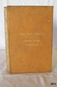 Flagstaff Hill Maritime Museum and Village
Book, Suns True Bearing or Azimuth Tables
Suns True Bearing or Azimuth Tables by John Burwood Publisher His Majestys Stationery Office Date 1898 flagstaff hill, warrnambool, shipwrecked-coast, flagstaff-hill, flagstaff-hill-maritime-museum, maritime-museum, shipwreck-coast, flagstaff-hill-maritime-village, suns true bearing or azimuth tables, azimuth tables, bearing, book -
Whitehorse Historical Society Inc.
Article, To live and work in a war zone, 2004
Rodney Cocks of East Burwood, United Nations peace worker, nominated for Victorian Australian of the Year award, 2005Rodney Cocks of East Burwood, United Nations peace worker, nominated for Victorian Australian of the Year award, 2005Rodney Cocks of East Burwood, United Nations peace worker, nominated for Victorian Australian of the Year award, 2005cocks, rodney -
 Whitehorse Historical Society Inc.
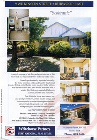
Document, 'Scobranic', 1/05/1998 12:00:00 AM
Land brochure giving details of the auction of 'Scobranic'Land brochure giving details of the auction of 'Scobranic' at 9 Wilkinson Street, East Burwood on 9/5/1998Land brochure giving details of the auction of 'Scobranic'land sales, 'scobranic', wilkinson street, burwood east no 9, whitehorse partners, shackleton, ted -
Whitehorse Historical Society Inc.
Article, Crops yield to city sprawl, 19/05/1999 12:00:00 AM
History of the Fulton family and its life in Burwood as market gardeners.History of the Fulton family and its life in Burwood as market gardeners until the encroachment of the suburbs led to the sale of the land.History of the Fulton family and its life in Burwood as market gardeners.market gardeners, fulton, jim, fulton, mary, fulton, charles, fulton, ann, fulton, nell, fulton, olive, fulton, bill, old burwood road, burwood east, no 89 -
Whitehorse Historical Society Inc.
Article, Students' art in exhibition
Forest Hill Secondary College - exhibition of VCE students graphic art at Burwood Heights senior campus. With photo.secondary schools, forest hill secondary college, forbes, cate, flint, bianca, kent, lauren, edwards, narelle, parrent, graeme -
Whitehorse Historical Society Inc.
Document, Land sales, n.d
Handwritten notes of land transactions 1855 - 1950, Crown Portion 109 bounded in part by Springvale and Burwood Roads.Handwritten notes of land transactions 1855 - 1950, Crown Portion 109 bounded in part by Springvale and Burwood Roads.Handwritten notes of land transactions 1855 - 1950, Crown Portion 109 bounded in part by Springvale and Burwood Roads.land subdivision, springvale road, vermont south, burwood highway, stanley road, mayne, alexander, james alexander, craig, mathew fergus, silas gordon, fankhauser, frederick william, clarence mervyn, mcnees, james, de leece, mackison, ferguson, samuel, mcgarrel, dennis, campbell, thomas, burrell, charles, meyer, jacob, huebner, otto, mihan, frederick, donaldson, john -
Whitehorse Historical Society Inc.
Article, Two million dollar scheme rejected by Council, 1974
A Proposed development of McLean's corner East Burwood was rejected in principle by City of Nunawading Council (Photo & sketch of proposal).A Proposed development of McLean's corner East Burwood was rejected in principle by City of Nunawading Council (Photo & sketch of proposal).A Proposed development of McLean's corner East Burwood was rejected in principle by City of Nunawading Council (Photo & sketch of proposal).webster, noel, mayors, city of nunawading, athan, savvas, councillors, taylor, frank, williams, w, oakley, gavan, mclean's corner east burwood -
Whitehorse Historical Society Inc.
Legal record - Land Title, Springvale Road, 1960
Aerial photograph of cnr. Springvale Road and Burwood Highway, south past Highbury Road and east to Vermont South.Aerial photograph of cnr. Springvale Road and Burwood Highway, south past Highbury Road and east to Vermont South.Aerial photograph of cnr. Springvale Road and Burwood Highway, south past Highbury Road and east to Vermont South.aerial photographs, springvale road, burwood east, burwood highway, burwood east, highbury road, burwood east, vermont south -
 Whitehorse Historical Society Inc.
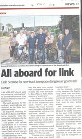
Article, Shared Path Link, 2018
A $4 million shared path will connect a 'missing link' on the side of Burwood HwyA $4 million shared path will connect a 'missing link' on the side of Burwood Hwy between Wantirna and Vermont South. A $4 million shared path will connect a 'missing link' on the side of Burwood Hwy bicycle paths, wantirna, vermont south, burwood highway