Showing 1406 items
matching bushfire
-
 Eltham District Historical Society Inc
Document - Folder, Mathews, Mary
Mary Mathews, aged 86, lived in Panton Hills for 80 years. She remembers her childhood and the 1914 and 1962 bushfires. Contents Newspaper article: "The world's her oyster, and at 86 she says 'safe home,' not 'goodbye'," Diamond Valley News, 24 June 1986, outlines Mary Mathews' life.Newspaper clippings, A4 photocopies, etcmary mathews, panton hill, jack mathews, panton hill primary school, bushfires -
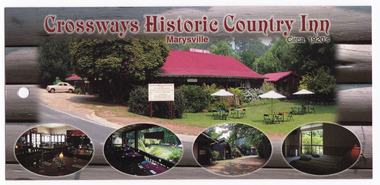
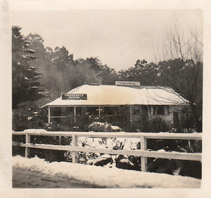
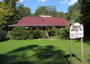 Marysville & District Historical Society
Photograph (Item) - Colour photograph, Unknown
A colour photograph of the Crossways Country Inn in Marysville. The Crossways was built in the early 1920s and is the oldest building in Marysville. The Crossways historic inn survived the 2009 Black Saturday bushfires thanks to the efforts of its c-owner Greg Cherry and, in the days after the fires, provided a much-needed refuge to the Marysville community and firefighters. A colour photograph of the Crossways Country Inn in Marysville.marysville, victoria, australia, photograph, the crossways cabaret, the crossways, crossways, crossways country inn, crossways historic inn, 2009 black saturday bushfires, accommodation -
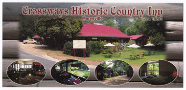
 Marysville & District Historical Society
Flyer (Item) - Information flyer, Crossways Accommodation, Unknown
An information flyer regarding The Crossways accommodation in Marysville. The Crossways was built in the early 1920s and is the oldest building in Marysville. The Crossways historic inn survived the 2009 Black Saturday bushfires thanks to the efforts of its co-owner Greg Cherry and, in the days after the fires, provided a much-needed refuge to the Marysville community and firefighters.An information flyer regarding The Crossways accommodation in Marysville.marysville, victoria, australia, the crossways cabaret, the crossways, crossways, crossways country inn, crossways historic inn, 2009 black saturday bushfires, accommodation, information flyer -
 Marysville & District Historical Society
Photograph (Item) - Colour photograph, Unknown
A digital copy of a colour photograph of The Crossways in Marysville. The Crossways was built in the early 1920s and is the oldest building in Marysville. The Crossways historic inn survived the 2009 Black Saturday bushfires thanks to the efforts of its co-owner Greg Cherry and, in the days after the fires, provided a much-needed refuge to the Marysville community and firefighters.A digital copy of a colour photograph of The Crossways in Marysville.marysville, victoria, australia, the crossways cabaret, the crossways, crossways, crossways country inn, crossways historic inn, 2009 black saturday bushfires, accommodation, crossways historic country inn, photograph -
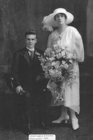 Marysville & District Historical Society
Photograph (Item) - Black and white photograph, 1923
A digital copy of a black and white photograph of Arthur and Grace Dickinson on their wedding day in 1923. Arthur built Marysville House in the late 1920s and they ran it as a guest house. Marysville House was the only guest house in Marysville to have survived the 2009 Black Saturday bushfires. It is now the private residence of Peter and Linda Dickinson.A digital copy of a black and white photograph of Arthur and Grace Dickinson on their wedding day in 1923. Arthur built Marysville House in the late 1920s and they ran it as a guest house.marysville, victoria, australia, marysville house, arthur james dickinson, grace dickinson, arnold spooner, eileen marie spooner, eileen marie dickinson, grace sweetland, eric dowdle, elsie may denton, elsie may dickinson, peter dickinson, linda dickinson, 2009 black saturday bushfires, photograph -
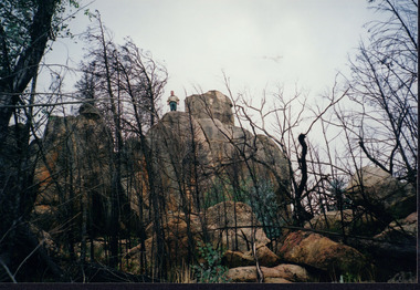 Wooragee Landcare Group
Photograph, circa April 2003
This photograph was taken in the Mount Pilot Chiltern National Park. This park is located near Chiltern in Victoria. It's most notable landmarks include Mt Pilot and Woolshed Falls. It also has many mines from the Gold Rush in the late 1800s. It is home to much flora and fauna, including the tiger quoll. The tiger quoll, also known as the spotted-tail quoll, is a marsupial that gives in the Mount Pilot Chiltern National Park. It is also main land Australia's largest carnivorous marsupial. It can weigh up too four kilograms and looks similar to either a possum or a spotted cat. It has red and brown fur with distinct spots. The tiger quoll is found along the Great Dividing Range, which includes Victoria, New South Wales and also near the border of Queensland. It lives in forests, rainforests and coastal heathlands and woodlands. In 2004 a team of volunteers from the Wooragee Landcare group as well as some of the Department of Sustainability and Environment staff set out to find the tiger quoll following the 2003 bushfires. Since the bushfires, concern had arisen for it because it hadn't been seen since the bushfires. They attempted to find traces of the quoll through finding and identifying their droppings as well as DNA testing. This photograph was taken during this search. This photograph represents the work that goes into protecting a important species like the tiger quoll. The tiger quoll is a significant species because it is main land Australia's largest carnivorous marsupial. As a result of this, there has been much work done to preserve and protect it. This photograph was taken when the Wooragee Landcare group went to ensure the survival of this species, highlighting how the tiger quoll is being protected. This photograph also demonstrates the impacts of the 2003 bushfires in the Mount Pilot Chiltern National Park. This is seen through the burnt trees featured in the picture. Landscape coloured photograph printed on gloss paperReverse: WAN NA 0ANA0N0 NNN 0 1636 / [PRINTED] (No.7) / 921quoll, mount pilot chiltern national park, national park, 2003 bushfires, search, endangered, beechworth, wooragee landcare group, wooragee landcare, wooragee, possum, australia, victoria, department of sustainability and environment, photograph, 2004, spotted-tailed quoll, great dividing range, spots, fur, forests, rainforests, woodlands, coastal heathlands, spotted quoll, spotted quoll habitat -
 Wooragee Landcare Group
Photograph
This photograph was taken in April 2004, on the field day in Mount Pilot-Chiltern National Park as part of a workshop on quolls, led by Andrew Murray, then president of the South East Forests Spot-Tailed Quoll Working Group. IThis event was prompted by a desire to find out if quolls still lived in Mount Pilot-Chiltern National Park, as there had been no confirmed sightings since the 2003 bushfires. Andy Murray helped lead the efforts to find them. Currently, landcare group efforts have found evidence of a small but present spot-tailed quoll population in the park. Reasons for the decrease in population include fox populations in the area and destruction of habitat. Pictured, L-R: unknown, Andy Murray, unknown, Jerry Alexander, Geoff Galbraith, Mary Prowse The spotted-tailed quoll, also called the Tiger Quoll, is an endangered Australian animal. It is the largest carnivorous mammal in Australia, and is native to Victoria, New South Wales, Queensland, and Tasmania. Slightly larger than a cat, the animals fur is normally brown, with black marking and white spots. Currently, there are approximately 14,000 spotted-tailed quolls in the wild.This photograph is significant as an example of events used by the Wooragee Landcare Group to inform the public on local environmental issues, and for its link to the hunt for the spotted-tailed quoll.Landscape colour photgraph printed on gloss paper. Reverse (partial) WAN quoll, south east forest spotted-tailed quoll working group, spotted-tailed quoll, tiger, mt pilot, andrew murray quolls, andy murray quolls, andrew murray, mount pilot chiltern national park, foxes, endangered quoll, queries about quolls, quoll species, wooragee, wooragee landcare, wooragee landcare group, jerry alexander, geoff galbraith, mary prowse, bushfire, chiltern -
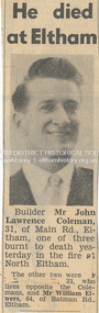 Eltham District Historical Society Inc
Newspaper - News Clipping, Herald, He died at Eltham. Herald, March 4, p3, 4 Mar 1965
John Lawrence Coleman (1934-1965) born January 10, was the son of Raymond John Coleman and Hanna May (Gillet) Coleman. He married Margaret Frances Dare in 1955 and was the father of two children. He died whilst attempting to rescue an older man trapped in the bushfire at North Eltham on March 3, 1965 He died at Eltham (Herald, 4 March 1965, p3) [Picture of John Lawrence Coleman] Builder Mr John Lawrence Coleman, 31, of Main Rd., Eltham, one of three men burnt to death yesterday in the fire at North Eltham. The other two were XXXXX, 33 who lives opposite the Colemans and Mr William Elwers, 64 of Batman Rd., Eltham. * * * Frank Martin was a volunteer with the Eltham rural fire brigade at the time of the 1965 bushfires which burnt Eltham North and Research. Frank was asked to assist with the removal of three bodies from the back gully (now Orchard Avenue). They were badly burnt and one was found stuck under a fence as though trying to escape. Volunteers John Coleman Jnr, William Elwers and George Crowe were killed trying to protect Eltham from bushfire – they were local heroes. At the time, John Coleman Jnr was survived by his wife Margaret and two young children – John 11 and Vicky 2. Margaret Coleman lived in the family home until 1992 when she sold it and moved to Tasmania to be close to her son. She died in 1997 aged 65 years. 75 yr old Ken Gaston grew up on Edendale farm, which was originally a poultry farm but is now owned and run by the Shire of Nillumbik as an educational farm for schools and visitors. He was Captain of the Eltham rural fire brigade in 1965 when John Coleman Jnr was burnt to death in the Eltham North bushfires serving as an unofficial volunteer. He was able to draw where the original Wattletree Road was and at the time was verified with the location of some remaining bitumen and a post from the original bridge over the Diamond Creek located near the junction of the Diamond Creek and another small creek which is further down from Research or Christmas Creek as locals refer to it. The original Main Road ran behind Colemans before the railway line was built beyond Eltham in 1912. (Information recorded by Harry Gilham, President EDHS c.2011) * * * Bushfires rage in Victoria, Snowy: Three dead (1965, March 4). The Canberra Times (ACT : 1926 - 1995), p. 1. Retrieved May 19, 2022, from http://nla.gov.au/nla.news-article131758981 Includes two photos of the fire in North Eltham “Firemen make for safety as fire rages in Upper Glen Park Road, North Eltham, Victoria. The smoke hides a house.” and “A house explodes into flames at North Eltham, Victoria. Firemen said bottled gas went up.” Canberra Times (ACT : 1926 - 1995), Thursday 4 March 1965, page 1 ________________________________________ Firemen make for safety as fire rages in Upper Glen Park Road. North Eltham. Victoria. The smoke hides a house. A house explodes into flames at North Eltham. Victoria. Firemen said bottled gas went up. Bushfires rage in Victoria, Snowy: Three dead MELBOURNE, Wednesday.—Three people died today in a bush» fire which raged through North Eltham, about 15 miles from Melbourne. The victims were three men. A fourth man is feared to be dead. Another bushfire. sparked off by the heatwave sizzling over south-eastern Australia, is burning out of control in the Kosciusko State Park, in the Snowy Mountains. Firefighters fear that if it reaches pine forests up the Yarrangobilly River, they will be powerless to stop it. The three victims of the North Eltbam fire were trapped by flames in a valley. Their bodies were found only a few yards apart. They were named by police tonight as Mr. George Crowe, 78, of North Eltham, William John Ewers, 64, and John Laurence Coleman, 31, both of Eltham. The other two have not been identified. They are believed to be a man aged about 40 and an 18-year-old youth. At least 12 homes were destroyed by the fire, the worst in Victoria since 1962, when eight lives were lost and hundreds of homes burnt down at Warrandyte. At one time the township of Eltham was threatened, but a cool change swept in from the south and held back the wall of flames. More than 100 dogs, worth about £4,000, died when the fire raced through two kennels in Short Street, Eltham. and Upper Glen Park Road, North Eltham. A trickle of water Residents ran into the streets as the blaze raced towards their houses. Others frantically dug firebreaks around their homes. Mrs. Sue Recourt wept when firemen arrived while she was vainly trying to stop the flames with a trickle of water from the garden hose. A stack of firewood was blazing, but the firemen managed to save the house and rescue four goats. Many homes in Eltham were saved after flames had crept to within feet of their fences. Students at North Eltham State School had to be evacuated when the blaze threatened the building. Fire fighters were severely hampered by lack of water and narrow roads. The blaze, which began in above century heat, turned toward Wattle Glen, where two houses were gutted. Then the flames raced towards Hurstbridge to the north. Firemen battling desperately, controlled the fire late this afternoon. Five forest fires were still burning in Victoria tonight. IN VICTORIA THIS WEEK Tragic lack of central fire authority (1965, March 9). The Canberra Times (ACT : 1926 - 1995), p. 2. Retrieved May 19, 2022, from http://nla.gov.au/nla.news-article131759928 Canberra Times (ACT : 1926 - 1995), Tuesday 9 March 1965, page 2 ________________________________________ IN VICTORIA THIS WEEK Tragic lack of central fire authority From Rohan Rivett It was the worst week for Victorian fire fighters since Black Friday 27 years ago. On that day one pilot up in a spotter plane said afterwards: "It seemed at times that half the State was on fire." This time, for three days on end, Gippsland men, women and children had moments of conviction that their towns would have blackened into anonymity before the weekend was out. The week began with horror at Eltham on the North-eastern edge of Melbourne. Eltham today is something of an artists' colony. Oil painters, water colourists, potters and sculptors proliferate. A number of University folk have emulated the example of Professor MacMahon Ball who pioneered the way by moving to Eltham and carving a home out of the bush in the thirties. Innermost Eltham is barely 14 miles from the G.P.O. Farthest Eltham stretches miles beyond. It served to illustrate the tragi-ludicrous truncation of Victoria's fire control. Part of Eltham is under the protection of the Melbourne Fire Brigade. But this responsibility ceases at some invisible and incomprehensible line — apparently determined by the meanderings of the water mains. At this point everybody's property throughout the rest of Eltham is dependent on the Country Fire Authority. Half an hour before midday on Wednesday, a fire suddenly started on the West side of Upper Glen road on the edge of Eltham. Before the fire brigade could arrive, it was burning on a widening front through timber and high grass north of Eltham. Two wind changes in rapid succession saw the fire leaping Diamond Creek. With a freshening wind it struck home after home in three streets. More than one of them exploded suddenly as if hit by an incendiary bomb. There is no piped gas in the Eltham area, hence many housewives use bottle gas. The flames outside caused the bottles to explode. Altogether twelve homes were completely incinerated and four more were badly damaged. Thirty prize dogs perished. About three hours after the fire started it raced suddenly down a gully hillside trapping an elderly man. Two other men apparently raced to the rescue. Flames caught the three men within yards of each other, not 200 yards off the Upper Glen Park Road where safety lay. They were burned to death. Next evening an angry and convincing secretary of the Fire Brigade Union, Mr. W. M. Webber, came on television and appealed to the people of Victoria to end the ridiculous and dangerous dualism in fire-fighting control. The Eltham fire, he said, had precisely illustrated the situation. The Metropolitan Fire Brigade area touched Eltham, but where the fire had gutted and killed, was just outside its area. Mr. Webber said his union had constantly urged one authority for the State with a complete reorganisation of fire protection. On Wednesday the union had repeated its call for an inquiry into fire protection in Victoria to the Chief Secretary, Mr Rylah. "No matter how close the liaison between the two organisations, there are always divided sections of thinking," Mr. Webber told viewers. "I don't know how much tragedy the com-munity can take before it demands that it is properly protected." Rumours that differences in gauge between taps and hose nozzles (as between the two authorities) accentuated the damage were denied by fire chiefs who said that all appliances were now carrying adaptors so that hoses could be linked to mains everywhere. But there is grave concern in the Metropolitan Fire Brigade's higher councils at the action of several Federal authorities with projects in and around Melbourne. They are installing non-standard equipment without reference to the State authorities or any dovetailing of appliances and equipment. Public alarm was not diminished by the publication on Friday and Saturday of a heart tearing letter from the young widow of John Lawrence Coleman, 31 year old father of two, who had died in the flames apparently trying to rescue the old man trapped in the gully. By that time, a Vast area of Gippsland was in flames and the troops had been sent in to back up the overworked and often helpless fire-fighters. By Saturday, the Leader of the Opposition, Mr. Stoneham, who has previously demanded a Royal Commission into fire-fighting arrangements, repeated his demand. To add to the Chief Secretary's worries he was publicly rebuked for allegedly implying on television that lives had been lost at Eltham because people went to the wrong place at the wrong time. In a letter to the Press, Professor MacMahon Ball pointed out that two of the men involved were experienced bushmen who had gone "to help an old man in great danger fully aware of the danger to themselves". As Victoria faced its sixth day of total State-wide fire ban, it looked likely that even official resistance was not going to silence the demand for one central authority to control the fire fiend. At the moment, the 400 square miles where two million Victorians live in Greater Melbourne are divorced from the rest of the State in planning, communications, equipment and control of personnel. No one doubts the whole-hearted co-operation and willingness to back each other up of the M.F.B. and the C.F.A., both at top-level and among the firemen themselves. However, when a city straggles so deeply into the country side, the absence of a single authority, to oversee and analyse the fire threat as a whole, suggests suicidal policy of divide and fuel. Emphasis of the tragic loss of a member of a pioneering family who died whilst helping others in his communitybushfire, cfa, country fire authority, fire brigrade, glen park road, heroes, john lawrence coleman, north eltham, victorian bushfires - 1965, volunteers, william john elwers, fire fighter, frank martin, george john crowe, ken gaston, orchard avenue -
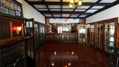
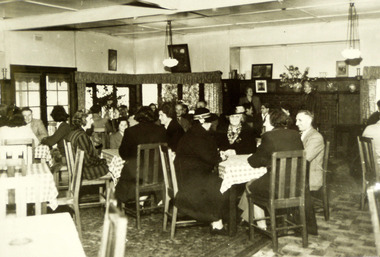 Marysville & District Historical Society
Photograph (Item) - Black and white photograph, Unknown
A black and white photograph of the dining area in The Crossways in Marysville. The Crossways was built in the early 1920s and is the oldest building in Marysville. The Crossways historic inn survived the 2009 Black Saturday bushfires thanks to the efforts of its c-owner Greg Cherry and, in the days after the fires, provided a much-needed refuge to the Marysville community and firefighters. A black and white photograph of the dining area in The Crossways in Marysville.marysville, victoria, australia, photograph, the crossways cabaret, the crossways, crossways, crossways country inn, crossways historic inn, 2009 black saturday bushfires, accommodation -
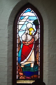 Greensborough Historical Society
Photograph - Digital image, Marilyn Smith, St Katherine's Church St Helena: Window 5, 29/05/2015
St Katherine's Church St Helena dates from 1858. The Church was built by Major Anthony Beale in memory of his wife Katherine Rose Beale. This photograph shows one of the stained glass windows; dedicated to those who restored this church. The Church had been damaged by a bushfire in 1957 and was rebuilt to the original plan.Digital copy of colour photographst katherines church st helena, anthony beale -
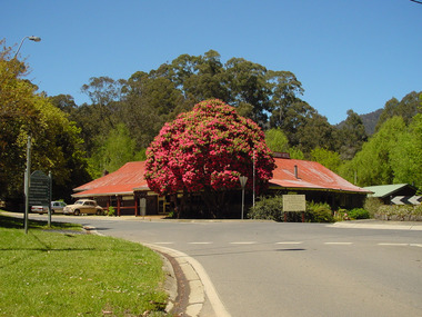
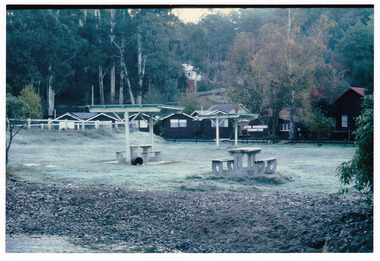 Marysville & District Historical Society
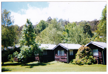
Photograph (Item) - Colour photograph, 1980s
A colour photograph of The Crossways Motel in Marysville taken in the 1980s. The Crossways was built in the early 1920s and is the oldest building in Marysville. The Crossways historic inn survived the 2009 Black Saturday bushfires thanks to the efforts of its c-owner Greg Cherry and, in the days after the fires, provided a much-needed refuge to the Marysville community and firefighters. A colour photograph of The Crossways Motel in Marysville taken in the 1980s.Crossways Motel/ one frosty morning in the 1980!/ approxmarysville, victoria, australia, the crossways cabaret, the crossways, crossways, crossways country inn, crossways historic inn, 2009 black saturday bushfires, accommodation, photograph -
 Marysville & District Historical Society
Photograph (Item) - Colour photograph, 1980s
A colour photograph taken at The Crossways Motel in Marysville in the 1980s. The Crossways was built in the early 1920s and is the oldest building in Marysville. The Crossways historic inn survived the 2009 Black Saturday bushfires thanks to the efforts of its co-owner Greg Cherry and, in the days after the fires, provided a much-needed refuge to the Marysville community and firefighters. A colour photograph taken at The Crossways Motel in Marysville in the 1980s.Crossways Motelmarysville, victoria, australia, the crossways cabaret, the crossways, crossways, crossways country inn, crossways historic inn, 2009 black saturday bushfires, accommodation, photograph -
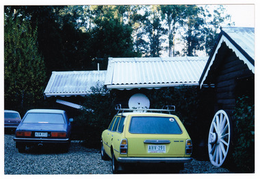
Marysville & District Historical Society
Document (Item) - Research document, Marysville & District Historical Society Inc, CROSSWAYS, Unknown
A document regarding the historic Crossways Inn in Marysville. The Crossways was built in the early 1920s and is the oldest building in Marysville. The Crossways historic inn survived the 2009 Black Saturday bushfires thanks to the efforts of its co-owner Greg Cherry and, in the days after the fires, provided a much needed refuge to the Marysville community and fire fighters.A document regarding the historic Crossways Inn in Marysville.marysville, victoria, australia, crossways historical inn, accommodation, 2009 black saturday bushfires -
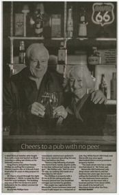 Marysville & District Historical Society
Newspaper (Item) - Newspaper article, Jay Town, Cheers to a pub with no peer, Unknown
A newspaper article regarding the selling of The Crossways Historic Inn in Marysville. The Crossways was built in the early 1920s and is the oldest building in Marysville. The Crossways historic inn survived the 2009 Black Saturday bushfires thanks to the efforts of its c-owner Greg Cherry and, in the days after the fires, provided a much-needed refuge to the Marysville community and firefighters. A newspaper article regarding the selling of The Crossways Historic Inn in Marysville.marysville, victoria, australia, the crossways cabaret, the crossways, crossways, crossways country inn, crossways historic inn, 2009 black saturday bushfires, accommodation, newspaper article -
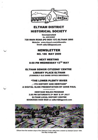 Eltham District Historical Society Inc
Newsletter, Newsletter, No. 186 May 2009
Contents: • Next meeting, Slide Presentation by Anne Paul; The Lower Plenty River; It’s history and heritage • May Meeting • May Heritage Walk • Black Saturday Bushfires • Black Friday 1851 • Eltham England Contacts • Office Bearers 2009-10 • Harry Gilham, Society President 1993-2009 • Subscriptions • Other News The Shire of Eltham Historical Society was formed in October 1967. The first newsletter of the Society was issued May 1978 and has been published continuously ever since on a bi-monthly basis. With the cessation of the Shire of Eltham in late 1994, the Society's name was revised to Eltham District Historical Society and this name first appeared with issue No. 103, July 1995. The collection of the Society's newsletters provides a valuable resource on the history of the Society's activities, office bearers and committee members, guest speakers and subjects of historical interest pertinent to the former Shire of Eltham and the Eltham District.A4 photocopied newsletter distributed to membersnewsletter, eltham district historical society, shire of eltham historical society -
 Ballarat Heritage Services
Photograph, Bellinzona House, 1900, 1900
Battista Borsa was from Bellinzona in Ticino, Switzerland. He named his house on the corner of Main road and Seventh St in Hepburn Springs "Bellinzona". His daughters ran the house as a guest house in 1900. This house was burnt down in the 1906 Bushfire. it was rebuilt in Edwardian tradition, and was again burnt down and rebuilt on a much larger footprint. A weatherboard house in the Main Road of Hepburn Springs, run by the Misses Borsa. borsa, bellinzona, boarding house, hepburn springs -
 Marysville & District Historical Society
Photograph (Item) - Colour photograph, 22-12-2001
A colour photograph taken at The Crossways in Marysville on 22nd December, 2001. The Crossways was built in the early 1920s and is the oldest building in Marysville. The Crossways historic inn survived the 2009 Black Saturday bushfires thanks to the efforts of its co-owner Greg Cherry and, in the days after the fires, provided a much-needed refuge to the Marysville community and firefighters. A colour photograph taken at The Crossways in Marysville on 22nd December, 2001.No.6./ OUR CABIN - CROSSWAYS/ 22 - 12 - 2001marysville, victoria, australia, the crossways cabaret, the crossways, crossways, crossways country inn, crossways historic inn, 2009 black saturday bushfires, accommodation, photograph -
 Marysville & District Historical Society
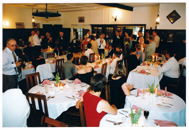
Photograph (Item) - Colour photograph, 03-1999
A colour photograph of the interior of The Crossways in Marysville during a wedding in March 1999. The Crossways was built in the early 1920s and is the oldest building in Marysville. The Crossways historic inn survived the 2009 Black Saturday bushfires thanks to the efforts of its co-owner Greg Cherry and, in the days after the fires, provided a much-needed refuge to the Marysville community and firefighters.A colour photograph of the interior of The Crossways in Marysville during a wedding in March 1999.wedding at Crossways/ March 1999/ Geoff & Sharyn Dimechmarysville, victoria, australia, the crossways cabaret, the crossways, crossways, crossways country inn, crossways historic inn, 2009 black saturday bushfires, accommodation, photograph -
 Marysville & District Historical Society
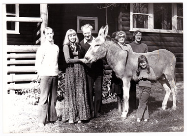
Photograph (Item) - Black and white photograph, Unknown
A black and white photograph of the Lingard Family of Marysville's "Crossways" restaurant. The Crossways was built in the early 1920s and is the oldest building in Marysville. The Crossways historic inn survived the 2009 Black Saturday bushfires thanks to the efforts of its co-owner Greg Cherry and, in the days after the fires, provided a much-needed refuge to the Marysville community and firefighters.A black and white photograph of the Lingard Family of Marysville's "Crossways" restaurant.Part 2 of/ Series Photographer: Colleen Myer/ 185 Maroondah Highway/ Healesville. MINE HOSTS The Lingard Family/ of Marysville's "Crossways"/ restaurant From left: Colin Lawrey (Chef, partner/ and "one of the family", Elizabeth, James/ Jean and David Lingard - with/ "Casey" the donkey, and the Lingards'/ niece Kathy.marysville, victoria, australia, the crossways cabaret, the crossways, crossways, crossways country inn, crossways historic inn, 2009 black saturday bushfires, accommodation, photograph, lingard family, colin lawrey -
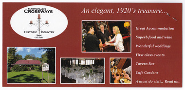
 Marysville & District Historical Society
Flyer (Item) - Information flyer, Graphic in Print, Crossways Historic Country Inn, Unknown
An information flyer regarding the Crossways Historic Country Inn in Marysville. The Crossways was built in the early 1920s and is the oldest building in Marysville. The Crossways historic inn survived the 2009 Black Saturday bushfires thanks to the efforts of its co-owner Greg Cherry and, in the days after the fires, provided a much-needed refuge to the Marysville community and firefighters.An information flyer regarding the Crossways Historic Country Inn in Marysville.marysville, victoria, australia, the crossways cabaret, the crossways, crossways, crossways country inn, crossways historic inn, 2009 black saturday bushfires, accommodation, information flyer, crossways historic country inn -
 Marysville & District Historical Society
Flyer (Item) - Information flyer, MARYSVILLE'S CROSSWAYS HISTORIC COUNTRY INN, Unknown
An information flyer regarding Crossways Historic Country Inn in Marysville. The Crossways was built in the early 1920s and is the oldest building in Marysville. The Crossways historic inn survived the 2009 Black Saturday bushfires thanks to the efforts of its co-owner Greg Cherry and, in the days after the fires, provided a much-needed refuge to the Marysville community and firefighters.An information flyer regarding Crossways Historic Country Inn in Marysville.marysville, victoria, australia, the crossways cabaret, the crossways, crossways, crossways country inn, crossways historic inn, 2009 black saturday bushfires, accommodation, information flyer, crossways historic country inn -
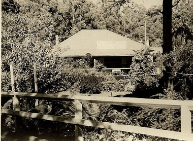 Marysville & District Historical Society
Photograph (Item) - Black and white photograph, 1948
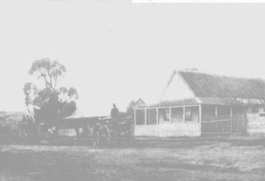
A digital copy of a black and white photograph of The Crossways in Marysville circa 1948. The Crossways was built in the early 1920s and is the oldest building in Marysville. The Crossways historic inn survived the 2009 Black Saturday bushfires thanks to the efforts of its co-owner Greg Cherry and, in the days after the fires, provided a much-needed refuge to the Marysville community and firefighters.A digital copy of a black and white photograph of The Crossways in Marysville circa 1948.marysville, victoria, australia, the crossways cabaret, the crossways, crossways, crossways country inn, crossways historic inn, 2009 black saturday bushfires, accommodation, crossways historic country inn, photograph -
 Marysville & District Historical Society
Photograph (Item) - Black and white photograph, Unknown
A digital copy of a black and white photograph taken of The Crossways Cabaret in Marysville. The Crossways was built in the early 1920s and is the oldest building in Marysville. The Crossways historic inn survived the 2009 Black Saturday bushfires thanks to the efforts of its co-owner Greg Cherry and, in the days after the fires, provided a much-needed refuge to the Marysville community and firefighters.A digital copy of a black and white photograph taken of The Crossways Cabaret in Marysville.marysville, victoria, australia, the crossways cabaret, the crossways, crossways, crossways country inn, crossways historic inn, 2009 black saturday bushfires, accommodation, crossways historic country inn, photograph -
 Marysville & District Historical Society
Photograph (Item) - Colour photograph, Unknown
A digital copy of a colour photograph taken in the interior of The Crossways in Marysville. The Crossways was built in the early 1920s and is the oldest building in Marysville. The Crossways historic inn survived the 2009 Black Saturday bushfires thanks to the efforts of its co-owner Greg Cherry and, in the days after the fires, provided a much-needed refuge to the Marysville community and firefighters.A digital copy of a colour photograph taken in the interior of The Crossways in Marysville.marysville, victoria, australia, the crossways cabaret, the crossways, crossways, crossways country inn, crossways historic inn, 2009 black saturday bushfires, accommodation, crossways historic country inn, photograph -
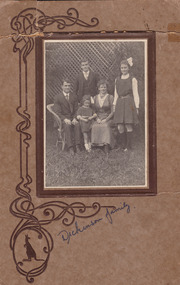 Marysville & District Historical Society
Photograph (Item) - Black and white photograph, P.F. Nash, 1917
A digital copy of a black and white photograph of the Dickinson Family taken in 1917. Arthur Dickinson built Marysville House in the late 1920s and ran it as a guest house along with his wife Grace. Marysville House was the only guest house in Marysville to have survived the 2009 Black Saturday bushfires. It is now the private residence of Peter and Linda Dickinson.A digital copy of a black and white photograph of the Dickinson Family taken in 1917.Dad Mum/ Arthur 19 yrs/ Eileen 17 yrs/ Elsie 4 yrs?/ 1917marysville, victoria, australia, marysville house, arthur james dickinson, grace dickinson, arnold spooner, eileen marie spooner, eileen marie dickinson, grace sweetland, eric dowdle, elsie may denton, elsie may dickinson, peter dickinson, linda dickinson, 2009 black saturday bushfires, photograph -
 Department of Energy, Environment and Climate Action
Vinten Forestphone
After the 1939 bushfires, the Forests Commission Victoria invested heavily in a radically new communications network. After suffering some inevitable delays due to the war, radio VL3AA switched into full operation in October 1945 proudly beaming out 200 watts across the State. But by today’s standards, the technology was primitive and the reception poor unless the user was on a high point somewhere. The radio signal was "line-of-sight" and bounced between fire towers and relay transmitters across the mountains back to the District offices. The advent of solid-state electronics in the 1960s replaced the more delicate valve sets which enabled greater use of vehicle mounted radios. The Commission continued to research, develop and build new radios at its many workshops around Victoria. The network was supported by a large team of skilled radio technicians. The more secure and versatile State Mobile Radio (SMR) digital trunk system came into operation in about 1995. Upgraded Tait Radios were purchased in 2014 after recommendations of the 2009 Bushfires Royal Commission. But it was the convergence of separate technologies such as 5G mobile phones, high-capacity and light-weight lithium batteries, Wi-Fi, the ever-expanding internet, cloud data storage, digital cameras, GPS, personal organisers and hundreds of supporting Apps into powerful smartphones and tablets which revolutionised bushfire communications from the mid-2000s.Vinten ForestphoneVL3ADforests commission victoria (fcv), communications -
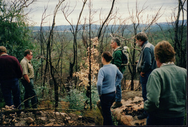
 Eltham District Historical Society Inc
Photograph, A walk through the cemetery at Kangaroo Ground, Diana Bassett-Smith, 1 October 2001, 2001
A huge warrior of a gum tree still stands sentinel at the wrought iron gates. In the distance some pencil pines. Survivors too of the disastrous bushfires which in the past have swept the district. A brief collection of reminiscences by Diana Bassett-Smith of locals who are buried at Kangaroo Ground Cemetery along with 17 photographs following a visit on 1 October 2001.Colour photograph print1983 bushfire, air vice marshall wackett, ambrose erswell, barry roach-pierson, bill pelling, billy roach-pierson, birrarung, bourchiers road, ca 13, crichton, david grant, diamond street, diana bassett-smith, donald grant, donaldson road, dorrie bourchier, duff, early settlers, elizabeth cottee, ewan cameron mp, grey house, helen kohn, isabella grant (nee stevenson), jack bourchier, james balfour, james wilson, jean stewart, jessie bull (nee haughton), jimmy cook, jocelyn, joseph stevenson, judge book village, judith furphy, kangaroo ground cemetery, kay roach-pierson, keith jocelyn, kraft foods, lacey, lloyd stuart, louise grant (nee gordon), mardi crocker, marion erswell, ned haughton, nursery, pam chevallier, passiona, peter bassett-smith, pigeon bank, rath, ricketson, robinson, ruth boyd, steven crawford baes, tintagell, tosch, vera jackson, wackett trainer, watershed jackson, willandra poultry farm, zac crocker -
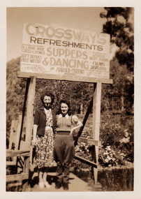 Marysville & District Historical Society
Photograph (Item) - Black and white photograph, 1948
A black and white photograph of two unknown ladies standing under the sign at The Crossways in Marysville. The Crossways was built in the early 1920s and is the oldest building in Marysville. The Crossways historic inn survived the 2009 Black Saturday bushfires thanks to the efforts of its c-owner Greg Cherry and, in the days after the fires, provided a much-needed refuge to the Marysville community and firefighters. A black and white photograph of two unknown ladies standing under the sign at The Crossways in Marysville.MARYSVILLE 1945marysville, victoria, australia, photograph, crossways, crossways cabaret, crossways historic inn, crossways country inn, accommodation, 2009 black saturday bushfires