Showing 2052 items
matching colour and design
-
 Eltham District Historical Society Inc
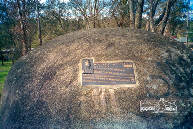
Photograph, Walter Withers Memorial Plaque, cnr Bible and Arthur Streets, Eltham designed by Joh Ebeli, c.October 1990, 1990
Roll of 35mm colour negative film, 4 stripsKodak GC400-8arthur street, bible street, walter withers, walter withers reserve, walter withers rock -
 Eltham District Historical Society Inc
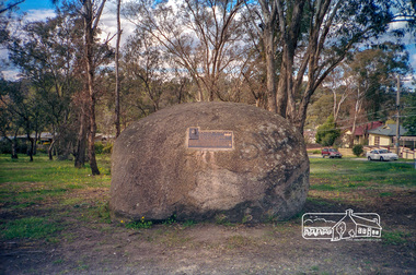
Photograph, Walter Withers Memorial Plaque, cnr Bible and Arthur Streets, Eltham designed by Joh Ebeli, c.October 1990, 1990
Roll of 35mm colour negative film, 4 stripsKodak GC400-8arthur street, bible street, walter withers, walter withers reserve, walter withers rock -
 Eltham District Historical Society Inc
Photograph, Doug Orford, Eltham Courthouse, 730 Main Road, Eltham, 1985, 1985
This building is a fine example of a very early small brick country court house which retains its furnishings and has important associations with the early history of the Eltham township. It was used for Eltham Road Board meetings in the 1860s and later to provide additional school accommodation. It is the oldest public building remaining in Eltham and forms an important group in historic and streetscape terms with the adjoining former police residence. The survival of the furnishings (of unknown origins) is of particular significance given the building's age. This building, and the former police residence beside it, were constructed as a result of a petition by five Eltham residents in 1857. The nearest police were at Heidelberg eight miles away or at the Caledonia Diggings 21 miles away. After the construction of the Court of Petty Sessions at Eltham in 1859-60 (which was designed by the Public Works Department and built by a Mr Duncan for a cost of 536 pounds), it was used for a variety of purposes. Eltham Road Board meetings were held there until 1868 when the board was transferred to Kangaroo Ground and as the Road Board Secretary's office, until this was transferred to Wingrove Cottage in 1867. It was used as an overflow for the Dalton Street School in 1875. According to National Trust records, the Eltham Court House is a relatively rare building type. There are only six other known examples of similar small brick country court houses in the state which have small projecting entry porches and a gabled form. Roll of 35mm colour negative film, 7 stripsFuji 100Neltham, eltham courthouse, main road -
 Eltham District Historical Society Inc
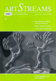
Journal, Peter Doughtery, ArtStreams: News in arts and cultural heritage; Vol. 3, No. 3, Jun-Jul 1998, 1998
Vol. 3, No. 3, Jun-Jul 1998 CONTENTS BANNERS MAKE A MARK Whittlesea lifts its arts profile 2 THE DROVER'S BOY A new play by Ray Mooney 3 HOME AWAY FROM HOME Nillumbik finally discovers a new tourist potential 5 OUT OF DESIGN, INTO ART A tour of Tony Clark's public and private paintings at Heide 7 BOOK REVIEW The Blue Gate, by Alison Groggon 11 THE ACCIDENTAL ARCHIVE The work of Jenni Mitchell 12 GOING IT ALONE David Moore make a critical decision 14 ENTERTAINMENT Pictorial round-up of local artists 16 A WAY WITH BOOKS Kay Sagar sets the scene in schools 18 SHORT STORY BY JON WEAVING 19 THEATRE WITH CAROLYN PICKETT 22 BOOK REVIEW - NICE TRY 25 CD REVIEW 26 PLEASURE IN ART Interview with Marian Sussex, aged 82 27 FRESH APPROACH TO SHAKESPEARE 29 ARTS SERVICES & TEACHING 30 WINING, DINING & ENTERTAINING 31 New looks in local parks 32 "Peter Dougherty has been involved in the local art scene for many years. As publisher and editor of the arts magazine Artstreams, his comments on the various branches of the arts are widely respected. His "The Arts" column in the Diamond Valley Leader presents a brief summary for a much wider cross section of the local community. Peter also operates his own gallery and the Artstreams Cafe at the St Andrews market. Peter has a wealth of knowledge about present day and historical aspects of local art and artists." - Eltham District Historical Society Newsletter No. 161, March 2005Colour front and back cover with feature articles and literary pieces with photographs and advertisements printed in black and white. 36 pages, 30 cm. Vol. 1, no. 1 (Nov. 1996) - Vol. 10, no. 5 (summer ed. 2005/06) art streams, were street cafe, sam alessi, plenty ranges arts and convention centre, ray mooney, dymocks booksellers, adams of north riding, bed and breakfasts, b&b, eltham garden retreat, tony clark, eltham library community gallery, alison croggan, ian mcbryde, ward sagar, jenni mitchell, emma lew, ken taylor, pietro ristorante grossi, david moore, dynamic vegies, yarra valley country club, tim mclean, petery haydon, mirth, volumes, cate bailey, songlines, jane mcgeogh-brittan, azure, margaret roadknight, mezze restaurant warrandyte, andre mcauley, robbie grieg, melanie shanahan, ricky ozimo, george dreyfus, sebastian jorgensen, angie mcmillan, kay sagar, jon weaving, heidelberg thearte company, carolyn pickett, llobex image wizards, shane moloney, michelle lonsdale, birrarung, anglea abbot, don james, john wakefield, la piazza restaurant bar & cafe, eltham high school, kavisha mazzello, robbie grieg, recherche speciality picture framing, marian sussex, maree wesols, anne maree graham, art in public places, albert tucker, museum of modern art at heide, montsalvat -
 Eltham District Historical Society Inc
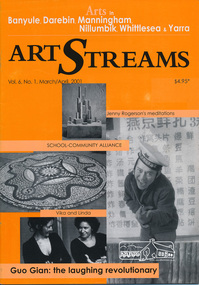
Journal, Peter Doughtery, ArtStreams: Arts in Banyule, Darebin, Manningham, Nillumbik, Whittlesea & Yarra; Vol. 6, No. 1, Mar-Apr 2001, 2001
Vol. 6, No. 1, Mar-Apr 2001 CONTENTS Vika & Linda Between Family and Fame 3 Eltham History in Ceramics A school Community cooperation 6 Exposing the beauty of clay International Pottery Market in Warrandyte 8 Were Street Hill Climb Banyule's Boutique Festival 11 Between Swirl and Solid Jenny Rodgerson's Meditations on lndeterminacy 12 Guo Gian and Anthony Pryor at HeideMOMA A laughing pointer and a craftsman sculptor 14 Dandenong Ranges Folk Festival The Hills Were Alive 16 Book Review Penelope Hobhouse's Flower & Garden Design 18 Theatre Review Kathy Oliver visits La Mama 19 Australian Classical Music Elizabeth Scarlett 20 New faces The Arts Administration Shuffle 22 Bolin Bolin Billabong Cultural Precinct and Walking Trail 24 CD Reviews 26 Artin About 28 Wining & Dining 30 Art Services and Teaching 32 "Peter Dougherty has been involved in the local art scene for many years. As publisher and editor of the arts magazine Artstreams, his comments on the various branches of the arts are widely respected. His "The Arts" column in the Diamond Valley Leader presents a brief summary for a much wider cross section of the local community. Peter also operates his own gallery and the Artstreams Cafe at the St Andrews market. Peter has a wealth of knowledge about present day and historical aspects of local art and artists." - Eltham District Historical Society Newsletter No. 161, March 2005Colour front and back cover with feature articles and literary pieces with photographs and advertisements printed in black and white. 36 pages, 30 cm. Vol. 1, no. 1 (Nov. 1996) - Vol. 10, no. 5 (summer ed. 2005/06) art streams, banyule festival, vika and linda, willy wonka's ice cream gourmet food, eltham high school, arts science courtyard project, plenty views golf park, jane annois, nillumbik festival of the arts, bahnhof cafe, dynamic vegies, were st food store, were street hill climb, walkers wheels, jenny rodgerson, claire renkin, heide museum of modern art, guo jian, anthony pryor, dandenong ranges folk festival, kinglake galley, bulleen art & garden, montsalvat, rachel hanrahan, fran silvester, helen baker, katrina phillips-rank, old bakery cottage, bolin bolin billabong, eltham wiregrass gallery, thompsons pharmacy, st andrews market, heide museum of modern art -
 Eltham District Historical Society Inc
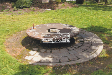
Slide - Photograph, Monument with time capsule, Eltham Community Centre, Main Road, Eltham, c.1997
The monument with time capsule was established by the Shire of Eltham Historical Society to commemorate Victoria’s 150th anniversary and mark the former location of the Eltham Town Centre, which existed along this section of Main Road, then known as Maria Street. The unveiling was conducted 10 November 1985 by Cr. Mary Grant (Shire President). The monument was constructed with a concrete base and the main feature is an old tyring plate or disc. The Time Capsule Ceremony involved lowering the sealed time capsule into place, bolting down its container lid and then concreting over the lid. The capsule contains items relating to present day (1985) Eltham and its people including a video film made by Joh Ebeli and also details of families and organizations who have contributed to construction of the monument. It is to be opened in the year 2035. The Society received an excellent response from local people, firms and organizations by way of assistance with this project. Graham Beyer, who originated the project, arranged many of the donations. He and his firm, Package Handling Equipment, donated the time capsule itself and carried out fabrication of sections of the monument. The design of the monument was adapted by Graham Beyer from drawings by Joh Ebeli. Charmac Industries donated the container for the time capsule and a cast gun metal name plate for the monument. BMG Concrete donated concrete for the base which was constructed by Caridi Construction Company. Northbourne Garden Supplies donated materials for the paving around the monument. Robert Becker from Eltham Apex directed construction of the paving by Society members. Terry Hutchinson donated the use of his crane to lift the tyring disc into place. Financial contributions were also made by the Eltham Chamber of Commerce and the Rotary Club of Eltham. In 1987 in commemoration of the Society’s 20th Anniversary, Joh Ebeli suggested the commissioning of a plaque to be added which explains the functions of the various items used in the Society’s Victorian 150th Anniversary Monument and this was unveiled by its designer, Joh Ebeli, on October 10, 1987. Circa 2010-2012 the monument was damaged through vandalism. The mounts for the ring had been broken. At the time of this photo the ring had been removed by Jim Connor, President of the Eltham District Historical Society and placed in safe storage whilst arrangements were made with Neil Carter of Carter Art, Research to undertake the repairs.Colour printeltham, eltham community centre, monument, public art, time capsule, carter art, neil carter -
 Eltham District Historical Society Inc
Opening of Meruka Childcare Co-operative, Meruka Park, 5 Meruka Dr, Eltham, April 1994
In 1919 J.B. North, a violinist with the then Melbourne Symphonic Orchestra, and Monsieur Leon Lambert, a French architect, who later designed the Glaciarium Ice Skating Rink, purchased three available farms, Looker's, Wright's and Taylor's, approximately 60 acres, the area running along the creek and being bordered by the present day Ryans Road, Karingal Drive and Sherbourne Road. The farms were used for orchards and market gardens. Leon Lambert designed and built two homes on the farm site, one for the North family, ‘Tralford’, and the other, ‘Glen Ellen’, for himself and his wife. The homes were considered as "brother and sister" and they each included in their design an identical bay window in the main living area. "Glen Ellen" originally comprised kitchen, lounge room, inglenook, dining room, bath room and sleepout. Although the home has been extended over the years, much of the original architecture has been retained including timber panelling and three fireplaces. The land was subdivided in approximately 1966 with "Glen Ellen" retaining approximately one half acre of land fronting Meruka Drive. The property then passed from the Charleston family to Gerald and Margaret Sutton in 1976 and again was sold in 1980 and lastly sold again in 1994. The Norths named their house 'Tralford'. According to Marjorie North, the name Meruka was suggested by Alan Gardner and so was apparently not used by the North family. The name appears to be of Indian origin and its connection with the land is not known. ‘Tralford’ stayed in the North family for many years. Eltham Council acquired the house to create Meruka Park. The house was used for some years by the Council as a community arts facility and as emergency accommodation. It fell into disrepair and was demolished about 1990. The Meruka Child Care Centre has been built on the site and incorporates some of the architectural features of the old house. The Co-op was opened in April 1994. The original drive flanked by large old cypress trees remains. These trees are considered to be of local heritage significance and for this reason Meruka Park is covered by a Heritage Overlay under the Nillumbik Planning Scheme. Part of the park has been preserved as habitat for rare local flora. LL's house, named ‘Glen Ellen’, remains in a well-preserved state and fronts Meruka Drive.cr pam sladden, eltham, meruka child care co-operative, meruka house, meruka park -
 Eltham District Historical Society Inc
Opening of Meruka Childcare Co-operative, Meruka Park, 5 Meruka Dr, Eltham, April 1994
In 1919 J.B. North, a violinist with the then Melbourne Symphonic Orchestra, and Monsieur Leon Lambert, a French architect, who later designed the Glaciarium Ice Skating Rink, purchased three available farms, Looker's, Wright's and Taylor's, approximately 60 acres, the area running along the creek and being bordered by the present day Ryans Road, Karingal Drive and Sherbourne Road. The farms were used for orchards and market gardens. Leon Lambert designed and built two homes on the farm site, one for the North family, ‘Tralford’, and the other, ‘Glen Ellen’, for himself and his wife. The homes were considered as "brother and sister" and they each included in their design an identical bay window in the main living area. "Glen Ellen" originally comprised kitchen, lounge room, inglenook, dining room, bath room and sleepout. Although the home has been extended over the years, much of the original architecture has been retained including timber panelling and three fireplaces. The land was subdivided in approximately 1966 with "Glen Ellen" retaining approximately one half acre of land fronting Meruka Drive. The property then passed from the Charleston family to Gerald and Margaret Sutton in 1976 and again was sold in 1980 and lastly sold again in 1994. The Norths named their house 'Tralford'. According to Marjorie North, the name Meruka was suggested by Alan Gardner and so was apparently not used by the North family. The name appears to be of Indian origin and its connection with the land is not known. ‘Tralford’ stayed in the North family for many years. Eltham Council acquired the house to create Meruka Park. The house was used for some years by the Council as a community arts facility and as emergency accommodation. It fell into disrepair and was demolished about 1990. The Meruka Child Care Centre has been built on the site and incorporates some of the architectural features of the old house. The Co-op was opened in April 1994. The original drive flanked by large old cypress trees remains. These trees are considered to be of local heritage significance and for this reason Meruka Park is covered by a Heritage Overlay under the Nillumbik Planning Scheme. Part of the park has been preserved as habitat for rare local flora. LL's house, named ‘Glen Ellen’, remains in a well-preserved state and fronts Meruka Drive.eltham, meruka child care co-operative, meruka house, meruka park, cr. peter graham, peter staples, richard allen, sheryl garbutt, bill penrose -
 Eltham District Historical Society Inc
Opening of Meruka Childcare Co-operative, Meruka Park, 5 Meruka Dr, Eltham, April 1994
In 1919 J.B. North, a violinist with the then Melbourne Symphonic Orchestra, and Monsieur Leon Lambert, a French architect, who later designed the Glaciarium Ice Skating Rink, purchased three available farms, Looker's, Wright's and Taylor's, approximately 60 acres, the area running along the creek and being bordered by the present day Ryans Road, Karingal Drive and Sherbourne Road. The farms were used for orchards and market gardens. Leon Lambert designed and built two homes on the farm site, one for the North family, ‘Tralford’, and the other, ‘Glen Ellen’, for himself and his wife. The homes were considered as "brother and sister" and they each included in their design an identical bay window in the main living area. "Glen Ellen" originally comprised kitchen, lounge room, inglenook, dining room, bath room and sleepout. Although the home has been extended over the years, much of the original architecture has been retained including timber panelling and three fireplaces. The land was subdivided in approximately 1966 with "Glen Ellen" retaining approximately one half acre of land fronting Meruka Drive. The property then passed from the Charleston family to Gerald and Margaret Sutton in 1976 and again was sold in 1980 and lastly sold again in 1994. The Norths named their house 'Tralford'. According to Marjorie North, the name Meruka was suggested by Alan Gardner and so was apparently not used by the North family. The name appears to be of Indian origin and its connection with the land is not known. ‘Tralford’ stayed in the North family for many years. Eltham Council acquired the house to create Meruka Park. The house was used for some years by the Council as a community arts facility and as emergency accommodation. It fell into disrepair and was demolished about 1990. The Meruka Child Care Centre has been built on the site and incorporates some of the architectural features of the old house. The Co-op was opened in April 1994. The original drive flanked by large old cypress trees remains. These trees are considered to be of local heritage significance and for this reason Meruka Park is covered by a Heritage Overlay under the Nillumbik Planning Scheme. Part of the park has been preserved as habitat for rare local flora. LL's house, named ‘Glen Ellen’, remains in a well-preserved state and fronts Meruka Drive.eltham, meruka child care co-operative, meruka house, meruka park, cr. john cohen -
 Eltham District Historical Society Inc
Opening of Meruka Childcare Co-operative, Meruka Park, 5 Meruka Dr, Eltham, April 1994
In 1919 J.B. North, a violinist with the then Melbourne Symphonic Orchestra, and Monsieur Leon Lambert, a French architect, who later designed the Glaciarium Ice Skating Rink, purchased three available farms, Looker's, Wright's and Taylor's, approximately 60 acres, the area running along the creek and being bordered by the present day Ryans Road, Karingal Drive and Sherbourne Road. The farms were used for orchards and market gardens. Leon Lambert designed and built two homes on the farm site, one for the North family, ‘Tralford’, and the other, ‘Glen Ellen’, for himself and his wife. The homes were considered as "brother and sister" and they each included in their design an identical bay window in the main living area. "Glen Ellen" originally comprised kitchen, lounge room, inglenook, dining room, bath room and sleepout. Although the home has been extended over the years, much of the original architecture has been retained including timber panelling and three fireplaces. The land was subdivided in approximately 1966 with "Glen Ellen" retaining approximately one half acre of land fronting Meruka Drive. The property then passed from the Charleston family to Gerald and Margaret Sutton in 1976 and again was sold in 1980 and lastly sold again in 1994. The Norths named their house 'Tralford'. According to Marjorie North, the name Meruka was suggested by Alan Gardner and so was apparently not used by the North family. The name appears to be of Indian origin and its connection with the land is not known. ‘Tralford’ stayed in the North family for many years. Eltham Council acquired the house to create Meruka Park. The house was used for some years by the Council as a community arts facility and as emergency accommodation. It fell into disrepair and was demolished about 1990. The Meruka Child Care Centre has been built on the site and incorporates some of the architectural features of the old house. The Co-op was opened in April 1994. The original drive flanked by large old cypress trees remains. These trees are considered to be of local heritage significance and for this reason Meruka Park is covered by a Heritage Overlay under the Nillumbik Planning Scheme. Part of the park has been preserved as habitat for rare local flora. LL's house, named ‘Glen Ellen’, remains in a well-preserved state and fronts Meruka Drive.eltham, meruka child care co-operative, meruka house, meruka park, rob hauser -
 Eltham District Historical Society Inc
Opening of Meruka Childcare Co-operative, Meruka Park, 5 Meruka Dr, Eltham, April 1994
In 1919 J.B. North, a violinist with the then Melbourne Symphonic Orchestra, and Monsieur Leon Lambert, a French architect, who later designed the Glaciarium Ice Skating Rink, purchased three available farms, Looker's, Wright's and Taylor's, approximately 60 acres, the area running along the creek and being bordered by the present day Ryans Road, Karingal Drive and Sherbourne Road. The farms were used for orchards and market gardens. Leon Lambert designed and built two homes on the farm site, one for the North family, ‘Tralford’, and the other, ‘Glen Ellen’, for himself and his wife. The homes were considered as "brother and sister" and they each included in their design an identical bay window in the main living area. "Glen Ellen" originally comprised kitchen, lounge room, inglenook, dining room, bath room and sleepout. Although the home has been extended over the years, much of the original architecture has been retained including timber panelling and three fireplaces. The land was subdivided in approximately 1966 with "Glen Ellen" retaining approximately one half acre of land fronting Meruka Drive. The property then passed from the Charleston family to Gerald and Margaret Sutton in 1976 and again was sold in 1980 and lastly sold again in 1994. The Norths named their house 'Tralford'. According to Marjorie North, the name Meruka was suggested by Alan Gardner and so was apparently not used by the North family. The name appears to be of Indian origin and its connection with the land is not known. ‘Tralford’ stayed in the North family for many years. Eltham Council acquired the house to create Meruka Park. The house was used for some years by the Council as a community arts facility and as emergency accommodation. It fell into disrepair and was demolished about 1990. The Meruka Child Care Centre has been built on the site and incorporates some of the architectural features of the old house. The Co-op was opened in April 1994. The original drive flanked by large old cypress trees remains. These trees are considered to be of local heritage significance and for this reason Meruka Park is covered by a Heritage Overlay under the Nillumbik Planning Scheme. Part of the park has been preserved as habitat for rare local flora. LL's house, named ‘Glen Ellen’, remains in a well-preserved state and fronts Meruka Drive.eltham, meruka child care co-operative, meruka house, meruka park, irene bogle -
 Eltham District Historical Society Inc
Opening of Meruka Childcare Co-operative, Meruka Park, 5 Meruka Dr, Eltham, April 1994
In 1919 J.B. North, a violinist with the then Melbourne Symphonic Orchestra, and Monsieur Leon Lambert, a French architect, who later designed the Glaciarium Ice Skating Rink, purchased three available farms, Looker's, Wright's and Taylor's, approximately 60 acres, the area running along the creek and being bordered by the present day Ryans Road, Karingal Drive and Sherbourne Road. The farms were used for orchards and market gardens. Leon Lambert designed and built two homes on the farm site, one for the North family, ‘Tralford’, and the other, ‘Glen Ellen’, for himself and his wife. The homes were considered as "brother and sister" and they each included in their design an identical bay window in the main living area. "Glen Ellen" originally comprised kitchen, lounge room, inglenook, dining room, bath room and sleepout. Although the home has been extended over the years, much of the original architecture has been retained including timber panelling and three fireplaces. The land was subdivided in approximately 1966 with "Glen Ellen" retaining approximately one half acre of land fronting Meruka Drive. The property then passed from the Charleston family to Gerald and Margaret Sutton in 1976 and again was sold in 1980 and lastly sold again in 1994. The Norths named their house 'Tralford'. According to Marjorie North, the name Meruka was suggested by Alan Gardner and so was apparently not used by the North family. The name appears to be of Indian origin and its connection with the land is not known. ‘Tralford’ stayed in the North family for many years. Eltham Council acquired the house to create Meruka Park. The house was used for some years by the Council as a community arts facility and as emergency accommodation. It fell into disrepair and was demolished about 1990. The Meruka Child Care Centre has been built on the site and incorporates some of the architectural features of the old house. The Co-op was opened in April 1994. The original drive flanked by large old cypress trees remains. These trees are considered to be of local heritage significance and for this reason Meruka Park is covered by a Heritage Overlay under the Nillumbik Planning Scheme. Part of the park has been preserved as habitat for rare local flora. LL's house, named ‘Glen Ellen’, remains in a well-preserved state and fronts Meruka Drive.eltham, meruka child care co-operative, meruka house, meruka park, cr bob manuell, matthew rodscholler -
 Eltham District Historical Society Inc
Opening of Meruka Childcare Co-operative, Meruka Park, 5 Meruka Dr, Eltham, April 1994
In 1919 J.B. North, a violinist with the then Melbourne Symphonic Orchestra, and Monsieur Leon Lambert, a French architect, who later designed the Glaciarium Ice Skating Rink, purchased three available farms, Looker's, Wright's and Taylor's, approximately 60 acres, the area running along the creek and being bordered by the present day Ryans Road, Karingal Drive and Sherbourne Road. The farms were used for orchards and market gardens. Leon Lambert designed and built two homes on the farm site, one for the North family, ‘Tralford’, and the other, ‘Glen Ellen’, for himself and his wife. The homes were considered as "brother and sister" and they each included in their design an identical bay window in the main living area. "Glen Ellen" originally comprised kitchen, lounge room, inglenook, dining room, bath room and sleepout. Although the home has been extended over the years, much of the original architecture has been retained including timber panelling and three fireplaces. The land was subdivided in approximately 1966 with "Glen Ellen" retaining approximately one half acre of land fronting Meruka Drive. The property then passed from the Charleston family to Gerald and Margaret Sutton in 1976 and again was sold in 1980 and lastly sold again in 1994. The Norths named their house 'Tralford'. According to Marjorie North, the name Meruka was suggested by Alan Gardner and so was apparently not used by the North family. The name appears to be of Indian origin and its connection with the land is not known. ‘Tralford’ stayed in the North family for many years. Eltham Council acquired the house to create Meruka Park. The house was used for some years by the Council as a community arts facility and as emergency accommodation. It fell into disrepair and was demolished about 1990. The Meruka Child Care Centre has been built on the site and incorporates some of the architectural features of the old house. The Co-op was opened in April 1994. The original drive flanked by large old cypress trees remains. These trees are considered to be of local heritage significance and for this reason Meruka Park is covered by a Heritage Overlay under the Nillumbik Planning Scheme. Part of the park has been preserved as habitat for rare local flora. LL's house, named ‘Glen Ellen’, remains in a well-preserved state and fronts Meruka Drive.eltham, meruka child care co-operative, meruka house, meruka park, cr pam sladden, mandy press -
 Eltham District Historical Society Inc
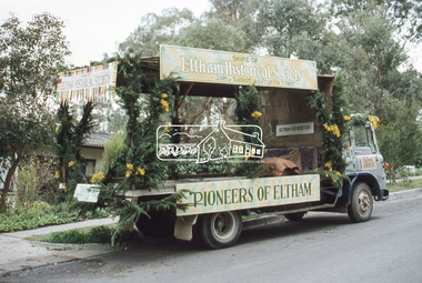
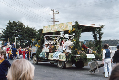
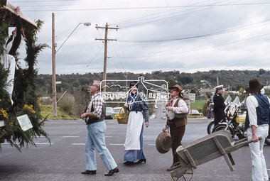
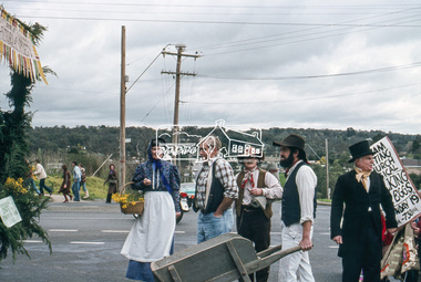
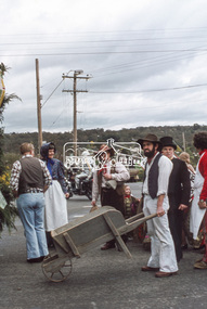
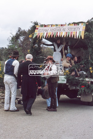
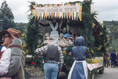
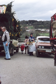
Slide, The Society's parade float outside 63 Batman Road, Eltham, 11 Aug 1979
The fifth Eltham Community Festival was held 11-20 August 1979. The theme of the festival was “Along the Main Road” and was the first time the Shire of Eltham Historical Society (forerunner of the Etham District Historical Society) entered a float in the Festival Grand Parade. The Society's participation in this year's Eltham Community Festival was highly successful. We arranged an exhibition in the Eltham Library on the theme of ''Along the Main Road" and our float in the Festival Grand Parade "Pioneers of Eltham" won the prize donated by Pegasus Interiors for the best Eltham theme. The success of the float was due mainly to the efforts of Joh Ebeli. Joh was entirely responsible for the design and artistic work on the float and with help from Geoffery Loftus-Hills and Mark Gough actually constructed it. Society members and friends together with members of the Victorian Folk Music Club completed the picture, riding on and walking with the float in the parade. Mrs. Opal Smith and Mrs. B. Brinkkotter organized many of the costumes for participating members and Mrs. Phyllis Macdonald made the arrangements with the Victorian Folk Music Club. Thanks were also due to Mr. P. Quirke of Research Fruit Supply for the loan of his truck and to Eltham Hardware and Plumbing Supplies for the donation of materials for construction of the float. The $50.00 prize was shared with the Victorian Folk Music Club. Following the success of this event, it was considered that future parades were an important annual event for the society to participate in. 35 mm colour positive transparency Mount - Agfachrome Professional black (Germany) 4 dotseltham festival, parade, parade floats, pioneers of eltham, eltham district historical society, shire of eltham historical society -
 Eltham District Historical Society Inc
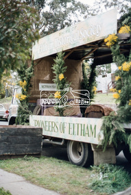
Slide, The Grand Parade assembles in Cecil Street, Eltham, Fith Eltham Community Festival, 11 Aug 1979
The fifth Eltham Community Festival was held 11-20 August 1979. The theme of the festival was “Along the Main Road” and was the first time the Shire of Eltham Historical Society (forerunner of the Etham District Historical Society) entered a float in the Festival Grand Parade. The Society's participation in this year's Eltham Community Festival was highly successful. We arranged an exhibition in the Eltham Library on the theme of ''Along the Main Road" and our float in the Festival Grand Parade "Pioneers of Eltham" won the prize donated by Pegasus Interiors for the best Eltham theme. The success of the float was due mainly to the efforts of Joh Ebeli. Joh was entirely responsible for the design and artistic work on the float and with help from Geoffery Loftus-Hills and Mark Gough actually constructed it. Society members and friends together with members of the Victorian Folk Music Club completed the picture, riding on and walking with the float in the parade. Mrs. Opal Smith and Mrs. B. Brinkkotter organized many of the costumes for participating members and Mrs. Phyllis Macdonald made the arrangements with the Victorian Folk Music Club. Thanks were also due to Mr. P. Quirke of Research Fruit Supply for the loan of his truck and to Eltham Hardware and Plumbing Supplies for the donation of materials for construction of the float. The $50.00 prize was shared with the Victorian Folk Music Club. Following the success of this event, it was considered that future parades were an important annual event for the society to participate in. 35 mm colour positive transparency Mount - Agfachrome Professional black (Germany) 4 dotseltham festival, parade, parade floats, pioneers of eltham, eltham district historical society, shire of eltham historical society -
 Eltham District Historical Society Inc
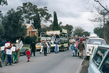
Slide, Grand Parade, Fifth Eltham Community Festival, 11 Aug 1979
The fifth Eltham Community Festival was held 11-20 August 1979. The theme of the festival was “Along the Main Road” and was the first time the Shire of Eltham Historical Society (forerunner of the Etham District Historical Society) entered a float in the Festival Grand Parade. The Society's participation in this year's Eltham Community Festival was highly successful. We arranged an exhibition in the Eltham Library on the theme of ''Along the Main Road" and our float in the Festival Grand Parade "Pioneers of Eltham" won the prize donated by Pegasus Interiors for the best Eltham theme. The success of the float was due mainly to the efforts of Joh Ebeli. Joh was entirely responsible for the design and artistic work on the float and with help from Geoffery Loftus-Hills and Mark Gough actually constructed it. Society members and friends together with members of the Victorian Folk Music Club completed the picture, riding on and walking with the float in the parade. Mrs. Opal Smith and Mrs. B. Brinkkotter organized many of the costumes for participating members and Mrs. Phyllis Macdonald made the arrangements with the Victorian Folk Music Club. Thanks were also due to Mr. P. Quirke of Research Fruit Supply for the loan of his truck and to Eltham Hardware and Plumbing Supplies for the donation of materials for construction of the float. The $50.00 prize was shared with the Victorian Folk Music Club. Following the success of this event, it was considered that future parades were an important annual event for the society to participate in. 35 mm colour positive transparency Mount - Agfachrome Professional black (Germany) 4 dotseltham festival, parade, parade floats, pioneers of eltham, eltham district historical society, shire of eltham historical society -
 Eltham District Historical Society Inc
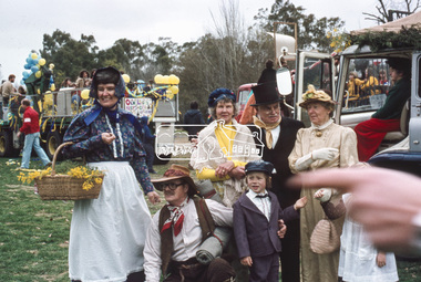
Slide, Grand Parade, Fifth Eltham Community Festival, 11 Aug 1979
The fifth Eltham Community Festival was held 11-20 August 1979. The theme of the festival was “Along the Main Road” and was the first time the Shire of Eltham Historical Society (forerunner of the Etham District Historical Society) entered a float in the Festival Grand Parade. The Society's participation in this year's Eltham Community Festival was highly successful. We arranged an exhibition in the Eltham Library on the theme of ''Along the Main Road" and our float in the Festival Grand Parade "Pioneers of Eltham" won the prize donated by Pegasus Interiors for the best Eltham theme. The success of the float was due mainly to the efforts of Joh Ebeli. Joh was entirely responsible for the design and artistic work on the float and with help from Geoffery Loftus-Hills and Mark Gough actually constructed it. Society members and friends together with members of the Victorian Folk Music Club completed the picture, riding on and walking with the float in the parade. Mrs. Opal Smith and Mrs. B. Brinkkotter organized many of the costumes for participating members and Mrs. Phyllis Macdonald made the arrangements with the Victorian Folk Music Club. Thanks were also due to Mr. P. Quirke of Research Fruit Supply for the loan of his truck and to Eltham Hardware and Plumbing Supplies for the donation of materials for construction of the float. The $50.00 prize was shared with the Victorian Folk Music Club. Following the success of this event, it was considered that future parades were an important annual event for the society to participate in. 35 mm colour positive transparency Mount - Agfachrome Professional black (Germany) 4 dotseltham festival, parade, parade floats, pioneers of eltham, eltham district historical society, shire of eltham historical society