Showing 806 items
matching lake view
-
 Lakes Entrance Historical Society
Photograph - Bridges, Fish Marie, 1965
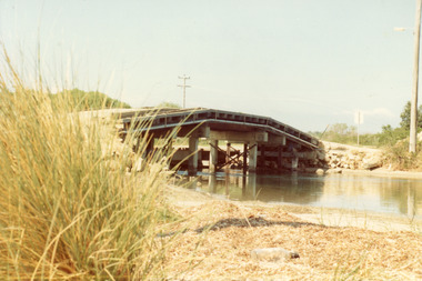
Also one other photograph, similar viewColour photograph of the first road bridge from Lakes Entrance to Bullock island, which was built for Public Works Dept. groyne building and sand build up to enlarge the island. Built early 1953. Lakes Entrance Victoria topography, bridges, islands, public works -
 Lakes Entrance Historical Society
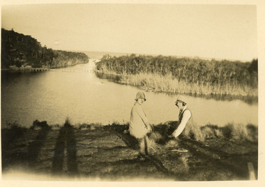
Postcard - tramline Lake Bunga, 1920
Small format black and white postcard showing a distant view of tramway bridge at Lakes Bunga, Victoria. Two women in foreground, image taken from Bunga Haven guesthouse.bridges, timber industry, waterways, tramline -
 Lakes Entrance Historical Society
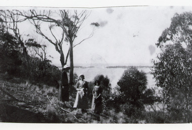
Photograph, 1920c
Black and white photograph showing three women at viewing site Kalimna of the Entrance to Bass Strait from the Gippsland Lakeswaterways, topography, people -
 Lakes Entrance Historical Society
Photograph - Comer's Landing
Black and white photograph of the North Arm at Comer's Landing, North Arm, showing a tree covered steep bank opposite Mrs Comer's Tea Rooms, viewed over the back of a tourist launch. Lakes Entrance Victoriarestaurant, tourism, waterways -
 Lakes Entrance Historical Society
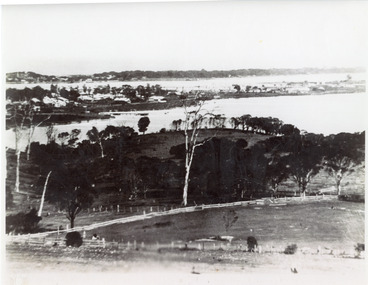
Photograph - Lakes Entrance, 1935c
Enlarged from postcard produced for Mrs Allen to advertise Allen's Tearoom at the brow of Myer St hill, known as Allen's Hill to locals.|This is the paired before photograph showing the left hand side on Butchers paddock in the panoramic views, the right hand side number 01715. This photograph used in the 150 year Lakes Entrance 1858-2008 display.Black and white photograph of the township, taken from Allen's Hill, Myer St. It shows the town between Cunninghame Arm and North Arm, cleared and fenced paddocks in foreground, New Works village and sand hummocks in distance. Lakes Entrance Victoria township, waterways, topography -
 Lakes Entrance Historical Society
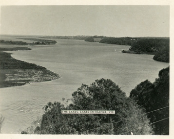
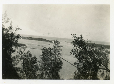
Postcard - Reeves Channel, Valentine Series, 1930c
... Other copy similar view with inscription 'The Lakes, Lakes...Other copy similar view with inscription 'The Lakes, Lakes ...Other copy similar view with inscription 'The Lakes, Lakes Entrance Vic'Black and white postcard of Reeves Channel Gippsland Lakes, showing Rigby, Fraser and Flannagan Islands opposite the steep shoreline of the mainland. Natural vegetation of Jemmys Point in foreground from which photograph was taken. Lakes Entrance VictoriaKalimna from Jemmys Point Lakes Entranceislands, waterways, topography -
 Lakes Entrance Historical Society
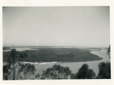
Photograph - Rigby Island, 1930c
Second copy similar viewBlack and white photograph of Rigby Island, Gippsland Lakes Victoria. It shows Reeves Channel on right of photo, Hopetoun Channel on left, The Narrows below Jemmys Point from which photo was taken. Lakes Entrance Victoriaislands, waterways, topography -
 Lakes Entrance Historical Society
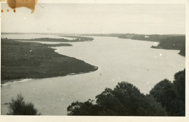
Photograph - Lake King, 1950c
Also copy of same view, stained, 9 x 14Black and white photograph of the Narrows and Reeves Channel of Lake King, Gippsland Lakes. It shows Rigby, Fraser, and Flannagan Islands opposite the steep shoreline of the mainland. Taken from Jemmy's Point, it shows a recently built groyne from Rigby Island into the Narrows. Lakes Entrance Victoriaislands, waterways, topography -
 Lakes Entrance Historical Society
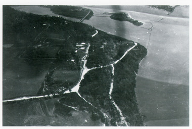
Photograph - Kalimna, Bulmer H D, 1940c
Black and white photograph of aerial view of Kalimna escarpment, Princes Highway, road to Kalimna Hotel, scattering of buildings including Gainsborough House, in distance is North Arm bridge, footbridge to undeveloped Bullock Island with rock groynes in place. Part of eastern pier of entrance at Lakes Entrance, Victoria. waterways, topography, township, bridges -
 Lakes Entrance Historical Society
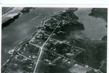
Photograph - Lakes Entrance, Bulmer H D, 1940c
Black and white photograph of aerial view of township. It shows route of Princes Highway through town, turning north at Myer Street and continuing along Roadknight Street. Few jetties on North Arm, many on Cunninghame Arm. In far upper left of image sea is breaking on sand hummocks. Lakes Entrance Victoriawaterways, township -
 Lakes Entrance Historical Society
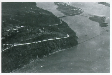
Photograph - Kalimna, Bulmer H D, 1940c
Black and white photograph of aerial view of Kalimna Heights, showing scattered buildings, Princes Highway around side of cliff, western end of township, North Arm bridge, footbridge to Bullock Island, and rock groynes. Track to lookout and signal beacon visible. Lakes Entrance Victoria waterways, roads and streets, bridges, township -
 Lakes Entrance Historical Society
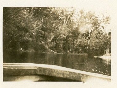
Photograph - North Arm, Phillips, Miss L, 1910c
... on water, distant view of township. Lakes Entrance Victoria... to island in lake, two small boats on water, distant view ...Black and white photograph of North Arm. It shows the reedy shoreline in foreground, jetty to island in lake, two small boats on water, distant view of township. Lakes Entrance Victoriawaterways, topography, vegetation -
 Lakes Entrance Historical Society
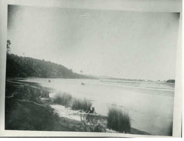
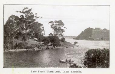
Photograph - North Arm, 1920c
Copy same view but titled 'North Arm - Lakes Entrance' 11.5 x 18Black and white photograph of the North Arm. It shows the calm waters of the arm which twist and turn between high scrub covered banks. Distant view of township, two people in small boat in foreground. Lakes Entrance VictoriaLakes Scene North Arm Lakes Entrancevegetation, topography, waterways -
 Lakes Entrance Historical Society
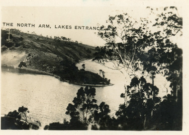
Postcard - North Arm, 1924
Second copy 6 x 8 with inscription 'North Arm Lakes Entrance'Black and white postcard of a view down the North Arm, showing the calm waters of the lake, natural vegetation in foreground, reflections of trees on the water. Lakes Entrance VictoriaThe North Arm Lakes Entrancewaterways, vegetation -
 Lakes Entrance Historical Society
Photograph - Entrance Piers, 1905c
Note on back - Dear Aggie, Met mother Friday evening, train arrived in Melbourne between 6 & 7. Jessie.Colour photograph showing early view of new wooden piers, a few people on pier and on beach. Strand of barbed wire across foreground. Lakes Entrance VictoriaCunninghame, Victoriaboardwalk, jetties, ocean, public works -
 Lakes Entrance Historical Society
Photograph - Wombat, 1890c
1 other photograph 10 x 16 archived.Black and white photograph showing view of entrance, dunes and Bullock Island, buildings and dunes at left, building and jetty and rock groynes on Bullock Island. Vessel near centre may be the Carpenter owned dredge the Wombat. Lakes Entrance Victoria jetties, dredges, waterways -
 Lakes Entrance Historical Society
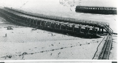
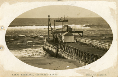
Postcard - Eastern Pier, Vogt, Stanley, 1910c
Oval shaped picture. Also other copies, oval shaped 12.5 x 17.5 cm and 17.5 x 25 cm. Also two black and white prints 9 x 13 cm.Sepia postcard in cameo image, showing early view of eastern pier at the entrance to Gippsland Lakes from ocean - Bass Strait, at Lakes Entrance, Victoria. Photo shows work shed and crane at end of wooden eastern pier, SS Wyralla at sea.Lakes Entrance, Gippsland Lakes machinery, waterways, piers, ships and shipping -
 Lakes Entrance Historical Society
Photograph - The Entrance, 1910c
also copies|Two black and white 8.5 x 14|Two black and white 16 x 25Sepia photograph showing view of entrance to Gippsland Lakes from ocean- Bass Strait, looking west towards Western Pier and dunes. Foreground on left shows gable roof of rocket shed and shipwreck bell on white post on right. Lakes Entrance Victoriawaterways, sandbar, rocket shed -
 Lakes Entrance Historical Society
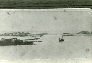
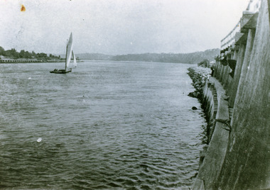
Photograph - The Entrance, 1922
Black and white photograph showing entrance and piers, viewed from ocean end of pier looking north towards Kalimna, small sailing boat in entrance inside of Eastern Pier, on right amongst the timber piers is a man leaning out. Lakes Entrance Victoria waterways, piers, boats and boating -
 Lakes Entrance Historical Society
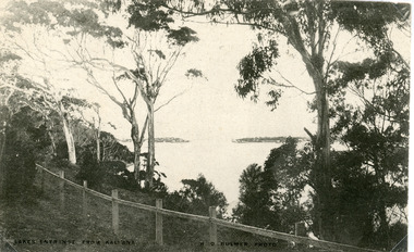
Postcard - The Entrance, Bulmer H D, 1910c
Black and white postcard of the man made entrance through the hummocks, taken from the cliff top at Kalimna. Shows an indistinct distant view of the entrance, natural vegetation in foreground behind simple timber and chicken wire boundary fence. Lakes Entrance VictoriaLakes Entrance from Kalimnawaterways, topography, islands -
 Lakes Entrance Historical Society
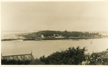
Postcard - The Entrance, 1935c
Also small format identical postcard 6.5 x 8.5, very faded,|also small format photo, same view donated by D & M FletcherBlack and white small format postcard of the man made entrance to the Gippsland Lakes, taken from Jemmys Point. It shows the rock groynes beside Bullock Island, a barge in North Arm below Jemmys Point. Lakes Entrance VictoriaThe Entrance to Gippsland Lakes waterways, topography -
 Lakes Entrance Historical Society
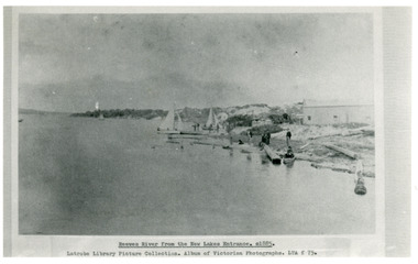
Photograph - Reeves River
Black and white photograph showing building, boats, and workmen at site of proposed New Entrance. View of Reeves River, later called Cunninghame Arm, looking east towards natural entrance. Lakes Entrance VictoriaReeves River from the New Lakes Entrance 1885c waterways, public works -
 Lakes Entrance Historical Society
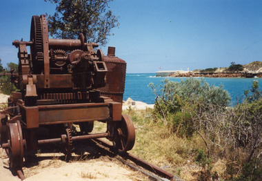
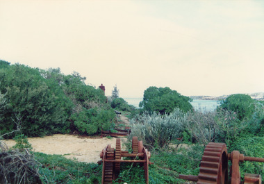
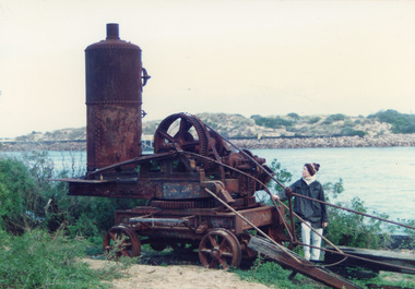
Photograph - Historic Site, Fish, Marie, 2000c
Also three views of old machinery.Colour photograph showing rusted remains of the travelling crane at the entrance. Steam boiler removed, placed to the side. Crane on tramway rails, entrance and western pier in background. Lakes Entrance Victoriamachinery, piers -
 Lakes Entrance Historical Society
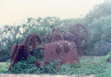
Photograph - Historic Site, Fish, Marie, 2000c
Also three views of old machinery.Colour photograph showing rusted remains of the travelling crane at the entrance Lakes Entrance Victoria islands, waterways, machinery -
 Lakes Entrance Historical Society
Photograph - Historic Site, Fish, Marie, 2000c
Also three views of old machinery.Colour photograph showing rusted remains of the travelling crane at the entrance Lakes Entrance Victoria islands, waterways, machinery -
 Lakes Entrance Historical Society
Photograph - Historic Site, Fish, Marie, 2000c
Also three views of old machinery.Colour photograph showing rusted remains of the travelling crane at the entrance Lakes Entrance Victoriamachinery, vegetation -
 Lakes Entrance Historical Society
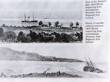
Photograph - Natural Entrance
Black and white photographic postcard of an illustrative collage of two wood engravings, one showing view of the Western Spit of the natural entrance, with a steamer anchored and three cottages on the bank. The second illustration shows the wreck of the trading schooner Latrobe, at the natural entrance. Lakes Entrance VictoriaView of the Western Spit, 1878 (Wood engraving form Australasian Sketcher, Sale Regional arts Centre)waterways, ships and shipping -
 Lakes Entrance Historical Society
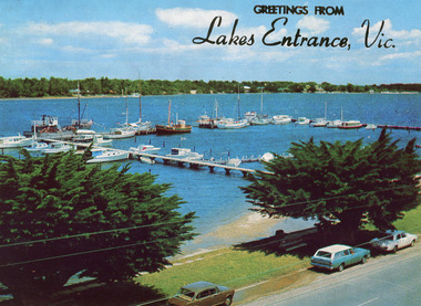
Postcard - Lakes Entrance, The Rose Series, 1975
... Colour postcard of the view of Cunninghame Arm, Lakes... Boats and Boating Jetties Waterfront Colour postcard of the view ...Sand dumping has commenced in preparation of works to modify and deepen Cunninghame Arm|Also one other copyColour postcard of the view of Cunninghame Arm, Lakes Entrance, from the Glenara Tower. Shows the western boat harbour with private cruisers and professional fishing vessels moored at wharf. Lakes Entrance Victoriawaterways, boats and boating, jetties, waterfront -
 Lakes Entrance Historical Society
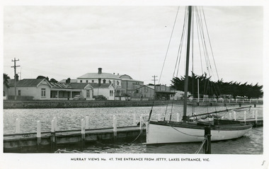
Postcard - Lakes Entrance, Murray Views, 1965
... . Lakes Entrance Victoria Postcard Lakes Entrance Murray Views ...Black and white postcard taken from a jetty on Cunninghame Arm, Lakes Entrance, showing Esplanade from Bellevue Guest House to Prince Regent Theatre and six of the World War 1 memorial cypress trees. Yacht at jetty in foreground. Lakes Entrance VictoriaEntrance from Jetty, Lakes Entrance, Victoriawaterfront, jetties, township, hotels -
 Lakes Entrance Historical Society
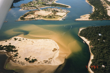
Photograph - Lakes Entrance, 1997
Date made 7 July 1997Colour photograph being an aerial view of the western end of Cunninghame Arm, showing the entrance between the hummocks, Bullock Island, entrance to North Arm, Snake Island surrounded by sand build-up. Lakes Entrance Victoriatopography, waterways, aerial photograph, boats and boating, township, islands