Showing 548 items
matching mcmillan street
-
 Kew Historical Society Inc
Plan - Subdivision Plan, J R Mathers & McMillan, Clutha Subdivision, 1940
Pru Sanderson, in her groundbreaking ‘City of Kew Urban Conservation Study : Volume 2 - Development History’ (1988), summarised the periods of urban development and subdivisions of land in Kew. The periods that she identified included 1845-1880, 1880-1893, 1893-1921, 1921-1933, 1933-1943, and Post-War Development. These periods were selected as they represented periods of rapid growth or decline in urban development. An obvious starting point for Sanderson’s groupings involved population growth and the associated economic cycles. These cycles also highlighted urban expansion onto land that was predominantly rural, although in other cases it represented the decline and breakup of large estates. A number of the plans in the Kew Historical Society’s collection can also be found in other collections, such as those of the State Library of Victoria and the Boroondara Library Service. A number are however unique to the collection.The Kew Historical Society collection includes almost 100 subdivision plans pertaining to suburbs of the City of Melbourne. Most of these are of Kew, Kew East or Studley Park, although a smaller number are plans of Camberwell, Deepdene, Balwyn and Hawthorn. It is believed that the majority of the plans were gifted to the Society by persons connected with the real estate firm - J. R. Mathers and McMillan, 136 Cotham Road, Kew. The Plans in the collection are rarely in pristine form, being working plans on which the agent would write notes and record lots sold and the prices of these. The subdivision plans are historically significant examples of the growth of urban Melbourne from the beginning of the 20th Century up until the 1980s. A number of the plans are double-sided and often include a photograph on the reverse. A number of the latter are by noted photographers such as J.E. Barnes.The subdivision plan for the Clutha Subdivision is one of the largest in the Society’s collection. The plan includes a map of the proposed allotments, photographic views to the north and south, and information about the kinds of buildings that could be constructed on the allotments. The subdivision was bounded by Studley Park Road, and Carson, Stevenson and Edgecombe Streets. Two new streets, Mackie Court and Younger Street were created as part of the subdivision. The subdivision took its name from ‘Clutha’, the home of John Carson, who was to become Mayor of Kew in 1863. A Report to the City of Boroondara outlined how: ‘The Clutha estate was progressively developed from 1940, with new houses under construction on the Studley Park Road, Carson and Edgecombe Street frontages by 1941. By 1943, directory listings were available for all addresses with the exception of Mackie Court. Building ceased after the government’s prohibition on civilian building was enforced from 1942, with little change in listings until the 1950s when the remainder of the subdivision was developed’."H"subdivisions - kew - studley park, clutha subdivision, studley park road -
 Kew Historical Society Inc
Plan - Subdivision Plan, Jas R Mathers Son & McMillan, Macartney Estate, East Kew, c. 1925
Pru Sanderson, in her groundbreaking ‘City of Kew Urban Conservation Study : Volume 2 - Development History’ (1988), summarised the periods of urban development and subdivisions of land in Kew. The periods that she identified included 1845-1880, 1880-1893, 1893-1921, 1921-1933, 1933-1943, and Post-War Development. These periods were selected as they represented periods of rapid growth or decline in urban development. An obvious starting point for Sanderson’s groupings involved population growth and the associated economic cycles. These cycles also highlighted urban expansion onto land that was predominantly rural, although in other cases it represented the decline and breakup of large estates. A number of the plans in the Kew Historical Society’s collection can also be found in other collections, such as those of the State Library of Victoria and the Boroondara Library Service. A number are however unique to the collection.Subdivision plans are historically important documents used as evidence of the growth of suburbs in Australia. They frequently provide information about when the land was sold on which a built structure was subsequently constructed as well as evidence relating to surveyors and real estate and financial agents. The numerous subdivision plans in the Kew Historical Society's collection represent working documents, ranging from the initial sketches made in planning a subdivision to printed plans on which auctioneers or agents listed the prices for which individual lots were sold. In a number of cases, the reverse of a subdivision plan in the collection includes a photograph of a house that was also for sale by the agent. These photographs provide significant heritage information relating house design and decoration, fencing and household gardens.The Macartney Estate subdivision advertised 21 lots for sale on either side of Macartney Street (now Macartney Avenue) and Evans Road in what was then designated as East Kew. Most of the houses shown on the south side of Macartney Street then, as now, have rear entrances on Mount Street, however a number of these blocks have since been further subdivided to allow for the building of new houses on the rear of a block. Brougham Place is marked on the plan but is now called Daniell Place."C"subdivision plans - east kew, macartney estate, macartney street, mount street, evans road, brougham place -
 Kew Historical Society Inc
Plan - Subdivision Plan, J R Mathers & McMillan, Glenarbor Estate, 1934
Pru Sanderson, in her groundbreaking ‘City of Kew Urban Conservation Study : Volume 2 - Development History’ (1988), summarised the periods of urban development and subdivisions of land in Kew. The periods that she identified included 1845-1880, 1880-1893, 1893-1921, 1921-1933, 1933-1943, and Post-War Development. These periods were selected as they represented periods of rapid growth or decline in urban development. An obvious starting point for Sanderson’s groupings involved population growth and the associated economic cycles. These cycles also highlighted urban expansion onto land that was predominantly rural, although in other cases it represented the decline and breakup of large estates. A number of the plans in the Kew Historical Society’s collection can also be found in other collections, such as those of the State Library of Victoria and the Boroondara Library Service. A number are however unique to the collection.The Kew Historical Society collection includes almost 100 subdivision plans pertaining to suburbs of the City of Melbourne. Most of these are of Kew, Kew East or Studley Park, although a smaller number are plans of Camberwell, Deepdene, Balwyn and Hawthorn. It is believed that the majority of the plans were gifted to the Society by persons connected with the real estate firm - J. R. Mathers and McMillan, 136 Cotham Road, Kew. The Plans in the collection are rarely in pristine form, being working plans on which the agent would write notes and record lots sold and the prices of these. The subdivision plans are historically significant examples of the growth of urban Melbourne from the beginning of the 20th Century up until the 1980s. A number of the plans are double-sided and often include a photograph on the reverse. A number of the latter are by noted photographers such as J.E. Barnes.The little-known Glenarbor Estate comprised 23 allotments bordering Wellington and Denmark Streets and Fenton Avenue. The auction of the allotments in the Estate was held in the Kew Recreation Hall. The purported advantages to Kew are identified on the plan, such as the close proximity of the entrance to the Kew Railway Station and access to shops in Denmark Street. Due to its location, the subdivision was pitched at commercial as well as residential purchasers. The Estate was to cause a crisis in the Kew Council as a majority of councillors voted on 29 May to acquire the entire Estate as the location of a new Town Hall. The Estate was said to be valued at £50,000. A later meeting was to rescind the vote, instead opting for the compulsory acquisition of South Esk on the corner of Charles Street and Cotham Road. That acquisition was to be overturned by the State Government. The debate about the purchase of the Glenarbor Estate by Council coincided with the decision to widen High Street on the South side between Cotham Road and the Junction."D"subdivision plans - kew, glenarbor estate, wellington street, denmark street -
 Kew Historical Society Inc
Plan - Subdivision Plan, Jas R Mathers Son & McMillan, The Dale Estate, Deepdene, 1918
Pru Sanderson, in her groundbreaking ‘City of Kew Urban Conservation Study : Volume 2 - Development History’ (1988), summarised the periods of urban development and subdivisions of land in Kew. The periods that she identified included 1845-1880, 1880-1893, 1893-1921, 1921-1933, 1933-1943, and Post-War Development. These periods were selected as they represented periods of rapid growth or decline in urban development. An obvious starting point for Sanderson’s groupings involved population growth and the associated economic cycles. These cycles also highlighted urban expansion onto land that was predominantly rural, although in other cases it represented the decline and breakup of large estates. A number of the plans in the Kew Historical Society’s collection can also be found in other collections, such as those of the State Library of Victoria and the Boroondara Library Service. A number are however unique to the collection.The Kew Historical Society collection includes almost 100 subdivision plans pertaining to suburbs of the City of Melbourne. Most of these are of Kew, Kew East or Studley Park, although a smaller number are plans of Camberwell, Deepdene, Balwyn and Hawthorn. It is believed that the majority of the plans were gifted to the Society by persons connected with the real estate firm - J. R. Mathers and McMillan, 136 Cotham Road, Kew. The Plans in the collection are rarely in pristine form, being working plans on which the agent would write notes and record lots sold and the prices of these. The subdivision plans are historically significant examples of the growth of urban Melbourne from the beginning of the 20th Century up until the 1980s. A number of the plans are double-sided and often include a photograph on the reverse. A number of the latter are by noted photographers such as J.E. Barnes.The Dale Estate in Deepdene was made possible by the death of Robert Sparrow Smythe, Australian journalist, newspaper editor/owner and theatrical manager. Smythe lived in his residence ‘Highate’, Deepdene until his death in 1917. In the subdivision proposed one year later, before the end of the First World War, 18 allotments were to be created. The very fragmentary plan in the Society’s collection notes that a large weatherboard [house] will need to be removed. This may be Smythe’s own home. The proposed subdivision included allotments facing Burke and Whitehorse Roads and Dale Street. Bordering the subdivision is the Deepdene Station and the Outer Circle Railway Line. The clear directions on the plan indicate that in 1918 it was possible to travel by train from Deepdene to East Camberwell and Ashburtonsubdivision plans - deepdene, the dale estate -
 Kew Historical Society Inc
Plan - Subdivision Plan, Plan of Subdivision of Part of Crown Portion 84 / Parish of Boroondara / County of Bourke / Lodged Plan No. 2217, Twentieth Century
Pru Sanderson, in her groundbreaking ‘City of Kew Urban Conservation Study : Volume 2 - Development History’ (1988), summarised the periods of urban development and subdivisions of land in Kew. The periods that she identified included 1845-1880, 1880-1893, 1893-1921, 1921-1933, 1933-1943, and Post-War Development. These periods were selected as they represented periods of rapid growth or decline in urban development. An obvious starting point for Sanderson’s groupings involved population growth and the associated economic cycles. These cycles also highlighted urban expansion onto land that was predominantly rural, although in other cases it represented the decline and breakup of large estates. A number of the plans in the Kew Historical Society’s collection can also be found in other collections, such as those of the State Library of Victoria and the Boroondara Library Service. A number are however unique to the collection.The Kew Historical Society collection includes almost 100 subdivision plans pertaining to suburbs of the City of Melbourne. Most of these are of Kew, Kew East or Studley Park, although a smaller number are plans of Camberwell, Deepdene, Balwyn and Hawthorn. It is believed that the majority of the plans were gifted to the Society by persons connected with the real estate firm - J. R. Mathers and McMillan, 136 Cotham Road, Kew. The Plans in the collection are rarely in pristine form, being working plans on which the agent would write notes and record lots sold and the prices of these. The subdivision plans are historically significant examples of the growth of urban Melbourne from the beginning of the 20th Century up until the 1980s. A number of the plans are double-sided and often include a photograph on the reverse. A number of the latter are by noted photographers such as J.E. Barnes.Undated Plan of Subdivision of Crown Portion 84 in what is now Kew. The area shown is bordered by Burke Road, Harp Road, Arglye Road and Normanby Road.subdivision plans -- kew (vic), harp road, burke road, normanby road, lady loch's drive, gladstone street, second avenue, first avenue -
 Surrey Hills Historical Society Collection
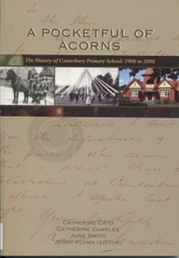
Book, A Pocketful of Acorns - This History of Canterbury Primary School : 1908-2008, c 2008
Purchased in memory of Sue Slonek, Secretary of Surrey Hills Historical Society, volunteer with the Surrey Hills Neighborhood Centre Heritage Collection (Surrey Hills historical Society Collection). A history of Canterbury Primary School written to celebrate the school's 100 year anniversary - 1908-2008A history of Canterbury Primary School written to celebrate the school's 100 year anniversary - 1908-2008canterbury primary school, primary schools, (ms) judy stewart, (mr) ian phillips, (miss) gabriela aloisio, (mrs) marjorie pitt, (miss) joan eltham, (mr) - shannon, (mr) - besant, (mrs) anne bialecki, (ms) diane western, (ms) margaret mason, (miss) hilary barr, (mrs) hilary praetz, (ms) vicki eddison, (miss) margaret kidd, (mr) don kerr, (miss) sarah pitman, (miss) linda summers, (mr) jack tanner, (miss) kate dale, (mr) strapper tanner, (ms) neva rossi, (miss) margot harris, (miss) lauren eddison, (mr) eric alway, (miss) jean alway, (miss) betty alway, (mr) thomas rule, (miss) diane fuller, (ms) barbara chapman, (ms) judy bridges, (ms) julie vango, (ms) judy pitman, (ms) joan le grand, (ms) anne lamborn, (mr) warren walsh, (ms) margaret lee, (ms) barbara gunn, (ms) christine hallman, (mr) murray haby, chris roth, (ms) sue de araugo, (ms) leslie brewer, (ms) judy jordan, sam paterson, (ms) debbie-jane andrews, (mrs) hazel young, (ms) ilse murrihy, (ms) linda summers, (mrs) georgia karatzas, (mrs) sylvia clarke, (mr) eddie clarke, (mrs) - willoughby, (mr) - hopkins, (mrs) - hopkins, (mr) graham salter, (ms) andrea thompson, (miss) - stent, (miss) - mcdonald, (mr) neville daynes, (mr) bruce margetts, (miss) doris thomas, (miss) hazel macdonald, (miss) annette mccoy, (mrs) - feldt, (miss) arwen summers, (miss) grace cameron-muller, manon merakis, terry poulton, (mr) david tolstrup, (ms) sue broadbent, (miss) florence rayment, (miss) yvonne wray, (miss) hazel jarvis, (mr) graham scott, (miss) june smith, (mrs) margaret anderson, (miss) margaret ginn, (miss) kelly jane, (mrs) patricia wion, (miss) patricia lewis, (miss) - edgoose, (mr) john merton, (ms) pauline flynn, (ms) lynne timms, (ms) marilyn taylor, (mrs) anne tonkin, (mrs) flo wilkinson, (miss) flo davies, (mr) jack hardy, (mr) john a bayford, (miss) marion greenwood-smith, (miss) - mcevitt, (miss) - ballantyne, (miss) - riseborough, (ms) (dr) kim dray, (miss) dorothy ambrose, (mrs) - lethbridge, (mrs) - le couteur, (mrs) margaret senior, (miss) margaret macgibbon, (mrs) - briggs, (mr) (major) - moloney, (mr) - poulton, (mr) adrian penniston-bird, prospect hill road, surrey hills, canterbury, canterbury road, molesworth street, highfield road, leeds street, salisbury street, (mr) patrick moloney, (mr) thomas rule, (mr) richard armitage, (mr) frank l oswell, (mr) walter g w webb, (mr) edward bright, (mr) george a allison, (mr) albert r coppin, (mr) william a lucas, (mr) alan g legg, (mr) ralph holden, (mr) dorothy ambrose, (mr) robert storey, (mr) tom neal-williams, (mr) effie miniati, (mr) geoffrey swift, (mr) - baddeley, (mrs) helen mcmillan, (miss) helen mcgibbon, (mr) don walker, (mr) howard hallo, (miss) jean cowen, (miss) felicity coleman, (miss) amanda colahan, (miss) caitlin sum, (miss) brooke webster, (miss) bridget hall, (miss) alison thompson, (mr) andrew lovitt, (mrs) barbara mihan, (miss) barbara prest, (mr) john webster, (mrs) lorna whalley, (mr) stuart margetts, (miss) elaine robinson, (mrs) nonie holman, (miss) nonie lovitt, (mr) brian webster, (mrs) alison cutter, (miss) alison horwell, (mrs) jaqueline lublin, (miss) jacqueline levy, (mrs) gilliam bell, (miss) gillian craig, pinus radiata, the secret garden, lych gate, (mr) geoff swan, talbet oaks, bedford oaks, significant trees, burgundy ash, allepo pine, golden ash, southey oaks, poulton oaks, (mr) (sgt) keith mcdowell, wattle park, (ms) caroline habgood, (mr) henry rotherham, j b cohen, (mr) (major) patrick moloney, (miss) dorothy ambrose, architects, wurundjeri william territory, (mr) - sachse, d kinnaird, builders, danks foundation, (dr) desmond gibbs, 1908, sue slonek, catherine cato, catherine charles, june smith, jenny flynn -
 The Beechworth Burke Museum Research Collection
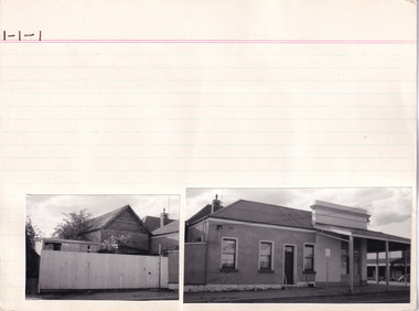
Card (Series) - Index Card, George Tibbits, Camp Street (Cnr Camp & High Streets), Beechworth, 1976
George Tibbits, University of Melbourne. Faculty of Architecture, Building and Town & Regional PlanningIndex system that support the research for Beechworth : historical reconstruction / [by] George Tibbits ... [et al]Arranged by street names of BeechworthEach index card includes: street name and number of property, image of property, allotment and section number, property owners and dates of ownership, description of the property according to rate records, property floor plan with dimensions.beechworth, george tibbitsbeechworth, george tibbits -
 Linton and District Historical Society Inc
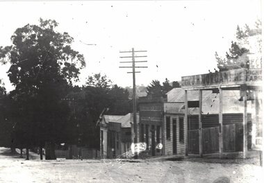
Photograph, Shops in Sussex Street, Linton, circa 1922
Black and white copy of original photograph which shows the shop in Sussex Street owned by J. H. Morgan, the shop and dwelling owned by Richard Ching (telegraph pole in front), and the shop and dwelling owned by Annie Brown (née Nicholls). A small building between Ching's and Brown's shops may be the workshop of Dan McMillan, bootmaker. What appears to be a laneway between the Morgan shop and the Ching dwelling was once occupied by the Surface Hill Hotel (demolished c.1911). Shops in Sussex Street, Linton, c.1922: Morgan's, Ching's, Brown's. The original Bank of New South Wales building (by 1922 a private residence owned by the Lewers family) can just be seen further along the street, screened by a large tree.On reverse:"J. H. Morgans store Sussex St Linton c.1922".annie brown (née nicholls), j.h. morgan, richard ching, dan mcmillan