Showing 11568 items matching " re-survey"
-
 University of Melbourne, Burnley Campus Archives
Document, Correspondence re Scoresby proposal, 1946-1949
Notes, letters and memoranda re Horticultural research Station at Scoresby for CRTS studentsscoresby, crts, students, horticultural research station -
 Queenscliffe Maritime Museum
Mixed media, News articles & pamphlets re Port Phillip Pilots c1839 onwards, Newspapers
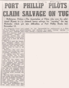
Port Phillip Sea PilotsHistorical newspaper clippings about Port Phillip's Sea Pilots' history.News articles & notices re Port Phillip's Sea Pilots over the years Reverse " NIL ".historical references -
 Bendigo Military Museum
Photograph - Lithographic Technicians preparing a Cromalin map proof at the Army Survey Regiment, Fortuna Villa Bendigo, c1990s
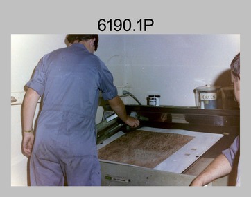
These six photographs were most likely taken in the 1990s in Lithographic Squadron at the Army Survey Regiment, Fortuna, Bendigo. There is no annotation describing the date or personnel in the photographs. Cromalin proofing was a laminate and dry powder proofing system introduced in 1978. The system allowed the production of true to colour proofs, mainly for the proofing of orthophoto maps and process printed 1:250,000 JOG that used positive printing plates. It was upgraded in 1986. The pre-press proof was a cost-effective way of producing a one-off visual copy of the map or chart product. It enabled cartographers to perform a quality inspection and correct any faults before publication. The pre-press proof was deemed authoritative before its release to Print Troop for bulk printing and distribution.This is a set of six photographs of lithographic technicians preparing Cromalin map proofs at the Army Survey Regiment, Bendigo c1990s. The photographs were on 35mm negative film and were scanned at 96 dpi. They are part of the Army Survey Regiment’s Collection. .1) to .6) - Photo, colour, c1990s, printer technician SPR Shona Hastie, Lithographic Squadron. .1P to .6P – no annotationroyal australian survey corps, rasvy, army survey regiment, army svy regt, fortuna, asr, litho -
Whitehorse Historical Society Inc.
Document, Division of Survey and Mapping, 1984
A brief guide to Crown Lands And Survey records commonly used for family history research.A brief guide to Crown Lands And Survey records commonly used for family history research.A brief guide to Crown Lands And Survey records commonly used for family history research.crown lands, victorian government, land surveys -
 Ringwood RSL Sub-Branch
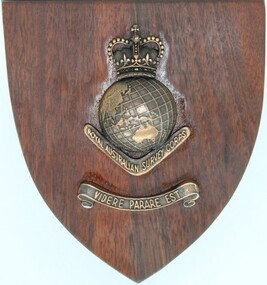
Souvenir - Wooden Plaque, Royal Australian Survey Corps
Wood plaque with brass fittings. Royal Australian Army Survey Corp post 1954 -
 Bendigo Military Museum
Administrative record - Royal Australian Survey Corps - Planning for Field Survey Operations for 1:250,000 - LtCol JK Herridge (RASvy) 1960, LtCol JB Herridge (RASvy), April 1960
This 13 x page document contains notes on planning for RASvy Field Survey Operations in Northern Command during 1958 and 1959 with helicopter support available for field operations for 1:250,000 mapping. The Document was written by LtCol JB Herridge (RASvy) at the School of Military Survey Balcombe April 1960.13 x foolscap pages of typed text, stapled and four holed punchedHand written "53" in top RH cornerroyal australian survey corps, rasvy, fortuna, army survey regiment, army svy regt, asr, school of military survey, sms -
 Linton and District Historical Society Inc
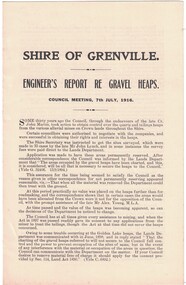
Report, Shire of Grenville, Engineer's Report re Gravel Heaps, 7th July 1916
Single sheet approximately A4 in size, folded to form four pages. Three-page report prepared by M. Martin, Shire Engineer, detailing the advisability of and legal basis for the Shire of Grenville retaining control of various quartz and tailing heaps (remnants of mining) located throughout the Shire.Text: " SHIRE OF GRENVILLE. / ENGINEER'S REPORT RE GRAVEL HEAPS. / COUNCIL MEETING, 7th JULY, 1916. "shire of grenville, gravel heaps, mining, roads -
 Ringwood and District Historical Society
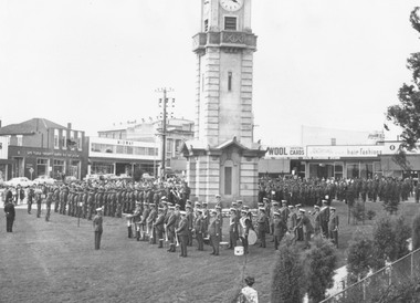
Photograph, Ringwood Clocktower re-opening ceremony, Cnr Maroondah Hwy and Wantirna Road, Ringwood - December 1967
Black and white photographImage shows Band members and other personalities assembled around clocktower during re-opening ceremony. -
 Kiewa Valley Historical Society
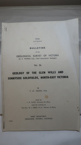
Document - Four Geological reports on the North-east Goldfields, Geological Survey of Victoria 1958 Bulletin
Geological Surveys of N.E. Goldfields Victoria included mines and tunnels. A resurvey of goldfields was necessary to re-assess economic possibilities using modern techniques and structural interpretation. It included an examination of a considerable surface area with maps and underground workings. Results were correlated and integrated and published by the Mines Department.The mines are in the Bogong Alpine Area.Foolscap printed Victorian Bulletins. Each stapled in the top left corner and each with varying number of pages. Covering 1941-1958 a) Glen Wills and Sunnyside b) Sunnyside Tunnel c) Red Robin d) Maud and Yellow Girl Government Printer, Mines Department, Melbourne, Victoriageology in the north-east, gold fields, goldmines, glen wills -
Whitehorse Historical Society Inc.
Article, Council 're-think' on heated pool plan, 1974
Nunawading Council is 're-thinking' the proposal for a 50metre indoor heated pool in Forest Hill.Nunawading Council is 're-thinking' the proposal for a 50metre indoor heated pool in Forest Hill.Nunawading Council is 're-thinking' the proposal for a 50metre indoor heated pool in Forest Hill.swimming pools, city of nunawading, forest hill -
 Queenscliffe Maritime Museum
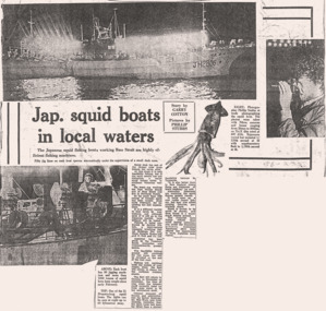
Mixed media - Japanese squid boats, Empress of the Sea & Capt. Paterson's funeral, News articles re squid boat, Empress of the Sea & a funeral, Newspapers
Shipwreck & rescues, funeral & Japanese squid fishermen.Empress of the Sea, Capt. Paterson [Pilot] & squid fishersNews articles & notices re Squid fishermen, Pilot's funeral & Empress of the Sea burningReverse " NIL ".historical references -
 Queenscliffe Maritime Museum
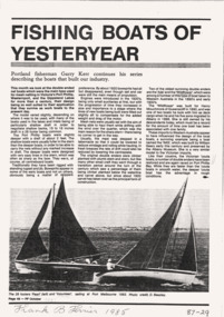
Magazine - Copy from Professional Fisherman pg.48 Oct.1985, 1985 Article by G Kerr re the original fishing boats of Port Phillip, 1985
Old fishing boatsfishing boatsCopy from Professional Fisherman pg.48 Oct.1985 re fishing boats.Reverse " NIL "historical references -
 Brimbank City Council Art Collection
Photograph, Re-enactment of the Gallipoli Landings, 1919 (original)
Photographic re-enactment of the Gallipoli Landings , staged at Saltwater River Anzac Day 1919inscription along bottom of picture -
Ringwood and District Historical Society
Envelope, Packet:4 letters re petrol pumps and storage 1926 to 1939 F. Kenworthy, T. Mathieson
4 letters re petrol pumps and storage 1926 to 1939 F. Kenworthy, T. Mathieson -
 Queenscliffe Maritime Museum
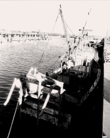
Photograph - Portarlington scallop boat, sunk & re-floated c1982, Scallop boat sunk & re-floated c1982, c1980
Scallop boats in Port Phillip.Re-floated scallop boat PORTARLINGTON4 x B&W photos of re-floated scallop boat PORTARLINGTON's at Queenscliffe Creek.Reverse " see each photo for details. "history, scallop boats, re-floated sunken boats -
 Queenscliffe Maritime Museum
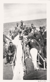
Photograph - B&W photos & news clippings re A T (Dick) Lee, Cuttings & photos re A T Lee, lighthouse keeper, c1977
Lighthouse keepersLighthouse keeper's life & timesB&W photos re A. T. (Dick) Lee, lighthouse keeper, Pt Lonsdale & Queenscliffe.Reverse " See Media scans. "history -
 Queenscliffe Maritime Museum
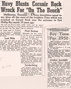
Mixed media - Wreck of the TIME, News articles re the wreck of the TIME, c1949 newspapers
Shipwreck & rescueSS TIME wreck, Corsair Reef & Queenscliffe Lifeboat.News articles, photos, map & report re SS TIME wreck at Corsair Reef c1949Reverse " NIL ".historical references -
 Queenscliffe Maritime Museum
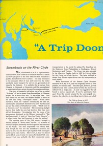
Pamphlet - Clyde River Scotland, Pamphlets, brochures and news article re travelling on the Clyde River Scotland
Clyde River boats ScotlandClyde River boatsColourt & B&W brochures, pamphlets & news article re boats on the Clyde River Scotland.Reverse " NIL "historical references -
 Greensborough Historical Society
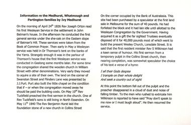
Manuscript, Ivy Medhurst, Information re the Medhurst Whatmough and Partington families by Ivy Medhurst, 24/04/1826
Family memoirs of a descendant of Greensborough pioneer families. Deals mainly with the Medhurst family connection with the Methodist (Wesleyan) Church.Explains the connection between the Medhurst family and the early history of the Wesleyan Church in Melbourne from the 1840s.20 page exercise book with handwritten family memoirs. Title handwritten on cover: Information re the Medhurst Whatmough and Partington families by Ivy Medhurst, daughter of David and Martha.medhurst family, ivy medhurst, methodist church, wesleyan church -
 Bendigo Military Museum
Poster - Map Production flow chart poster using Automap 2, Army Survey Regiment, Bendigo, 1982
This poster designed to be folded into a brochure describes the second phase of the computer assisted cartographic system to be used by the Royal Australian Survey Corps in the establishment of a topographic data base, Future tactical applications and map products using the data base are displayed. A topographic map of Series R631 1:100,000 Helenvale, Queensland printed on the reverse side that was produced by the Automap system using information from the topographic data base. This is the fifth edition of the poster.A multi colour poster of map production using the Automap 2 system. Poster shows a schematic and pictorial flow chart diagram of the stages of the map production process using the Automap 2 system. The poster was intended to be folded into a small brochure. A 1:100,000 Army Survey Map Series R631, 7966 Helenvale, Queensland Edition 2 is printed on the reverse side of the poster. The map is an example of one of the initial maps produced on the Automap 2 System at the Army Survey Regiment, Bendigo.royal australian survey corps, rasvy, fortuna, army survey regiment, army svy regt, asr, automap 2 -
Bendigo Historical Society Inc.
Map - GEOLOGICAL MAP OF BENDIGO GOLD FIELD
Two framed laminated maps (a,b) of Bendigo goldfield reef lines, map (b) is a continuation of the reef lines in map (a). On map(a) written in black on top: 'Geological Map, Bendigo Gold Field', Scale of chains, anticlines, synclines, shafts, alluvial and contours marked. Map (b) is continuation of (a). Written on the bottom RH corner of map: 'Prepared in 1923 in the Bendigo Office Mines Department under the direction of H. Herman, Director of Geological Surveys, from surveys by H.S. Whitelaw, Fiield Geologist, assisted by E.S. Usher & J. J. Moore. Re-issued in 1936.'H. Herman, Director of Geological Surveys, from surveys by H.S. Whitelaw, Fiield Geologist, assisted by E.S. Usher & J. J. Moore. Re-issued in 1936.'bendigo, mining, geological map. -
 Eltham District Historical Society Inc
Document - Folder, Survey Maps and Technical Drawings
alan gardiner collection, maps -
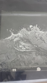 Peterborough History Group
Photograph - Aerial Photograph Peterborough, Department of Crown Lands & Survey, Jan 1971
Aerial photograph showing the past layout of the townSignificant in that it shows the town as it was in 1971.Square 9" x 9" aerial photograph x 4 - (2 photos in duplicate)Stamped Dept of Crown Lands & Surveypeterborough 3270, curdies estuary, bay of islands, crown land photograph, aerial photograph, department of crown lands -
 Rutherglen Historical Society
Document - License to thin trees, 1899 (Exact)
Dated July 14th 1899. Sent to Mr W. Cooper / c/o Mr Barrie / Storekeeper / No. 2 Valley / Chiltern / "Copy of Land Act 1896 / Regulations. Chapter XI Thinning Licenses"Document on stiff paper. Letter to Mr W. Cooper granting license to thin trees on a block of land at Chiltern Reserve. On back, copy of Land Act Regulations 1890"Department of Lands and Survey. On Forest Business"license, timber felling, cooper family, forestry, chiltern reserve -
Whitehorse Historical Society Inc.
Document, City of Nunawading Heritage Survey Project, 1/10/1994 12:00:00 AM
Database of places recognised in the field survey.Database of places recognised in the field survey. List of buildings, roads etc with indexes by value and by street name.Database of places recognised in the field survey. city of nunawading heritage survey, street name -
Whitehorse Historical Society Inc.
Document, Department of Crown Lands and Survey, 1983
Research guide of historical resources of the Department of Crown Lands and Survey. Compiled by P. Cabena, Aug 1983Research guide of historical resources of the Department of Crown Lands and Survey. Compiled by P. Cabena, Aug 1983Research guide of historical resources of the Department of Crown Lands and Survey. Compiled by P. Cabena, Aug 1983crown land, land surveys, victorian government -
Whitehorse Historical Society Inc.
Letter - Correspondence, Letter re land tax, Strathdon, 4/08/1961 12:00:00 AM
Letter from State Land Tax office to Mrs Mary Matheson re land on Springvale Road.Letter from State Land Tax office to Mrs Mary Matheson re land on Springvale Road.Letter from State Land Tax office to Mrs Mary Matheson re land on Springvale Road.matheson, mary, strathdon community -
 Queenscliffe Maritime Museum
Magazine - Copy from Professional Fisherman pg.43 Oct.1984, 1984 Article by G Kerr re Wooden Ships - Iron Men of Port Phillip, 1984
Old cray fishing boatsCray fishing boatsMagazine article by G Kerr re Wooden Ships & Iron Men aka Bass Strait CrayfishermenReverse " NIL "historical references -
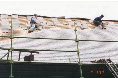 Buninyong & District Historical Society
Photograph - Colour photograph, re-roofing Holy Trinity Church, Buninyong, re-roofing Holy Trinity Church, Buninyong, Jan. 1997
Colour photo, Re-roofing of Holy Trinity Church, Buninyong by Hohn Murnane of Wendouree, Jan. 1997holy trinity church, roofing, murnane -
 Ringwood and District Historical Society
Article - Newspaper Clipping, Land Sale Advertisements, Golden Hill Estate, Ringwood - 1965, 1966, and Plan of Survey of Lot 8, Mullum Mullum Road Ringwood, 1970
Newspaper clippings from Melbourne Sun newspaper (11th December 1965 and 15th January 1966) advertising sale of land - Golden Hill Estate, Ringwood, with summary of features and aerial photograph including artistic representation of street layout. Subdivision includes Mullum Mullum Road, Sonia Street, Jill Court, Linda Drive, Eve Court, Alma Court, and Jacynthe Court. Attachments include reference to Lot 46 as site of original Peter Vergers' orchard residence and subsequent 1970 surveyor's Plan of Survey of Lot 8 Mullum Mullum Road Ringwood, LP 67513, Cert of Title 8581/429.Agent - Aaron, King & Co., Suite 2, 33 Queens Road, Melbourne. (Phone) 26-2443, A.H. 850-2195. Plan of Survey signed on 25.7.1970 by Roger M. Gamble, Land Surveyor, 28 Summit Crescent, Ringwood 3134.