Showing 1204 items
matching sale of land
-
 Gippsland Art Gallery
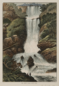
Print, Unknown Artist, The Berry Falls, Gipps Land, c.1878
Donated by Simon Gregg, 2013Hand-coloured wood engraving on papergippsland, artwork, permanent collection -
 Gippsland Art Gallery
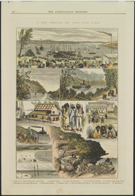
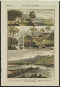
Print, Unknown Artist, A Trip Through Gipps Land Lakes, c.1880
Purchased, 1984Hand-coloured wood engraving on papergippsland, artwork, permanent collection -
 Gippsland Art Gallery
Print, Unknown Artist, Sale, Gipps Land, c.1881
... Sale, Gipps Land... Sale, Gipps Land Hand-coloured wood engraving on paper ...Donated by John Leslie OBE, 1984Hand-coloured wood engraving on papergippsland, artwork, permanent collection -
 Gippsland Art Gallery
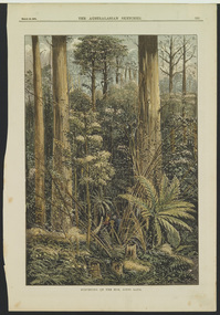
Print, Unknown Artist, Surveying on the Moe Gipps Land, c.1876
Purchased, 1984Hand-coloured wood engraving on papergippsland, artwork, permanent collection -
 Gippsland Art Gallery
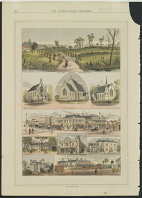
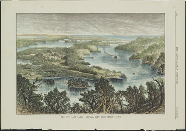
Print, Unknown Artist, The Gipps Land Lakes: General View from Jemmy's Point, 1878
... Gippsland Art Gallery 70 Foster Street Sale gippsland Print ...Purchased with the assistance of the Caltex Victorian Government Art Fund, 1984Hand-coloured wood engraving on papergippsland, artwork, permanent collection -
 Gippsland Art Gallery
Print, Unknown Artist, Views In North Gipps Land, c.1877
Donated by Peter Synan OAM, 1984Hand-coloured wood engraving on papergippsland, artwork, permanent collection -
 Gippsland Art Gallery
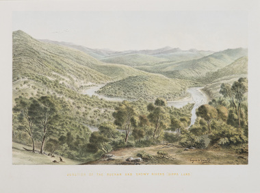
Print, Von Guerard, Eugene, Junction of the Buchan and Snowy Rivers (Gipps Land), c.1866-68
Purchased with the assistance of the Caltex Victorian Government Art Fund, 1982Coloured lithograph on papergippsland, artwork, permanent collection -
 Gippsland Art Gallery
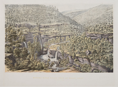
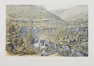
Print, Von Guerard, Eugene, Moroka River Falls (Foot of Mount Kent) (Gipps Land), c.1866-68
Purchased with the assistance of the Caltex Victorian Government Art Fund, 1984Coloured lithograph on papergippsland, artwork, permanent collection -
 Gippsland Art Gallery
Print, Von Guerard, Eugene, Moroka River Falls (Foot of Mount Kent) (Gipps Land), c.1866-68
Purchased with the assistance of the Gippsland Art Gallery Society, 2008Coloured lithograph on papergippsland, artwork, permanent collection -
 Gippsland Art Gallery
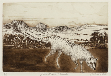
Print, Kline, Gillian, Van Diemen's Land, 2019
... Gippsland Art Gallery 70 Foster Street Sale gippsland Print ...Donated by the artist, 2019Etching and aquatint on papergippsland, artwork, permanent collection -
 Gippsland Art Gallery
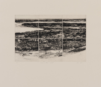
Print, Macpherson, Adelaide, Land & Water - Lakes, 2018
... Gippsland Art Gallery 70 Foster Street Sale gippsland Print ...Purchased, 2019White ground etching on papergippsland, artwork, permanent collection -
 Gippsland Art Gallery
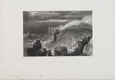
Print, Turner, J.M.W. (after), Land's End, Cornwall, c.1859-78
... Gippsland Art Gallery 70 Foster Street Sale gippsland Print ...Purchased, 2013Engraving on papergippsland, artwork, permanent collection -
 National Wool Museum
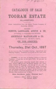
Catalogue, Catalogue of Sale of "Tooram" Estate, Allansford, 21st Oct, 1897
Catalogue of Sale of "Tooram" Estate, Allansford, 21st Oct, 1897, by Dennys Lascelles, Austin & Co and Archibald Macfarlane & CoT P WALSH annotationspastoral industry - history land enclosure, dennys, lascelles, austin & co archibald macfarlane & co, tooram, allansford, pastoral industry - history, land enclosure -
 National Wool Museum
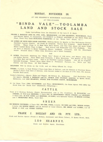
Brochure, "Binda Vale" Toolamba land and stock sale
... "Binda Vale" Toolamba land and stock sale..."Binda Vale" Toolamba land and stock sale Monday November... sale "Binda Vale" Toolamba land and stock sale Monday November ..."Binda Vale" Toolamba land and stock sale Monday November 28" Leo Kearneypastoral industry - history, binda vale, toolamba -
 National Wool Museum
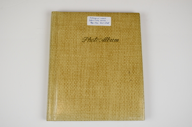
Photo Album, 1930-1934
The Photo Album was created by Hans Beck, who interned with the donor's father (Wilhelm Eckels). The Photo Album depicts wool buying and sheep station related life between 1927-1939. Each photograph has been individually labelled.Straw coloured booklet with gold cursive writing on front cover spelling 'Photo Album'. Inside are 18 pages containing 63 photographs, each individually captioned. Internal pages show signs of age with discolouration, particularly in areas of previous adhesive application.Lettering, Front: Historic Interest Before WME arrived - 1930-1934 Wool & Sheep Photo Album Lettering, Internal by Page: Page 1 - Bottom Left Conner: Table from right:/ O. Hilbert sen. / WW. Richter, W. Ehrig/ Sampler: C. McCarthy/ at desk: E.S. Bottom Right Corner: 1927/ Wool Sample Room/ O. Hilbert/ Terranora Buildings/ Reiby Lane Page 2 - Bottom Middle: 1931/ Opening Sale/ Sydney Page 3 - Bottom Middle: 1934/ Opening Sale/ Sydney Page 4 - Bottom Middle: 1933/ Wool Auctions/ Brisbane Page 5 - Top Left Corner: 1930 Escapade/ Sydney to CAIRNS/ via Bourke, Central/ Queensland, Hinter-/ land & Atherton/ Table Lands Top Right Corner: Dubbo: Main Street/ (1st Night)/ 31.7.1930 Middle Right: 1st Night-"OUT"/ Stranded 11 miles/ from Bourke. (Red/ Dust in Carburettor Bottom Right Corner: Our "ERSKINE'/ hits Culvert &/ breaks both King-/pins. 1 1/2 miles from/ CUNNAMULLA SW-Q. Page 6 - Top Right Corner: "Rosevale Station"/ via Cunnamulla SWQ/ "Gidgi" country/ Gidgi Creak &/ Warrigo R. Middle Left: STAN HILL Page 7 - Middle Top: Blackhall/ Tattersall's Hotel/ Yarning at Cross-/roads. Middle Left: FO Wool Sales/ 22 Horse team Middle Right: Roadsign to:/ ISIS DOWNS &/ Homestead (Fart Page 8 - Middle Top: Muster: 3000 sheep/ Semi-circular/ Shearing shed/ ISIS DOWNS Page 9 - Middle Top: Shearer/ Water Tower/ Counting out/ pens Middle Bottom: Shearers Cook/ Hot Water & Soup/ Cake for Shearing/ Shed Charity Ball Page 10 - Middle Left: Isis Downs Home-/ stead with fire// flood Lookout./ Artesian Borewell Bottom Right: Manager: Moore/ & Alfred Loh-/ mann with kills/ Ducks & Emus Page 11 - Top Middle: PORTLAND DOWNS/ Muster: 10,000/ Sheep Bottom Left: Manager:/ Mr. Luck/ with A.L./Moore Page 12 - Middle Top: ROOKWOOD Station/ near/ HUGHENDEN/ Central NWQ Page 13 - Top Middle: 'HINTERLAND"/ Cattle country/ Spear Grass/ Tracks Bottom Middle: Crossings:/ Creeks: Quick/ Sand/ Rivers: rocky Page 14 - Middle Right: Lyndhurst stat/tion/ Head Stockman Middle Left: -Valley of la-/goons/ Station Bottom Right Corner: Master Atkinson/ saves/ Petrol shortage Page 15 - Top Middle: ATHERTON TABLELANDS/ LAKE BERRINE Middle Centre: Tropical Rainforest/ near/ Lake Berrine Page 16 - Top Middle: ATHERTON TABLELANDS/ Timber Country Bottom Middle Edge: CAIRNS/ Imperial Hotel Page 17 - Hans Beck with/ Betty Hilbert/ Lapstone Hill 1931 wool - transportation, wool sales, wool growing, wool growing agriculture farming, wool industry, wool sales - sydney, wool sales - brisbane, dubbo, 1930, bourke, cunnamulla, isis downs, shearing, shearing - lifestyle, portland downs, muster, hughenden, hinterland, lake berrine, cairns -
 Hume City Civic Collection
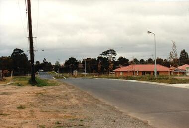
Photograph, early 1990s
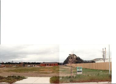
The series of 5 photographs feature different views of the Woodlands Housing Development which opened up land bounded by Gap and Anderson Roads, Cornish Street and Elizabeth Drive in the early 1990s. It was a large housing development built close to Sunbury township.A coloured photograph of one of the last housing developments which took place in the old township area. It is a photograph taken at the north end of Anderson Road looking towards Gap Road. One house has been built and there are a number of 'For Sale' signs of blocks fronting Anderson Road. Guttering and driveways have been formed on one side of the road.housing developments, anderson road, george evans collection -
 Hume City Civic Collection
Photograph, early 1990s
The series of 5 photographs feature different views of the Woodlands housing development which opened up land bounded by Gap and Anderson Roads, Cornish Street and Elizabeth Drive in the early 1990s. It was a large housing development built close to Sunbury township.A view of the northern boundary of the Woodlands housing development in Anderson Road. A paling fence divides the estate from the 'Malley' factory, now 'Storage King' which is on the corner of Cornish Street and Anderson Road. A 'For Sale' sign is in the foreground and a partly built house is in the middle distance.housing developments, anderson road, george evans collection -
 Old Colonists' Association of Ballarat Inc.
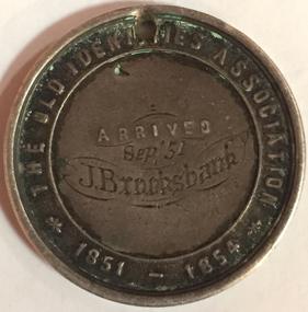
Photograph - Photograph - Colour, John Brooksbank's Old Identities' medal
The Old Identities' Association was a forerunner of the Old Colonists' Association Ballarat. John Brooksbank was a very early arrival to Ballarat in September 1851, which was not long after the discovery of gold at Ballarat. J. Brooksbank lost a dog in 1857 "LOST from the Half Way House, Smythe's Creek Road, a black bloodhound and kangaroo dog. Anyone detaining him after this date will be prosecuted. J. BROOKSBANK" (Ballarat Star, 30 December 1857) Another very early identity in Ballarat, James Oddie, advertised the sale of J. Brooksbank's hotel in 1860: "JAMES ODDIE & CO. have received instructions from the Mortgagees, to sell I by auction at their rooms, Dana street, on Thursday, 20th September, at twelve o'clock, All that desirable properly known as the , Halfway House Hotel, Together with all that piece or parcel of ' land situate in the parish of Cardigan and county of Grenville, containing 34 acres 1 rood 26 ½ perches, part of allotment 1, section 6, of said parish, situated on the Ballarat and Smythesdale road, and recently occupied by Mr J. Brooksbank. The property consists of a spacious stone building one story high, strong and substantially built, the internal fittings and arrangements are neat and complete. The house possesses all requisite accommodation for a respectable country hotel. In addition are stockyards, stables &c, all well and securely fenced. Terms at Sale. (Ballarat Star, 20 September 1860) Four years later Brookbank was selling his hotel in Lyons Street Ballarat: "RARE OPPORTUNITY.-FOR SALE the BLACK BULL HOTEL, Lyons street. The proprietor of the above hotel being about entering into another line of business, begs to call the attention of parties looking for a safe and profitable investment, the above having undergone thorough repairs, and is now in good working order and doing a fair share of business. The conditions will, be half cash, balance six, nine, and twelve months. Apply, J. Brooksbank, proprietor, on the premises. (Ballarat Star, 22 October 1864)Colour photograph of a sterling silver medal relating to The Old Identities' Association 1851-1854. The medallion, belonging to John Brooksbank, has a drilled hole at the top suggesting it was worn by the owner at some stage in its life. The medal has been engraved: Arrived "Sep 51 J. Brooksbankold identities association, old colonists' association ballarat, c.a. welch, silversmith, numismatics, j. brooksbank, medal -
 Old Colonists' Association of Ballarat Inc.
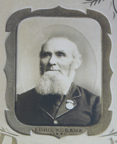
Photograph - Photograph - Black and White, John Brooksbank
The Old Identities' Association was a forerunner of the Old Colonists' Association Ballarat. John Brooksbank was a very early arrival to Ballarat in September 1851, which was not long after the discovery of gold at Ballarat. J. Brooksbank lost a dog in 1857 "LOST from the Half Way House, Smythe's Creek Road, a black bloodhound and kangaroo dog. Anyone detaining him after this date will be prosecuted. J. BROOKSBANK" (Ballarat Star, 30 December 1857) Another very early identity in Ballarat, James Oddie, advertised the sale of J. Brooksbank's hotel in 1860: "JAMES ODDIE & CO. have received instructions from the Mortgagees, to sell I by auction at their rooms, Dana street, on Thursday, 20th September, at twelve o'clock, All that desirable properly known as the , Halfway House Hotel, Together with all that piece or parcel of ' land situate in the parish of Cardigan and county of Grenville, containing 34 acres 1 rood 26 ½ perches, part of allotment 1, section 6, of said parish, situated on the Ballarat and Smythesdale road, and recently occupied by Mr J. Brooksbank. The property consists of a spacious stone building one story high, strong and substantially built, the internal fittings and arrangements are neat and complete. The house possesses all requisite accommodation for a respectable country hotel. In addition are stockyards, stables &c, all well and securely fenced. Terms at Sale. (Ballarat Star, 20 September 1860) Four years later Brookbank was selling his hotel in Lyons Street Ballarat: "RARE OPPORTUNITY.-FOR SALE the BLACK BULL HOTEL, Lyons street. The proprietor of the above hotel being about entering into another line of business, begs to call the attention of parties looking for a safe and profitable investment, the above having undergone thorough repairs, and is now in good working order and doing a fair share of business. The conditions will, be half cash, balance six, nine, and twelve months. Apply, J. Brooksbank, proprietor, on the premises. (Ballarat Star, 22 October 1864)Photographic portrait of John Brooksbank from a photographic montage held by the Ballarat Old Colonists' Association.john brooksbank, ballarat old colonists' association, ballarat old colonists' club, old colonists' association -
 Mt Dandenong & District Historical Society Inc.
Photograph
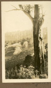
The W. JEEVES in the inscription would be Walter Jeeves. Walter Jeeves was the second son of Ellis Jeeves and the grandson Of Isaac the Pioneer. Walter had been given the house 'Kalorama' and twenty acres of land. He turned this into a commercial garden. Firstly vegetables then later flowers and shrubs. The land was sloping. Walter married Dorothy Hayes and had four daughters. When Walter died in 1960 the property was put up for sale and it was eventually purchased for the State through the efforts of the Save the Dandenongs League. This photograph is from the album of Ivy May Child so would have been taken between 1927 - 1932.Sepia coloured photograh with a tall gum tree in the foreground and a large homestead in the centre of the photograph surrounded by orchards.Written below the photograph in the album: W. JEEVESwalter jeeves, dorothy hayes, save the dandenongs league, kalorama -
 Surrey Hills Historical Society Collection
Photograph, Subdivision sale of Black's Mont Albert farm in 1924, 1924
Photo was taken in 1924 when the land was subdivided. Black's dairy farm occupied the area just east of Hamilton Street to near Elgar Road. It was subdivided into 88 house allotments along Churchill Street, Bruce Street, Black Street, Proudfoot Street and View Street. The solicitors were Proudfoot & Horton, 360 Collins Street; estate agents were Duncan & Weller, 29 Queen Street. The real estate subdivision notice on the SLV website states that Neil Black had been the owner for 50 years. To date no trace of a Neil Black has been found. Box Hill rate books simply give BLACK as the owner in 1877 (no first name); the entry for 1878-1884 states Robert Black. The 1909 electoral roll has entries for Mont Albert Road for Robert Black (farmer), Thomas Black (carter) & Elizabeth Black (HD). The 1912 electoral roll has entries for Mont Albert Road for Robert Black (farmer), Thomas Black (labourer), John Arthur Black (carter) & Elizabeth Black (HD). Robert Black died in 1920 (b. 1836) and is buried in Box Hill Cemetery (CE-*-0057). His parents were John and Margaret Black. He married Lizzie Foley in 1878. She was the daughter of Margaret & John Foley, born in 1859. She died in 1902 aged 43 years and is buried in the same grave, although the cemetery records record her age as 0 years (presumably as no age or date of birth were given at the time of burial). Children: 1. James Hughbert (1880-1954) 2. John Arthur (1881-1959) 3. Alice (1882-1883) - died aged 6 months 4. Laura Elizabeth (1883-1951) 5. Thomas (1885-1965) 6. Isabella (1887-1963) 7. Eleanor (1889-1963) 8. Ada Maud (1890-1968) 9. Robert (1892-1930). BDM Victoria states places of birth as Box Hill, Surrey Hills or Mont Albert. Many of the family are buried in Box Hill Cemetery. None of the girls appear to have married. Communication from a descendant of John Arthur Black gives the following: "John Arthur Black, son of Robert & Lizzie Foley, married Gladys Anne Layton had 4 children, Robert, Elenore, Marion (Follett) & Annie; they had farm on Stud Road, Dandenong where they milked 30 cows that he retired to after being a earth-moving contractor with draft horses and dug irrigation ditches around Shepparton." This is important as documentation of the area's transformation from farming land to residential land use.Black and white photo of a large 3-poled tent in an area of flat land with eucalypts in the background. There is a large crowd of people, mainly men but also women and children. There are also 3 cars to the RHS.black's dairy farm, dairying, farms, churchill street, black street, proudfoot street, bruce street, view street, neil black, proudfoot & horton, duncan & weller, robert black, lizzie black, lizzie foley, james hubert black, john arthur black, alice black, laura elizabeth black, thomas black, isabella black, eleanor black, ada maud black, robert black jnr, box hill cemetery, land sales -
 Surrey Hills Historical Society Collection
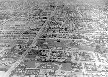
Photograph - Aerial view Riversdale Heights Estate area, c1923
This was probably part of a real estate promotion for the sale of the Riversdale Heights Estate. This was subdivided by Messrs. Duncan and Weller. Of the allotments offered, 30 were sold and realised £4600. Date of this sale was c December 1923. This suggests that the date This are was one of the last pieces of former rural land to be sub-divided for housing in Surrey Hills.The land between it and South Surrey Park was sub-divided post WW1, hence the naming of the streets after sites of WW1 battles.A black and white reproduction of an aerial photo of the area near the corner of Warragul and Riversdale Roads looking west towards the city. Some features have been identified by name including the Riversdale Heights Estate, which was being sub-divided. North and South Courts are shown. Other roads (unmarked) in the foreground are Graham Street, Allie Street, Thistle Street, Lille Street, Amiens Street, and Marne Street. Beyond these is the area marked 'PARK' (South Surrey Park), which is devoid of vegetation. Areas of Camberwell and Canterbury are also shown. The area covered extends to beyond St Dominic's Church. The original is mounted on a cream deckle-edged paper.Beneath the original on the mount: "SOUTH SURREY HILLS LOOKING WEST c. 1936" [The reference to the sale in the Box Hill Reporter of December 1923 found on Trove suggests that this date is not accurate.] Rear top LH corner of original in Jocelyn Hall's handwriting: "For Centre / from Mr James Long"riversdale heights estate, riversdale road, allie street, south surrey park, lille street, thistle street, amiens street, marne street, south court, north court, duncan and weller, real estate sales, graham street, st dominics church, highfield park, canterbury primary school, aerial photo -
 Surrey Hills Historical Society Collection
Photograph, Philip Warren-Smith at J&V Warren-Smith Auto Service, 1991
The land along the eastern side of the Union Road shops between Montrose Street and the railway line was originally owned by the Zeplin family. It was subdivided in 1914 and offered for sale as individual sites. Building did not occur until after WW1 and after the creek across Union Road had been barrelled. The garage was built at 145 Union Road in 1925. It has had continuous use as a garage since then. Originally there were petrol bowsers on the footpath. The façade of the building is remarkably the same as it was in 1925 when David Denholm was the first proprietor. He remained until c1950 and was followed by Benchley Motors P/L, then Spenden Motors P/L. John and Val Warren-Smith purchased it in c1980. In 2019 their family, including Philip and Glenn Warren-Smith and 2 of Philip's sons, still operate it as J&V Warren-Smith Auto Service.The Union Road shopping strip was assessed for heritage protection by Lovell Chen in June 2011 (Surrey Hills and Canterbury Hill Estate Heritage Study: Union Road Commercial Precinct Citation). Within this report two buildings were mentioned as, unusually, still performing their original role. These were Dartnell’s Pharmacy at 376-378 Canterbury Road (contributory) and the motor garage at 145 Union Road (contributory). This is one of a number of 3 images taken in 1991 which document the interior and function of the building.A colour photo of a man in green overalls inside the workshop of a garage. There are two cars up on hoists and three towards the back of the workshop.philip warren-smith, val warren-smith, john warren-smith, j&v warren-smith auto service, benchley motors p/l, spenden motors p/l, garages, union road, businesses, glenn warren-smith, cars -
 Surrey Hills Historical Society Collection
Photograph - Black and White Photograph, J & V Warren-Smith Auto Service, 1991
The land along the eastern side of the Union Road shops between Montrose Street and the railway line was originally owned by the Zeplin family. It was subdivided in 1914 and offered for sale as individual sites. Building did not occur until after WW1 and after the creek across Union Road had been barrelled. The garage was built at 145 Union Road in 1925. It has had continuous use as a garage since then. Originally there were petrol bowsers on the footpath. The façade of the building is remarkably the same as it was in 1925 when David Denholm was the first proprietor. He remained until c1950 and was followed by Benchley Motors P/L, then Spenden Motors P/L. John and Val Warren-Smith purchased it in c1980. In 2019 their family, including Philip and Glenn Warren-Smith and 2 of Philip's sons, still operate it as J&V Warren-Smith Auto Service.The Union Road shopping strip was assessed for heritage protection by Lovell Chen in June 2011 (Surrey Hills and Canterbury Hill Estate Heritage Study: Union Road Commercial Precinct Citation). Within this report two buildings were mentioned as, unusually, still performing their original role. These were Dartnell’s Pharmacy at 376-378 Canterbury Road (contributory) and the motor garage at 145 Union Road (contributory). This is one of a number of 3 images taken in 1991 which document the interior and function of the building.A colour photo of a man in green overalls working on a car with its bonnet up.john warren-smith, val warren-smith, philip warren-smith, glenn warren-smith, j&v warren-smith auto, union road, businesses, garages, cars, mechanics -
 Surrey Hills Historical Society Collection
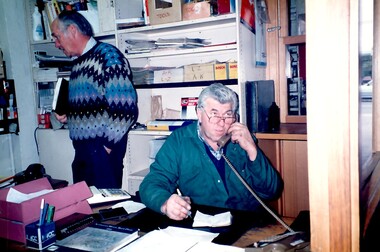
Photograph, Wally Hoersch of J&V Warren-Smith Auto, 1991
The land along the eastern side of the Union Road shops between Montrose Street and the railway line was originally owned by the Zeplin family. It was subdivided in 1914 and offered for sale as individual sites. Building did not occur until after WW1 and after the creek across Union Road had been barrelled. The photo was taken in the office of the garage which was built at 145 Union Road in 1925. It has had continuous use as a garage since then. Originally there were petrol bowsers on the footpath. The façade of the building is remarkably the same as it was in 1925 when David Denholm was the first proprietor. He remained until c1950 and was followed by Benchley Motors P/L, then Spenden Motors P/L. John and Val Warren-Smith purchased it in c1980. In 2019 their family, including Philip and Glenn Warren-Smith and 2 of Philip's sons, still operate it as J&V Warren-Smith Auto Service. The man on the phone is Walter Kurt (Wally) Hoersch. Warmly regarded and often mistakenly thought to be Philip's father, he was not a member of the family. Wally had an interesting background, not known to many. He was born in the German Templer colony of Sarona in Palestine. It had been established in Ottoman Palestine in 1871 and is now a suburb of Tel Aviv. In July 1941, 188 people from Sarona were deported to Australia on the Queen Elizabeth. Wally's family were amongst them. They were interned in Tatura in Central Victoria until 1947. Wally lived in Mont Albert North and later Templestowe; he died on 21/7/2002.The Union Road shopping strip was assessed for heritage protection by Lovell Chen in June 2011 (Surrey Hills and Canterbury Hill Estate Heritage Study: Union Road Commercial Precinct Citation). Within this report two buildings were mentioned as, unusually, still performing their original role. These were Dartnell’s Pharmacy at 376-378 Canterbury Road (contributory) and the motor garage at 145 Union Road (contributory). This is one of a number of 3 images taken in 1991 which document the interior and function of the building.A colour photo of a man sitting behind a desk in an office on the phone. There is another man standing behind him to his right.john warren-smith, val warren-smith, philip warren-smith, glenn warren-smith, walter hoersch, wally hoersch, j&v warren-smith auto, union road, businesses, garages, benchley motors p/l, spenden motors p/l, -
 8th/13th Victorian Mounted Rifles Regimental Collection
Photograph
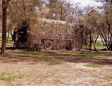
Exercise of this type aimed to practice driver skills, map reading, camouflage and concealment. The 8th/13th Victorian Mounted Rifles was raised as a regiment of the Royal Australian Armoured Corps on 1 May 1948 with Headquarters in Melbourne and squadrons in Sale, Benalla/Wangaratta and Albury. In 1955 Regimental Headquarters moved to Wangaratta and a second squadron was located at Albury. The Sale squadron transferred to 4th/19th Prince of Wales’s Light Horse. In 1977 8/13 VMR Regiment was reduced to an independent squadron A Squadron 8th/13th Victorian Mounted Rifles and in 1991 was linked with 4th/19th Prince of Wales’s Light Horse forming the VMR Squadron of that regiment.Colour photograph of truck in scrub-land covered with camouflage net,during " B " vehicle exercise in south west Victoria conducted by 8/13 Victorian Mounted Rifles, c. 1986. -
 8th/13th Victorian Mounted Rifles Regimental Collection
Photograph
This exercise was conducted by A Squadron 8/13 Victorian Mounted Rifles using Land rovers and trucks. The 8th/13th Victorian Mounted Rifles was raised as a regiment of the Royal Australian Armoured Corps on 1 May 1948 with Headquarters in Melbourne and squadrons in Sale, Benalla/Wangaratta and Albury. In 1955 Regimental Headquarters moved to Wangaratta and a second squadron was located at Albury. The Sale squadron transferred to 4th/19th Prince of Wales’s Light Horse. In 1977 8/13 VMR Regiment was reduced to an independent squadron A Squadron 8th/13th Victorian Mounted Rifles and in 1991 was linked with 4th/19th Prince of Wales’s Light Horse forming the VMR Squadron of that regiment.Colour photograph of convoy of vehicles entering Warrnambool Victoria during 8/13 Victorian Mounted Rifles annual exercise, 1985 -
 Kew Historical Society Inc
Plan - Subdivision Plan, H C Crouch, Old Golf Links Estate, 1930s
The land in North Kew between the Outer Circle Railway and the River Yarra was released in sections. This release included 80 lots. Most of this area was released during the Depression years in the early 1930s.Subdivision plans are historically important documents used as evidence of the growth of suburbs in Australia. They frequently provide information about when the land was sold on which a built structure was subsequently constructed as well as evidence relating to surveyors and real estate and financial agents. The numerous subdivision plans in the Kew Historical Society's collection represent working documents, ranging from the initial sketches made in planning a subdivision to printed plans on which auctioneers or agents listed the prices for which individual lots were sold. In a number of cases, the reverse of a subdivision plan in the collection includes a photograph of a house that was also for sale by the agent. These photographs provide significant heritage information relating house design and decoration, fencing and household gardens.One part of a massive subdivision of the Old Golf Links Estate in North Kew of 80 allotments bordering Sutherland Avenue, Ramsay Avenue, Belford Road, Beresford Street and Coleman Avenue. Inset on the plan at the top left, the route of the Outer Circle Railway is clearly marked. The Kew Golf Links is identified in its current location. The land on which Greenacres Golf Club was to be constructed is at this time marked as ‘Recreation Ground’. The ‘new bridge’ over the Yarra at Burke Road is also marked on the inset map. The Plan identifies the surveyor (sic) H.C. Crouch BCE MVIS, 443 Little Collins St., Melbourne. The date of the subdivision auction sale in identified as Saturday September 25th at three o'clock.Annotations: "E" top left. "Golf Links" top right. Lots 73-76 ticked and listed as "6" poundssubdivisions -- kew (vic.), old golf links estate -
 Kew Historical Society Inc
Photograph - Cosy Five Roomed Rough Cast Bungalow, Kew, J E Barnes, c.1920
Subdivision plans are historically important documents used as evidence of the growth of suburbs in Australia. They frequently provide information about when the land was sold on which a built structure was subsequently constructed as well as evidence relating to surveyors and real estate and financial agents. The numerous subdivision plans in the Kew Historical Society's collection represent working documents, ranging from the initial sketches made in planning a subdivision to printed plans on which auctioneers or agents listed the prices for which individual lots were sold. In a number of cases, the reverse of a subdivision plan in the collection includes a photograph of a house that was also for sale by the agent. These photographs provide significant heritage information relating house design and decoration, fencing and household gardens. The photograph is also aesthetically significant as it was taken by J. E. Barnes, a nationally significant photographer. He was the most important photographer to have worked in Kew. He was active as a photographer in the district from c.1906 until his death in 1921. Best known as 'the Embarkation Photographer' (see the Australian War Memorial collection), Josiah Earl Barnes was also the official photographer employed by the Borough (and later Town, then City) of Kew. He clearly also completed commercial jobs for local businesses, as is the case in this photograph of a house for a local real estate and financial agent. A modest weatherboard house with rough-cast rendered walls. The gabled entrance incorporates elements of the Japanese aesthetic. The strong lines of the dark timber gable are reinforced by the colour and shape of the pickets in the fence. In contrast to an earlier period, the chimneys appear truncated. The use of extensive double-hung sash windows in the front rooms reflects a new interest in light in houses. The use of separate sunshades over windows in an earlier period is here replaced by an extension of the roofline over the window. The photographer Josiah Barnes died in 1921; so, the photograph of the house must predate this date. The location of the house, which was advertised for sale, has to date not been identified. Illegible inscription. Photographer's information on mount.josiah earl barnes, j e barnes, photography - kew, interwar housing - victoria, 1920s housing - kew -
 Kew Historical Society Inc
Photograph - 2 Young Street, Kew, Paramount Photos, 1920s
Subdivision plans are historically important documents used as evidence of the growth of suburbs in Australia. They frequently provide information about when the land was sold on which a built structure was subsequently constructed as well as evidence relating to surveyors and real estate and financial agents. The numerous subdivision plans in the Kew Historical Society's collection represent working documents, ranging from the initial sketches made in planning a subdivision to printed plans on which auctioneers or agents listed the prices for which individual lots were sold. In a number of cases, the reverse of a subdivision plan in the collection includes a photograph of a house that was also for sale by the agent. These photographs provide significant heritage information relating house design and decoration, fencing and household gardens.A prepossessing, large home constructed in the Arts and Crafts style. Located on the banks of the Yarra at 2 Young Street, Kew overlooking the factories of Richmond, the design of the house takes account of the gradient with the addition of a level below the front entrance. The elegant roof includes a number of projecting gables and dormers. The gables are typically half-timbered and rendered. In addition to the asymmetrically placed portico, there are at least two open verandas, supported by timber pillars and with roofs that reflect the overall pitch of the roof of the housereal estate photographs, 2 young street - kew