Showing 2472 items matching " township"
-
 Federation University Historical Collection
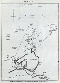
Image, Batman's Map of Port Phillip
Scanned from "The Old Pioneers' Memorial History of Melbourne From the Discovery of Port Phillip to the World War". It is a facsimile map from the House of Commons Reports of Committee.John Batman's map of Port Phillip showing Dutigalla (Batman's Tract), a township reserve, open plains, public common reserve, fresh water"A tract of country [called?] by the native chief of Southern Ausralia to be John Batman 6th June 1935."port phillip bay, john batman, melbourne, iramoo, r. sarsh, river sarsh, river batman, yarra river -
 Clunes Museum
Negative - NEGATIVES, Mar-00
COLLECTION OF NEGATIVES -CLUNES TOWN HALL & COURT HOUSE, CLUNES HOSPITAL, CLUNES IN THE 60S, TOWNSHIP OF CLUNES FROM THE ROCKS , BUTTER FACTORY CLUNES.CLUNES BOROUGH COUNCIL ELECTED COUNCILLOR 28/8/1930.MAYOR 1934-35. HORNSBY STUDIO BALLARAT.photography, photography, negatives -
 Southern Sherbrooke Historical Society Inc.
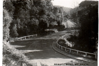
Postcard - Postcard-original-Beauty Bend, Belgrave, Vic. c. early 1930s, Beauty Bend
Sepia-toned postcard featuring Beauty Bend just outside Belgrave Township on Monbulk Road. There is heavy bush to either side. A house is in the distance. -
 Wodonga & District Historical Society Inc
Album - Hume Reservoir Australia Album - Workmen's Dwellings during Hume Reservoir construction, Department of Public Works, N.S.W, C. 1927
This set of photos is from a leather bound album bearing the inscription "HUME RESERVOIR AUSTRALIA" plus 'The Rt. Hon. L. C. M. S. Amery, P. C., M .P.' all inscribed in gold. It was presented to The Rt. Hon. L. C. M. S. Amery, P. C., M. P, Secretary of State for Dominion Affairs on the occasion of his visit to the Hume Reservoir on 2nd November 1927. This album is of local and national significance as it documents the planning and development of the Hume Reservoir up to 1927. It was the largest water reservoir in the British Empire. The album records the pioneering engineering work that went into its construction.DEPARTMENT OF PUBLIC WORKS, N.S.W. RIVER MURRAY WATERS SCHEME. HUME RESERVOIR. 8. Types of Workmen's Dwellings in the New South Wales Township. hume reservoir australia, river murray waters scheme, workmen's dwellings hume -
 Wodonga & District Historical Society Inc
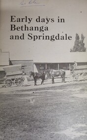
Book - Early Days in Bethanga and Springdale, June Philipp, April 1977
This publication was produced for the Bethanga-Springdale Schools Centenary Committee to mark the centenary of the Bethanga State School and the closing of the school at Springdale. It traces settlement in the area from the arrival of early pastoralists c1835 followed by the free selectors and later the miners. The remainder of the publication focuses on the establishment of the Bethanga and Springdale Schools and a brief outline of pioneer families of the Bethanga area.A small book of 99 pages including text, sketch maps and images telling the story of the early settlement of Bethanga and Springdale townships in Northeast Victoria.non-fictionThis publication was produced for the Bethanga-Springdale Schools Centenary Committee to mark the centenary of the Bethanga State School and the closing of the school at Springdale. It traces settlement in the area from the arrival of early pastoralists c1835 followed by the free selectors and later the miners. The remainder of the publication focuses on the establishment of the Bethanga and Springdale Schools and a brief outline of pioneer families of the Bethanga area.bethanga history, springdale history -
 Clunes Museum
Postcard - PHOTOGRAPH, PRINTED IN GERMANY, CLUNES FROM THE ROCKS
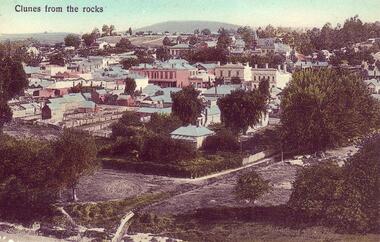
COLOURED POSTCARD OF VIEW OF CLUNES - TAKEN FROM THE ROCKS CLUNES FROM THE ROCKS. COLOURED COPY OF PHOTOGRAPH OF CLUNES TOWNSHIP, SHOWING BANKS AND PUBLIC BUILDINGS IN FRASER STREET. PRINTED AS A POSTCARD. 4 COPIES759.2. DEAR ROD. WITH BEST LOVE TO YOU ALL FOR A MERRY XMAS AND A BRIGHT NEW YEAR HOPING YOU HAVE A GOOD TIME FROM AUNT MARIA. 759.4. HANDWRITTEN MESSAGES FROM CARLIE AND THELMA WEICKHARDTlocal history, document, postcard, clunes township -
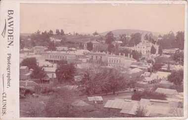
 Clunes Museum
Photograph, BAWDEN PHOTOGRAPHER, CIRCA 1890
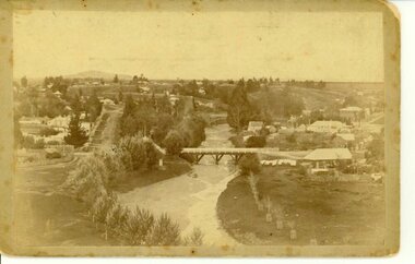
TULLAROOP CREEK FROM "ROCKS" NEAR SITE OF PORT PHILLIP MINE. ABOUT 1890 - NOTE GOVERNMENT BRIDGE IN DISTANCE. THIS WAS REBUILT IN STRAIGHT STEEL GIRDERS IN 1896.ORIGINAL SEPIA PHOTOGRAPH OF TULLAROOP CREEK, IN FOREGROUND VIEWS OF CLUNES TOWNSHIP. TWO MILE HILL IN LEFT FAR DISTANCE. (SUSPENSION BRIDGE IN FOREGROUND)local history, photography, bridges - buildings and landscape of clunes -
Clunes Museum
Photograph, KODAK, 1999
VIEW OF POWDER MAGAZINE USED IN MINING DAYS TO STORE EXPLOSIVES. BUILDING MATERIALS SOLID BRICKCOLOURED PRINT PHOTOGRAPH OF POWDER MAGAZINE INTERIOR. SITUATED IN A PADDOCK ON SMEATON ROAD APPROX. 2 KM. FROM TOWNSHIP ON LEFT HAND SIDE.local history, photographs, mining, powder magazine -
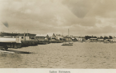
 Lakes Entrance Historical Society
Postcard - Westerson, 1908
Message on reverse: From Mabel at Tarnagulla to Zilpah Westerson at Clifcrest CunninghameBlack and white postcard showing buildings around shore line, ferry docked at business wharf , steam train around bay , township in distancecorrespondence, genealogy -
 Bacchus Marsh & District Historical Society
Map, Plan of the property of Messers Atkins and Clarke to be sold at the Mansion, Bacchus Marsh 19th April 1856. Copy 1
This plan of land allotments for sale indicates the property once owned by the Bacchus family in and around the township area of Bacchus Marsh. The Bacchus family sold their property in Bacchus Marsh to John Atkins and Robert Nalder Clarke in March 1851. Atkins and Clarke kept the property for a number of years until April 1856 when these allotments were put up for sale.This plan is almost identical to another copy held by the Bacchus Marsh and District Historical Society, VC Record 452, BMDHS collection). This plan, VC Record 707 Copy 1, contains a little more detail overall than VC Record 452 Copy 2, such as who did the survey work for the plan (R.C. Bagot) and who the selling agents were, (W.M. Tennent), and on the right side of the plan near the Lerderderg River is indicated the general area for a second parcel of land from this sale which is to be sold. There is also a compass illustration indicating north and south compass points.This is a very early land sales plan for the township of Bacchus Marsh and it therefore provides some clues as to how the early urban development of the township took place. Upon seeing the map in 1911 Bacchus Marsh Express newspaper editor Christopher Crisp wrote "The sale appears to have created the present township, which had a nucleus in earlier times further east", Express, 30 September, 1911, page 3.A single page paper plan showing allotments of land for sale. The subdivided land shown was owned by John Atkins and Robert Nalder Clarke, but previously owned by the Bacchus Family and was in and around their Manor House (Mansion) property in Bacchus Marsh.There are 5 portions of land further divided into numerous small portions. The land for sale is bounded by the present day streets of Main Street, Young Street, McFarland Street, Morton Streets, Crook Street, and part of the eastern section extends to the Lerderderg River. Scale: 8 chains to 1 inch The plan is pasted into a bound volume containing 76 maps or plans in total. BMDHS Loc: AR/B12/S4 Bacchus Marsh Township and Nearby Districts Maps Volume In-house Digital copies: BMDHS, Computer Network: Maps\Bacchus Marsh Township and Nearby Districts Maps VolumeHeading: Plan of the first portion of land. The property of Messers Atkins and Clarke situate at Bacchus Marsh. To be sold by W.M. Tennent & Co. at the Mansion on the Ground on Saturday the 19th April 1856. Below heading: Jas Ferguson, Lithographer On upper right side: Subdivided by R.C. Bagot London and Liverpool Chambers, Melbourne. 'Thos Taubman'. Post Office Stamp: BACCHUS MARSH VICTORIA MY 6, 63bacchus marsh victoria maps, bacchus family, land sales, manor house bacchus marsh -
 Ringwood and District Historical Society
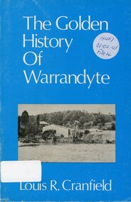
Book, The Golden History of Warrandyte - Louis R. Cranfield
History of more than a 100 years from the earliest days of the discovery of gold and the setting up of a mining camp through to the transition of becoming a thriving township -
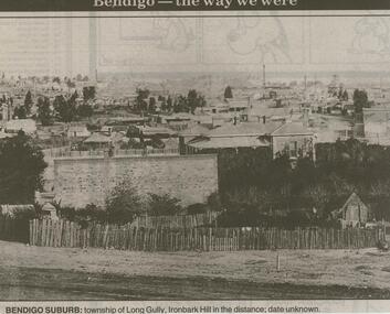 Bendigo Historical Society Inc.
Newspaper - JENNY FOLEY COLLECTION: BENDIGO SUBURB
Bendigo Advertiser ''The way we were'' from 2000. Bendigo suburb: township of Long Gully, Ironbark Hill in the distance; date unknown. The clip is in a folder.newspaper, bendigo advertiser, the way we were -
Tatura Irrigation & Wartime Camps Museum
Book, Warwick Finlay, The Doctor, The Captain, The Poet and Others, 2004
This book was printed to commemorate the 150th Anniversary of the survey, naming of the town and sale of land at Murchison.Black and white cover featuring the Goulburn River and portraits of Doctor McMillan, Captain John Murchison and Orion Horne over and early plan of Murchison Townshipmurchison -
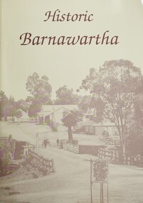 Wodonga & District Historical Society Inc
Book - Historic Barnawartha, Barnawartha History Book Committee, 1992
This publication was created by a local history group at Barnawartha, Victoria to update an earlier publication and document the local history of their community. It includes information about early homesteads, the Barnawartha Primary School and other community institutions. An 1899 map of the parish of Barnawartha is included.A4 sized publication of 70 pages, including maps and illustrations. Beige coloured cover features an image of the main street of Barnawartha township prior to 1900.non-fictionThis publication was created by a local history group at Barnawartha, Victoria to update an earlier publication and document the local history of their community. It includes information about early homesteads, the Barnawartha Primary School and other community institutions. An 1899 map of the parish of Barnawartha is included.barnawartha, barnawartha primary school -
Clunes Museum
Document - HISTORY TALBOT TOWNSHIP, 1970
.1 HISTORY OF TALBOT TOWNSHIP 1852 .2 PORTION OF LIST OF CLUNES BUILDINGS, CHURCHES, HOSPITAL, RAILWAY STATION ETC. COMPILED BY CONRAD WEICKHARDT 1970local history, document, talbot, history, history of talbot & clunes -
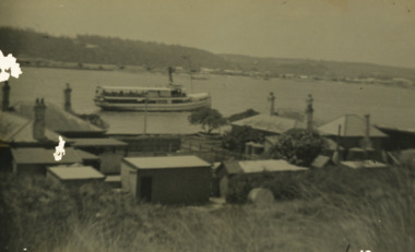 Lakes Entrance Historical Society
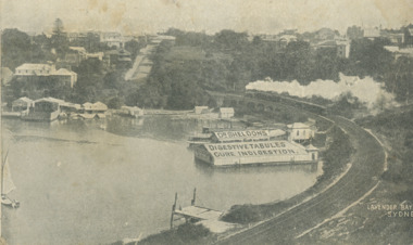
Postcard - S.S. Gippsland, 1915 c
Black and white postcard showing SS Gippsland in Cunninghame Arm opposite New Works houses and works buildings with township in background Lakes Entrance Victoriaships and shipping, jetties -
 Clunes Museum
Photograph, BAWDEN PHOTOGRAPHER
SEPIA POSTCARD / PHOTOGRAPH - OVERVIEW OF CLUNES TOWNSHIP. S.S. BANK. CLUB HOTEL, POST OFFICE, TOWNHALL, WESLEY CHURCH AND TWO MILE HILL IN BACKGROUND.TO WISH YOU ALL GOOD CHRISTMAS BLESSINGS AND A HAPPY NEW YEAR. J. PATIENCE DEC. 1907.local history, photography, photographs, clunes township -
 Lakes Entrance Historical Society
Postcard, H D Bulmer, Houses on Esplanade Lakes Entrance c1922, 1922
Houses fronting Esplanade Lakes EntranceBlack and white postcard of western end of township showing front lake and buildings on Esplanade with boat on slipway left side of image, Lakes Entrance VictoriaLakes Entranceboats and boating, waterways, gippsland lakes, houses -
Clunes Museum
Map, CHARLES FENTON, 1987
TRANSPARENT PLASTIC SHEET WITH A MAP OF CLUNES TOWNSHIP DRAWN IN BLACK WITH TINY WHITE STICKERS DENOTING POINTS OF INTEREST, MOUNTED TO BROWN PAPER AND PINNED IN PLACE ON REVERSE OF BROWN PAPER WRITTEN IN BLACK IN "CLUNES 1987 TRACINGS"clunes 1987, clunes township map -
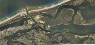 Lakes Entrance Historical Society
Photograph - Lakes Entrance, Gippsland Ports, 2006 c
Colour aerial photograph showing view of entrance to Gippsland Lakes from Bass Strait Reeves Channel Rigby Island and township of Lakes Entrance Victoriaaerial photograph, historic site, dredging, waterways, lakes entrance -
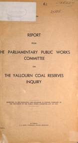 Ballarat Tramway Museum
Document - Report, Parliament of Victoria, "The Yallourn coal reserves", May 1971
Report looked into the future of the Yallourn Township. Has a brief history of the location, the SEC power generation and its relationship the history of Vitoria. Lists the parliamentary inquiry board members, the witnesses, a table of the community organisations based at Yallourn township, coal reserves and costs. The Parliamentary Committee recommended that the SEC proposal be followed, that is close the township and mine the coal reserves that were under the township. Dated May 1971.Yallourn and other mines provided the brown coal for Ballarat B Power station and power Ballarat's tramways.Foolscap report - 6 sheets + 3 folded sheets, stapled on the left hand side and bound with black tape.Has the markings of the State Transport Library.yallourn, secv, brown coal, power supply, power engineering -
Lakes Entrance Historical Society
Book, Copeland Hugh, The Path Of Progress Shire of Warragul 1934, 1934
A history of the Shire of Warragul Victoria. This book is a valuable reference because of the era in which it was written.township -
Lakes Entrance Historical Society
Book, Clements, Eddie and Shepherd, Keith White, Lee, Around the Campfire Ashes. Tales of Old Gippsland, 1986
Stories of people and places of East Gippsland, as recalled by two men who spent schooldays at Bruthen, and many years camping in the bush and enjoying the company of local residents.Ruth Clarktownship -
Lakes Entrance Historical Society
Book, Smyth Chris, Baltuiks Isabel, Roberts Lorelle, Roberts Maurice, Stooping Stones a Guide to Mallacoota and District, 1986
Description guide to Mallacoota Victoria and the surrounding district of far East Gippsland including Genoa Gipsy Point and Betka River illustrated with sketch maps photographs and sketches.township -
Lakes Entrance Historical Society
Book, Butler, Graeme, Port Albert, 1982
A study of the buildings and historical sites of the Alberton Shire, Victoria. Illustrated with photograps and diagrams.township -
Lakes Entrance Historical Society
Book, East Gippsland Historical Society, Some Historic Buildings in Bairnsdale, 1979
A short history of Bairnsdale Victoria with descriptions of some of the more noteable older buildings.township -
 Lakes Entrance Historical Society
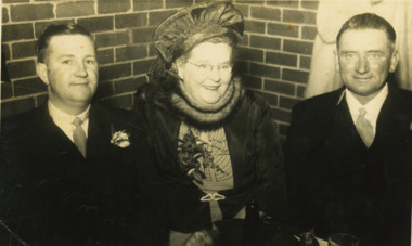
Postcard - Fallshaw nee Roadknight, Nancy Studio Bankstown NSW, 1950 c
Black and white postcard of Mrs Pearl Fallshaw nee Roadknight with son Malcolm and another unidenified man Bankstown NSWtownship -
 Lakes Entrance Historical Society
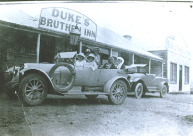
Photograph - Dukes Bruthen Inn , Bruthen Victoria, 1922
Black and white photograph of Dukes Bruthen Inn with two cars in front, 1920's models, one with six ladies on board, spare tyer on running board. Bruthen Victoria. Also an enlarged copy.township -
 Lakes Entrance Historical Society
Postcard, Bruthen Cottage Hospital Main Street Bruthen Victoria, 1910 c
Sepia toned postcard of early Bruthen showing main street going left to right with Commercial bank seen in centre Bruthen Victoria. Also black and white enlargedment.1township -
Bendigo Historical Society Inc.
Map - CAMPBELL COLLECTION: BENDIGO AND DISTRICT MAPS, 21-8-1972
Map. Shire of Strathfieldsaye Locality Plan. Scale 1 inch=1 mile. Drawn by M.Higgs 21-8-1972, Shire of Huntly, Shire of McIvor, City of Bendigo, Shire of Marong, Shire of Maldon, Shire of Metcalfe, Lake Eppalock, Axedale Township, Strathfieldsaye Township, Melbourne to Bendigo Railway Line, Big Hill Tunnel, Mt.Herbert 1596. (number 398 in map cupboard 1)M.Higgs 21-8-1972map, bendigo, locality plan