Showing 15008 items matching " view"
-
 Federation University Historical Collection
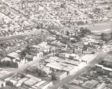
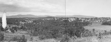
Photograph - Photograph - Black and White, Aerial View of Federation University SMB Campus, c1967
This photograph was taken around the time that the Ballarat School of Mines obtained the Former Ballarat Gaol site and the Ballarat Brewery site.Black and white photograph showing an aerial View of Federation University SMB Campus. The image shows the former Ballarat Gaol (now demolished), Ballarat Brewery, (now demolished) and White Flat Oval.ballarat school of mines, ballarat gaol, ballarat brewery, white flat, ballarat townscape, smb campus, ballarat school of mines campus, lydiard street, aerial -
 Mt Dandenong & District Historical Society Inc.
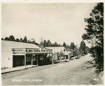
Photograph, Street View, Olinda, late 1930s
Number 1 in commercial series.Small photograph, number 1 in Olinda series, showing a view of the Main Street of Olinda late 1930s. V.J. Boulter's Olinda General Store with butcher and bakery in foreground. Road not yet made.boulter, v.j. boulter, general store, butcher, bakery, olinda -
 Linton and District Historical Society Inc
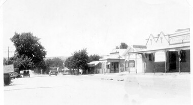
Photograph, Sussex Street, Linton - view to north, late 1920s or early 1930s
Dated to late 1920s or early 1930s as Nelson building has been renovated as a Californian bungalow. The earlier curvilinear parapet on the library building (see photo - Registration no. 166) has been squared off, and a small pedimented timber parapet has been added above.Black and white photograph of Linton's main street, Sussex Street. View of Railway Hotel, Nelson undertaker building, public library and "cash emporium". Cars parked and driving along Sussex St."Linton Main Street".sussex street linton, railway hotel, nelson undertakers, linton public library, cash emporium, transport, cars -
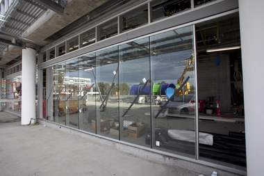
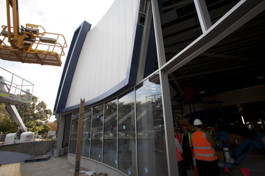
![Photograph - Digital image, Watermarc under construction: View of building exterior [worksite], 18/05/2012](/media/collectors/4f729f5697f83e03086015b8/items/54c878a72163100b58415a84/item-media/54c878dc2163100b58419536/item-fit-380x285.jpg) Greensborough Historical Society
Greensborough Historical SocietyPhotograph - Digital image, Watermarc under construction: View of building exterior [worksite], 18/05/2012
View of building exterior [worksite]. The redevelopment of the Greensborough Pool into the Watermarc aquatic centre is documented in this collection of photographs from the collection of Rosie Bray. These photographs taken on a ‘Community Consultative Committee’ walkthrough prior to completion of Watermarc, May 18 2012.Digital copy of colour photograph.watermarc, rosalie bray, greensborough swimming pool, swimming pools -
 Greensborough Historical Society
Photograph - Digital image, Watermarc under construction: View of windows with reflection of waterslide, 18/05/2012
View of windows with reflection of waterslide. The redevelopment of the Greensborough Pool into the Watermarc aquatic centre is documented in this collection of photographs from the collection of Rosie Bray. These photographs taken on a ‘Community Consultative Committee’ walkthrough prior to completion of Watermarc, May 18 2012.Digital copy of colour photograph.watermarc, rosalie bray, greensborough swimming pool, swimming pools -
 Greensborough Historical Society
Photograph - Digital image, View of Bicton Street from Gladstone Road, 1950_
This view of Bicton Street Greensborough, taken from Gladstone Road Briar Hill circa 1950 shows the rural nature of the suburb at this time.Digital copy of black and white photo.bicton street greensborough, gladstone road briar hill -
 Glenelg Shire Council Cultural Collection
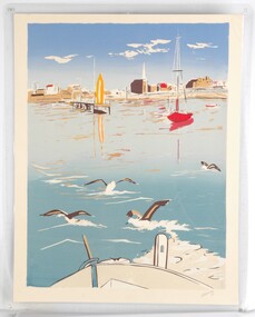
Print, View From A Boat, 1984
Laminated screenprint of Portland harbour from the perspective of a boat looking back towards the shore. In the foreground is the front of the boat and four birds about to take flight from the water. The background features a few boats and the buildings along Bentinck Street. -
 Greensborough Historical Society
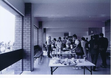
Photograph - Photograph - Digital Image, Opening of Shire of Diamond Valley offices 1972: Interior view of refreshments being served, 26/02/1972
The official opening of the Shire of Diamond Valley offices in Greensborough on 26/02/1972. This photograph shows an interior view of refreshments being served.Photographs taken by a member of SDV staff.Photographs from of a folder of 21 colour photographsOn cover of folder "Opening of S.D.V. Office"shire of diamond valley, shire of diamond valley offices 1972 -
 Stawell Historical Society Inc
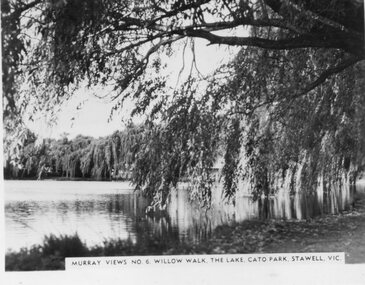
Photograph, Murray Views, "Willow Walk" at the Lake in Cato Park Stawell c1950 -- Postcard, C 1950
Sister of Donor Visited Stawell in th e1950'2 When she Purchased thes Murray Views Cards. The Cards were produced for sale to touristsSet of 8 Murry Views Postcards No 1 to No 8 C. 1950Murray Views No 6 Willow Walk The Lake Cato Park Stawell -
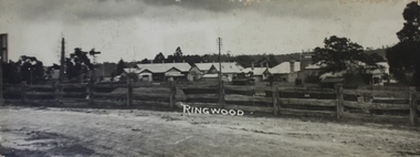
 Ringwood and District Historical Society
Photographs, 1979-80 MMBW pipe line project at Hubbard Reserve, North Ringwood � View towards Debbie Place
Part of a 43-photo record of the MMBW�s engineering feat in drilling a 12 inch pipe line up to 40 feet deep through rock hardened by volcanic action associated with geological fault that occurs along the line. The work took place from October 1979 to May 1980 on the southern boundary of Hubbard Reserve, North Ringwood. The collection was presented to the Ringwood Historical Research Group by J Clarke on 9th June 1980.E561 N15 3 March 1980 A43 View towards Debbie Place, showing 2 swivel cranes at shafts, timber of manhole in creek, the tracked drill rig and its compressor caravan. -
 Ringwood and District Historical Society
Photograph, Panoramic view of Ringwood taken from the home of Dr. Geoffrey A. Cook, Loughnan Rd., Ringwood. (No date)
Written on back of photograph, "Panoramic view of Ringwood taken from the home of Dr. Geoffrey A. Cook, Loughnan Rd., Ringwood. See booklet, 'Welcome to Ringwood' 1948 or 49' - H.J. Pearson Mayor". -
 Eltham District Historical Society Inc
Photograph, Peter Pidgeon, View from Bolton Street, Eltham, 2 Aug. 2022
View looking east from Bolton Street near Brougham Street, Eltham taken from PETStock looking over the industrial area of ElthamBorn Digitaleltham, bolton steet, industry, petstock eltham central, little eltham -
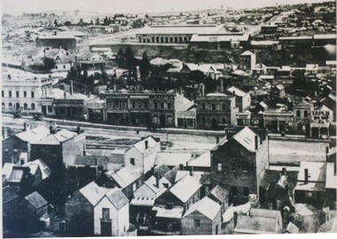
 City of Ballarat Libraries
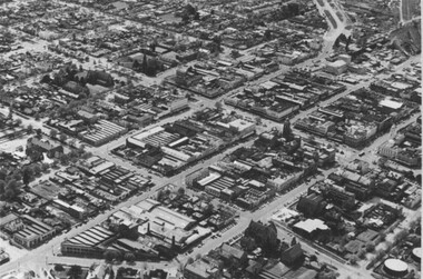
Photograph, Aerial View of the Ballarat CBD in 1957 / 1958
This aerial view of the Ballarat CBC was taken sometime in 1957 or 1958. Sturt Street can be seen running from the right centre to top left.aerial view, sturt street, ballarat, central business district, cbd -
 City of Ballarat Libraries
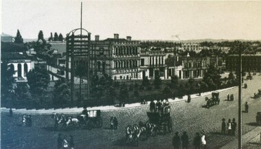
Photograph, View the Unicorn Hotel of Sturt and Camp Streets
The State Bank and Library buildings and telegraph can be seen. This sketch comes from from the Premier Album of Ballarat Views circa 1870-1880.unicorn hotel, state bank, library, building, streetscape, ballarat, telegraph, premier album of ballarat views -
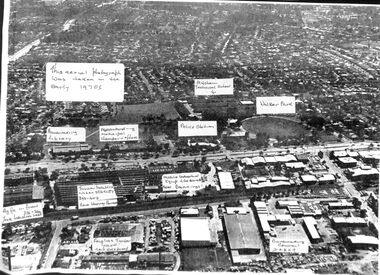
 Stawell Historical Society Inc
Photograph, Stawell Aerial View Centred on Town Hall in Main Street 1998 -- Coloured
Colour Aerial View of Stawell 1998 Centred on Town Hall. Main Street. Scallan Street Childe Street Houston Street and Ligar Street.stawell -
 Greensborough Historical Society
Photograph - Photograph - Digital Image, Opening of Shire of Diamond Valley offices 1972: Exterior view of building and crowd, 26/02/1972
The official opening of the Shire of Diamond Valley offices in Greensborough on 26/02/1972. These photographs show an exterior view of the new building and the crowd in attendance.Photographs taken by a member of SDV staff.Photographs from of a folder of 21 colour photographsOn cover of folder "Opening of S.D.V. Office"shire of diamond valley, shire of diamond valley offices 1972 -
 Ringwood and District Historical Society
Photograph, View of buildings on Maroondah Highway, Ringwood, taken overlooking railway yard from Station Street and Greenwood Avenue - 1914
Enlarged copy of smaller archived photograph - view of buildings on Maroondah Hwy taken overlooking railway yard from Station Street and Greenwood Avenue, 1914. Black and white photo on heavy cardboard backing. -
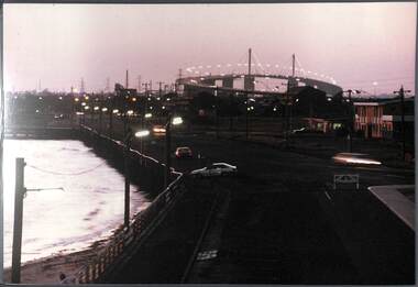 Port Melbourne Historical & Preservation Society
Photograph, James Lauritz, Night time view of Beach St looking West towards West Gate Bridge, 1989 - 1990
Night time view of Beach St looking West towards West Gate Bridge James LAURITZ print of Port Melbourne, laminated (one of 18). Copies of slides produced for Port Melbourne Councilbeach street, local government - city of port melbourne, built environment, james lauritz, engineering - bridges, west gate bridge -
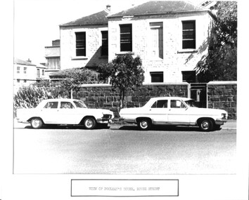 Port Melbourne Historical & Preservation Society
Photograph - House built for Frederick Poolman, Manager, Victorian Sugar Mills, Rouse Street, Port Melbourne, View of Poolman's house, Rouse Street, 1960s
Poolman's house became the manager's house for Harper's when that company took over the area of the former sugar mill. It was demolished late 1970s. Used for Council display purposes and still mounted with caption together with photo of Swallow and Ariell houses.(no.679)Photographic copy of a photo of blue stone two-storey house built for the Manager of the Victorian Sugar MIlls, Frederick POOLMAN. Labelled 'View of Poolman's house, Rouse Street' as part of a display prepared by Council.'131' in blue ink; 'Poolmans house?' in blue inkbuilt environment - industrial, built environment - domestic, frederick poolman, victorian sugar works, colonial sugar refineries -
 Whitehorse Historical Society Inc.
Photograph, View from Mitcham Pedestrian Bridge, 1/07/2000 12:00:00 AM
Coloured view from pedestrian overpass on Whitehorse Road, looking towards Mitcham right (south) side. Cars parked front into gutter in mid ground are parked in front of St Johns Catholic Church.mitcham, whitehorse road -
 Whitehorse Historical Society Inc.
Photograph, Aerial View of Mitcham, C.1925
Large Aerial View of Mitcham showing Railway and South side. In particular, The Australian Tesselated Tile Co. Works and Quarry. Also Monarch Works, better known as Builders' Trade and Roofing Co. and their Quarry.australian tesselated tile co. pty ltd, aerial photographs, monarch pottery, builders trading and roofing co. ltd -
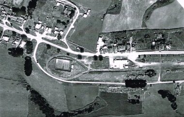 Otway Districts Historical Society
Photograph, R. Preston, Aerial view of Beech Forest railway station and yards, 1965, 13 February 1965
B/W. An aerial view of Beech Forest showing the balloon loop at the end of the station yard (enclosing the two tennis courts), two ex-departmental residences, the station buildings, and other aspects of the township.beech forest: railways; township; aerial; -
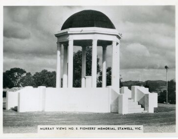 Stawell Historical Society Inc
Postcard, Pioneers’ Memorial on Big Hill
Murray View No. 8. Pioneers’ Memorial photograph showing direction indicators in center of dome installed c 1947 and donated by the Stawell Progress Society. Black and white Murray Views photograph of Pioneers Memorial showing the direction indicator in the center. The direction indicator was given by the Stawell Progress Association in c 1947. Murray Views No. 8. Pioneers' Memorial, Stawell Vic. Rose Seris 12149. Same as Murray Views No 8.stawell -
 Greensborough Historical Society
Photograph - Digital image, Watermarc under construction: Exterior view, windows, 18/05/2012
Watermarc under construction: Exterior view, windows. The redevelopment of the Greensborough Pool into the Watermarc aquatic centre is documented in this collection of photographs from the collection of Rosie Bray. These photographs taken on a ‘Community Consultative Committee’ walkthrough prior to completion of Watermarc, May 18 2012.Digital copy of colour photograph.watermarc, rosalie bray, greensborough swimming pool, swimming pools -
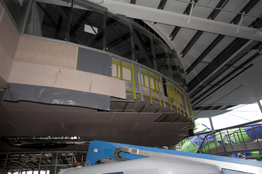 Greensborough Historical Society
Photograph - Digital image, Watermarc under construction: Interior view of mezzanine from ground floor, 18/05/2012
Interior view of mezzanine from ground floor. The redevelopment of the Greensborough Pool into the Watermarc aquatic centre is documented in this collection of photographs from the collection of Rosie Bray. These photographs taken on a ‘Community Consultative Committee’ walkthrough prior to completion of Watermarc, May 18 2012.Digital copy of colour photograph.watermarc, rosalie bray, swimming pools, greensborough swimming pool -
 City of Ballarat Libraries
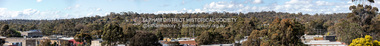
Photograph, Panorama view of Sturt Street circa 1870
This view is from the Post Office tower looking south. Things of interest include the Town Hall, the Burke & Wills Monument, Cobbs Corner and the Mechanics' Institute.panorama, commerical, public, building, gadens, sturt street, streetscape -
 City of Ballarat Libraries
Photograph, View north from Sturt Street circa 1876
This view may have been taken from the Gas Works. Buildings shown include the back of the Mechanics' Institute, Chamber of Commerce and in the distance, Railway sheds.streetscape, oblique view, commerical, building, mechanics institute, chamber of commerce, railway, public -
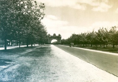 City of Ballarat Libraries
Photograph - Card Box Photographs, View along Sturt Street to the Arch of Victory, circa 1950
View west from Gillies Street along Sturt Street to Arch of Victory. Sheep can be seen grazing in the future Ballarat High School grounds.sturt street, arch of victory, streetscape, public, vehicle -
 Mt Dandenong & District Historical Society Inc.
Photograph, 1908 View of Kalorama Gap From the Main Road, 1908
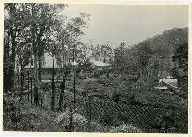
View of the Kalorama Gap from main Road (now Ridge Road), looking across Walker's raspberry patch with Mountjoy coaching stables on the LHS and Mountjoy Guest House in centre. Price's house and shop on the RHS.mountjoy, walker, raspberry, coach, stables -
 Buninyong & District Historical Society
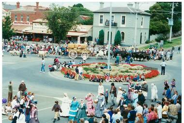
Photograph - Colour photograph, Buninyong Gold King Festival Feb.Feb.1995, view of Roundabout, Buninyong Gold King Festival Feb.Feb.1995, view of Roundabout
The Gold King festival celebrated transport and notable characters associated with Buninyong's early gold mining and farming days.The Gold King Festival was held for many years and was an important community celebration in the late 20th centuryColour photo, Buninyong Gold King Festival Feb.Feb.1995, view of procession featuring a cattle drawn wagon, livestock and pedestrians in 19th century period dress negotiating the roundabout taken from the Crown HotelBuninyong Festival, 19February 1995mining, gold king, de soza, transport, dress, procession