Showing 11662 items
matching 1970-1979
-
 Stawell Historical Society Inc
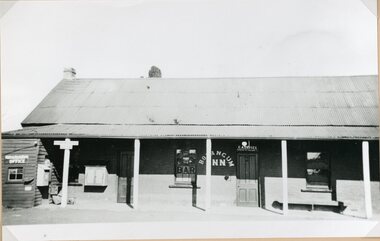
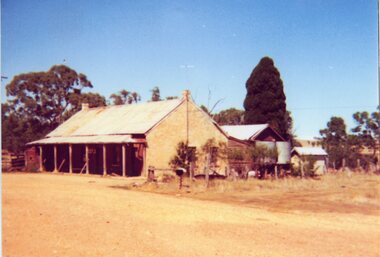
Photograph, Bolangum Inn at Kanya pre 1970
Bolangum Inn at Kanya pre 1970stawell -
 Stawell Historical Society Inc
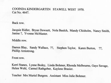
Photograph, Cooinda Kindergarten Stawell West 1970
Cooinda Kindergarten Stawell West 1970stawell -
 Stawell Historical Society Inc
Photograph, Lady Brooks Kindergarten Students 1970
Lady Brooks Kindergarten Students 1970stawell -
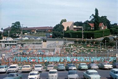
 Greensborough Historical Society
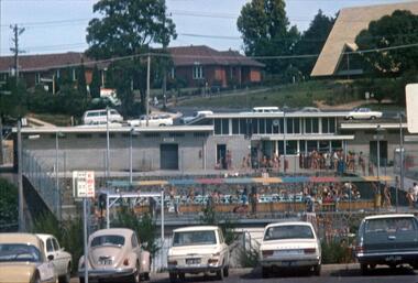
Photograph - Digital Image, R. Max Neumann, Greensborough Pool 1970, 1970_02
Greensborough Junior Swimming Pool in February 1970.An early photograph of the Pool, now demolished to make way for the Watermarc developmentDigital copy of colour photographgreensborough swimming pool, greensborough pool, watermarc -
 Stawell Historical Society Inc
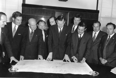
Photograph, Group of Councillors with Mr Murray Byrne MLC 1970
Group of Councillors with Murray Byrne MLC 1970stawell government -
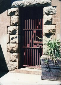 Stawell Historical Society Inc
Photograph, Pleasant Creek Gaol's Cell Door 1970
Pleasant Creek Gaol Cell Door 1970stawell -
Stawell Historical Society Inc
Newspaper, Weekly Times Newspaper Feature Article on the Town of Stawell 1970
Town of Stawell 1970 Weekly Times Feature.stawell -
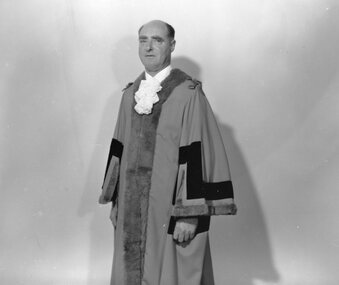 Stawell Historical Society Inc
Photograph, Cr Cyril Smith -- Mayor 1969-1970
Mayor 1969-1970 Cr Cyril Smithstawell government -
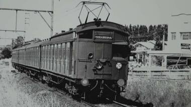 Greensborough Historical Society
Photograph - Digital Image, Hurstbridge bound train at road level, Watsonia 1970, 1970_
Hurstbridge bound train at road level, Watsonia 1970. Digital copy of black and white photographwatsonia station, hurstbridge rail line, trains -
 Greensborough Historical Society
Photograph - Digital Image, R. Max Neumann, Greensborough Main Swimming Pool 1970, 1970_02
Greensborough Swimming Pool, main pool, February 1970.An early photograph of the Pool, now demolished to make way for the Watermarc developmentDigital copy of colour photographgreensborough swimming pool, greensborough pool, watermarc -
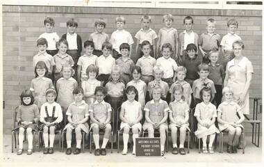
Stawell Historical Society Inc
Photograph, Stawell West Primary School Number 4934 Grade 4 -- Named 1970
Primary School Stawell West - Grade 4 1970stawell education students -
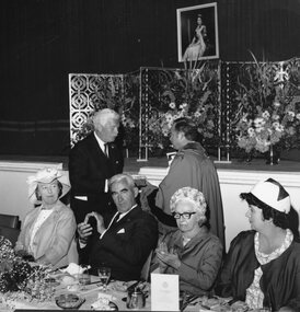 Stawell Historical Society Inc
Photograph, Stawell Town Council Centenary & the Official Luncheon 1970
Official Luncheon Stawell Town Council Centenary 1970stawell government -
 Stawell Historical Society Inc
Photograph, Bolangum Inn at Kanya post 1970 -- Coloured
Colour photo Bolangum Inn at Kanya post 1970stawell -
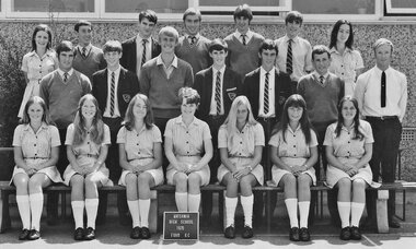
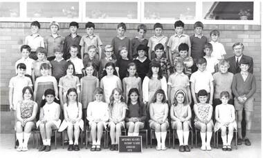
Stawell Historical Society Inc
Photograph, Stawell High School Form 3A -- Named 1970
Stawell High School Students Form 3A 1970stawell education -
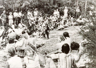 Eltham District Historical Society Inc
Photograph, Rally near the Koornung by the Warrandyte Environment League, c.1979, 1979c
Accompanying note with photo: "7/12/94 celebrating 22 years of understanding and partnership for the environment between the Shire of Eltham and Warrandyte Environment League. 1979 saw a great victory in North Warrandyte with the Hamer Government buying 'The Koornung' on the Yarra for addition to the Warrandyte State park. This photo is of one of the rallies organised near the property by the League. Best wishes to staff, Doug Seymour for WEL"Black and white photographkoornong, warrandyte environment league, warrandyte state park -
Moorabbin Air Museum
Book (item) - CAC Government Contracts ( January 1979) - Prepared by Working Party April 1979 Revised June 1979
-
 Eltham District Historical Society Inc
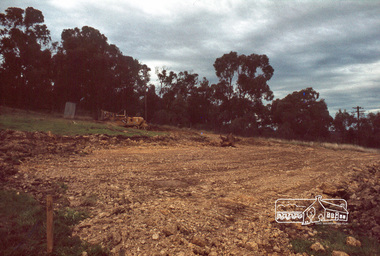
Photograph, Land size highlighted by Tiny and Carla Vermey standing at each corner, 1979
14 Stokes Place (Lot 83) was the home of Peter and Carla Vermey. The land was purchased in May 1979 and construction commenced September 1979. The home was built by Peter and Carla Vermey after the developer, Macquarie Builders went bankrupt. Sold October 2017 by Morrison and Kleeman Real Estate. Stokes Place was part of the Stokes Orchard Estate which was developed from the break-up of the the orchard owned by Frank Stokes who lived on the northeast corner of Nyora Road and Eucalyptus Road. His daughter Beryl advised that the Shire had levied a rate assessment on individual parcels of land within the orchard which became unaffordable resulting in its sub-division and sell off. The Stokes Orchard Estate was developed by Macquarie Builders in two stages starting with stage 1 in 1976. Stokes Place was part of Stage 2 in 1979. The Estate was bounded between Nyora Road, Eucalyptus Road, Diosma Road and Stokes Place. The original orchard only just reached the left most portions of Stokes Place and did not go fully up to Diosma, rather to just beyond the extant of Stokes Place. Stokes Place was known within the family as "The Oats" as that is where they grew oats. Frank Stokes moved to Eltham c.1945 after visiting Harold Bird to view his orchard, located diagonally opposite Stokes Orchard from the intersection of Eucalyptus Road, Pitt Street and Nyora Road. It was on Harold Bird's recommendation that Frank purchased the land.The Stokes Orchard Estate collection is typical of housing developments of the late 1970s and 1980s. It was one of the earliest estates in Eltham following the nearby Woodridge Estate development.Digital fileScanned by EDHS from 49 x 35mm colour transparencies provided on loanstokes place, eltham, stokes orchard, stokes orchard estate, streets, houses, peter and carla vermey -
 Eltham District Historical Society Inc
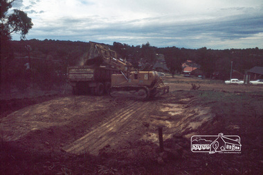
Photograph, Excavation of dwelling, 1979
14 Stokes Place (Lot 83) was the home of Peter and Carla Vermey. The land was purchased in May 1979 and construction commenced September 1979. The home was built by Peter and Carla Vermey after the developer, Macquarie Builders went bankrupt. Sold October 2017 by Morrison and Kleeman Real Estate. Stokes Place was part of the Stokes Orchard Estate which was developed from the break-up of the the orchard owned by Frank Stokes who lived on the northeast corner of Nyora Road and Eucalyptus Road. His daughter Beryl advised that the Shire had levied a rate assessment on individual parcels of land within the orchard which became unaffordable resulting in its sub-division and sell off. The Stokes Orchard Estate was developed by Macquarie Builders in two stages starting with stage 1 in 1976. Stokes Place was part of Stage 2 in 1979. The Estate was bounded between Nyora Road, Eucalyptus Road, Diosma Road and Stokes Place. The original orchard only just reached the left most portions of Stokes Place and did not go fully up to Diosma, rather to just beyond the extant of Stokes Place. Stokes Place was known within the family as "The Oats" as that is where they grew oats. Frank Stokes moved to Eltham c.1945 after visiting Harold Bird to view his orchard, located diagonally opposite Stokes Orchard from the intersection of Eucalyptus Road, Pitt Street and Nyora Road. It was on Harold Bird's recommendation that Frank purchased the land.The Stokes Orchard Estate collection is typical of housing developments of the late 1970s and 1980s. It was one of the earliest estates in Eltham following the nearby Woodridge Estate development.Digital fileScanned by EDHS from 49 x 35mm colour transparencies provided on loanstokes place, eltham, stokes orchard, stokes orchard estate, streets, houses, peter and carla vermey -
 Eltham District Historical Society Inc
Photograph, Excavation of garage, 1979
14 Stokes Place (Lot 83) was the home of Peter and Carla Vermey. The land was purchased in May 1979 and construction commenced September 1979. The home was built by Peter and Carla Vermey after the developer, Macquarie Builders went bankrupt. Sold October 2017 by Morrison and Kleeman Real Estate. Stokes Place was part of the Stokes Orchard Estate which was developed from the break-up of the the orchard owned by Frank Stokes who lived on the northeast corner of Nyora Road and Eucalyptus Road. His daughter Beryl advised that the Shire had levied a rate assessment on individual parcels of land within the orchard which became unaffordable resulting in its sub-division and sell off. The Stokes Orchard Estate was developed by Macquarie Builders in two stages starting with stage 1 in 1976. Stokes Place was part of Stage 2 in 1979. The Estate was bounded between Nyora Road, Eucalyptus Road, Diosma Road and Stokes Place. The original orchard only just reached the left most portions of Stokes Place and did not go fully up to Diosma, rather to just beyond the extant of Stokes Place. Stokes Place was known within the family as "The Oats" as that is where they grew oats. Frank Stokes moved to Eltham c.1945 after visiting Harold Bird to view his orchard, located diagonally opposite Stokes Orchard from the intersection of Eucalyptus Road, Pitt Street and Nyora Road. It was on Harold Bird's recommendation that Frank purchased the land.The Stokes Orchard Estate collection is typical of housing developments of the late 1970s and 1980s. It was one of the earliest estates in Eltham following the nearby Woodridge Estate development.Digital fileScanned by EDHS from 49 x 35mm colour transparencies provided on loanstokes place, eltham, stokes orchard, stokes orchard estate, streets, houses, peter and carla vermey -
 Eltham District Historical Society Inc
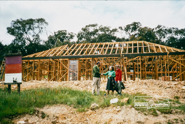
Photograph, Peter and Carla Vermey with Carla's Aunty Riena in front yard, house at framing stage; November 1979
14 Stokes Place (Lot 83) was the home of Peter and Carla Vermey. The land was purchased in May 1979 and construction commenced September 1979. The home was built by Peter and Carla Vermey after the developer, Macquarie Builders went bankrupt. Sold October 2017 by Morrison and Kleeman Real Estate. Stokes Place was part of the Stokes Orchard Estate which was developed from the break-up of the the orchard owned by Frank Stokes who lived on the northeast corner of Nyora Road and Eucalyptus Road. His daughter Beryl advised that the Shire had levied a rate assessment on individual parcels of land within the orchard which became unaffordable resulting in its sub-division and sell off. The Stokes Orchard Estate was developed by Macquarie Builders in two stages starting with stage 1 in 1976. Stokes Place was part of Stage 2 in 1979. The Estate was bounded between Nyora Road, Eucalyptus Road, Diosma Road and Stokes Place. The original orchard only just reached the left most portions of Stokes Place and did not go fully up to Diosma, rather to just beyond the extant of Stokes Place. Stokes Place was known within the family as "The Oats" as that is where they grew oats. Frank Stokes moved to Eltham c.1945 after visiting Harold Bird to view his orchard, located diagonally opposite Stokes Orchard from the intersection of Eucalyptus Road, Pitt Street and Nyora Road. It was on Harold Bird's recommendation that Frank purchased the land.The Stokes Orchard Estate collection is typical of housing developments of the late 1970s and 1980s. It was one of the earliest estates in Eltham following the nearby Woodridge Estate development.Digital fileScanned by EDHS from 49 x 35mm colour transparencies provided on loanstokes place, eltham, stokes orchard, stokes orchard estate, streets, houses, peter and carla vermey -
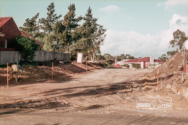
 Eltham District Historical Society Inc
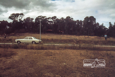
Slide, Reconstruction of Grand Boulevard viewed from Panorama Avenue, Montmorency, 18 August 1970, 1970
The Eltham Apex Club conducted a Community Service Project (1965-1968) to raise funds for a new Ambulance Station to service the community. A site bounded by the intersection of Main Road, Grand Boulevard and Looker Road at Montmorency was purchased in 1969. In 1970, Eltham Shire Council undertook roadworks to construct Apex Way in preparation for the new station as well as duplicate Main Road, Lower Plenty, east of Grand Boulevard including the new Lower Plenty Bridge, which had been opened in November 1966, bordering with the City of Heidelberg.35 mm colour positive transparency Mount - Agfacolor Service (Blue)1970-08-18, apex-diamond valley ambulance station, eltham ambulance station, eltham apex club, grand boulevard, montmorency -
 Eltham District Historical Society Inc
Slide, Construction of Apex Way between Looker Road and Grand Boulevard, Montmorency, 18 August 1970, 1970
The Eltham Apex Club conducted a Community Service Project (1965-1968) to raise funds for a new Ambulance Station to service the community. A site bounded by the intersection of Main Road, Grand Boulevard and Looker Road at Montmorency was purchased in 1969. In 1970, Eltham Shire Council undertook roadworks to construct Apex Way in preparation for the new station as well as duplicate Main Road, Lower Plenty, east of Grand Boulevard including the new Lower Plenty Bridge, which had been opened in November 1966, bordering with the City of Heidelberg.35 mm colour positive transparency Mount - Agfacolor Service (Blue)1970-08-18, apex-diamond valley ambulance station, eltham ambulance station, eltham apex club, grand boulevard, looker road, montmorency -
Port Melbourne Historical & Preservation Society
Book - Peter's All Round Year, 1970 ... 50 Years On, 2020
The book covers the career of South Melbourne Football Club Captain and 1970 Brownlow Medal winner, Peter Lawrence Anthony "Wheels" BEDFORD.White covered book with a collection of articles and information on the AFL South Melbourne Football Club Captain and 1970 Brownlow Medal winner, Peter Lawrence Anthony "Wheels" BEDFORD.Dean Jones & Nick. Best wishes Peter Bedford. 11 1970sport - australian rules football, peter lawrence anthony bedford, 50th anniversary -
 Greensborough Historical Society
School Photograph - Digital Image, Watsonia High School WaHIGH 1970 Form 6C, 1970_
A class photograph of Watsonia High School 1970 Form 6CDigital copy of a black and white class photowatsonia high school -
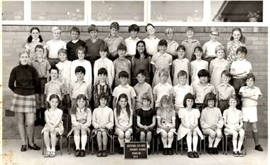 Greensborough Historical Society
School Photograph - Digital Image, Watsonia Heights Primary School WH4935 1970 Grade 4B, 1970_
A photograph of Watsonia Heights Primary School 1970 Grade 4BDigital copy of a black and white class photographwatsonia heights primary school -
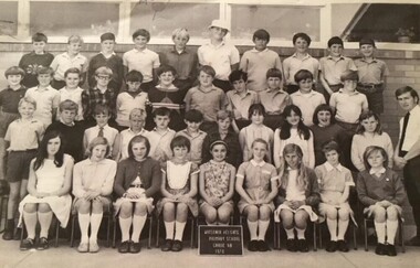 Greensborough Historical Society
School Photograph - Digital Image, Watsonia Heights Primary School WH4935 1970 Grade 6B, 1970_
A photograph of Watsonia Heights Primary School 1970 Grade 6BDigital copy of a black and white class photographwatsonia heights primary school -
 Greensborough Historical Society
School Photograph - Digital Image, Watsonia Heights Primary School WH4935 1970 Grade 1A, 1970_
A photograph of Watsonia Heights Primary School 1970 Grade 1ADigital copy of a black and white class photographwatsonia heights primary school -
 Greensborough Historical Society
School Photograph - Digital Image, Watsonia Heights Primary School, Watsonia Heights Primary School WH4935 1970 Grade 4A, 1970_
A photograph of Watsonia Heights Primary School 1970 Grade 4AA black and white photograph of school class groupwatsonia heights primary school -
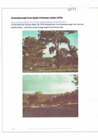 Greensborough Historical Society
Article and Photograph, Greensborough from Apollo Parkways estate 1970, 2016_
Information and photos of Greensborough and the Apollo Parkways estate in October 1970.This photograph and text was copied from a Facebook site. Members are people who lived in the Greensborough area and share their reminiscences of the area with others. The site is administered by a GHS member but is not officially affiliated with the Society. Any information is the opinion of the contributor. Article and photograph sourced from social media.greensborough, apollo parkways -
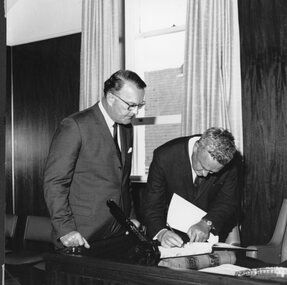 Stawell Historical Society Inc
Photograph, Stawell Town Council Centenary & signing of the Visitors Book 1970
Signing of visitors book Stawell Town Council Centenary 1970stawell government