Showing 18613 items matching "coloured"
-
 Stawell Historical Society Inc
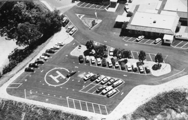
Photograph, Stawell Hospital Heli Pad 2001-- 2 Photos -- Coloured
Two colour views of Heli Pad Stawell Hospital 2001stawell hospital -
 Stawell Historical Society Inc
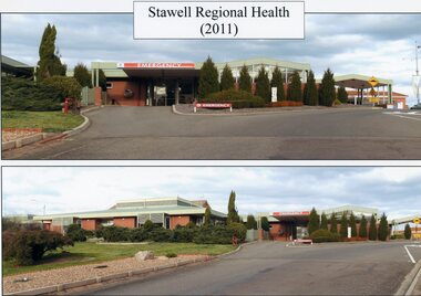
Photograph, Stawell Regional Health 2011 -- 2 Photos -- Coloured
Two colour photos of Stawell Regional Health 2011 stawell hospital -
 Stawell Historical Society Inc
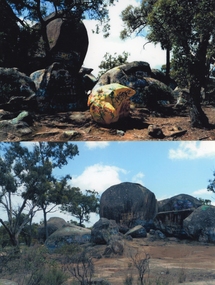
Photograph, Sister Rocks looking West --2 Photos -- Coloured
Two colour photographs of Sister Rocks Stawell. Looking West. c 2011 Two colour photographs of Sister Rocks taken from the west c 2000 -
 Stawell Historical Society Inc
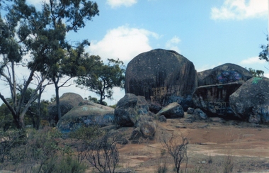
Photograph, Sister Rocks 2011-- Coloured photograph looking South
Colour Photograph Taken c 2011 Sister Rocks Stawell This photo is of a well known land mark along the Western Highway. They take their name from 3 sisters named Levy, who camped there with their parents during the early days of Stawell.Colour Photograph of Sister Rocks looking South c 2011South Taken c 2011stawell tourism -
 Stawell Historical Society Inc
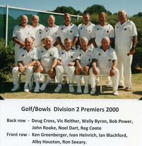
Photograph, Stawell Golf/Bowls Bowling Club Division 2 Premiers 2000 -- Coloured & Named
Stawell Golf/Bowls Bowling Club Division 2 Premiers 2000stawell -
 Federation University Historical Collection
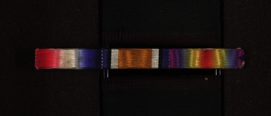
Service Medal Colour Bar, Chatham-Holmes Collection: Lance Corporal Horace Pickford's WW1 Army Coloured Ribbon Bar, c2020
Horace Pickford was Mary Elizabeth Chatham's ( nee Holmes) mother's bother Horace Pickford Service number 2882 Rank Lance Corporal Unit 58th Australian Infantry Battalion Service Australian Imperial Force Conflict/Operation First World War, 1914-1918 Award Distinguished Conduct Medal A service ribbon bar, or small ribbon mounted on a small metal bar equiopped with an attachig device, which is issued for wear in place of a medal when it is not appropriate to wear the actual medal. This service medal belonged to Horace Pickford.chatham-holmes collection, army, numismatics, colour bar, horace pickford, ww1, clunes -
 Stawell Historical Society Inc
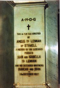
Photograph, St. Patrick’s Catholic Church main Alter -- 2 Photos -- Coloured
Two colour photos of altar stones inside St. Patrick’s Catholic Church. One of the altar stones was erected in memory of the McLennan family. The other is of the 12 apostles at the last supper. Two colour photographs of Altar stones inside St. Patrick's Catholic Church. The photos are also in Album 2 p.54. One photo is of the 12 apostles at the last supper. The other a memorial to past members of the McLennan family.A-M-D-G This altar was erected by Angus McLennan of Stawell in memory of his deceased parents John and Isabella McLennan and his deceased brothers Duncan and John - 30th December 1927stawell -
 Stawell Historical Society Inc
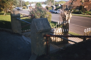
Photograph, St. Patrick’s Catholic Church Street entrance -- 4 Photos -- Coloured
Four different colour views of St. Patrick’s Catholic Church entrance. Two photos show the entrance gate from the pathway. One the top of the entrance gate from the pathway. The last photo is of the steps and handrail entrance to the Church.Four colour photographs of the steps and entrance ways to St Patrick's Catholic Church. Three photos show the gate entrance from the pathway and road. The one other photo is of the steps to the Church.stawell -
 Stawell Historical Society Inc
Photograph, St Patricks Church Residence 2000 -- 2 Photos -- Coloured
Six photos of the exterior and interior of Thomas Kinsella's past residence in grounds of St Patrick's Catholic Church taken 2000. The house "Donanore" was built in 1900 by Thomas Kinsella and was the family residence for many years. The Stawell news of 26.1.1924 reported the arrival of nuns from the order of Sisters of Joseph. The nuns resided in the house for many years. Three of the six photos are of the interior. One of the front door surrounded by stained glass windows. Another a detail of an external door. The third a view of a statue at the end of the hallway. The photos are in Album 2 p. 52 & 53.Six colour photos taken in 2000 of "Donanore" Tomas Kinsella's residence in the grounds of St Patrick's Catholic Church. Three different views of the house and three photos of the interior entrance and hallway. The house is a red brick house with grey trim and a verandah out the front with a slate roof. stawell -
 Stawell Historical Society Inc
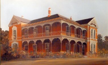
Photograph, "Oban" House as painted in Oil by Mr John Glover -- 2 Photos -- Coloured
Two Colour photos of original oil painting of Oban by John Gloverstawell houses -
 Stawell Historical Society Inc
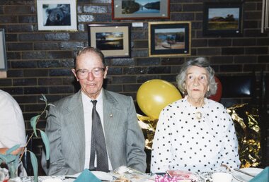
Photograph, Mr Bill Kinsella & Miss Carmel Kinsella -- Series of Photos -- Coloured
3600 Bill Kinsella and Carmel Kinsella at Carmel's Birthday party. -1 Carmel Kinsella cutting her birthday cake. -2 Carmel Kinsella. -3 Three photographs of cloths belonging to the Kinsella family. -4 Three photos of clothing, one of a purple silk undergarment, one of black silk dress the third of a embroidered. -5 Three photos, one of a top hat, another of long boots and the third a Bullock drivers bell. -6 Photograph of Illumination given to Thomas Kinsella from the Magdala mine workers when Thomas left to travel back to Ireland to visit his sick mother. -7 Four photographs of objects, one of a Pianola, second of a clock Carmel Kinsella bought for her birthday (80th in 1993). Third wire strainers, Forth Croquet green numbers and mallet head. -a Wording on Illumination (see description, inscriptions and markings). -8 Photograph of Martin Cahill. Born 1881 died 21.06.1947. Married to Eileen Kinsella 1920. -9 Bill Kinsella at 3LK Radio Starion Lubeck where he worked for 38 years. Bill was also called William Jennings Kinsella after his father. -10 The iron decorative gates at Kinsella's farm also called "Magdala" -11 The original Kinsella house on "Magdala" farm. The back room with a flat roof and 4 windows was moved from "Mayo Park" where the Kinsella's originally lived across Station Creek. -12 Photo of Tom Capell as a young man. The son of Jane Teresa Kinsella & William A. Capell. -13 Sarah Kinsella nee Peardon married William Jennings Kinsella. -14 Photograph of Sarah & Jennings Kinsella children Thomas Wade Kinsella, Clare Best, Carmel Kinsella, Bill Kinsella. Photo taken at Kendal's farm near Lubeck Series of colour and black and white photographs taken at the Kinsella's farm "Magdala" Lubeck July 2006.stawell -
 Colac RSL Sub Branch
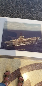
Photograph - Photograph of HMAS Melbourne in a presentation folder, Presentation folder
Photograph of the Australian Aircraft Carrier HMAS MelbourneHigh. Australia does not have an aircraft carrierGray coloured presentation folder with a photo of HMAS Melbourne and map inside Coloured photo of HMAS Melbourne -
 Vision Australia
Document - Text, Royal Blind Society vision and mission
The vision and mission of the Royal Blind Society.1 A4 cream coloured page with maroon writingMaroon coloured frame around pageroyal blind society of new south wales, office equipment -
 Ringwood RSL Sub-Branch
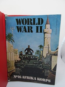
Book - number 16, Afrika Corps, WW11 History Magazines, 1972
Red binder containing coloured magazines on WW11 Published in WW11 Printed text containing coloured and black and white photographs -
 Bendigo Military Museum
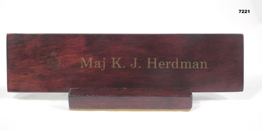
Plaque - NAME PLAQUE
Part of the Kevin John Herdman, No. 397661, Collection. See Catalogue No. 5942P for details of his service record.Brown coloured wooden name plaque on an attached wooden stand. Felt covering on base of stand. Owner's name in gold coloured lettering. RACT unit badge in gold preceding name.In gold coloured lettering: “Maj K. J. Herdman”name plaque, kevin john herdman -
 Glenelg Shire Council Cultural Collection
Book - Book - Victorians Celebrate, Victorians Clelebrate, c. 1985
Book, the Official Anniversary Souvenir Record of Victoria's 150th. Paperback, covers multi-coloured, various views of Victoria, photo of Prince Charles and Princess Diana, 150th logo bottom left, white pages, black and coloured print, coloured and black and white photosFront: Book, the Official Anniversary Souvenir Record of Victoria's 150th. Paperback, covers multi-coloured, various views of Victoria, photo of Prince Charles and Princess Diana, 150th logo bottom left, white pages, black and coloured print, coloured and black and white photos -
 Mont De Lancey
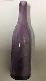
Glass bottle
13oz Rosella Preserving Co mauve coloured glass bottleRosella Preserving Co imprinted on 13oz mauve coloured bottle -
 Greensborough Historical Society
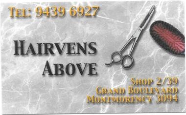
Business card and leaflet, Hairvens Above, 13/12/2014
Coloured business card and coloured invitation to closing party for patrons 13/12/2014.Coloured business card and coloured invitation leaflet.hairvens above, grand boulevard montmorency -
 Friends of Ballarat Botanical Gardens History Group
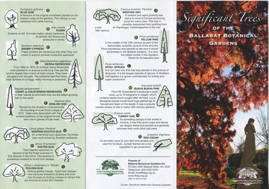
Work on paper - Significant Trees of the Ballarat Botanical Gardens, List and Map, c 2018
These trees planted in the nineteenth century are an exceptional collection of exotic conifers and deciduous trees.These trees classified by the National Trust means that the trees are an essential part of Australia's heritage and should be preserved for future generations.A coloured pamphlet divided into three parts, with trees and coloured picture on one side and a map of where the trees are situated on the other.Right hand corner of coloured picture, there is the logo of the Friends of the Ballarat Botanical Gardensjohn garner collection, dr, significant trees, ballarat botanical gardens, gardens, ballarat, map -
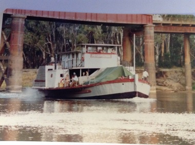 Port of Echuca
Photograph - Coloured, March 1984
This photograph was taken in February 1984 on the occasion of Cossen's visit to Echuca. P.S Pevensey with the name Philadelphia written across the wheelhouse can be seen steaming upstream under the bridge. This is significant because the P.S Pevensey played the role of the P. S Philadelphia in the movie "All The Rivers Run" which was filmed in Echuca in late 1982 and a sequel was filmed in Echuca early in 1989. Councillor Bob Snow can also be seen on the side deck. This is significant as the Cossen's visit to Echuca may have warranted this sort of attention The photograph also shows the state of the Echuca Moama bridge in the early 1980's.This photograph is significant because it shows the P.S. Pevensey showing the name P.S Philadelphia. The P.S Pevensey was used as the P.S Philadelphia in the TV Series "All The Rivers Run" based on the novel written by Nancy Cato. The TV series was filmed in Echuca in 1982. The TV series was a huge success and still draws tourists to the Port of Echuca. The fact that the P.S Pevensey was showing the Philadelphia name in 1984 is a bit of a mystery, but it has been known that she was dressed up again as the P.S Philadelphia sometimes for special occasions. The Cossen's visit to Echuca might have been such an occasion. It is also a good picture of the pylons under the Echuca Moama bridge and the actual bridge itself. The P.S Pevensey travelling upstream under the Echuca Moama bridge. There is a group of people on the lower side deck. People can also be seen in the wheelhouse and there is a man standing on the back deck as well as one standing next to the wheelhouse. The name Philadelphia can be seen written across the front of the wheelhouse. The river is low and shows the waterline at the Moama Beach. Four bridge pylons can be seen as well as the bridge itself.greenspot photography, p.s pevensey, murray river, echuca, la grue, bill, cossen's visit to echuca., all the rivers run, p. s philadelphia, echuca moama bridge, cossen family, cato, nancy -
 Halls Gap & Grampians Historical Society
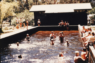
Photograph - Coloured, C 1957
The Halls Gap Swimming Pool. ' Caravaners who visit Halls Gap will find facilities for up to 200 caravans, shelter, water laid on, swimming pool, paddling pool for children, with swings &:firewood, kitchen comfort station with showers, lounge and sewered conveniences under the care of a reliable and courteous caretaker. Stores and bowsers are close handy. Milk and bread are delivered at the camp each day and meat four times a week. The fees are 7/0 for first week and 5/0 a week thereafter." article from Argus Mon.15/1/1940 article with photograph aboveThe photo shows a swimming pool (Halls Gap pool) with a building in the background. Women and children are in the pool, seated around the edge and on the surrounding grassy areas. There is sunlight reflecting on the water. Bush can be seen in the background.recreation, swimming pool -
 Halls Gap & Grampians Historical Society
Photograph - Coloured, 1955
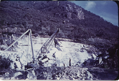
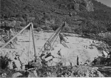
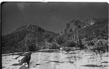
Heatherlie QuarryHeatherlie Quarry - Photo shows 2 people standing in quarry. Machinery in foreground; rock-face middle distancequarrying, mt difficult quarry -
 Halls Gap & Grampians Historical Society
Photograph - Coloured, 1955
Heatherlie QuarryHeatherlie Quarry - Photo shows 2 people standing in quarry. Machinery in foreground. Rock-face middle distancequarrying, rocklyn -
 Halls Gap & Grampians Historical Society
Photograph - Coloured, 1955
Part of rockface at Heatherlie Quarryquarrying, mt difficult quarry -
 Halls Gap & Grampians Historical Society
Map - Coloured
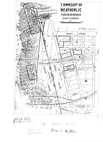
Map showing layout for township of HeatherlieTownship of Heatherlie; Parish of Boroka; County of Borung; scale measurement; R.O. Robson Authorised surveyormaps, heatherlie township -
 Halls Gap & Grampians Historical Society
Photograph - Coloured, C 1960
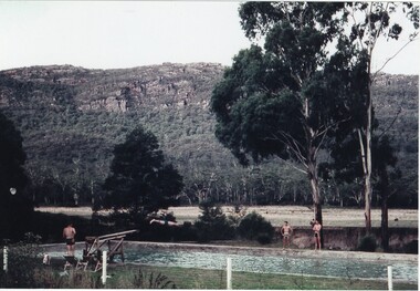
Jack Deller at end of diving board Graeme Chappell diving off of board Darryl Williams left and Doug Bottoms right opposite side of pool Occasion was Graeme's 21st birthdayPeople enjoying pool and diving board at Myrtlebank Guest House overlooked by Mt William Range.AGFApeoplerecreation, sport -
 Halls Gap & Grampians Historical Society
Photograph - Coloured, C 1930
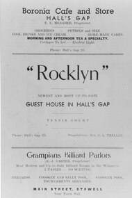
Photo shows Advertising sheet divided into three sections - 'Boronia cafe and Store Halls Gap'; '"Rocklyn" - Guest House in Halls Gap'; 'Grampians Billiard Parlours'.media, flyers, buildings, shops -
 Halls Gap & Grampians Historical Society
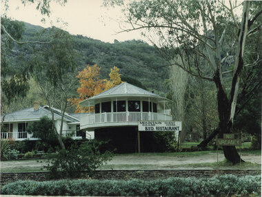
Photograph - Coloured, C 1987
Mountain Grand guest house in Autumn Guest House in Halls GapAutumn Halls Gap 87/3guesthouses, mountain grand -
 Halls Gap & Grampians Historical Society
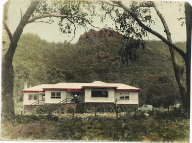
Photograph - Coloured, C 1940
Appears to be older period possibly 1940s because of the age of the carGuest on verandah, car at side of Guest Houseaccommodation, guesthouses, mountain grand -
 Halls Gap & Grampians Historical Society
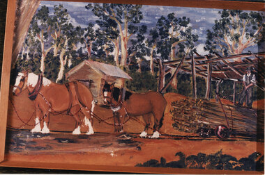
Photograph - Coloured, Early 20th C
A tramline was built to bring logs down from a mill up on Stoney Creek. The tramline was made of timber and the trolleys of logs were pulled as afr as possible by horse and then a driver would ride the logs down to the flat land below pulling a brake when nearing the end. (Close to site of present Primary School).Photo is a copy of Anne Borella (nee Nicholson) depicting the haulage of timber along a tramline. Two horses are pulling a trolley while a driver stands on the load with the wheelbrake ready.transport, horse drawn, structures, tramway