Showing 606 items
matching department store
-
 Moorabbin Air Museum
Book (item), Richard Taylor, Fair-Weather Flying: For VFR Pilots who want to improve their skills and flying enjoyment
Contains a document from the Australian Department of Transport, stating that the receiver is eligible to be issued with a Visual Flight Guide from the government. It is unclear if this book was the guide sent, or whether the letter and the book are unrelated but have been stored together by previous owner/s. -
Moorabbin Air Museum
Document (item) - Department of Aircraft Production Bristol Beaufort Beaufort Production Training Notes, DAP Training Notes Balmain WW2 (Beaufort Production)
Provenance of item (from Balmain, NSW, during World War Two as part of the Department of Aircraft Production) is largely reliant on the title of the folder the document is stored in, rather than the document itself. -
 Tatura Irrigation & Wartime Camps Museum
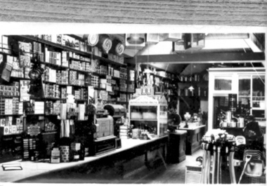
Photograph, Williams' Store and Grocery Department 1880
... Williams' Store and Grocery Department 1880...Frank Williams' Store and Grocery Department, Hogan Street... and Grocery Department, Hogan Street, interior 1880. Williams' Store ...Frank Williams' Store and Grocery Department, Hogan Street, interior 1880.tatura, buildings, historic -
University of Melbourne, Burnley Campus Archives
Negative - Black and white negatives, Cows, Unknown
... ). The negatives are stored in a Department Of Agriculture, Victoria... [Cows] (B91.453). The negatives are stored in a Department ...From Record Book Stock Breeding Record [Cows] (B91.453). The negatives are stored in a Department Of Agriculture, Victoria envelope.3 black and white negatives of cows. See B91.68-70.stock breeding record, cows -
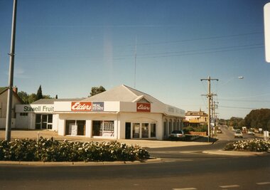 Stawell Historical Society Inc
Photograph, Stawell Main Street Shops from Patrick Street to St Georges Street 1998 -- 40 Photos
Main Street Shops Patrick Street to St Georges Street - 1998Elders Real Estate, The Top shop Milkbar and three other shop in Patrick Street 2 photos, Big Hill Art & Framing, 2 shops Unknown, Mechanics institute St Vincent De paul Op Shop, Whiting Accountants, Imbros Books, Salvation Army Thrift shop, Curtis & Thomas Charted Accountants, Westpac Bank, Sports Power, Unknown Craft Shop, T.A.B., Perrys Shoes, RetraVision, Kahula Botique, Total Music, Latus Jewellers, Sit of te Bull and Mout Hotel, Earles Festiva Supermarket, Rotunda in the Mall removed when the Mall Was, Boags Cycles and Sports, Haymes Mensland, Gar-El - Attrills Florest, Civic Store, Stawell News Agency, Pleezall Cafe, M ined r Pic, Gold Reef Greeting Cards and Gifts, Public Information Centre, Amcal Chemist, Aquarius Milkbar, Classic Shoes, Sheer Illusions, Gold Reef Chinese Restaurant, Blizzard Optometirist, Toyworld, Post Office Arcade was Post Office Hotel, MItre 10 Timber Yard, David O Jones Mitre 10, Sniff "N" Tell, Unkown Clothing Shop, Think of Me Gift Shop, Stawell Florists, Goodonya Sports, Slavation Army Thrift Shop, Chris & Di's Pies, Salon 74 Hairdresser, Town Hall Sandwich Bar, Rauncy Rooster, Townhall Hotel. Peter Steggall Physiotherapist, Stawell Time News Office, Stawell Bakery, C.E.S , Department of Human Services, Salvation army Citadel, Two Shops Unoccupied at time of Photo.stawell -
 National Wool Museum
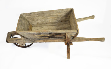
Wheelbarrow
Used in the Produce Department of Denny Lascelles bluestone wool store for carrying bales -
 National Wool Museum
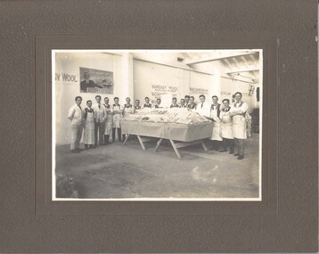
Photograph
Photo depicts a final year woolclassing class from the Gordon Institute in Geelong. They have prepared a display re: woolclassing for the visit of the Prince of Wales to Geelong in 1920. They are on the top floor of the Dennys Lascelles woolstore. The donor's father, Mr Cyril Cameron, can be seen in the photo at sixth from the right. Cyril Cameron (known as 'Cam') came from the family property 'Burnside' near Glenthompson in the Western District. He joined Strachan & Co. as an office boy in Aug. 1914 and then joined the 8th Battalion, 1st AIF in January 1915. He returned to Australia in early 1920 and started work at Strachan's again. He did the wool classing course (one year, evening?) at the Gordon in 1920-21. He became Head Wool Valuer at Strachan's in 1938 and retired in 1970. His office at Strachan's was on the top floor, directly overlooking what is now the entrance to the National Wool Museum (formerly Dennys Lascelles woolstore). He died in 1983. Interestingly, within the photo, can be seen a poster on the wall advertising the RSS or Diggers' Mill. The mill opened in 1922 but had been advertising for investors since the end of the war.Photograph, Gordon Technical College wool classing course, 1920. Wool classing display for the visit of the Prince of Wales at the Dennys Lascelles wool store.GEOFFREY S. WOOD, PHOTO, GEELONG Dennys Lascelles Show Floor 1920 / Visit of Prince of Waleswoolclassing royal visits, gordon technical college - woolclassing department, cameron, mr cyril, dennys lascelles wool store, woolclassing, royal visits -
 National Wool Museum
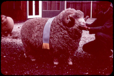
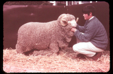
Slide, Fine Merino Ewes
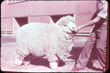
Slide of a fine Merino ewe. Fine merinos produce slightly longer and stronger wool than the super fine, but are found in the same higher rainfall areas ie. Western District of Victoria, the midlands district of Tasmania, New England and Yass districts of NSW. Formerly stored in presentation folder as part of "Merino & Australasian Breeds of Sheep Set No. A866" series by the Audio Visual Education Centre, Education Department of Victoria.Slide of a fine Merino ewe.Merino & Australasian Breeds / of Sheep / Set No. A866 / No. 2 / Fine Merino Ewes VISUAL EDUCATION CENTRE / EDUCATION DEPT. OF VICTORIAmerino sheep, slide -
 National Wool Museum
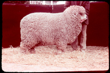
Slide, Medium Merino ram
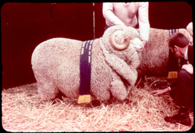
Slide of a medium Merino ram. Medium or Peppin merinos are found in the vast inland of Australia where rainfall varies between ten and twenty inches annually. Peppin-type sheep produce the greatest quantity of wool of any breed or type of sheep in Australia. Formerly stored in presentation folder as part of "Merino & Australasian Breeds of Sheep Set No. A866" series by the Audio Visual Education Centre, Education Department of Victoria.Merino & Australasian Breeds / of Sheep / Set No. A866 / No. 3 / Medium Merino Ram VISUAL EDUCATION CENTRE / EDUCATION DEPT. OF VICTORIAmerino sheep, peppin merino sheep, peppin-merino sheep -
 National Wool Museum
Slide, Strong Merino ram
Slide of a strong Merino ram. Strong merinos are usually grazed in the semi-arid areas of the inland where the annual rainfall is below ten inches. Formerly stored in presentation folder as part of "Merino & Australasian Breeds of Sheep Set No. A866" series by the Audio Visual Education Centre, Education Department of Victoria.Slide of a strong Merino ram.Merino & Australasian Breeds / of Sheep / Set No. A866 / No. 4 / Strong Merino Ram VISUAL EDUCATION CENTRE / EDUCATION DEPT. OF VICTORIAmerino sheep -
 National Wool Museum
Slide, Poll Polwarth
Slide of a Poll Polwarth sheep. Polwarths are found in the colder, wetter areas of Victoria and Tasmania and have been exported to South America. Formerly stored in presentation folder as part of "Merino & Australasian Breeds of Sheep Set No. A866" series by the Audio Visual Education Centre, Education Department of Victoria.Slide of a Poll Polwarth sheep.Merino & Australasian Breeds / of Sheep / Set No. A866 / No. 5 / Poll Polwarth VISUAL EDUCATION CENTRE / EDUCATION DEPT. OF VICTORIApoll polwarth sheep, slide -
 National Wool Museum
Slide, Horned Polwarth
Slide of a Horned Polwarth sheep. Polwarths are found in the colder, wetter areas of Victoria and Tasmania and have been exported to South America. Formerly stored in presentation folder as part of "Merino & Australasian Breeds of Sheep Set No. A866" series by the Audio Visual Education Centre, Education Department of Victoria.Slide of a horned Polwarth sheep.Merino & Australasian Breeds / of Sheep / Set No. A866 / No. 6 / Horned Polwarth VISUAL EDUCATION CENTRE / EDUCATION DEPT. OF VICTORIApolwarth sheep, slide -
 National Wool Museum
Slide, Corriedale
Slide of a Corriedale sheep. Corriedales are a large framed sheep which are favoured as wool and mutton producers in good pasture country in Australia and New Zealand. Corriedale sheep has been exported to South America. Formerly stored in presentation folder as part of "Merino & Australasian Breeds of Sheep Set No. A866" series by the Audio Visual Education Centre, Education Department of Victoria.Slide of a Corriedale sheep.Merino & Australasian Breeds / of Sheep / Set No. A866 / No. 7 / Corriedale VISUAL EDUCATION CENTRE / EDUCATION DEPT. OF VICTORIAcorriedale sheep, slide -
 National Wool Museum
Slide, Zenith
Slide of a Zenith sheep. The Zenith is a comparatively new breed established in the Victorian Wimmera and is a comeback type of sheep. Formerly stored in presentation folder as part of "Merino & Australasian Breeds of Sheep Set No. A866" series by the Audio Visual Education Centre, Education Department of Victoria.Slide of a Zenith sheep.Merino & Australasian Breeds / of Sheep / Set No. A866 / No. 8 / Zenith VISUAL EDUCATION CENTRE / EDUCATION DEPT. OF VICTORIAzenith sheep, slide -
 National Wool Museum
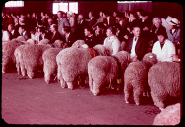
Slide, Merino Champions
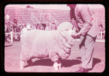
Slide of several champion merino sheep at the Australian Stud Breeders Association Show. Formerly stored in presentation folder as part of "Merino & Australasian Breeds of Sheep Set No. A866" series by the Audio Visual Education Centre, Education Department of Victoria.Slide of champion Merino sheep at the Australian Stud Breeders Association Show.Merino & Australasian Breeds / of Sheep / Set No. A866 / No. 9 / Merino Champions VISUAL EDUCATION CENTRE / EDUCATION DEPT. OF VICTORIAmerino sheep, australian association of stud merino breeders limited, slide -
 National Wool Museum
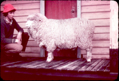
Slide, Super Fine Merino Ram
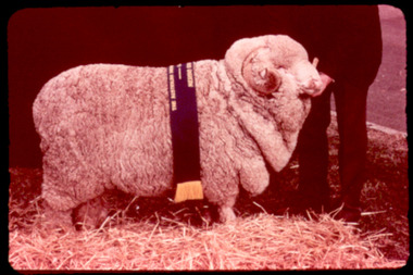
Slide of a superfine Merino ram. A superfine merino produces the finest and best wool in the world. Found in higher rainfall areas. Formerly stored in presentation folder as part of "Merino & Australasian Breeds of Sheep Set No. A866" series by the Audio Visual Education Centre, Education Department of Victoria.Slide of a superfine Merino ram.Merino & Australasian Breeds / of Sheep / Set No. A866 / No. 1 / Super Fine Merino Ram VISUAL EDUCATION CENTRE / EDUCATION DEPT. OF VICTORIAmerino sheep, wool superfine, slide, wool - superfine -
 Mt Dandenong & District Historical Society Inc.
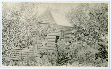
Photograph, Home and Shop of Edward Joseph Price
John Lundy-Clarke grew up in the Kalorama/Mt Dandenong area and later in life (1972-74) began to write a comprehensive history of the district working from an original settlement map in an effort to cover all areas. Edward Joseph Price was the first settler to take up a lot (Lot 1, Section 1) in the Village Settlement. He built a slab hut and brought up his family in 1896. This photograph shows a newer home built in 1908. It had a section used as a shop and also had a large room built that was to be used for public gatherings. Health department regulations led to this being impossible. The house faced Ridge Road.Black and white close up photograph showing a building made from wooden boards with trees in the front. Reverse of photograph has handwritten description by John Lundy-Clarke.On Front STORE MT DANDENONG On Reverse Home and Shop of Edward Joseph Price LOT 1 SECT 1 erected in 1908 on site of earlier dwelling from which goods had been sold without a special room for shop. In picture the room on the extreme left was bedroom for boys Charlie and Ted (Edward John). Under the gable was a large room planned for public use but never used owing to Health Department Regulations. The narrow door (open) and window were the shop which was the district’s first newsagency. Window behind leaves at right was the kitchen. 1908-1912. Gabled portion is now part of home “Mirra Laken” 1975edward joseph price, store, shop -
 Ballarat Tramway Museum
Administrative record - Memorandum, State Electricity Commission of Victoria (SECV), "Tramways - Derailments (Major)", May. 1959
Yields information about the provision of derailment equipment to be stored at the rear of the city offices., Yields information about the provision of derailment equipment to be stored at the rear of the city offices.Memorandum on Electricity Supply Department letterhead, foolscap, from the Works Superintendent to the Branch Manager with a copy to the Tram Depot Foreman, dated 19-5-1959, providing a list of re-railing equipment to be provided at the rear of the City Offices and details of keys to the locker.trams, tramways, derailments, sec showroom sturt st, equipment -
 Ballarat Tramway Museum
Newsletter, Ballarat Tramway Preservation Society (BTPS), "Information for Members and Interested Parties" - 10/71 to 5/73, 1971 to 1973
12 issues of BTPS Newsletter, titled "Information for Members and Interested Parties" from Oct. 1971 to May 1973, with sales sheets and other sheets. All printed, unless noted otherwise, on stencil duplicator using white duplicator paper, foolscap sized sheets. Listed by Neville Gower 10/98 on cover sheet. Some signed by Paul Nicholson Publicity Officer, some noted as edited by N.Gower. Oct. 1971 -pp2 - plus appeal for financial assistance Dec. 1971 - pp2 Jan. 1971 - p2 Feb. 1972 - pp2 - plus list of "Tramcar allocations in Melbourne 1/1/1972" - pp2 ( 2 copies) (with heat sensitive paper copy of this list, stapled in top left hand corner - pp2) Mar. 1972 - pp2 - plus list of disposal of SECV Ballarat tramcars - pp2 April May 1972 - orange paper, plus supplementary foolscap sheet on green paper, for "Bring back 39 to Ballarat", "Sales Department list" and "Driving Training" expression of interest. (2 copies) June-July 1972 - pp2 (2 copies)(copy imaged) September 1972 - pp2 - plus appeal for BTPS funds, p1 on yellow quarto paper. November 1972 - pp2 - plus sales items, 2 sheets, one on blue quarto paper December 1972 - pp2 - plus sale items, pp2 February 1973 - pp2 plus sales items pp2 on light blue paper May 1973 - pp2 plus sales items pp2 on light green paper, with advertisement of Jack Chadwick, Manager of B.V. Menswear Store of 251 Chapel St. Prahran. various notes, dates received, "Noelene's copy" and other notes on some issues in pencil and ink.museums btps, btps newsletters, publicity, sales items -
 Ballarat Tramway Museum
Photograph - Black & White Photograph/s, The Courier Ballarat, 22/11/1968 12:00:00 AM
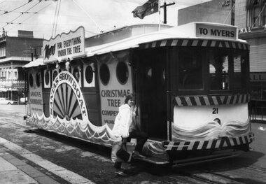
... department store. tramways trams Sturt St Myers Decorated Trams ...Yields information about Ballarat's decorated trams for Christmas and other events or fund raising. The basic decoration was able to recycled for other events as well. Tram decorated for Myers, at the time, a major department store.Black and White copy photograph of a newspaper photograph taken by The Courier, published 22/11/1968 of No. 21, decorated as "Santa's showboat", Sturt & Lydiard Sts corner, with a young lady passenger posed as boarding the tramcar. Decorated for Myers as a Christmas tram. Collected by Alan Bradley from the Ballarat Courier early 1980's. See Excel file "Record of Ballarat Courier Photos SEC era" (Archive Documents) for source of details.On rear stamped "Copyright, The Ballarat Courier Proprietary Limited."tramways, trams, sturt st, myers, decorated trams, christmas trams, tram 21 -
Kew Historical Society Inc
Archive (series) - Subject File, ANNEAR, Harold Desbrowe (1865-1933), 1991
Various PartiesReference, Research, InformationKHS Imposed OrderReference file containing a single text by Ms. Kirby A. Foreman, entitled Harold Desbrowe Annear’s Early Works, (completed as a major project (AJ901) in the Department of Architecture of Royal Melbourne Institute of Technology). Ms Foreman donated a copy of the Study to the Society in 1991. The 147-page project report includes a history, and appendixes of documents, designs and photographs of buildings. architects - victoria, springthorpe memorial, fairview - wrixon street - kew (vic.), harold desbrowe-anneararchitects - victoria, springthorpe memorial, fairview - wrixon street - kew (vic.), harold desbrowe-annear -
Kew Historical Society Inc
Archive (Sub-series) - Subject File, Floral, Industrial and Art Society (Kew), 1958
Various partiesReference, Research, InformationProvenance OrderSubject file containing six examples of printed ephemera, once owned by Amy Grigg of Pakington Street. Most of the items relate to awards given by the Kew Floral, Industrial and Arts Society, while another is a certificate issued by the Victorian Education Department as a ‘Certificate of Exemption from Compulsory Education’, dated 1891. The latter was ‘dated’ at Kew. The five awards given by the Society were for achievement in baking, writing and sewing. A later hand has added the date 1889 to these certificates. Also in the file is a newspaper article donated by Miss Henty that describes the first exhibition of the Society.kew (vic) - history, kew floral industrial and art society, amy griggkew (vic) - history, kew floral industrial and art society, amy grigg -
 Kew Historical Society Inc
Map, MMBW, MMBW Town of Kew, 1910-21
The Melbourne and Metropolitan Board of Works (MMBW) was established by an act of the Victorian Parliament in 1890 to prepare for and to implement a sewerage and water reticulation system across what was then inner Melbourne, its surrounding and middle distance suburbs, including Kew. The MMBW was disbanded in 1991.The map collection of the Kew Historical Society has at its core the historic maps assembled and originally stored in the City Engineer's Department of the City of Kew. These include maps in a number of scales. The vast majority of maps were produced by the MMBW in the first two decades of the twentieth century, and are solid working maps, backed by linen for durability. These maps are historically significant to Kew, the City of Boroondara and to the history of the development of state utilities in Victoria. A number of the Kew maps have additional details added by former municipal officers, including the levels reached by various floods. As these were working documents, information was added to them long after the period of their initial production and distribution.Early map of the Town of Kew, created after 1910, at a scale 440 ft to 1 inch. The 'assembled' map by the City of Kew Engineer's Department includes scaled down copies of The Melbourne and Metropolitan Board of Works maps, Nos. 39, 40, 64, 65, 66, 67, 68, and 117. The map covers the entirety of the Town of Kew, bordered on its north and west by the River Yarra, by Burke Road in the East and Barkers Road in the south. The map shows the extent of urban development by that time, prominent institutions and the outlines of built structures in the municipality. TOWN OF KEW / SCALE 400 FEET TO 1 INCHmelbourne & metropolitan board of works, mmbw maps, mmbw plans, town of kew, cartography -
 Kew Historical Society Inc
Map, MMBW, MMBW Plan No.39 Kew & Heidelberg, 1900-1910
The Melbourne and Metropolitan Board of Works (MMBW) was established by an act of the Victorian Parliament in 1890 to prepare for and to implement a sewerage and water reticulation system across what was then inner Melbourne, its surrounding and middle distance suburbs, including Kew. The MMBW was disbanded in 1991.The map collection of the Kew Historical Society has at its core the historic maps assembled and originally stored in the City Engineer's Department of the City of Kew. These include maps in a number of scales. The vast majority of maps were produced by the MMBW in the first two decades of the twentieth century, and are solid working maps, backed by linen for durability. These maps are historically significant to Kew, the City of Boroondara and to the history of the development of state utilities in Victoria. A number of the Kew maps have additional details added by former municipal officers, including the levels reached by various floods. As these were working documents, information was added to them long after the period of their initial production and distribution.Early map of part of the Borough of Kew, created in the first decade of the twentieth century, at a scale 160 ft to 1 inch. The map covers what was then the north western section of Kew, bordered on its north by Wills Street and the Kew Lunatic Asylum, in the west by the River Yarra [and the later added Yarra Boulevard] , by Princess Street in the East and Holroyd Street in the south. The map shows the extent of urban development by that time, prominent institutions and the outlines of built structures in the municipality. Contour lines were added in ink to the map at a later stage.MELBOURNE AND METROPOLITAN BOARD OF WORKS / PLAN NO. 39 / KEW & HEIDELBERGmelbourne & metropolitan board of works, mmbw maps, mmbw plans, borough of kew, cartography -
 Kew Historical Society Inc
Map, MMBW, MMBW Plan No.40 Collingwood & Kew, 1900-1910
The Melbourne and Metropolitan Board of Works (MMBW) was established by an act of the Victorian Parliament in 1890 to prepare for and to implement a sewerage and water reticulation system across what was then inner Melbourne, its surrounding and middle distance suburbs, including Kew. The MMBW was disbanded in 1991.The map collection of the Kew Historical Society has at its core the historic maps assembled and originally stored in the City Engineer's Department of the City of Kew. These include maps in a number of scales. The vast majority of maps were produced by the MMBW in the first two decades of the twentieth century, and are solid working maps, backed by linen for durability. These maps are historically significant to Kew, the City of Boroondara and to the history of the development of state utilities in Victoria. A number of the Kew maps have additional details added by former municipal officers, including the levels reached by various floods. As these were working documents, information was added to them long after the period of their initial production and distribution.Early map of part of the Borough of Kew, created in the first decade of the twentieth century, at a scale 160 ft to 1 inch. The map covers what was then the south western section of Kew, bordered on its north by Studley Park Road, in the west by Walmer Street and the River Yarra, by High Street South and Princess Street in the East and Barkers Road in the south. The map shows the extent of urban development by that time, prominent institutions and the outlines of built structures in the municipality. Contour lines and historic flood levels were added in ink to the map at a later stage.MELBOURNE AND METROPOLITAN BOARD OF WORKS / PLAN NO. 40 / COLLINGWOOD & KEWmelbourne & metropolitan board of works, mmbw maps, mmbw plans, borough of kew, cartography -
 Kew Historical Society Inc
Map, MMBW, MMBW Plan No.64 Kew & Heidelberg, 1900-1910
The Melbourne and Metropolitan Board of Works (MMBW) was established by an act of the Victorian Parliament in 1890 to prepare for and to implement a sewerage and water reticulation system across what was then inner Melbourne, its surrounding and middle distance suburbs, including Kew. The MMBW was disbanded in 1991.The map collection of the Kew Historical Society has at its core the historic maps assembled and originally stored in the City Engineer's Department of the City of Kew. These include maps in a number of scales. The vast majority of maps were produced by the MMBW in the first two decades of the twentieth century, and are solid working maps, backed by linen for durability. These maps are historically significant to Kew, the City of Boroondara and to the history of the development of state utilities in Victoria. A number of the Kew maps have additional details added by former municipal officers, including the levels reached by various floods. As these were working documents, information was added to them long after the period of their initial production and distribution.Early map of part of the Borough of Kew, created in the first decade of the twentieth century, at a scale 160 ft to 1 inch. The map covers what was then the northern most part of Kew, bordered on its north and west by the Yarra River, in the East by Connor's Creek and by the Asylum in the south. The map shows the extent of urban development by that time, prominent institutions and the outlines of built structures in the municipality. Contour lines and historic flood levels were added in ink to the map at a later stage.MELBOURNE AND METROPOLITAN BOARD OF WORKS / PLAN NO. 64 / KEW & HEIDELBERGmelbourne & metropolitan board of works, mmbw maps, mmbw plans, borough of kew, cartography -
 Kew Historical Society Inc
Map, MMBW, MMBW Plan No.65 Kew & Heidelberg, 1900-1910
The Melbourne and Metropolitan Board of Works (MMBW) was established by an act of the Victorian Parliament in 1890 to prepare for and to implement a sewerage and water reticulation system across what was then inner Melbourne, its surrounding and middle distance suburbs, including Kew. The MMBW was disbanded in 1991.The map collection of the Kew Historical Society has at its core the historic maps assembled and originally stored in the City Engineer's Department of the City of Kew. These include maps in a number of scales. The vast majority of maps were produced by the MMBW in the first two decades of the twentieth century, and are solid working maps, backed by linen for durability. These maps are historically significant to Kew, the City of Boroondara and to the history of the development of state utilities in Victoria. A number of the Kew maps have additional details added by former municipal officers, including the levels reached by various floods. As these were working documents, information was added to them long after the period of their initial production and distribution.Early map of part of the Borough of Kew, created in the first decade of the twentieth century, at a scale 160 ft to 1 inch. The map covers what was then the south central part of Kew, bordered on its north by Malmsbury Street, in the west by Florence Avenue, in the south by Barkers Road, and in the east by Princess Street. The map shows the extent of urban development by that time, prominent institutions and the outlines of built structures in the municipality. Contour lines were added in ink to the map at a later stage.MELBOURNE AND METROPOLITAN BOARD OF WORKS / PLAN NO. 65 / KEW & HEIDELBERGmelbourne & metropolitan board of works, mmbw maps, mmbw plans, borough of kew, cartography -
 Kew Historical Society Inc
Map, MMBW, MMBW Plan No.66 Kew, 1900-1910
The Melbourne and Metropolitan Board of Works (MMBW) was established by an act of the Victorian Parliament in 1890 to prepare for and to implement a sewerage and water reticulation system across what was then inner Melbourne, its surrounding and middle distance suburbs, including Kew. The MMBW was disbanded in 1991.The map collection of the Kew Historical Society has at its core the historic maps assembled and originally stored in the City Engineer's Department of the City of Kew. These include maps in a number of scales. The vast majority of maps were produced by the MMBW in the first two decades of the twentieth century, and are solid working maps, backed by linen for durability. These maps are historically significant to Kew, the City of Boroondara and to the history of the development of state utilities in Victoria. A number of the Kew maps have additional details added by former municipal officers, including the levels reached by various floods. As these were working documents, information was added to them long after the period of their initial production and distribution.Early map of part of the Borough of Kew, created in the first decade of the twentieth century, at a scale 160 ft to 1 inch. The map covers what was then the south eastern part of Kew, bordered on its north by Adeney Avenue, in the west by Sackville Street, in the south by Barkers Road, and in the east by Burke Road. The map shows the extent of urban development by that time, prominent institutions and the outlines of built structures in the municipality. Contour lines were added in ink to the map at a later stage.MELBOURNE AND METROPOLITAN BOARD OF WORKS / PLAN NO. 66 / KEW melbourne & metropolitan board of works, mmbw maps, mmbw plans, borough of kew, cartography -
 Kew Historical Society Inc
Map, MMBW, MMBW Plan No.67 Kew, 1900-1910
The Melbourne and Metropolitan Board of Works (MMBW) was established by an act of the Victorian Parliament in 1890 to prepare for and to implement a sewerage and water reticulation system across what was then inner Melbourne, its surrounding and middle distance suburbs, including Kew. The MMBW was disbanded in 1991.The map collection of the Kew Historical Society has at its core the historic maps assembled and originally stored in the City Engineer's Department of the City of Kew. These include maps in a number of scales. The vast majority of maps were produced by the MMBW in the first two decades of the twentieth century, and are solid working maps, backed by linen for durability. These maps are historically significant to Kew, the City of Boroondara and to the history of the development of state utilities in Victoria. A number of the Kew maps have additional details added by former municipal officers, including the levels reached by various floods. As these were working documents, information was added to them long after the period of their initial production and distribution.Early map of part of the Borough of Kew, created in the first decade of the twentieth century, at a scale 160 ft to 1 inch. The map covers what was then the north central part of Kew, bordered on its north by the Outer Circle Railway Spruzen and Beresford Avenues, in the west by Princess Street, in the south by High Street, and in the east by (about) Belford Road. The map shows the extent of urban development by that time, prominent institutions and the outlines of built structures in the municipality. Contour lines were added in ink to the map at a later stage.MELBOURNE AND METROPOLITAN BOARD OF WORKS / PLAN NO. 67 / KEW melbourne & metropolitan board of works, mmbw maps, mmbw plans, borough of kew, cartography -
 Kew Historical Society Inc
Map, MMBW, MMBW Plan No.68 Kew, 1900-1910
The Melbourne and Metropolitan Board of Works (MMBW) was established by an act of the Victorian Parliament in 1890 to prepare for and to implement a sewerage and water reticulation system across what was then inner Melbourne, its surrounding and middle distance suburbs, including Kew. The MMBW was disbanded in 1991.The map collection of the Kew Historical Society has at its core the historic maps assembled and originally stored in the City Engineer's Department of the City of Kew. These include maps in a number of scales. The vast majority of maps were produced by the MMBW in the first two decades of the twentieth century, and are solid working maps, backed by linen for durability. These maps are historically significant to Kew, the City of Boroondara and to the history of the development of state utilities in Victoria. A number of the Kew maps have additional details added by former municipal officers, including the levels reached by various floods. As these were working documents, information was added to them long after the period of their initial production and distribution.Early map of part of the Borough of Kew, created in the first decade of the twentieth century, at a scale 160 ft to 1 inch. The map covers what was then the north central part of Kew, bordered in the north by Oak Avenue, in the west by the Yarra River and Connor's Creek, in the south by Beresford and Carnegie Avenues, and in the east by Glass's Creek and Burke Road. The map shows the extent of urban development by that time, prominent institutions and the outlines of built structures in the municipality. Contour lines and the levels of historic floods were added in ink to the map at a later stage.MELBOURNE AND METROPOLITAN BOARD OF WORKS / PLAN NO. 68 / KEW melbourne & metropolitan board of works, mmbw maps, mmbw plans, borough of kew, cartography