Showing 3425 items
matching distance
-
![The Boulders on the Erskine River / [by] Nicholas Caire, circa 1876](/media/collectors/550653872162f11fb04854aa/items/5783420cd0cdd1176c6a3ffd/item-media/57834272d0cdd1176c6ac3f1/item-fit-380x285.jpg) Kew Historical Society Inc
Kew Historical Society IncPhotograph, Anglo-Australasian Photographic Company, The Boulders on the Erskine River, c. 1876
Nicholas Caire was born on Guernsey in the Channel Islands in 1837. He arrived in Adelaide with his parents in about 1860. In 1867, following photographic journeys in Gippsland, he opened a studio in Adelaide. From 1870 to 1876 he lived and worked in Talbot in Central Victoria. In 1876 he purchased T. F. Chuck's studios in the Royal Arcade Melbourne. In 1885, following the introduction of dry plate photography, he began a series of landscape series, which were commercially successful. As a photographer, he travelled extensively through Victoria, photographing places few of his contemporaries had previously seen. He died in 1918. Reference: Jack Cato, 'Caire, Nicholas John (1837–1918)', Australian Dictionary of Biography.An original, rare photograph from the series 'Views of Victoria: General Series' by the photographer, Nicholas Caire (1837-1918). The 60 photographs that comprise the series were issued c. 1876 and reinforced a neo-Romantic view of the Australian landscape to which a growing nationalist movement would respond. Nicholas Caire was active as a photographer in Australia from 1858 until his death in 1918. His vision of the Australian bush and pioneer life had a counterpart in the works of Henry Lawson and other nationalist poets, authors and painters.‘The boulders on the Erskine River’ : Views of Victoria (General Series) No.58 : Albumen silver photograph | Photo on card with Title and Description on reverse | Mounted 24 x 30 cm; Photo 12 x 17 cm.On Reverse: ‘For a distance of several miles this river runs its course over a granite bed, and is interrupted frequently by immense Boulders, which causes the stream to be broken up into rivulets, pools, rapids, falls, cataracts, &c. Many of these massive blocks of granite weigh from 40 to 50 tons. In the mid-distance of the present illustration, several of these great blocks can be seen obstructing the river in its course.’nicholas caire (1837-1918), erskine river, lorne (vic), landscape photography - victoria -
 Phillip Island and District Historical Society Inc.
Photograph, 1960
Donated by Jack JennerBlack & White photograph of Chapel Street with service road, power lines and hedge in foregound. Kindergarton with Delicatessen on left and houses on right and in the background. In the distance Westernport with French Island faintly in the far background.On back: "Overlooking Kindergarten about 1960"chapel street cowes, kindergarten cowes, phillip island -
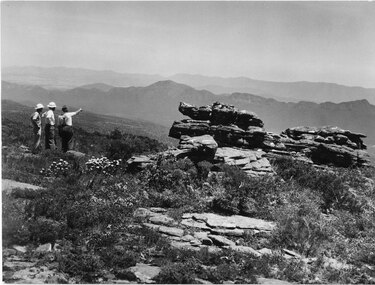 Halls Gap & Grampians Historical Society
Photograph - B/W, C 1960s
A track to the top of Mt William existed many years before, an all weather road was constructed in the early 1960s Not only did engineers and construction workers enjoy some spectacular scenery during "smokos" but so have thousands of tourists Some even experiencing the freezing gale force winds which greeting Major Thomas Mitchell and his party in July 1836sPhoto shows 3 men looking over to Wonderland Range from Mt William. Two men are wearing hard hats The third man a felt hat - he is pointing to a point in the distanceWMT (Wimmera Mail Times}access routes, walking track, roads, mount william -
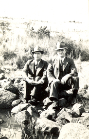 Federation University Historical Collection
Photograph - Black and White, Frank Wright and Charlie, Smeaton, 1940, March 1940
Frank Wright was a renown resident of Smeaton, where he was born on 2 August 1901. He lived at Laura Villa, and attended Smeaton State School. His father William was a gold miner and his mother's name was Sarah. Their family won many singing and instrumental awards. Frank was tutored by Percy Code and was awarded a gold medal for the highest marks in the ALCM examinations in the British Colonies at the age of seventeen years. He became the Australian Open Cornet Champion by the age of eighteen. A year later, Frank conducted the City of Ballarat Band, and later the Ballarat Soldiers’ Memorial Band. He formed the Frank Wright Frisco Band and Frank Wright and his Coliseum Orchestra. These bands won many South Street awards, and Frank as conductor won many awards in the Australian Band Championship contest. In 1933 Frank Wright sailed to England to conduct the famous St Hilda’s Band and was later appointed Musical Director of the London County Council, where he organized many amazing concerts in parks, in and around the London district. He was made Professor of Brass and Military Band Scoring and conducted at the Guildhall of Music and Drama. Frank was often invited to adjudicate Brass Band Championships around Europe, in Australia, including South Street and in New Zealand. The Frank Wright Medal at the Royal South Street competition is awarded to an individual recognized as making an outstanding contribution to brass music in Australia.Black and white photograph of two men dressed in suits and hats, sitting on rocks beside water. The background is a grassy paddock with a post and wire fence in the far distance. The man on the left is Frank Wright.Written in pencil on back - F.W. & Charlie, Smeaton, March 1940frank wright, brass band, conductor, smeaton -
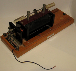 Federation University Historical Collection
Scientific Instrument, Induction Coil
An induction coil consists of two coils of insulated copper wire wound around a common iron core. One coil, called the primary winding, is made from relatively few (tens or hundreds) turns of coarse wire. The other coil, the secondary winding, typically consists of many (thousands) turns of fine wire. An electric current is passed through the primary, creating a magnetic field. Because of the common core, most of the primary's magnetic field couples with the secondary winding. The primary behaves as an inductor, storing energy in the associated magnetic field. When the primary current is suddenly interrupted, the magnetic field rapidly collapses. This causes a high voltage pulse to be developed across the secondary terminals through electromagnetic induction. Because of the large number of turns in the secondary coil, the secondary voltage pulse is typically many thousands of volts. This voltage is often sufficient to cause an electric spark, to jump across an air gap separating the secondary's output terminals. For this reason, induction coils were called spark coils. The size of induction coils was usually specified by the length of spark it could produce; an '8 inch' (20 cm) induction coil was one that could produce an 8 inch arc. (http://en.wikipedia.org/wiki/Induction_coil)A metal and plastic object on a timber stand. In an induction coil the distance between the plates is often used to measure the voltage of the spark since the air breaks down at 30 000 volts per centimetreballarat college of advanced education, scientific instrument, induction coil, scientific instruments, electricity -
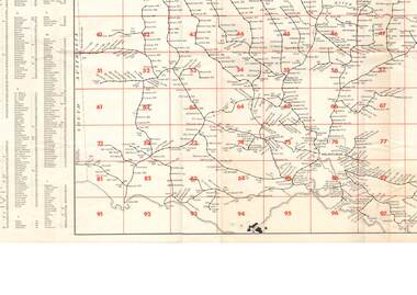 Bendigo Historical Society Inc.
Document - RAILWAY MAP: VICTORIAN LINES 1973
Railway map - Victorian lines 1973 with list of stations and grid reference for location of stations. Inset for detail of Ballarat and Melbourne lines and stations. Shows distance from Melbourne (Spencer Street station).railways, bendigo to melbourne, stations -
 National Vietnam Veterans Museum (NVVM)
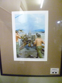
Photograph, 105 Field Battery Fire Mission
Colour photographic print in black frame with the light brown matt. Picture depicts personnel fireing the 105mm field artiliary surrounding them - a sandbag wall. Background - Hills in distance and sandbag shelter.My Vietnam Collection 105 Field battery fire mission, Vietnam 1969. Copyright Jed Robinson. Gift Horse Gallery - Original works by local & interstate artists and crafts people.105 field battery, photograph -
 Bendigo Historical Society Inc.
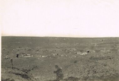
Photograph - ACC LOCK COLLECTION: B&W PHOTO OF A BATTLEGROUND WITH TOWNSHIP IN DISTANCE, PHOTOGRAPH, 1914-1918
Photograph, WW1, B&W photo of a desolate battleground showing gun positions and a township in the far left distance. Handwritten in pencil on the back Gun positions from the duckboards S985 114 114photo, photo, ww1, france, battleground -
 Bendigo Historical Society Inc.
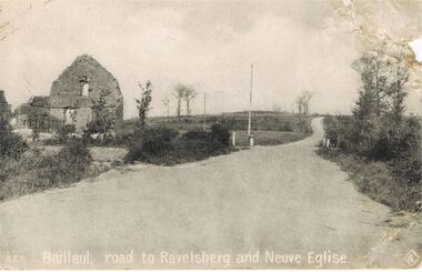
Postcard - ACC LOCK COLLECTION: BAILLEUL, ROAD TO RAVELSBERG AND NEUVE EGLISE, POSTCARD, 1914-1918
Postcard, WW1, B&W image of the road to Ravelsberg and Neuve Eglise at Bailleul. Ruined building at left of the road winding to the distance. Published by J.M.Hamilton & Coy. Sydney, Australia Copy AZ 6postcard, postcard, ww1, bailleul, ravelsberg, neuve eglise, france -
 Tatura Irrigation & Wartime Camps Museum
Photograph, Goulburn Weir, 1890
Taken by photographer for State Rivers and Water Supply Commission.Medium sized black and white photograph. View from south of weir under construction Two carpenter's trestles foreground Trees in mid distance background Canoe in middle dry channel in foregroundvictoria state rivers and water supply commission, goulburn weir -
Tatura Irrigation & Wartime Camps Museum
Photograph, 13/04/1918
Taken by photographer for State Rivers and Water Supply Commission.Medium sized black and white photograph. Eildon Weir / Original structure 1918 / Rock and earth fill dam wall / concrete spillway (lower left) / Water middle distance / hills beyondgoulburn weir, victorian state rivers and supply commission -
Tatura Irrigation & Wartime Camps Museum
Photograph, Wacker Rammer - Irrigation, 1957
Taken by photographer for State Rivers and Water Supply Commission.Medium sized black and white photo. Man using equipment(Wacker Rammer), to repair a channel break. Water foreground, Dethridge Wheel and concrete and earthen bank mid distance. Trees on horizon.On back: "A Wacker Rammer being used to repair a channel break."victoria state rivers and water supply commission, wacker rammer -
 Hume City Civic Collection
Photograph, Early 1980's
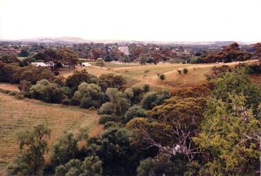
A coloured photograph of Cornish Street, looking west taken from Horne Street, with an avenue of pine trees on either side of the road. There is a roundabout at the first intersection and Mt. Holden can be seen in the distance.cornish street, horne street, mt. holden, george evans collection -
 Hume City Civic Collection
Photograph, c 1980s
The photograph although recently taken shows the original settled area in Sunbury, which included Goonawarra Vineyard and Macedon Street which was once the business centre of Sunbury township before the railway was established.A coloured photograph of Sunbury Township looking west from above Jacksons Creek and Goonawarra Winery. Macedon Street can be seen in the middle distance and Mt. Holden and Burke Hill are across the skyline.sunbury township, mt. holden, burke hill, francis, james goodall, barnier, john, jacksons creek, goonawarra winery, george evans collection -
 Southern Sherbrooke Historical Society Inc.
Photograph - Aura, Menzies Creek
Photo taken from the Menzies Creek railway station. St. Cuthberts Church is seen in the distance with a dirt road winding past and up hills with trees. In the foreground there are flower bushes and other shrubs. -
 Southern Sherbrooke Historical Society Inc.
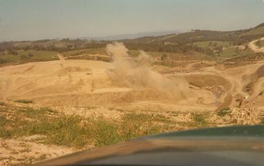
Photograph - Colour photograph, Cardinia Reservoir construction
Colour photograph of blasting works during the construction of the Cardinia Reservoir, Narre Warren East, in the 1970s. Plumes of dust rise from the orange sand and rock. In the distance low treed hills are visible. -
 Kew Historical Society Inc
Photograph - Victorian Canoe Club, Old Cerberus, 1930
Canoeing on the River Yarra at Melbourne was an important and widespread recreational pursuit for Melbournians, especially in the first half of the twentieth century. The Victorian Canoe Club was formed in 1912 at a meeting in Melbourne and its first committee elected in the same year. Records indicate that the Club continued into at least the 1950s .The photos in this album are historically and socially significant as a record of recreational activities in the first half of the twentieth century. A number of photographs in the album provide views of sections of the Yarra, as well as areas in regional Victoria, that may otherwise be unavailable.One of 12 sepia [faded] photographs of members of the Victorian Canoe Club. This photo is a distance shot of the HMAS Cerberus, which was sunk at Black Rock, Melbourne in 1926 to act as a breakwater for small craft."Old Cerberus"victorian canoe club, travel -- 1930s, canoeing, hmas cerberus -
 Kew Historical Society Inc
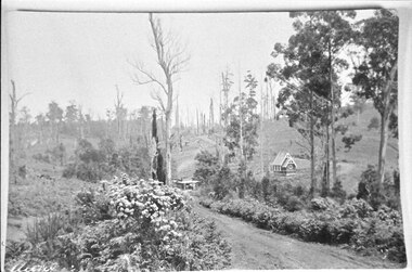
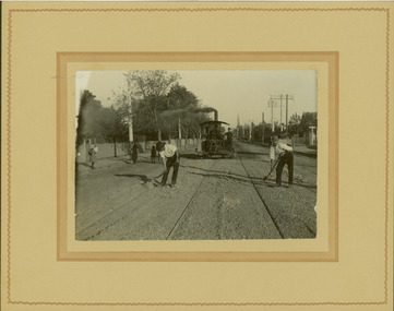
Photograph - Electric tram line construction in Cotham Road, Kew, E.J. Dower, 1913
One of a series of photographs, taken by Edgar James Dower in the second decade of the twentieth century. Born and raised in Olinda, his family later moved to Surrey Hills. He worked as an adult as a clerk in the city office of the Metropolitan Gas Company, and in his role as a 'collector', he was able to photograph scenes including the construction of tramlines and associated buildings in Kew, Hawthorn, Camberwell and Surrey Hills. Later he established a real estate agency with his brother - the E.J. Dower Real Estate Agency, Dandenong Office.The image is an historically significant record of the development of transport infrastructure which was used to connect Victorians in the first two decades of the twentieth century. This development resulted from increases in population and the consequent extension of Melbourne's suburbs. The photographs, both individually and collectively, richly detail the labour of workers and the tools and machinery used to create and extend Melbourne's tram network in the years preceding and during World War 1.Digital copy of an original mounted photograph depicting construction of a new electric tramline in Cotham Road, Kew. The photo shows workers and a steamroller. The spire of the Kew Presbyterian Church can be seen in the distance.Annotated verso: "Preparing for electric trams / Cotham Road Kew / Taken near Barrington Avenue / Taken by E.J. Dower / 1913"theme --- travelling by tram, theme -- connecting victorians by transport and communications, cotham road -- kew (vic.), trams -- kew (vic.) -
 Sunbury Family History and Heritage Society Inc.
Photograph, Gellibrand Hill
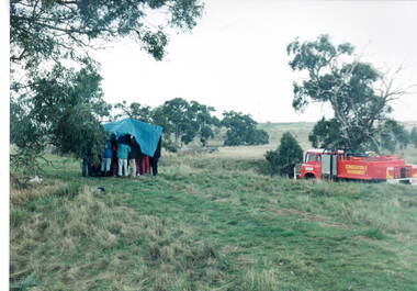
The students from Bulla Primary School were enjoying a tree-planting excursion at Gellibrand Hill and while they were taken for a ride around the park by the park ranger, the entire group were caught in a sudden shower of rain and had to take shelter under a large tarpaulin.A non-digital coloured photograph of children huddled under a large waterproof sheet to shelter from a sudden shower of rain with the truck which they were all on is parked a short distance from them.gellibrand hill, school excursions, bulla primary school -
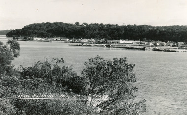
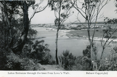
 Lakes Entrance Historical Society
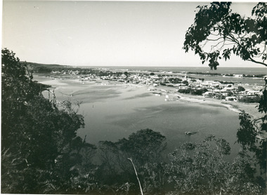
Photograph - Township, 1955
Also black and white postcard, similar view, titled Lakes Entrance through the trees from Lovers Walk. Bulmer copyright.Black and white photograph of a view from Kalimna Heights overlooking township. Shows North Arm, Marine Parade, Cunninghame Arm and sand hummocks with Bass Strait in distance. Lakes Entrance Victoriatownship, waterways -
 Lakes Entrance Historical Society
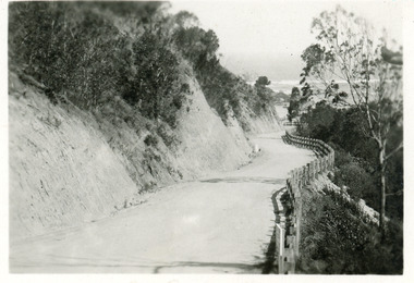
Postcard - Princes Highway Kalimna, 1920c
Black & white small format postcard of the Princes Highway at Kalimna. It shows the gravel road between the steep road cutting and post & rail fence. Bass Strait in distance. Lakes Entrance Victoriaroads and streets, fences, waterways -
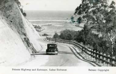 Lakes Entrance Historical Society
Postcard - The Entrance, Bulmer H D, 1930c
Black and copy 9 x 13.5, has inscription 'Princes Highway and Entrance, Lakes Entrance', ink spill on photo top right hand areaTinted small format postcard of the Princes Highway winding around Jemmys Point, between the steep road cutting and post and rail fence, entrance to Gippsland Lakes in the distance. Lakes Entrance Victoria waterways, roads and streets, vehicles -
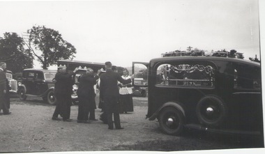 Sunbury Family History and Heritage Society Inc.
Photograph, 20 June 1933
The funeral recorded was that of Michael Ford which took place on the 20 June 1933 at Sunbury. He resided in Union Road Ascot Vale but was buried at Sunbury Cemetery. He was sixty-five years old. He was buried in the Roman Catholic section H plot 21 with two others in plots 22 an 23. His burial number was 2754. The registrar was W&W Lang and the undertaker was E H King. Apparently there is no memorial on the grave.Sunbury Cemetery was one of the earliest cemeteries to be established in the district.A non-digital black and white photograph of a hearse in a cemetery, with six pall bearers carrying a coffin to a grave site while a priest looks on. There are two other cars a short distance from the group.sunbury cemetery, burials, ford, michael. -
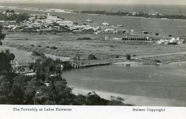 Lakes Entrance Historical Society
Postcard - Lakes Entrance, Bulmer H D, 1935
Marine Parade has not yet been formed through the low lying marshy area adjacent to North Arm. Very little vegetation on Eastern end of hummocks.Black and white postcard of the western end of Lakes Entrance,showing a glimpse of the North Arm bridge, town situated adjacent to Cunninghame Arm, sand hummocks and ocean in distance. Lakes Entrance VictoriaThe Township at Lakes Entrancetownship, waterways, bridges, hotels -
 Lakes Entrance Historical Society
Postcard - Lakes Entrance, Bulmer H D, 1950
Black and white postcard of the township of Lakes Entrance, taken form the south bank of Cunninghame Arm, showing the boat haven, buildings along Esplanade, and the Kalimna escarpment in the distance. Lakes Entrance VictoriaLakes Entrance from Ocean Beachtownship, waterways -
 Lakes Entrance Historical Society
Postcard - Township, 1935 c
Black and white photograph of a view from Kalimna Heights overlooking township. Shows North Arm, Marine Parade, Cunninghame Arm and sand hummocks with Bass Strait in distance. Lakes Entrance Victoriatownship, waterways -
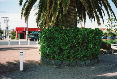 Lakes Entrance Historical Society
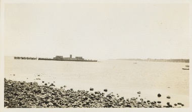
Photograph - Post Office, LERHS, 1999c
Paving was completed November 1993.Colour photograph of the forecourt of the Post Office Jetty, showing paved area, palm tree in circular garden. Norfolk Island pine in distance. Post Office over the road. Lakes Entrance Victoriawaterfront, postal services -
Clunes Museum
Book, WESTON ARTHUR BATE, LUCKY CITY - THE FIRST GENERATION AT BALLARAT: 1851 - 1901
IN 1854, ATTRACTED TO THE AREA BY WORLD FAMOUS GOLD DISCOVERIES, A EUROPEAN ARTIST SKETCHED AND ABORIGINAL AT WORK I THE FOREST AT WARRENHEIP NEAR BALLARAT...GREEN FABRIC COVER WITH GOLD LETTERING ON SPINE, COMPLETE WITH DUST COVER WHICH DISPLAYS A COLOURED ENGRAVING OF NINE PEOPLE IN A LANDSCAPE OF HILLS AND STREETSCAPE IN THE DISTANCE (AN ILLUSTRATION OF BALLARAT FROM BLACK HILL) non-fictionIN 1854, ATTRACTED TO THE AREA BY WORLD FAMOUS GOLD DISCOVERIES, A EUROPEAN ARTIST SKETCHED AND ABORIGINAL AT WORK I THE FOREST AT WARRENHEIP NEAR BALLARAT...the first generation of ballarat 1851-1901, gold fields of central victoria -
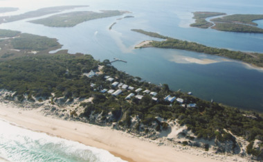 Lakes Entrance Historical Society
Photograph - Gippsland Lakes, 2005 c
Colour aerial photograph of Ocean Grange on the Gippsland Lakes ocean beach ninety mile beach in foreground Cresent Island channel through to Lake King Raymond Island in distance Paynsville Victoriaaerial photograph, settlement, gippsland lakes -
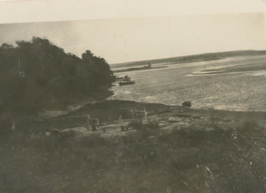 Lakes Entrance Historical Society
Postcard - Postcard/Cross Landing, 1910c
Paired with image 03733.1 for display at 150 years Lakes Entrance 1858 to 2008 held in October 2008Black and white postcard of lake foreshore at Cross Landing showing framework for drying fishing nets near shoreline jetties over water near steep shoreline in distance Lake Tyers Victoriaocean, topography, fishing industry