Showing 1383 items matching "divided"
-
 Flagstaff Hill Maritime Museum and Village
Card Holder, c. 1854 - 1957
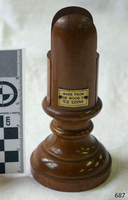
This wooden cardholder has been made from the wood of the screw steamer S.S. Edina, most probably after she was broken up in 1957, but could have been made after one of several renovations during her lifetime. The slotted design of the cardholder allows a card to stand vertically and the base is made wider to stableise the holder. It could be used for holding items such as place cards, menus, table numbers. ABOUT THE S S EDINA The three masted iron screw steamer SS Edina was built in Glasgow, Scotland, in 1854 by Barclay and Curle. She was adorned with the figurehead of ‘fair maid of Judea’. The many years of service made SS Edina famous worldwide as the longest serving screw steamer. (The term screw steamer comes from being driven by a single propeller, sometimes called a screw, driven by a steam engine.) SS Edina’s interesting history includes English Chanel runs, serving in the Crimean Ware carrying ammunition, horses and stores to the Black Sea, and further service in the American Civil War and later, serving in the western district of Victoria as well as in Queensland and carried gold, currency and gold prospectors Australia to New Zealand. SS Edina had the privilege of being an escort vessel to H.R.H. the Duke of Edinburgh during his visit to Australia in 1867. In March 1863 SS Edina arrived in Port Phillip Bay, Melbourne, and was bought by Stephen Henty, of Portland fame, to work the cargo and passenger run from Melbourne – Warrnambool – Port Fairy - Portland. After a short time of working the run from Australia to New Zealand, with passengers and cargo that included gold and currency, she returned to her Melbourne - Warrnambool – Port Fairy run, with cargo including bales of wool produced in the western district of Victoria. The Warrnambool Steam Packet Company purchased SS Edina in 1867; she was now commanded by Captain John Thompson and Chief Engineer John Davies. She survived several mishaps at sea, had a complete service and overhaul, and several changes of commanders. In 1870 SS Edina was in Lady Bay, Warrnambool, when a gale sprung up and caused a collision with the iron screw steamer SS Dandenong. SS Edina’s figurehead was broken into pieces and it was not ever replaced. SS Edina was re-fitted in 1870 than was used as a coastal trader in Queensland for a period. She was then brought to Melbourne to carry cargo and passengers between Melbourne and Geelong and performed this service 1880-1938. During this time (1917) she was again refitted with a new mast, funnel, bridge and promenade deck, altering her appearance. In 1938, after more collisions, SS Edina was taken out of service. However she was later renamed Dinah and used as a ‘lighter’ (a vessel without engine or superstructure) to be towed and carry wool and general cargo between Melbourne and Geelong. In 1957, after 104 years, the SS Edina was broken up at Footscray, Melbourne. Remains of SS Edina’s hull can be found in the Maribyrnong River, Port Phillip Bay. [Reference: A Brief Review of Steam Navigation in Victoria; C Dickson Gregory; Centenary Maritime Exhibition catalogue, 1934; published by Shiplovers' Society of Victoria Dandenong, Passengers in History, http://passengersinhistory.sa.gov.au/node/924034 Edina, Victorian Heritage Database VHR S199 http://vhd.heritage.vic.gov.au/shipwrecks/heritage/199 SS Edina, Coastal Trader and Passenger Ship 1853-1938, Museum Victoria Collections, https://collections.museumvictoria.com.au/articles/6227 SS ‘Edina’ – the Longest Serving Screw Steamer in the World, POI Australia, https://poi-australia.com.au/ss-edina-the-longest-serving-steamer-in-the-world/ ]This card holder is made from wood from the SS Edina and is significant for its association with that vessel. The SS Edina is heritage listed on the Victorian Heritage Database VHR S199. She had endeared herself to the people of Port Phillip Bay as a passenger ferry, part of their history and culture. She played a significant role in the Crimean War, the American Civil War and the gold rush in New Zealand. She also served western Victoria for many years in her cargo and passenger runs. The SS Edina is famous for being the longest serving screw steamer in the world. After spending her first nine years overseas she arrived in Melbourne and her work included running the essential service of transporting cargo and passengers between Melbourne and the western Victoria ports of Warrnambool, Port Fairy and Portland. The SS Edina was purchased in the late 1860’s by local Warrnambool business, the Warrnambool Steam Packet Co. and continued trading from there as part of the local business community. The SS Edina’s original ‘fair maid of Judea’ figurehead was broken to pieces in a collision with another vessel (the SS Dandenong) in a gale off Warrnambool, Victoria, in 1870. Card holder, made from the wood from the SS Edina (screw steamer ship). Holder is cylindrical shape, wider turned wood base. Top is divided with a space in the centre tor inserting a card. Rectangular metal plaque, gold coloured, has a printed inscription within black border. Made c. 1854 - 1957.Printed in black lettering on gold coloured plaque "MADE FROM / THE WOOD OF / S.S. EDINA"warrnambool, shipwrecked coast, flagstaff hill, flagstaff hill maritime museum, maritime museum, shipwreck coast, flagstaff hill maritime village, shipwrecked artefact, barclay & curle, figurehead 'fair maid of judea', centenary maritime exhibition 1934, a brief review of steam navigation in victoria, pleasure steamer edina, trade and travel late 19th and early 20th century, trade melbourne to geelong, screw steamer edina, coastal trader edina, lighter dinah, cargo carrying for cremean war, cargo carrying for american civil war, passenger and trade in western district of victoria, export gold and currency and gold diggers to new zealand, export vessel to h r h the duke of edinburgh, melbourne - warrnambool - port fairy - portland cargo run, warrnambool steam packet company, stephen henty, captain john thompson, chief engineer john davies, lady bay warrnambool, lighter edina, shipping victoria, port phillip bay steamers, steamship great britain, edina, vhr s199 victorian heritage database, card holder, menu holder, table number holder, souvenir of the ss edina -
 Bendigo Historical Society Inc.
Document - BENDIGO SALEYARDS COLLECTION: REWEIGHS OF PIGS
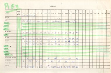
Eleven pages titled Reweighs (Pigs). One page is dated 13/9/90. Pages are divided into columns with the agents names, Total No. Weigh, Columns titled Lots and TW are repeated across the page. Agents are: Dalgety, Elders, Hill, McGregor, M & T, McKean, Nevins, Nuttall, Rodwell, Vains, V.P.C., Webster & Co,bendigo, council, cattle markets, bendigo saleyards collection - reweighs of pigs, dalgety, elders, hill, mcgregor, m & t, mckean, nevins, nuttall, rodwell, vains, v.p.c., webster & co -
 Bendigo Historical Society Inc.
Photograph - VIEWS OF BENDIGO: NORTH OLD CHUM CLAIM, c. 1870's
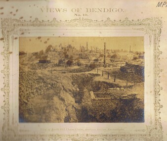
Photograph 10. Sepia photograph of View of North Old Chum Claim, showing surface Excavations. Printed below photograph: J.W. Forbes, Agent, Lansell's No. 180 Claim, Welch Expo. 'New Chum and Victoria Company's Quartz Crushing Battery', 'the dividing range between Happy Valley, Victoria Hill and Iron Bark'. Nicholas CaireN J Cairetopic, mining, old chum mine -
![Document - HANRO [AUSTRALIA] KNITTING MILLS](/media/collectors/4f729f7e97f83e03086018f4/items/6684d58216337b271b28e505/item-media/6685018a16337b271b296645/item-fit-380x285.jpg) Bendigo Historical Society Inc.
Bendigo Historical Society Inc.Document - HANRO [AUSTRALIA] KNITTING MILLS
Un-issued Hanro [Australia] Knitting Mills Limited 100 share scrip No 1661. Authorised Capital £400,000 divided into 15,000 cumulative preference shares £1 each, 178,332 ordinary shares of £1 and 206,668 unclassified shares of £1. Registered Office 163-175 Hargreaves Street Bendigo. Miss Parry hand written on reverse.bendigo, industry, knitting mill, hanro knitting mills {australia] -
 Tatura Irrigation & Wartime Camps Museum
Box - Sewing, 1940's
Handmade by internees at WW2 Camp 3, TaturaHandmade varnished wooden sewing box with concertina-like opening sections/drawers. Two at the top having doors and cut out handles. One top drawer is divided into 2 sections and has a picture of a Kookaburra on its door, the other has 4 sections and a picture of a koala and baby on the door. Corners of sections are dovetailed and doors hingedsewing box, wood, liebeskind, wagner, camp 3, tatura, ww2 camp 3, domestic, sewing -
 Chiltern Athenaeum Trust
Slide Rule, Circa 1950
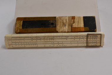
Slide rules were commonly used prior to the invention of the calculator. The Slide rule was used for performing multiplication, division and other scientific functions up through the 1960s and prior to the development of the electronic calculator. Used by Frank Smythe, engineer. Used up to the 1960's prior to the invention of the electronic calculator. Metal rule, hard cardboard case. The slide rule consists of two divided scales, one fixed and one movable, and a sliding window called a cursor. The Slide rule was used for performing multiplication, division and other scientific functions up through the 1960s and the development of the electronic calculator. System Darmstadt dmake, sun Hemm, Japan. "F. SMYTH" is annotated on the slide rule cover. slide rule, circa 1950 slide rule, trade measurements and calculations slide rule -
 Ballarat Tramway Museum
Postcard, Rose Stereograph Co, Charing Cross, Bendigo, mid 1900's
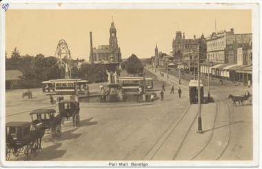
Demonstrates aspects of the development of the Bendigo tramways by ESCo prior to undertaking the Ballarat system. Yields information about Charing Cross soon after the electric tramway was opened.Black and White postcard, early 1900's view of Charing Cross, Bendigo looking towards the north, Pall Mall. Has three tram cars in the view, the fountain, centre poles, horse drawn cabs and vehicles, a poppet head and building on the east side of the Pall Mall. Divided back postcard with areas for message, address, and the stamp. Has "67)" in the top left hand corner of the back of the card, a circled "13" crossed out, "early 1900's" in ink. In the top right hand corner "$8" in pencil. On the front of the card has "67)" in the top left hand corner in ink.trams, tramways, bendigo, pall mall, charing cross, tram 4 -
 Ballarat Tramway Museum
Postcard, Ballarat Tramway Museum (BTM), former Melbourne tram at Bungaree, 2014
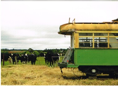
Postcard of a former Melbourne tram with the cabin front removed stored at Bungaree with some cows in the background. Photo taken during 2004. Printed in Ballarat by???. On the rear has the words "Ballarat Tramway Museum / Limited Edition 1/50, c BTM 2014" Has a divided back with a 8mm thick black line on the right hand side.trams, tramways, bungaree, btm, stored trams, tram 14, tram 40, tram 38 -
 Bayside Gallery - Bayside City Council Art & Heritage Collection
Plaque, Royal coat of arms of the United Kingdom
This plaque, along with the Commonwealth Coat of Arms 0000-732, were previously on display in the Brighton City Council's municipal chambers. Oil paint on plywood. Royal coat of arms on black ground showing the central shield divided into four quarters flanked by the English Lion and Scottish Unicorn, surmounted by the Royal Crown. Below the shield appears the motto of the English monarchs ‘Dieu et mon droit’ (God and my right). There are four holes at each corner of the board.royal coat of arms, coat of arms, plaque, united kingdom, brighton city council, brighton -
 Wodonga & District Historical Society Inc
Banner - Souvenir Banner 2/23rd Battalion - Albury's Own
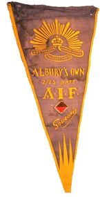
Established at Victoria Barracks, in Melbourne, in June 1940, the 2/23rd Battalion was raised as part of the all-volunteer Second Australian Imperial Force and assigned to the 26th Brigade. Under the command of Lieutenant Colonel Bernard Evans, a small cadre of experienced personnel drawn from Victorian Militia units were concentrated at Victoria Barracks prior to the battalion headquarters being relocated to Albury, New South Wales, where a large number of volunteers were completing their recruit training at the 4th Recruit Training Battalion. Upon the conclusion of this course, the recruits were posted to the 2/23rd and the battalion – over 900 strong– moved to Bonegilla, Victoria, just across the border, where more complex collective training was completed prior to departure overseas. A large majority of the battalion's initial intake of volunteers came from the Albury–Wodonga region and as a result, the 2/23rd became known as "Albury's Own"This item is part of a collection of items owned by Athur Lock, a member of the 2/23rd Battalion, an all-volunteer Second Australian Imperial Force which served as part of the garrison during the Siege of Tobruk, then at El Alamein, New Guinea and Borneo. It has particular local significance as the battalion was know as "Albury's Own" because a large majority of the battalion's initial intake of volunteers came from the Albury–Wodonga region.A souvenir banner representing the 2/23rd Battalion - Albury's Own. The banner incorporates the insignia of the Commonwealth of Australia Military Forces. It also includes the Unit colour patch which is a lozenge shape, divided into brown over red, with a grey trim. This patch was used from 1940 to 1942 when the patch representing service at Tobruk was introduced. world war 11, 2/23rd battalion, albury's own, arthur lock -
 Lakes Entrance Historical Society
Photograph - Esplanade Lakes Entrance, Holding M, 1994
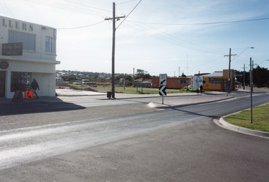
Date made May 1994Colour photograph of the old carnival site on Esplanade. It shows a corner of Something Special Jewellers on left, preparations for construction of Safeway in distance, C H Daniels Hooker Real Estate Agency on right, part of the road and Princes Highway, divided by traffic island. Entry to lakeside parking bay in right foreground. Lakes Entrance Victoriatownship, retail trade, roads and streets -
 Melbourne Tram Museum
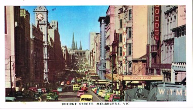
Postcard, Rose Stereograph Co, "Bourke Street Melbourne Vic", late 1950's or early 1960's
Postcard photo of Bourke St looking east from near Queen St with a number of trams in the distance view. Has the Thomas Cook, Hicks and other buildings in the view. Late 1950's or early 1960's. Divided back with places for stamp, address, correspondence and details with makers details "Rose colour card 119"trams, tramways, bourke st, queen st -
 Melbourne Tram Museum
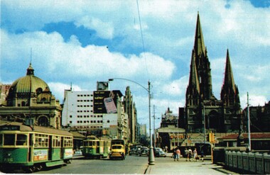
Postcard, Nu-color-Vue, Princes Bridge with Flinders St Station, c1950
Postcard photo of Princes Bridge with Flinders St Station, St Pauls Cathedral and Princes Bridge station with trams 896 and a W2 crossing the bridge southbound. Kodak photo but register poor. Appears c1950 given the vehicles. Divided back with places for stamp, address, correspondence and details. Nucolorvue Productions L10 with a Kodachrome productions note.trams, tramways, princes bridge, st paul's cathedral, flinders st station, tram 896 -
 Melbourne Tram Museum
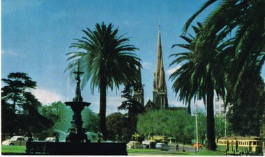
Postcard, Vic Post Card, gardens at the south end of the Victorian Parliament building, c1950
Postcard photo of the gardens at the south end of the Victorian Parliament building, showing the Stanford Fountain with Spring St in the background and the spires of St Patrick's Cathedral. Has two W2's in Spring St. Divided back with places for stamp, address, correspondence and details with makers details "Vic Post Card"?, Series 1/18 - c1950/trams, tramways, spring st, parliament, st patricks -
 Melbourne Tram Museum
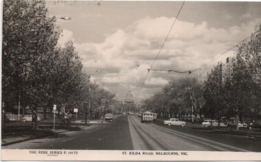
Postcard, Rose Stereograph Co, "St Kilda Road, Melbourne Vic", c late 1950s
Postcard - Black and White - Rose Series P14172, titled "St Kilda Road, Melbourne Vic" - looking south with the Shrine of Remembrance in the background. W2 328 northbound. Has a number of vehicles in the view - late 1950 Holden station wagon. On the rear - has a divided back, and "A Real Photograph" " & Produced in Australia" and the Rose logo and address details.On the rear has the stamp of Graeme S Breydon - see image i2.trams, tramways, melbourne, st kilda rd, shrine of remembrance, tram 328 -
 Melbourne Tram Museum
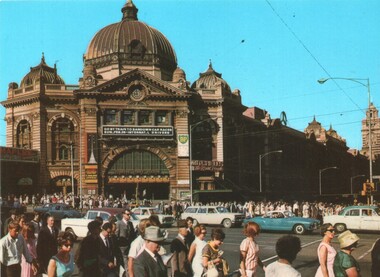
Postcard, Murfett Publishers, "Flinders Street Station", early 1960's
Postcard - Colour - National View by Murfett Publishers, BP1055 of the front of Flinders St Station, early 1960's. Many people crossing the intersection - no trams. Has a sign on the station, advertising car races at Sandown Park. On the rear - has a divided back, with National View by Murfett Publishers and logo, description of the station and number BP1055On the rear has the stamp of Graeme S Breydon - see image i2.trams, tramways, swanston st, flinders st station, flinders st -
 Melbourne Tram Museum
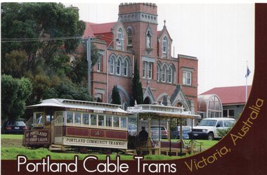
Postcard, Blue Lake Printworks, Portland Cable tram set, 2005?
Full colour postcard featuring the Portland Cable tram set (trailer 95) in front of the Bayview College in Bentnick St Portland. Has the name on front of the card and on rear some details of the operation. Produced by Blue Lake Printworks of Mount Gambier. Photo Kelvin Ruge. Divided back postcard with space for address, stamp and message.trams, tramways, cable trams, portland, museum, tram 95 -
 Melbourne Tram Museum
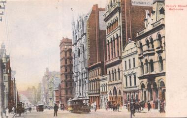
Postcard, WTP, "Collins Street Melbourne", mid 1900's?
Divided back postcard featuring a coloured image of Collins St near Queen St with a cable tram climbing the hill and many of the historic buildings in the background. Card has the title on the right hand side. Tram has the destination of Port Melbourne Rear has space for stamp, address, message. Notes that it was printed in Germany, published by WTP.trams, tramways, cable trams, collins st, queen st, melbourne, port melbourne -
 Melbourne Tram Museum
Postcard, "St Paul's Cathedral Melbourne", 1900's
Postcard - silver finish known as "Collotype" - view of St Paul's Cathedral at the corner of Swanston and Flinders St, prior to the construction of the spires in mid 1920's. Photo c1900's. Card titled "St Paul's Cathedral Melbourne" Postcard has a divided back with space for stamp, address and correspondence. In the top centre is a start with an "O" in the centre.trams, tramways, swanston st, flinders st, st paul's cathedral -
 Melbourne Tram Museum
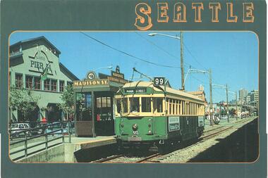
Postcard, Smith Western Co. of Tacoma, "Seattle", 1990's
Postcard - full colour, Divided back type of former Melbourne tram 512 running in Seattle, show destination of Main St, route 99 with the Pier 54 building in the background. At the Madison St stop. The rear has details of the location of the publisher (Smith Western Co. of Tacoma), photographer Charles Van Pelt and where printed - Singapore.trams, tramways, seattle, w2 class, tram 512 -
 Melbourne Tram Museum
Postcard, Biscay Greetings, Princes Bridge from Batman Ave, mid to late 1980's
Colour postcard divided back - Biscay Greetings, series of featuring Princes Bridge from Batman Ave with the Arts Centre in the background. Image contained within a decorative oval. Back has space for name and address, stamp and a message and details of the postcard. Produced by Biscay Greetings, possibly mid to late 1980's. Card No. BG216trams, tramways, princes bridge -
 Melbourne Tram Museum
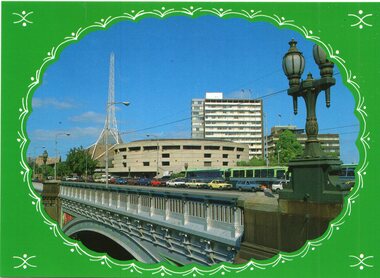
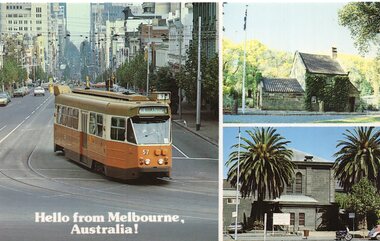
Postcard, Stewart Postcards, three panel, featuring Z57 turning from Bourke into Spring, late 1980's
Colour postcard divided back, three panel, featuring Z57 turning from Bourke into Spring, Captains Cook cottage and old Melbourne Goal. Back has space for name and address, stamp and a message and details of the postcard. Produced by Stewart Postcards SV014 Has "Hello from Melbourne Australia!" in the bottom left hand corner.trams, tramways, bourke st, z class, melbourne, tram 57 -
 Melbourne Tram Museum
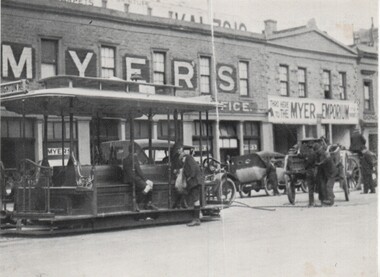
Postcard, Myer, Myer Lonsdale St Warehouse with a grip car, early 1980's
Black and white postcard, divided back with a photo of the Myer Lonsdale St Warehouse with a grip car in front prior to the construction of the 11 storey store. Card dated c1920. Has a number of motor vehicles and horse drawn vehicles in the view. Has space for a stamp on the rear and has card details and some notes about Myer itself.On rear in pencil "Purchased 21/6/1983"trams, tramways, lonsdale st, cable trams, grip tram, myer -
 Bendigo Historical Society Inc.
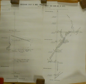
Plan - MARKS COLLECTION: UNDERGROUND SURVEY OF MINES SANDHURST NEW CHUM LINE OF REEF
Plan, divided into two sheets, on top of sheet Underground survey of mines Sandhurst, New Chum Line of Reef. Surveyed by Caleb Thomas under the direction of Charles W. Langtree, Acting Secretary for Mines and Water Supply and Acting Chief Mining Surveyor for the Colony of Victoria. Drawn by Arthur Everett, Mining Department, Melbourne, 1884.bendigo, mining, new chum line of reef -
 Geoffrey Kaye Museum of Anaesthetic History
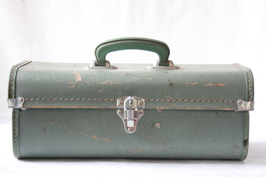
Equipment - Kit, Resuscitator, Commonwealth Industrial Gases Ltd, c.1960
Green case with lock at the front and plastic green handle on top with a manufacturer's label stuck on top. Inside the case is divided into three separate section, one containing a clear plastic mask with latex cushioning, the second containing a grey resuscitation bulb and the third containing a smaller clear plastic mask with latex cushioning, still in original packaging.Green manufacturer's label on top of case: THE CIG AIR-VIVA RESUSCITATOR Inside case: Original label 'Operating Instructions'ambu, resuscitator, cig air-viva -
 Flagstaff Hill Maritime Museum and Village
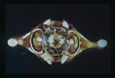
Accessory - Diamond ring, about 1855
In 1975, 120 years after the sailing ship Schomberg was wrecked, Flagstaff Hill divers (Peter Ronald, Colin Goodall and Gary Hayden) found an ornate communion set amongst the wreckage. The set comprised a jug, ciborium, lid, chalice and plate. The items, apart from the lid, were then displayed at Flagstaff Hill Maritime Village. The lid had etchings that did not match the chalice and sat in storage for several years. Then in 1978, while the marine concretion inside the lid was being examined, a surface layer came loose and revealed a glint of gold that was assumed to be a piece of brass. The layers of concretion were carefully removed and a ring-like band emerged. Further treatment exposed a 'large faceted stone in an intricate gold setting. Weeks later a detailed examination estimated the value of the ring, known as the Schomberg Diamond, to be $7000. When the Schomberg was launched in 1855, she was considered the "Noblest” ship that ever floated on the water. Schomberg's owners, the Black Ball Line had commissioned the ship for their fleet of passenger liners. She was built by Alexander Hall of Aberdeen at a cost of £43,103 and constructed with 3 skins. One planked fore and aft and two diagonally planked, fastened together with screw-threaded trunnels (wooden rails). Her First Class accommodation was simply luxurious with velvet pile carpets, large mirrors, rosewood, birds-eye maple and mahogany timbers throughout, soft furnishings of satin damask, an oak-lined library with a piano. Overall she had accommodation for 1000 passengers. At the launch, the Schomberg's 34-year-old master, Captain 'Bully' Forbes, had promised to reach Melbourne in sixty days stating, "with or without the help of God." Captain James Nicol Forbes was born in Aberdeen in 1821 and rose to fame with his record-breaking voyages on the famous Black Ball Line ships; Marco Polo and Lightning. In 1852 in the Marco Polo, he made the record passage from London to Melbourne in 68 days. Unfortunately there were 53 deaths on the voyage, but the great news was off the record passage by Captain Forbes. In 1854 he took the clipper “Lighting” to Melbourne in 76 days and back in 63 days, this record was never beaten by a sailing ship. He often drove his crew and ship to breaking point to beat his previous records. He cared little for the comfort of the passengers. On this, the Schomberg's maiden voyage, he was determined to break existing records. Schomberg departed Liverpool on her maiden voyage on 6th October 1855 flying a sign that read "Sixty Days to Melbourne". She departed with 430 passengers and 3000 tons cargo including iron rails and equipment intended to build the Melbourne to Geelong Railway and a bridge over the Yarra from Melbourne to Hawthorn. She also carried a cow for fresh milk, pens for fowls and pigs, 90,000 gallons of water for washing and drinking. She also carried 17,000 letters and 31,800 newspapers. The ship and cargo were insured for $300,000 a fortune for the time. The winds were poor as she sailed across the equator, slowing Schomberg's journey considerably. Land was first sighted on Christmas Day, at Cape Bridgewater near Portland, Captain Forbes followed the coastline towards Melbourne. Forbes was said to be playing cards when called by the third mate Henry Keen, who reported land about 3 miles off. Due in large part to the captain's regarding a card game as more important than his ship, it eventually ran aground on a sand spit near Curdie's Inlet (about 56 km west of Cape Otway) on 26th December 1855, 78 days after leaving Liverpool. The sand spit and the currents were not marked on Forbes's map. Overnight, the crew launched a lifeboat to find a safe place to land the ship’s passengers. The scouting party returned to Schomberg and advised Forbes that it was best to wait until morning because the rough seas could easily overturn the small lifeboats. The ship’s Chief Officer spotted the SS Queen at dawn and signaled the steamer. The master of the Queen approached the stranded vessel and all of Schomberg’s passengers and crew disembarked safely. The Black Ball Line's Melbourne agent sent a steamer to retrieve the passengers' baggage from the Schomberg. Other steamers helped unload her cargo until the weather changed and prevented the salvage teams from accessing the ship. Later one plunderer found a case of Wellington boots, but alas, all were for the left foot. Local merchants Manifold & Bostock bought the wreck and cargo but did not attempt to salvage the cargo still on board the ship. They eventually sold it on to a Melbourne businessman and two seafarers. In 1864 after two of the men drowned when they tried to reach Schomberg, salvage efforts were abandoned. In 1870, nearly 15 years after the wreck parts of the Schomberg had washed ashore on the south island of New Zealand. The wreck now lies in almost 9 meters of water and although the woodwork is mostly disintegrated the shape of the ship can still be determined due to the remaining railway irons, girders and the ship’s frame. A variety of goods and materials can be seen scattered about nearby. The actual lid in which the ring was found has not yet been completely identified and could belong to a coffee pot, sugar bowl or maybe a jug or something similar. Although all survived the wreck no-one came forward to claim the valuable diamond. The Schomberg Diamond is currently on display in the Great Circle Gallery. Flagstaff Hill Maritime Village along with the rest of the communion set. Other artefacts salvaged from the wreck include ship fittings and equipment, personal effects, a lithograph, tickets and photographs from the Schomberg. One of the Schomberg bells is in the Warrnambool Library.The Schomberg Diamond is particularly significant in that it played a crucial part in having the legislation changed to protect shipwrecks, with far tighter control over the salvaging of items from wreck sites. This ring is registered as Artefact S/105 in the Schomberg collection, the Schomberg collection as a whole is of historical and archaeological significance at a State level. Flagstaff Hill’s collection of artefacts from the Schomberg is also significant for its association with the Victorian Heritage Registered shipwreck (VHR S 612). The collection is of prime significant because of the relationship between the objects salvaged, as together they help us to interpret the story of the Schomberg. The collection as a whole is historically significant for representing aspects of Victoria's maritime history and its potential to interpret social and historical themes. A mid-Victorian gentleman's solitaire diamond dress ring with a Brazilian cut diamond (cushion cut), one and one-third carat set within an 18 carat yellow gold ring consisting of four claws within an open scroll setting and a divided scroll shank. Colour is classified as 'J', clarity SII. The setting is handmade. warrnambool, shipwrecked-coast, flagstaff-hill, flagstaff-hill-maritime-museum, maritime-museum, shipwreck-coast, flagstaff-hill-maritime-village, schomberg, shipwrecked-artefact, clipper ship, black ball line, 1855 shipwreck, aberdeen clipper ship, captain forbes, peterborough shipwreck, ss queen, ciborium, ring, schomberg-diamond, schomberg-ring, gentleman's ring, dress ring -
 Ballarat Tramway Museum
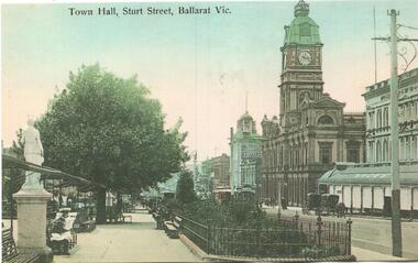
Postcard - copy, "Town Hall Sturt Street Ballarat Vic", c2000
Postcard of Sturt St looking East from about Doveton St with Shoppee Square, Snows store and the Town Hall in the view. Card reproduced for Sovereign Hill Gold Mining Township by Rose Stereograph Co. of Glen Waverley c2000. Divided back type with caption, production and the Rose Co. symbol on the rear.Yields information about the appearance of Sturt St following the introduction of electric trams in 1905 and has a strong association with the work of Sovereign Hill and Rose Stereograph Co.Postcard reproduction - full colour - Rose Stereograph Co.trams, tramways, sturt st, ballarat, esco, rose postcards, town hall, shoppee's square, snows -
 Bendigo Historical Society Inc.
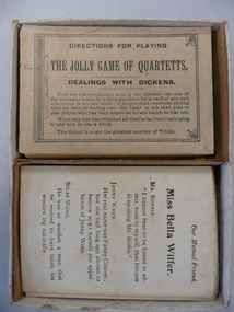
Leisure object - CARD GAME - QUARTETTS (DEALING WITH DICKENS)
Quartets is a dedicated deck card game with the object to collect 4 cards in a series, similar to Go Fish and Happy Families. Each pack originally contained 32 cards, divided into 8 groups of 4 cards, unlike a normal 52 pack of playing cards, but the number of groups changed from company to company.Card Game - Quartetts (Dealing with Dickens). Set of cards based on stories of Dickens (the 'suits' of this game). Appears to be a full set of cards (4 per suit.) Directions for playing are on a card. No manufacturer's name. dickens, dealings with dickens, card game, quartet -
 Kiewa Valley Historical Society
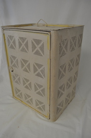
Safe Coolgardie, circa early 1900s
The harsh summer temperatures and the isolated rural environment(of the 1890's) provided the inventor of the "Coolgardie safe" (Arthur Patrick McCormick) with an idea to cool perishable foods by using water soaked "hessian" cloth to provide the "coolant" for the evaporation process to cool the inside temperature of the "safe". Items such as meat,cream/milk/butter and cool "drinks" are a few perishables that need cool environments , especially in isolated "ice free" locations. Cities during this time period had large "ice works" which delivered block ice to all areas that required a form of refrigeration. These ice blocks where held in early refrigerators to keep perishables cool to cold. This "Coolardie" safe was the next best thing for isolated rural households and travellers/campers/stockmen to provide a cooler environment for foodstuff affected by heat. Ice filled "esky" coolers and ice boxes are a modern day off shoot to the original Coogardie safe however they still rely on ice or frozen coolant bricks for cooling.This "Coogardie" safe is very significant to the Kiewa Valley and the Bogong High Plains because it represents not only the initiative thinking of the early settlers and communities but also the "primitive" solution to an everyday (1800s to 1930s) problem (before gas and electric run refrigerators) of keeping "perishables" at a low temperature and thereby prolonging their "shelf" life. This was before electricity and gas was available to the inhabitants of the Kiewa Valley and Bogong High Plains. Another cooling method for food was to have "water tight" containers dipped into the very cold streams running from the "cooler" alpine mountains and the Bogong High Plains. This however could not be carried out in all situations eg. fast flowing currents and locations away from streams. This "Coolgardie safe" is made from a medium grade steel enclosure and its appearance is of a perforated box with a wire handle and one side (long side) being a hinged "door" with a clasp securing "lock". There are air holes grouped into a small "boxed" pattern. Each "box" is divided by a crossed pattern, dividing the "holed" sections(4) into a diamond configuration of 49 small holes each. There are four sides (long) which have the perforations except for the base which does not. The base has an indentation with a loose "catch" tray to catch water spills. When in use the "box" is covered with a water "soaked" cloth. The wet cloth is used as "coolant" ie. fibers in the cloth hold the water droplets seep out evaporating the area and thereby (in mass) cooling the air inside the container.domestic refrigeration cabinets, coolgardie "safe", insect and vermin proof food containers, electric and gas free cold storage containers -
Eltham District Historical Society Inc
Document - Folder, Murphy, James and descendants
James Murphy was a mining surveyor involved with the Caledonia diggings. Contents Note from Ray Blake, 26 April 2000: Ms Murphy said her people had traditionally owned all of inner Melbourne, north to the Great Divide, West to Werribee River, East to Mt Baw Baw, South to Mordialloc Creek.Newspaper clippings, A4 photocopies, etcjames murphy