Showing 2059 items
matching hawthorn east
-
 Whitehorse Historical Society Inc.
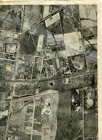
Map, Photo-map Ringwood A4A, 1945
Aerial photo covering approximately from Box Hill to Mitcham (West to East) and Springfield Road to Hawthorn Road (North to south).Aerial photo covering approximately from Box Hill to Mitcham (West to East) and Springfield Road to Hawthorn Road (North to south). Names of main roads inscribed.Aerial photo covering approximately from Box Hill to Mitcham (West to East) and Springfield Road to Hawthorn Road (North to south).aerial photographs, box hill, blackburn, nunawading, forest hill, mitcham -
 Whitehorse Historical Society Inc.
Map, Map of East and South eastern suburbs of Melbourne, 1930s
Map of suburbs of Melbourne from Kew to Ringwood and South Morang Station to East Oakleigh.Map of suburbs of Melbourne from Kew to Ringwood and South Morang Station to East Oakleigh.Map of suburbs of Melbourne from Kew to Ringwood and South Morang Station to East Oakleigh.blackburn, mitcham, hawthorn, box hill, doncaster, templestowe -
Whitehorse Historical Society Inc.
Book, A Journey through Melbourne's East, 2008
A Pictorial journey through the eastern suburbs from Hawthorn to Templestowe, Box Hill, Blackburn and Mitcham.A Pictorial journey through the eastern suburbs from Hawthorn to Templestowe, Box Hill, Blackburn and Mitcham, where Fletchers Real Estate has operated over the years since it began in Kew in 1919.A Pictorial journey through the eastern suburbs from Hawthorn to Templestowe, Box Hill, Blackburn and Mitcham.fletcher and parker, fletchers, real estate agents, box hill, blackburn, mitcham -
 Whitehorse Historical Society Inc.
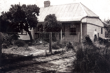
Photograph, Lowen family Home, 1/06/1920 12:00:00 AM
The home of Frederick & Julia Lowen was re-located in 1933 to allow Blackburn Road (which then ended in the vicinity of what is now Hawthorn Road) to be extended through to Burwood Road (now Burwood Highway). That section of Blackburn Road that now runs between Burwood Highway and High Street Road was originally Hewlett Road and from High Street Road to Princes Highway Was May Road.Black & white photo of the Lowen home at East Burwood in the mid 1920s. The lady on the right is presumed to be Julia Lowenlowen family home, east burwood -
Bialik College
Document (Collection) - Meg Rynderman Collection Box 2, Meeting Minutes Council and Executive 1993-1995
... Bialik College 429 Auburn Road Hawthorn East 3123 melbourne ...1990s, judaism, bialik college, governance1990s, judaism, bialik college, governance -
Bialik College
Document (Collection) - Meg Rynderman Collection Box 3, Council Meeting Minutes 1995-1997
... Bialik College 429 Auburn Road Hawthorn East 3123 melbourne ...governance, judaism, bialik college, 1990sgovernance, judaism, bialik college, 1990s -
Bialik College
Document (Collection) - Meg Rynderman Collection Box 5, Meeting Minutes Council and Executive Oct 1998- Nov 1999
... Bialik College 429 Auburn Road Hawthorn East 3123 melbourne ...judaism, governance, 1990sjudaism, governance, 1990s -
Bialik College
Document (Collection) - Meg Rynderman Collection Box 6, Meeting Minutes Council and Executive 1999-2000
... Bialik College 429 Auburn Road Hawthorn East 3123 melbourne ...governance, judaism, 1990s, 2000sgovernance, judaism, 1990s, 2000s -
Bialik College
Photograph (Item) - Circus Maximus Event at Bialik College
... Bialik College 429 Auburn Road Hawthorn East 3123 melbourne ...Sixteen developed photographs, showing a middle school audience in uniform enraptured with the clowns' actions of baton twirling, building a pyramid of people, and unicycle riding. 2001. Please contact [email protected] to request access to this record.Developer's mark indicate they were developed on 12 June 2001.2000s, judaism, bialik college, performance -
Bialik College
Functional object (Item) - Bialik Photograph album 1963-1971
... Bialik College 429 Auburn Road Hawthorn East 3123 melbourne ...Photograph album 1963-1971. Principals Mr I Ernest, Mr Heretz, Mr A Chowers. Includes photographs of speech days, bat mitzvah, school events, teacher portraits. Please contact [email protected] to request access to this record.Bialik Photograph album 1963-1971 1960s, 1970s, bialik college, judaism -
Bialik College
Album (Item) - "West Side Story Production", Bialik College, Theatre Production, 1998
... Bialik College 429 Auburn Road Hawthorn East 3123 melbourne ...1998 Bialik College West Side Story yearly musical production. Please contact [email protected] to request access to this record.1990s, judaism, musical, production -
Bialik College
Album (Item) - "The Visit" Bialik College, theatre production, 1998
... Bialik College 429 Auburn Road Hawthorn East 3123 melbourne ...1998 Theatre Production of "The Visit". Please contact [email protected] to request access to this record.theatre production, bialik college, judaism, 1990s -
Bialik College
Album (Item) - "Mikado", Bialik College, Theatre Production 199
... Bialik College 429 Auburn Road Hawthorn East 3123 melbourne ...1999 school musical production at Bialik College. Held at St Martins Youth Centre, South Yarra. Show dates August 20-31, September 1-2. Please contact [email protected] to request access to this record.1990s, bialik college, musical, theatre production, judaism -
Bialik College
Album (Item) - "A Stitch In Time", Bialik College, Theatre Production, 1996
... Bialik College 429 Auburn Road Hawthorn East 3123 melbourne ...Year 2 & 3 production for 1997, "A Stitch In Time". Performed on 6 November at the Stonnington Theatre, Deakin University, Toorak Campus, Malvern. Please contact [email protected] to request access to this record.1990s, theatre production, judaism, bialik college -
Bialik College
Album (Item) - "Phantom of the Auditorium", Bialik College, Theatre Production, 1995
... Bialik College 429 Auburn Road Hawthorn East 3123 melbourne ...Performed at Hawthorn Institute of Education by years 4, 5 & 6. One show on Wednesday 1 November 1995. Please contact [email protected] to request access to this record.1990s, judaism, theatre production, bialik college -
Bialik College
Album (Item) - "The Couch Potatoes", Bialik College, Theatre Production, 1994
... Bialik College 429 Auburn Road Hawthorn East 3123 melbourne ...Grades two and three production at Bialik College, 1004. One performance 29 November, at Stonnington Theatre, Deakin University, Malvern. No other details available.theatre production, judaism, bialik college, 1990s -
Bialik College
Album (Item) - "A Fractured Torah Tale", Bialik College, Theatre Production, 1993
... Bialik College 429 Auburn Road Hawthorn East 3123 melbourne ...Grade 2 and 3 theatre production for 1994, performed at Stonnington Theatre, Deakin University, Malvern. Performed on 1 December. judaism, bialik college, theatre production, 1990s -
Bialik College
Photograph (Item) - Students in costume as part of Annie production 1996
... Bialik College 429 Auburn Road Hawthorn East 3123 melbourne ...Annie musical, 1996 at Bialik College. Photograph is the result of an offsite photograph session at a mansion with the students in costume. Please contact [email protected] for permissions. musical, judaism, theatre, 1990s, bialik college -
Bialik College
Document (Item) - Chagim at Bialik College summary document
... Bialik College 429 Auburn Road Hawthorn East 3123 melbourne ...Rosh-Hashana, Yom Kipper and Succot: Simchat Torah are holidays celebrated by students of Bialik College. This is a summary of events to be held and what years levels are to be involved. There is no date on the typed document. For access or use of this item email the archive at [email protected], holidays, judaism, bialik college -
Bialik College
Document (Item) - Speech titled Bialik College and its role in the community by Mena Kozminsky
... Bialik College 429 Auburn Road Hawthorn East 3123 melbourne ...Speech titled Bialik College and its role in the community by Mena Kozminsky. No date provided. Directed towards parents and the role of media in the framing of education in Australia. education, bialik college, judaism -
Bialik College
Mixed media (Item) - Bialik I.D Style Guide on CD Rom
... Bialik College 429 Auburn Road Hawthorn East 3123 melbourne ...No date, style guide for Bialik College on CD-rom created by LL Brown Advertising from South Yarra VIC. For use and permissions email the archive at [email protected] college -
Bialik College
Film - Wispering Wind, Bialik College
... Bialik College 429 Auburn Road Hawthorn East 3123 melbourne ...Wispering Winds Bialik College dvd, no date. Created by Nice Guy. For use and permissions email the archive at [email protected]. DVD black title, white background in generic EMTEC cd-rom casebialik college, judaism -
Bialik College
Film - Victoria Primary State Swimming Championships 2010
... Bialik College 429 Auburn Road Hawthorn East 3123 melbourne ...Created in 2010, Victorian Primary State Swimming Championships for Bialik College. For use and permissions email the archive at [email protected] dvd case, with a white paper cover, marked with Bialik branding, contains one dvdsport, bialik college, judaism -
Bialik College
Photograph (Item) - Excursion to Healsville Sanctuary, grade 1
... Bialik College 429 Auburn Road Hawthorn East 3123 melbourne ...No date. Grade 1 students from Bialik College, Shakespeare Grove, attended Healsville Sanctuary to 'further their knowledge of Australian wild life'. primary school, bialik college, 1980s, 1990s -
Bialik College
Photograph (Item) - Classroom and playground photographs c1990
... Bialik College 429 Auburn Road Hawthorn East 3123 melbourne ...Photographs taken of students in the classroom with teachers in action and in the playground using equipment. Dated as 12 March 1990 at Bialik College. For access or information about permissions regarding these items contact [email protected] 12 Mar 90. Bialik Coll. judaism, bialik college, students, 1990s -
Bialik College
Photograph (Item) - Jewish holiday photographs undated, primary school
... Bialik College 429 Auburn Road Hawthorn East 3123 melbourne ...Ten photographs of primary school ages children partaking in Jewish holiday events at Bialik College. No dates or names were provided. Three different events are shown. For access or information regarding permissions email the archive at [email protected] school, judaism, bialik college, 1990s, 2000s, 2010s -
Bialik College
Photograph (Item) - Various photographs of student's visual arts and technology works
... Bialik College 429 Auburn Road Hawthorn East 3123 melbourne ...Includes, but not limited to 1982 photographs of visual and technical arts output by students. Other photographs- including but not limited to items from textiles, ceramics, painting classes- are undated. For access or permissions regarding these materials contact the archive [email protected], bialik college, visual arts -
Bialik College
Film - Musical and Theatre Productions on VHS, 1997-1999
... Bialik College 429 Auburn Road Hawthorn East 3123 melbourne ...Musicals, house plays, theatre productions produced in association with Bialik College from 1997 to 1999. Includes recordings of Little Shop of Horrors, The Visit, Inspector General, The Miracle.For access or permissions regarding these materials contact the archive [email protected] encased in paper or plastic cases, labelled with relative musical or theatrical production. Includes recordings of Little Shop of Horrors, The Visit, Inspector General, The Miracle. For access or permissions regarding these materials contact the archive [email protected] and performing arts, judaism, bialik college, 1990s, theatre, musical -
Bialik College
Film - Musical and Theatre Productions on VHS, 1997-1999
... Bialik College 429 Auburn Road Hawthorn East 3123 melbourne ...Musicals, house plays, theatre productions produced in association with Bialik College from 1997-1999. Includes recordings of West Side Story, Bye Bye Birdie, Joseph and the Amazing Technicolor Dreamcoat. For access or permissions regarding these materials contact the archive [email protected] encased in paper or plastic cases, labelled with relative musical or theatrical production. Includes recordings of West Side Story, Bye Bye Birdie, Joseph and the Amazing Technicolor Dreamcoat. For access or permissions regarding these materials contact the archive [email protected] and performing arts, theatre, bialik college, 1990s, judaism -
Bialik College
Film - Musical and Theatre Productions on VHS 2001-2003
... Bialik College 429 Auburn Road Hawthorn East 3123 melbourne ...Musicals, house plays, theatre productions produced in association with Bialik College from 2002-2003. Includes recordings The Moral Is..., A man for all seasons, The unlikely friends, Jason and the Argonauts. For access or permissions regarding these materials contact the archive [email protected] encased in paper or plastic cases, labelled with relative musical or theatrical production. Includes recordings The Moral Is..., A man for all seasons, The unlikely friends, Jason and the Argonauts. For access or permissions regarding these materials contact the archive [email protected]. visual and performing arts, theatre, arts, 2000s, judaism, bialik college