Showing 826 items
matching heritage listing
-
 Bendigo Historical Society Inc.
Document - PETER ELLIS COLLECTION: LETTER TO PETER ELLIS
Letter written to Peter Ellis from Stephen Brady Official Secretary to the Governor-General and Secretary of the Order of Australia. Dated 4 October 2011. Honours-in-Confidence. Mr Peter Nicolaus Ellis 5 Flora Lane Flora Hill Vic 3550. Dear Mr Ellis I am writing on behalf of the Governor-General to inform you that you are being considered for the award of the Medal of the Order of Australia in the General Division within the Australian Honours System. The Order of Australia is the pre-eminent means by which Australia recognises the outstanding and meritorious service of its citizens. Awards are publicly announced on Australia Day and The Queen's Birthday. It is proposed that your award be announced in the Australia Day Honours List on Thursday 26 January 2012, and the proposed citation for the honour would be: 'For service to the arts through the collection and preservation of Australian folk history and heritage'. Please find enclosed an acceptance and privacy form and information concerning your award, which is intended for release to the media. If you wish to accept the proposed award, please complete and sign both sides of the form and return it to me in the envelope provided, together with any amendments you may suggest regarding the media information. I need to receive your reply by 22 October 2011 please. If you feel unable to accept the proposed award, I ask that you please confirm this in writing. After the Governor-General has considered all the proposed awards, I shall advise you of the outcome prior to the announcement date. Finally, I ask that you keep the contents of this letter strictly confidential until you receive confirmation of the honour, and the subsequent announcement of the award is made in the Commonwealth of Australia Gazette. In the event that you decline the award, I would ask that you maintain the confidential status of the proposal. If you have any queries please contact the Australian Honours Secretariat on 02 6283 3604. Yours sincerely Stephen Brady Official Secretary to the Governor-General and Secretary of the Order of Australia. Government House Canberra, ACT 2600 Australia telephone (02) 6283 3533 Facsimile (02) 62833620 Email [email protected] Honours-in-confidenceperson, individual, peter ellis oam -
 Bendigo Historical Society Inc.
Document - MERLE HALL COLLECTION: DOCUMENTS RELATING TO HERITAGE MOSAIC
Various documents relating to Heritage Mosaic project Bi-fold A4 flyer : Bendigo Heritage Mosaic - Rosalind Park Lookout includes description, background and illustrative sketch of Mosaic area; List of contacts re possible Mosaic Project 7/3/01 a list of Bendigo facilities contacted and agreed to letters of support; form letter dated 3/8/2001to agencies/organizations re support for submission for series of small mosaic pieces along the Linear Pathway adjacent to the Bendigo Creek; memo to Bernard Smith from Judy MacDonald (BRAC) re plans for Lookout Mosaic (with the attached design details from Maery Hall (3 sheets of sketches and photograph are said to be attached but not now). -
 Bendigo Historical Society Inc.
Document - PETER ELLIS COLLECTION: THANK YOU LETTER, 20th August, 2013
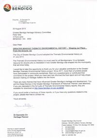
Thank you letter to Peter Ellis from Dr Danielle Orr, Heritage Planner from the City of Greater Bendigo for his contribution to the Greater Bendigo thematic Environmental History Project. Included is a copy of the Greater Bendigo 'Framwork of Historical Themes'. Listed on the brochure are the historical themes with some brief information on each. The other side has a photo of the former Mechanics Institute and School of Mines, Bendigo and reasons of What, How and Why it is significant.City Of Bendigo, Dr Dannielle Orr Heritage Planner.communication, postal, letters, peter ellis collection, city of greater bendigo, dannielle orr, greater bendigo heritage advisory committee, peter ellis, the thematic environmental history, anthony webster -
 Bendigo Historical Society Inc.
Document - GERMAN HERITAGE SOCIETY COLLECTION: MUSIC - THE MILLER'S WOOING
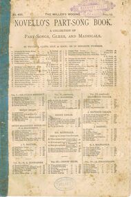
Novello's Part-Song Book containing the words and music for 'The Miller's Wooing'. The words by Julia Goddard and the music composed by Eaton Faning. It has music for Soprano, Alto, Tenor, Bass and Piano. More music is listed on the front and back covers with prices. St Paul's Harmony Club stamped in purple at the top of the front cover and at the bottom stamped in blue is Allan's Collins Street Melbourne.Novello Ewer and Co., 1 Berners Street (W) 80 & 81 Queens Street (E.C.) Londonperforming arts, music, singing, german heritage society collection - music - the miller's wooing, novello's part-song book, st paul's harmony club bendigo, allan's collins street melbourne, julia goddard, eaton faning -
 Bayside Gallery - Bayside City Council Art & Heritage Collection
Honour Board, Mayors of the Brighton Municipality
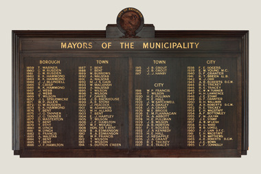
Dark wood honour board with gold lettering attached to the wall in the foyer at the Brighton Town Hall. A roundel in timber relief at the top containing the City of Brighton crest and British Coat of Arms. Below that is a raised timber relief panel inscribed in gold lettering 'MAYORS OF THE MUNICIPALITY'. The list of names and dates of the mayors from 1859 to 1965 is split over 2 raised timber panels, in four columns and divided by the headings BOROUGH, TOWN and CITY. mayor, municpality, brighton, city of brighton, borough of brighton, town of brighton, honour board, crest, coat of arms, brighton town hall -
 Bayside Gallery - Bayside City Council Art & Heritage Collection
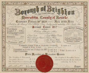
Certificate - Illuminated certificate, Brighton Municipal Certificate, 1872
bayside city council, borough of brighton, illuminated, certificate, population, rates, public buildings, wp allen, mayor, town clerk, surveyor, councillors, council, borough, county of bourke -
 Bayside Gallery - Bayside City Council Art & Heritage Collection
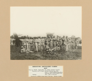
Photograph - gelatin silver photograph, Brighton Artillery Corps, 1865
Gelatin silver photograph of Officers of the Brighton Artillery Corps taken in 1865 on Parade Ground Drill Hall, Middle Crescent, Brighton. A cutout on the mount around a label with the soldiers' names listed. Standing, L to R: George Webb, Woodleigh, Rigg, Moule, Dixon, -, Selwyn, Walstab, Colonel William Mair (side on) Stamp, Gifford. Reclining, L to R: Were, Hallet, Strudwick. This photograph was donated by Mr William Herbert Edgar, grandson of Colonel William Mair.brighton artillery corps, soldier, colonel william mair, j. h. were, j. l. strudwick, drill hall, middle crescent, brighton, george wbb, woodleigh, rigg, moule, dixon, selwyn, g. walstab, stamp, giffod, hallet, strudwick, william herbert edgar -
 Bayside Gallery - Bayside City Council Art & Heritage Collection
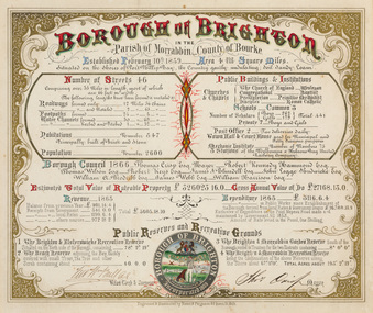
Certificate - Illuminated certificate, Hamel & Fergsuon, Brighton Municipal Certificate, 1866
bayside city council, borough of brighton, illuminated, certificate, population, rates, public buildings, mayor, town clerk, surveyor, councillors, council, borough, county of bourke, thomas crisp, cr t. crisp, census, parish of moorabbin, hamel & ferguson, coat of arms -
 Bendigo Historical Society Inc.
Document - MERLE HALL COLLECTION: ROSALIND PARK CREATIVE VILLAGE BENDIGO PROJECT AND FINAL REPORTS, 1995
MERLE HALL COLLECTION: ROSALIND PARK CREATIVE VILLAGE BENDIGO Project and Final Reports 3858.13 PDF File 11th August 1997 - three pages From: Merle Hall, Secretary Arts Bendigo To: Mike (final Media Release probably the Bendigo Advertiser) Content: Media Release two pages and a poem read out by Mosaic Artist Maery Gabriel (Hall) 'Reflections from Rosalind Park' Date Unknown: First invitation mail-out for C.V.T. Presentation and notes. Invitations to Felicity Kingerlee, Rod, Orr, Jane Cleary, Ian Stewart (Flora Hill Secondary College), Marion Stewart (White Hills Secondary College), Marion Wright, G. Maddams (& staff), Frank Ham, Tony Morris (Astronomy chap), Trevor Tonking (Cont. Ed.), Bernard smith and others at City of Bendigo, All A.B. Committee. Included are handwritten notes. Date Unknown: Two page document entitled: Enhancing the livable environment. Document contains details of the project, aims etc. 14th March 1995 To: The Greater City of Bendigo From Arts Bendigo Content: Two pages, a formal proposal for the involvement of the City of Greater Bendigo in the Creative Village project of the V.A.C. It contains information on Background, Concept,Implementation,Expected outcomes, Summary, Appendix 1 and 2 (Examples of the work of the artist). Date Unknown From John L. Content: one page of notes on similar projects and involvement by Arts Bendigo. The title of the document is Creative Village - Enhancing the Livable Environment. 5th Septemberh 1995 To: Members of the community who contributed ideas and suggestions From Arts Bendigo Ann Buzza and Merle Hall. Content: Invitation to attend a meeting with the Creative Village Team to view the Team's full report and explanation of designs etc. 9-10 June To: Participants in the Maery Hall Workshop From Arts Bendigo Ann Buzza and Merle Hall. Content: Location - ceramic department, Fine Arts building, Latrobe University Bendigo; acces information and what to bring to the workshop. Date Unknown To: City of Greater Bendigo Content: Arts Bendigo committment to the guidelines discussed with the relevent Council officers. Date Unknown To: City of Greater Bendigo From Arts Bendigo Content: Title - Historic Mining Mosaic Pavement at rosalind Park Poppet Head. A report on the project so far. Typed and ewritten notes. 28 July To: Public From Arts Bendigo Merle Hall. Content: Public invite to mark the completion of the project. June 1997 To: Public Content: A copy of Bendigo Heritage Mosaic City of Greater Bendigo plaque. 2nd September To: Attention Leanne McDonnell, Bendigo Advertiser From Arts Bendigo Merle Hall. Content: Media Release on 'The Laying Begins' Date Unknown To: Potential Donors From Arts Bendigo Merle Hall, sponsorship committee. Content: Description of the project titled 'Exciting Addition to Bendigo's Central Area. Date Unknown To: Potential Donors From Arts Bendigo Merle Hall, sponsorship committee. Content: Description of the project titled 'Exciting Addition to Bendigo's Central Area. Date Unknown List of LEAP team members for the project. Date Unknown To: Emma Power From Arts Bendigo Secretary Merle Hall. Content: three pages of information on the project (1. Intoduction 2. Small leaflet, prepared for visitors to the team 3. General outline of the project and the background on the Creative Village Team. 19-21 July To: All schools of the Bendigo area From: Merle Hall Secretary Arts Bendigo Content: An invitation for staff and students to visit the Creative Village Team during their time in Bendigo, at the Central Library on 19-21 July 19-21 July To: The Public From: Merle Hall Secretary Arts Bendigo Content: An invitation for staff and students to visit the Creative Village Team during their time in Bendigo, at the Central Library on 19-21 July 5th October 1995 To: Mr Peter Seamer, Chief Executive Officer, City of Greater Bendigo. From Merle Hall Secretary Arts Bendigo Content: RE 'Creative village team report and ongoing plans' 14 March 1996 To: Committee of Arts Bendigo From: Ann Buzza Content: Two pages hand-written report on visit of Maery Hall ot Bendigo 14/3/96 Date Unknown To: Bernard Smith, City ogf Greater Bendigo From: Merle Hall, Secretary Arts Bendigo Content: A list of urgent requirements needed by May 24th, material list from council stock. 27 June 1996 To: The Professionals, 54 Mitchell Street Bendigo, Attention Stephen Carter From: Merle Hall, Secretary Arts Bendigo Content: Account for use of shop in Allan's walk and cheque. 2nd July 1996 To: Cr Megan Weston Mayor, city of Greater Bendigo, copy to Bernard Smith. From: Merle Hall, Secretary Arts Bendigo Content: Thank you for $3500 to match the Arts Bendigo sponsorship. 2 June 1996 To: James C donnelly and associates, 5 School Lane, Wangi Wangi. From: Merle Hall, Secretary Arts Bendigo Content: Draft cover letter including a one page draft letter and a two page submission. James Donnelly was a parent of one of the LEAP workers who were helping on the project. James donnelly had suggestions for approaching mining companys for potential sponsorship. 1st October 1996 To: Mr D. Goldsworthy, City of Greater Bendigo From: Merle Hall, Secretary Arts Bendigo Content: Historic mining Mosaic Project, Rosalind Park Poppet Head. A formal submission for the council for some essential provisions for the extension of work on this project. 1st October 1996 To: Cr M. Weston, Mayor, City of Greater Bendigo. From: Merle Hall, secretary arts Bendigo Content: Three pages including a listing of income and costs to the project. 28th October 1996 To: Arts Bendigo From: Maery Hall Artist Content: two page report on the status of the project and problems that have been faced. 19th To: Leanne (maybe the Bendigo Advertiser) From: Merle Hall, secretary arts Bendigo Content: two pages on the finished project (Bendigo's Newest attraction) 19th March 1997 To: Steve From: Merle Hall, secretary arts Bendigo Content: Asking for rough quotes for printing of brochures. Date Unknown To: The Bendigo Bank From: Merle Hall, secretary arts Bendigo Content: two pages seeking a sum of $1000 to complete the project. 28th April 1997 To: Suzi Birthisel, Sponsorship Coordinator, Bendigo bank, Fountain Court, Bendigo From: Merle Hall, secretary arts Bendigo Content: Asking for a small sum for production of coloured brochures Date Unknown To: Committee From: Merle Hall, secretary arts Bendigo Content: Suggested invitation list from 'Arts Victoria' to the Committee re the opening on 28th July of the Bendigo Heritage Mosaic. 28 July 1997 From: City of Greater Bendigo and Arts Bendigo to public Content: Invitation to a brief ceremony to mark the occasion of the completion of The Bendigo Heritage Mosaic at the Poppet Head Lookout, Rosalind Park on Monday 28 July 1997. 5th August 1999 From: Merle Hall, Secretary Arts Bendigo To: Cr. B. Ackerman, Mayor, City of Greater Bendigo. Content: A brief note from the committee of Arts Bendigo, in appreciation of your attendance and speech at the 'completion ceremony, last week. 30th October 1997 From Merle Hall, Secretary Arts Bendigo To: the National Community links Awards, Category 1 - Arts and Culture Content: Included were Nomination Form, Written Statement as required under (5), a written reference from the mayor of the City of Greater Bendigo, two pages of photographs of the project, and five copies of a brochure printed to publicise the project. 2nd Feb 1998 From Merle Hall, Secretary Arts Bendigo To: Mrs. S. Parain, President, Regional Arts Fund Content: Regional Arts Fund Application, Sections 1 to 4 requesting a grant of $5197.00 -
 Bendigo Historical Society Inc.
Administrative record - GERMAN HERITAGE SOCIETY COLLECTION: DONATED ITEMS LIST, 2013
... GERMAN HERITAGE SOCIETY COLLECTION: DONATED ITEMS LIST ...Document listing items donated to the Bendigo Historical Society in September 2013. Three pages.bendigo, clubs, german heritage society, german heritage society collection -
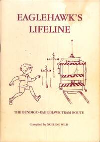 Ballarat Tramway Museum
Book, Noelene Wild, "Eaglehawk's Lifeline", 1997
Book, "Eaglehawk's Lifeline" details the history and operation of the Bendigo to Eaglehawk tram route. The tram service, operated by the SEC ceased in 1972. Has a table of contents, forward written by Dennis Bell and an introduction written by the author Noelene Wild. Published by the Eaglehawk Heritage Society 1997. Includes many photographs, and a (not fully inclusive) list of people who worked on the line in various capacities. Provides a detailed history of the Eaglehawk Bendigo tram route.Book - 72 A5 pages + card covers centre stapledtrams, tramways, eaglehawk, noelene wild, sec, bendigo -
 Kew Historical Society Inc
Plan - Subdivision Plan, H C Crouch, Old Golf Links Estate, 1930s
The land in North Kew between the Outer Circle Railway and the River Yarra was released in sections. This release included 80 lots. Most of this area was released during the Depression years in the early 1930s.Subdivision plans are historically important documents used as evidence of the growth of suburbs in Australia. They frequently provide information about when the land was sold on which a built structure was subsequently constructed as well as evidence relating to surveyors and real estate and financial agents. The numerous subdivision plans in the Kew Historical Society's collection represent working documents, ranging from the initial sketches made in planning a subdivision to printed plans on which auctioneers or agents listed the prices for which individual lots were sold. In a number of cases, the reverse of a subdivision plan in the collection includes a photograph of a house that was also for sale by the agent. These photographs provide significant heritage information relating house design and decoration, fencing and household gardens.One part of a massive subdivision of the Old Golf Links Estate in North Kew of 80 allotments bordering Sutherland Avenue, Ramsay Avenue, Belford Road, Beresford Street and Coleman Avenue. Inset on the plan at the top left, the route of the Outer Circle Railway is clearly marked. The Kew Golf Links is identified in its current location. The land on which Greenacres Golf Club was to be constructed is at this time marked as ‘Recreation Ground’. The ‘new bridge’ over the Yarra at Burke Road is also marked on the inset map. The Plan identifies the surveyor (sic) H.C. Crouch BCE MVIS, 443 Little Collins St., Melbourne. The date of the subdivision auction sale in identified as Saturday September 25th at three o'clock.Annotations: "E" top left. "Golf Links" top right. Lots 73-76 ticked and listed as "6" poundssubdivisions -- kew (vic.), old golf links estate -
 Kew Historical Society Inc
Photograph - Cosy Five Roomed Rough Cast Bungalow, Kew, J E Barnes, c.1920
Subdivision plans are historically important documents used as evidence of the growth of suburbs in Australia. They frequently provide information about when the land was sold on which a built structure was subsequently constructed as well as evidence relating to surveyors and real estate and financial agents. The numerous subdivision plans in the Kew Historical Society's collection represent working documents, ranging from the initial sketches made in planning a subdivision to printed plans on which auctioneers or agents listed the prices for which individual lots were sold. In a number of cases, the reverse of a subdivision plan in the collection includes a photograph of a house that was also for sale by the agent. These photographs provide significant heritage information relating house design and decoration, fencing and household gardens. The photograph is also aesthetically significant as it was taken by J. E. Barnes, a nationally significant photographer. He was the most important photographer to have worked in Kew. He was active as a photographer in the district from c.1906 until his death in 1921. Best known as 'the Embarkation Photographer' (see the Australian War Memorial collection), Josiah Earl Barnes was also the official photographer employed by the Borough (and later Town, then City) of Kew. He clearly also completed commercial jobs for local businesses, as is the case in this photograph of a house for a local real estate and financial agent. A modest weatherboard house with rough-cast rendered walls. The gabled entrance incorporates elements of the Japanese aesthetic. The strong lines of the dark timber gable are reinforced by the colour and shape of the pickets in the fence. In contrast to an earlier period, the chimneys appear truncated. The use of extensive double-hung sash windows in the front rooms reflects a new interest in light in houses. The use of separate sunshades over windows in an earlier period is here replaced by an extension of the roofline over the window. The photographer Josiah Barnes died in 1921; so, the photograph of the house must predate this date. The location of the house, which was advertised for sale, has to date not been identified. Illegible inscription. Photographer's information on mount.josiah earl barnes, j e barnes, photography - kew, interwar housing - victoria, 1920s housing - kew -
 Kew Historical Society Inc
Photograph - 2 Young Street, Kew, Paramount Photos, 1920s
Subdivision plans are historically important documents used as evidence of the growth of suburbs in Australia. They frequently provide information about when the land was sold on which a built structure was subsequently constructed as well as evidence relating to surveyors and real estate and financial agents. The numerous subdivision plans in the Kew Historical Society's collection represent working documents, ranging from the initial sketches made in planning a subdivision to printed plans on which auctioneers or agents listed the prices for which individual lots were sold. In a number of cases, the reverse of a subdivision plan in the collection includes a photograph of a house that was also for sale by the agent. These photographs provide significant heritage information relating house design and decoration, fencing and household gardens.A prepossessing, large home constructed in the Arts and Crafts style. Located on the banks of the Yarra at 2 Young Street, Kew overlooking the factories of Richmond, the design of the house takes account of the gradient with the addition of a level below the front entrance. The elegant roof includes a number of projecting gables and dormers. The gables are typically half-timbered and rendered. In addition to the asymmetrically placed portico, there are at least two open verandas, supported by timber pillars and with roofs that reflect the overall pitch of the roof of the housereal estate photographs, 2 young street - kew -
 Kew Historical Society Inc
Photograph - 29 Uvadale Grove, Kew, 1920
The numerous subdivision plans in the Kew Historical Society's collection represent working documents, ranging from the initial sketches made in planning a subdivision to printed plans on which auctioneers or agents listed the prices for which individual lots were sold. In a number of cases, the reverse of a subdivision plan in the collection includes a photograph of a house that was also for sale by the agent. Subdivision plans are historically important documents used as evidence of the growth of suburbs in Australia. They frequently provide information about when the land was sold on which a built structure was subsequently constructed as well as evidence relating to surveyors and real estate and financial agents. These photographs provide significant heritage information relating house design and decoration, fencing and household gardens.When 29 Uvadale Grove, Kew was offered for sale it was described as: ‘Kew. Fine locality, 3 minutes Cotham Road. Splendidly built 6 roomed Brick Villa. Rooms 17 x 14, 16 x 13, &c. Beautifully fitted throughout. Land 70 x 134 to ROW.’ The price was advertised as being £1,400. The house exhibits key features of Federation architecture such as the gabled roof with a facing of half-timber and stucco. The veranda has a curved corrugated iron roof supported by timber pillars and fretwork. The slate roof with terra cotta ridging and finials marks a transition to the more common use of Marseilles tiles in Federation architecture.subdivisions - kew (vic.), 29 uvadale grove - kew (vic.) -
 Kew Historical Society Inc
Photograph - 'Mount Eri', 9 Highbury Grove, 1919
Subdivision plans are historically important documents used as evidence of the growth of suburbs in Australia. They frequently provide information about when the land was sold on which a built structure was subsequently constructed as well as evidence relating to surveyors and real estate and financial agents. The numerous subdivision plans in the Kew Historical Society's collection represent working documents, ranging from the initial sketches made in planning a subdivision to printed plans on which auctioneers or agents listed the prices for which individual lots were sold. In a number of cases, the reverse of a subdivision plan in the collection includes a photograph of a house that was also for sale by the agent. These photographs provide significant heritage information relating house design and decoration, fencing and household gardens.A photograph of Mount Eri, 9 Highbury Grove, an 11-room house for sale near the junction of Cotham and Glenferrie Roads. The substantial red brick, slate-roofed house and its location are not identified in the photograph, although the extent of the house is noted. It was described then as ‘well situated’ and close to 3 trams. Mathers, a financial agent in Cotham Road, placed advertisements about the sale of the property in The Argus in May and June 1919. The advertisement additionally refers to a billiard room and asserts that the house has every modern convenience. An annotation on the plan indicates that the house, with tennis court, was sold for £1960. Following extensive research, the house has now been conclusively identified, albeit extended and rendered. The house was originally built in the 19th century as a school and for much of the 20th century was used as a venue for receptions. -
 Kew Historical Society Inc
Photograph - Victorian Villa, High Street, c.1922
Subdivision plans are historically important documents used as evidence of the growth of suburbs in Australia. They frequently provide information about when the land was sold on which a built structure was subsequently constructed as well as evidence relating to surveyors and real estate and financial agents. The numerous subdivision plans in the Kew Historical Society's collection represent working documents, ranging from the initial sketches made in planning a subdivision to printed plans on which auctioneers or agents listed the prices for which individual lots were sold. In a number of cases, the reverse of a subdivision plan in the collection includes a photograph of a house that was also for sale by the agent. These photographs provide significant heritage information relating house design and decoration, fencing and household gardens.An old inscription on this photograph identifies it as ‘an elegant timber villa in High Street. It occupied part of Lot 91, bought by Edward Glyn in the land sale of 16th October 1851, and run as a flower farm’. The subdivision called the ‘Flower Farm Estate’ in East Kew occurred in 1922. [The subdivision plan is on the reverse of this photo.] The Estate included 61 lots on either side of Boorool Road between High Street and Harp Road. In the MMBW Detail Plan 2017 of 1926, a number of these new villas had already been built. Matching houses with MMBW maps can always be a challenge, however if this house was near the corner of Boorool Road and High Street, it seems to fit the profile of a house called ‘Maxton’ (demolished).Photographer's name on photograph, lower right, and stamp on mount lower right: "A. Aberline, Glenferrie".houses - maxton - high street - kew (vic.), violet farm estate, subdivisions - kew (vic.) -
 Kew Historical Society Inc
Photograph - 8 roomed DF Brick Villa, Kew, J E Barnes, c.1920
Subdivision plans are historically important documents used as evidence of the growth of suburbs in Australia. They frequently provide information about when the land was sold on which a built structure was subsequently constructed as well as evidence relating to surveyors and real estate and financial agents. The numerous subdivision plans in the Kew Historical Society's collection represent working documents, ranging from the initial sketches made in planning a subdivision to printed plans on which auctioneers or agents listed the prices for which individual lots were sold. In a number of cases, the reverse of a subdivision plan in the collection includes a photograph of a house that was also for sale by the agent. These photographs provide significant heritage information relating house design and decoration, fencing and household gardens. The photograph is of additional aesthetic significance as it was photographed by J. E. Barnes. Josiah Earl Barnes is a nationally significant photographer. He was also the most important photographer to have worked in Kew. He was active as a photographer in the district from c.1906 until his death in 1921. Best known as 'the Embarkation Photographer' (see the Australian War Memorial collection), J. Earl Barnes was also the official photographer employed by the Borough (and later Town, then City) of Kew. He clearly also completed commercial jobs for local businesses, as is the case in this photograph of a house for a local real estate and financial agent.A photograph, mounted on board of a double fronted Federation-era brick villa in Kew, photographed for a local real estate agent and financier by J. E. Barnes of Kew. On the reverse of the photograph is a subdivision plan for the Normanby Estate, East Kew - 2016.0039.1. As can be seen from the image, there is a large tear on the surface of the photograph.The brown card on which the photograph is mounted includes the following handwritten description, which may aid the identification of the house: "Kew, 3 minutes from tram, 8 roomed DF Brick Villa, tile roof including two attics, sleepout, bathroom, heater, E Light, Entrance Hall, double doors, leadlights, laundry, garden, lawns, land 75 x 170, 1975 pounds". Also photographers inscription on mount, lower left: J. E. Barnes / Photo / Phone 1966 Haw. KEW.j. e. barnes, josiah earl barnes, j. earl banes - photographer, architecture - federation style, houses - kew, real estate photographs -
 Kew Historical Society Inc
Photograph - W.B. Villa, Kew, c.1919
The photograph offers significant information relating to late Victorian / Federation colour schemes and fencing.The block fronted villa has a corrugated iron roof and a flat projecting verandah, ornamented with a trellis design of timber. The front window features a timber shade, mounted on brackets. The treatment of the block-fronted panels shows that there is an attempt to highlight imitation quoining through use of a darker colour. The windows and door are also in this darker shade. The front fence and gate are made of wooden pickets. It is unlikely that the photograph was taken at the time of the villa's construction given the size of the shrub/tree in the front garden.Subdivision plans are historically important documents used as evidence of the growth of suburbs in Australia. They frequently provide information about when the land was sold on which a built structure was subsequently constructed as well as evidence relating to surveyors and real estate and financial agents. The numerous subdivision plans in the Kew Historical Society's collection represent working documents, ranging from the initial sketches made in planning a subdivision to printed plans on which auctioneers or agents listed the prices for which individual lots were sold. In a number of cases, the reverse of a subdivision plan in the collection includes a photograph of a house that was also for sale by the agent. These photographs provide significant heritage information relating house design and decoration, fencing and household gardens.A real estate photograph, mounted on brown card, showing a double fronted weatherboard villa, located in Kew, Victoria. On the reverse of the photograph is a subdivision plan for the Altyre Estate.Stamped on mount: Top - "KEW. Close tram. Fine View. / W.B. Villa Containing 8 Rooms. / Up-to-date Conveniences. EL Etc." Below - "Land 40 x 165. 615 pounds. Sold"houses - kew, real estate photographs -
 Kew Historical Society Inc
Photograph - Brick and Stucco Bungalow, J E Barnes, c.1920
The Kew Historical Society's map collection includes a substantial number of real estate subdivision plans, mainly of Kew but also of surrounding suburbs in Melbourne. Most of the subdivision plans date from the 1920s and 1930s when the districts old homes and local farmland were being split up to accommodate residential growth in the postwar period. These early plans were assembled by a local firm, Jas R Mather & McMillan, which had an office in Cotham Road. Many of the plans, and sometimes photos, were annotated by the agents.Subdivision plans are historically important documents used as evidence for the growth of suburbs in Australia. They frequently provide information about when the land was sold as well as evidence relating to surveyors and real estate and financial agents. The numerous subdivision plans in the Kew Historical Society's collection represent working documents, ranging from the initial sketches made in planning a subdivision to printed plans on which auctioneers or agents listed the prices for which individual lots were sold. In a number of cases, the reverse of a subdivision plan in the collection includes a photograph of a house that was also for sale by the agent. These photographs provide significant heritage information relating house design and decoration, fencing and household gardens.The photograph may also be aesthetically significant depending o the importance of the photographic atelier.Real estate photograph for a local agent by the Kew photographer, Josiah Earl Barnes. The photo is of a weatherboard or brick rendered bungalow with a twisted wire fence. Given Barnes' status a a Kew photographer, the house is probably locate din Kew or East Kew. Unfortunately the handwritten information on the mount bordering the photo is damaged and cannot be read. The bungalow has a gabled, tiled roof with terra cotta finials at the front of both gables. The house has a central doorway, framed by a pseudo portico supported by four wooden columns. On each side of the doorway, at the front, there are paired sash windows, which, like the half-timbered gable, are picked out in a darker colour.Handwritten, mostly illegible description by selling agent on mount surround: " .... in Diningroom, Drawing Rooms, ... Photographers details printed on mount: "J. E. Barnes / Photo / Phone 1966 Haw KEW"houses - kew, bungalows - kew, real estate photographs, j.e. barnes -- photographer -
 Kew Historical Society Inc
Photograph - Victorian Double-fronted Brock Villa, Cotham Road, c. 1919
The Kew Historical Society's map collection includes a substantial number of real estate subdivision plans, mainly of Kew but also of surrounding suburbs in Melbourne. Most of the subdivision plans date from the 1920s and 1930s when the districts old homes and local farmland were being split up to accommodate residential growth in the postwar period. These early plans were assembled by a local firm, Jas R Mather & McMillan, which had an office in Cotham Road. Many of the plans, and sometimes photos, were annotated by the agents.Subdivision plans are historically important documents used as evidence for the growth of suburbs in Australia. They frequently provide information about when the land was sold as well as evidence relating to surveyors and real estate and financial agents. The numerous subdivision plans in the Kew Historical Society's collection represent working documents, ranging from the initial sketches made in planning a subdivision to printed plans on which auctioneers or agents listed the prices for which individual lots were sold. In a number of cases, the reverse of a subdivision plan in the collection includes a photograph of a house that was also for sale by the agent. These photographs provide significant heritage information relating house design and decoration, fencing and household gardens.The photograph may also be aesthetically significant depending o the importance of the photographic atelier.Real estate photographs of a classic double-fronted late Victorian brick villa. It central location in Cotham Road, Kew enabled the selling agent to note its proximity to the tram. With seven rooms, all ‘modern conveniences’, and land of 66×167, the house was to be sold for £1100. The villa has a number of interesting features including a pattern within the slate roof as well as the use of polychrome brickwork under the eaves and on the façade. The intricacy of the cast iron lace is emphasised by the line of projecting wooden blocks above it. The picket gate is painted a different colour to the pickets of the fence. The house has a name (illegible) that is attached to the inset cast iron lace of the central projecting gable in the veranda. Stamped on mount: "Kew. Central. Close tram. / Comfortable Brick Villa. / Containing 7 rooms / Modern conveniences: / Land 66 x 167. Sold 1100 pounds:"houses - kew, victorian villas, real estate photographs, cotham road - kew -
 Kew Historical Society Inc
Photograph - Double-fronted Edwardian Villa, c.1918
The Kew Historical Society's map collection includes a substantial number of real estate subdivision plans, mainly of Kew but also of surrounding suburbs in Melbourne. Most of the subdivision plans date from the 1920s and 1930s when the districts old homes and local farmland were being split up to accommodate residential growth in the postwar period. These early plans were assembled by a local firm, Jas R Mather & McMillan, which had an office in Cotham Road. Many of the plans, and sometimes photos, were annotated by the agents.Subdivision plans are historically important documents used as evidence for the growth of suburbs in Australia. They frequently provide information about when the land was sold as well as evidence relating to surveyors and real estate and financial agents. The numerous subdivision plans in the Kew Historical Society's collection represent working documents, ranging from the initial sketches made in planning a subdivision to printed plans on which auctioneers or agents listed the prices for which individual lots were sold. In a number of cases, the reverse of a subdivision plan in the collection includes a photograph of a house that was also for sale by the agent. These photographs provide significant heritage information relating house design and decoration, fencing and household gardens.The photograph may also be aesthetically significant depending on the importance of the photographic atelier.On the reverse of a subdivision plan of the Palmyra Estate (Kew) is a photograph of a double-fronted Edwardian villa. The weatherboard and stucco house with high brick chimneys provides a clear indication of the style of curtains and gardens in houses of the period. Holland blinds with lace inserts are used in the left front window. They are combined with long lace curtains. The garden, with its curved pathway is bordered with garden beds that include marguerite daisies and roses. Reflecting a new interest in the Australian landscape, tree ferns and ground ferns are planted closer to the house.houses - kew, architecture - edwardian, real estate photographs -
 Kew Historical Society Inc
Plan - Subdivision : Cotham and Glenferrie Roads, J R Mathers & McMillan
The Kew Historical Society's map collection includes a substantial number of real estate subdivision plans, mainly of Kew but also of surrounding suburbs in Melbourne. Most of the subdivision plans date from the 1920s and 1930s when the districts old homes and local farmland were being split up to accommodate residential growth in the postwar period. These early plans were assembled by a local firm, Jas R Mather & McMillan, which had an office in Cotham Road. Many of the plans, and sometimes photos, were annotated by the agents.Subdivision plans are historically important documents used as evidence for the growth of suburbs in Australia. They frequently provide information about when the land was sold as well as evidence relating to surveyors and real estate and financial agents. The numerous subdivision plans in the Kew Historical Society's collection represent working documents, ranging from the initial sketches made in planning a subdivision to printed plans on which auctioneers or agents listed the prices for which individual lots were sold. In a number of cases, the reverse of a subdivision plan in the collection includes a photograph of a house that was also for sale by the agent. These photographs provide significant heritage information relating house design and decoration, fencing and household gardens.The photograph may also be aesthetically significant depending on the importance of the photographic atelier.An undated and untitled hand-drawn and coloured subdivision plan detailing the boundaries of a number of irregular allotments bordering Cotham Road, Glenferrie Road and Stirling Avenue (now Stirling Street). The plan predates the actual subdivision that led to the creation of the eight commercial properties occupying 118-132 Cotham Road. The plan may represent an old subdivision that was further subdivided at a later date, or it may be a subdivision that never eventuated. On MMBW Detail Plan 1575 (1903), the area represented by the proposed subdivision was residential rather than commercial. The irregularity of lots is also apparent in the MMBW Plan. The largest of the unnumbered blocks on the hand-drawn subdivision plan may relate to the boundaries of the nineteenth century mansion identified as ‘Kelso’ on the MMBW Plan.subdivision plans - kew, cotham road - kew,, glenferrie road - kew , stirling avenue street - kew -
 Kew Historical Society Inc
Photograph - Cottage, probably East Kew, A. Aberline, 1920s
The Kew Historical Society's map collection includes a substantial number of real estate subdivision plans, mainly of Kew but also of surrounding suburbs in Melbourne. Most of the subdivision plans date from the 1920s and 1930s when the districts old homes and local farmland were being split up to accommodate residential growth in the postwar period. These early plans were assembled by a local firm, Jas R Mather & McMillan, which had an office in Cotham Road. Many of the plans, and sometimes photos, were annotated by the agents.Subdivision plans are historically important documents used as evidence for the growth of suburbs in Australia. They frequently provide information about when the land was sold as well as evidence relating to surveyors and real estate and financial agents. The numerous subdivision plans in the Kew Historical Society's collection represent working documents, ranging from the initial sketches made in planning a subdivision to printed plans on which auctioneers or agents listed the prices for which individual lots were sold. In a number of cases, the reverse of a subdivision plan in the collection includes a photograph of a house that was also for sale by the agent. These photographs provide significant heritage information relating house design and decoration, fencing and household gardens.The photograph may also be aesthetically significant depending on the importance of the photographic atelier.An elevated, modest weatherboard house, photographed towards the end of the construction phase. The lower section of the weatherboards are exposed and stained. The upper section is rendered with rough-cast. The tiled roof has a single gable that extends over the centrally placed front porch. On the porch, the door and single sidelight are filled with coloured leadlight whereas the casement windows in the front rooms contain plain glass. The leadlight and the wrought iron of the verandah are the only decorative elements of the utilitarian design. The location of the house, which was advertised for sale, has not to date been identified. The real estate photograph is mounted on the reverse of a subdivision plan for the Harvest Home Estate, Kew East.Photographer's stamp, lower right on mount: "A. Aberline, Glenferrie"houses - kew, bungalows - kew, real estate photographs -
 Kew Historical Society Inc
Photograph - Bungalow, probably East Kew, 1920s
The Kew Historical Society's map collection includes a substantial number of real estate subdivision plans, mainly of Kew but also of surrounding suburbs in Melbourne. Most of the subdivision plans date from the 1920s and 1930s when the districts old homes and local farmland were being split up to accommodate residential growth in the postwar period. These early plans were assembled by a local firm, Jas R Mather & McMillan, which had an office in Cotham Road. Many of the plans, and sometimes photos, were annotated by the agents.Subdivision plans are historically important documents used as evidence for the growth of suburbs in Australia. They frequently provide information about when the land was sold as well as evidence relating to surveyors and real estate and financial agents. The numerous subdivision plans in the Kew Historical Society's collection represent working documents, ranging from the initial sketches made in planning a subdivision to printed plans on which auctioneers or agents listed the prices for which individual lots were sold. In a number of cases, the reverse of a subdivision plan in the collection includes a photograph of a house that was also for sale by the agent. These photographs provide significant heritage information relating house design and decoration, fencing and household gardens.The photograph may also be aesthetically significant depending on the importance of the photographic atelier.An unusual bungalow that does not conform to a particular architectural style but which contains eclectic elements of the style of varying periods. The most striking element of the design is the cantilevered veranda that is supported by heavy chains that are attached to the central gable. This deep gable extends across most of the façade, forming an extensive veranda. Parts of this are infilled with screens. Seven wooden posts, whose lower halves are encased in rendered brick pillars, support this gabled veranda. The roof would appear to be covered with corrugated iron. The location of the house, which was advertised for sale, has to date not been identified. The real estate photo is on the reverse of a plan for the Myrtle Hill Subdivision, Kew.bungalows - kew, architecture - 1920s, real estate photographs -
 Kew Historical Society Inc
Plan - Subdivision Plan, J R Mathers & McMillan, Myrtle Hill Estate, East Kew, circa 1949, c.1949
The Kew Historical Society's map collection includes a substantial number of real estate subdivision plans, mainly of Kew but also of surrounding suburbs in Melbourne. Most of the subdivision plans date from the 1920s and 1930s when the districts old homes and local farmland were being split up to accommodate residential growth in the postwar period. These early plans were assembled by a local firm, Jas R Mather & McMillan, which had an office in Cotham Road. Many of the plans, and sometimes photos, were annotated by the agents.Subdivision plans are historically important documents used as evidence for the growth of suburbs in Australia. They frequently provide information about when the land was sold as well as evidence relating to surveyors and real estate and financial agents. The numerous subdivision plans in the Kew Historical Society's collection represent working documents, ranging from the initial sketches made in planning a subdivision to printed plans on which auctioneers or agents listed the prices for which individual lots were sold. In a number of cases, the reverse of a subdivision plan in the collection includes a photograph of a house that was also for sale by the agent. These photographs provide significant heritage information relating house design and decoration, fencing and household gardens.The photograph may also be aesthetically significant depending on the importance of the photographic atelier.Myrtle Hill, at 14 Vista Avenue, Kew, is of local historical and architectural significance as a good example of a large and imposing single-storey Italianate house of the early 1870s surviving in Kew. Originally sited on a large allotment overlooking Normanby Road, the setting of the house has been dramatically altered through extensive subdivision and development. The subdivision plan of the ‘Myrtle Hill Estate’ indicates that in one such subdivision, 11 allotments were created fronting Bowyer Avenue, Myrtle Avenue, and Normanby Road. The outline and building profile of Myrtle Hill is shown on the west side of Bowyer Avenue.The full (typed) title of this subdivision plan is :"Plan of SUBDIVISION of part of CROWN PORTION 83. / at KEW / PARISH OF BOROONDARA. / COUNTY OF BOURKE". / "MYRTLE HILL ESTATE / EAST KEW" In addition to the Title and subtitle, the plan also lists the advantages of the subdivision. -
 Kew Historical Society Inc
Plan - Subdivision Plan, J R Mathers & McMillan, Normanby Estate, c.1913
The Kew Historical Society's map collection includes a substantial number of real estate subdivision plans, mainly of Kew but also of surrounding suburbs in Melbourne. Most of the subdivision plans date from the 1920s and 1930s when the districts old homes and local farmland were being split up to accommodate residential growth in the postwar period. These early plans were assembled by a local firm, Jas R Mather & McMillan, which had an office in Cotham Road. Many of the plans, and sometimes photos, were annotated by the agents.Subdivision plans are historically important documents used as evidence for the growth of suburbs in Australia. They frequently provide information about when the land was sold as well as evidence relating to surveyors and real estate and financial agents. The numerous subdivision plans in the Kew Historical Society's collection represent working documents, ranging from the initial sketches made in planning a subdivision to printed plans on which auctioneers or agents listed the prices for which individual lots were sold. In a number of cases, the reverse of a subdivision plan in the collection includes a photograph of a house that was also for sale by the agent. These photographs provide significant heritage information relating house design and decoration, fencing and household gardens.The photograph may also be aesthetically significant depending on the importance of the photographic atelier.The Normanby Estate, which was adjacent to Normanby Road, Kew East, included thirty-one lots for sale. Streets on the subdivision plan include Adeney Avenue, Park Hill Road, Normanby Road, Weir Street and Wharton Street. Cotham Road and its tramway are shown nearby. The plan is interesting as it shows Wharton Street, named after the architect and town planner George Wharton, who was the first chairman of the Municipality of Kew. The street was to later be renamed Cecil Street. Also shown are proposed ‘Municipal Gardens’ where Parkhill Drive is now located."D" in top left corner. Stamped auctioneers contact details: "Jas. R. Mathers & Son & McMillan / Auctioneer & Land Salesmen, / 271 Collins Street / Melbourne" and Jas. R. Mathers / Estate & Financial Agent / Cotham Road / Kew".weir street - kew, wharton street - kew, normanby road - kew, cotham road - kew, municipal gardens - kew, park hill parkhill road - kew, braemar - kew, subdivision plans - kew -
 Kew Historical Society Inc
Plan, J R Mathers & McMillan, Sackville, Thomas & Lytton Streets, Kew, Twentieth Century
The Kew Historical Society's map collection includes a substantial number of real estate subdivision plans, mainly of Kew but also of surrounding suburbs in Melbourne. Most of the subdivision plans date from the 1920s and 1930s when the districts old homes and local farmland were being split up to accommodate residential growth in the postwar period. These early plans were assembled by a local firm, Jas R Mather & McMillan, which had an office in Cotham Road. Many of the plans, and sometimes photos, were annotated by the agents.Subdivision plans are historically important documents used as evidence for the growth of suburbs in Australia. They frequently provide information about when the land was sold as well as evidence relating to surveyors and real estate and financial agents. The numerous subdivision plans in the Kew Historical Society's collection represent working documents, ranging from the initial sketches made in planning a subdivision to printed plans on which auctioneers or agents listed the prices for which individual lots were sold. In a number of cases, the reverse of a subdivision plan in the collection includes a photograph of a house that was also for sale by the agent. These photographs provide significant heritage information relating house design and decoration, fencing and household gardens.The photograph may also be aesthetically significant depending on the importance of the photographic atelier.Lithographed subdivision plan for an un-named estate with 28 allotments facing Lytton, Sackville and Thomas Streets in Kew. The land would have originally formed part of the Dumaresq Estate. subdivision plans - kew, lytton street, sackville street, thomas street - kew -
 Kew Historical Society Inc
Plan - Subdivision Plan, Jas R Mathers Son & McMillan, Eastlawn Estate : East Kew Auction Sale, 1914
The Kew Historical Society's map collection includes a substantial number of real estate subdivision plans, mainly of Kew but also of surrounding suburbs in Melbourne. Most of the subdivision plans date from the 1920s and 1930s when the districts old homes and local farmland were being split up to accommodate residential growth in the postwar period. These early plans were assembled by a local firm, Jas R Mather & McMillan, which had an office in Cotham Road. Many of the plans, and sometimes photos, were annotated by the agents.Subdivision plans are historically important documents used as evidence for the growth of suburbs in Australia. They frequently provide information about when the land was sold as well as evidence relating to surveyors and real estate and financial agents. The numerous subdivision plans in the Kew Historical Society's collection represent working documents, ranging from the initial sketches made in planning a subdivision to printed plans on which auctioneers or agents listed the prices for which individual lots were sold. In a number of cases, the reverse of a subdivision plan in the collection includes a photograph of a house that was also for sale by the agent. These photographs provide significant heritage information relating house design and decoration, fencing and household gardens.The photograph may also be aesthetically significant depending on the importance of the photographic atelier.The ‘Eastlawn Estate’ was surveyed and ready for auction in March 1914, three months before the outbreak of World War I. Sixty-six allotments, created on the ‘order of Mr & Miss Preston’ surrounded the mansion of Woodlands in Harp Road. Woodlands formed part of the Estate, being advertised as lot 1. The allotments faced High, Station and Wright Streets, Harp and Normanby Roads, and Woodlands Avenue. Pru Sanderson in the Kew Conservation Study (Vol.2, 1988) wrote that the Eastlawn Estate ‘covered the western half of the failed Harp of Erin Estate’. Contemporary advertisements promoted the Eastlawn Estate as: ‘There will be no more convenient district nor pleasant Suburb than East Kew for the busy business man. When the Electric Tram is laid, he will be able to journey quickly and pleasantly direct from Collins Street to his home in the Eastlawn Estate in about 20 minutes’. The actual plans of subdivision were included in advertisements in The Argus and in the local newspapers."C" top left. Various annotations.subdivision plans - kew, station street, normanby road, high street, woodlands avenue, harp road, woodlands - kew -
 Kew Historical Society Inc
Plan - Subdivision Plan, Winton Estate, East Kew : Sale of 10 Building Blocks, 1920
The Kew Historical Society's map collection includes a substantial number of real estate subdivision plans, mainly of Kew but also of surrounding suburbs in Melbourne. Most of the subdivision plans date from the 1920s and 1930s when the districts old homes and local farmland were being split up to accommodate residential growth in the postwar period. These early plans were assembled by a local firm, Jas R Mather & McMillan, which had an office in Cotham Road. Many of the plans, and sometimes photos, were annotated by the agents.Subdivision plans are historically important documents used as evidence for the growth of suburbs in Australia. They frequently provide information about when the land was sold as well as evidence relating to surveyors and real estate and financial agents. The numerous subdivision plans in the Kew Historical Society's collection represent working documents, ranging from the initial sketches made in planning a subdivision to printed plans on which auctioneers or agents listed the prices for which individual lots were sold. In a number of cases, the reverse of a subdivision plan in the collection includes a photograph of a house that was also for sale by the agent. These photographs provide significant heritage information relating house design and decoration, fencing and household gardens.The photograph may also be aesthetically significant depending on the importance of the photographic atelier.Subdivision plan for the so-called Winton Estate in East Kew. The Estate comprised 10 lots facing Simpson Street and Campbell Street. The estate was auctioned by Jas. R. Mathers, Son and McMillan. campbell street, simpson street, hunter street, normanby road - kew, subdivision plans - east kew, subdivision plans - kew