Showing 1120 items
matching lower plenty, main road
-
 Eltham District Historical Society Inc
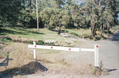
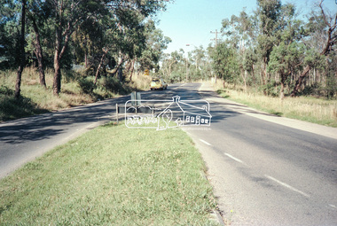
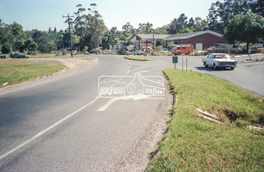
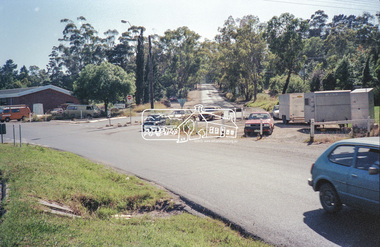
Negative - Photograph, Intersection of Mt Pleasant Road at Main Road, Eltham, c.Dec. 1983
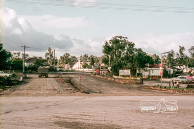
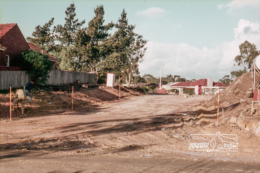
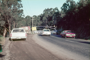
Reconstruction work was planned for Main Road to install a roundabout at Mount Pleasant Road. Traffic to Lower Plenty and Templestowe to be diverted down Bridge Street (and Bolton Street) effective January 1984. The proposed roundabout did not proceed. Instead traffic islands on Mount Pleasant Road were installed in place of temporary blocked out islands and revised extended driveway to properties 622-642 Main Road with access off Mount Pleasant Road instead.Film - Kodak CM 400 5079 7 strips, 26 framesinfrastructure, roads, road construction, roundabout, road sign, main road, mount pleasant road, eltham -
 Eltham District Historical Society Inc
Negative - Photograph, Intersection of Mt Pleasant Road at Main Road, Eltham, c.Dec. 1983
Reconstruction work was planned for Main Road to install a roundabout at Mount Pleasant Road. Traffic to Lower Plenty and Templestowe to be diverted down Bridge Street (and Bolton Street) effective January 1984. The proposed roundabout did not proceed. Instead traffic islands on Mount Pleasant Road were installed in place of temporary blocked out islands and revised extended driveway to properties 622-642 Main Road with access off Mount Pleasant Road instead.Film - Kodak CM 400 5079 7 strips, 26 framesinfrastructure, roads, road construction, roundabout, road sign, main road, mount pleasant road, eltham, service station -
 Eltham District Historical Society Inc
Negative - Photograph, Intersection of Mt Pleasant Road at Main Road, Eltham, c.Dec. 1983
Reconstruction work was planned for Main Road to install a roundabout at Mount Pleasant Road. Traffic to Lower Plenty and Templestowe to be diverted down Bridge Street (and Bolton Street) effective January 1984. The proposed roundabout did not proceed. Instead traffic islands on Mount Pleasant Road were installed in place of temporary blocked out islands and revised extended driveway to properties 622-642 Main Road with access off Mount Pleasant Road instead.Film - Kodak CM 400 5079 7 strips, 26 framesinfrastructure, roads, road construction, roundabout, road sign, main road, mount pleasant road, eltham -
 Eltham District Historical Society Inc
Negative - Photograph, Intersection of Mt Pleasant Road at Main Road, Eltham, c.Dec. 1983
Reconstruction work was planned for Main Road to install a roundabout at Mount Pleasant Road. Traffic to Lower Plenty and Templestowe to be diverted down Bridge Street (and Bolton Street) effective January 1984. The proposed roundabout did not proceed. Instead traffic islands on Mount Pleasant Road were installed in place of temporary blocked out islands and revised extended driveway to properties 622-642 Main Road with access off Mount Pleasant Road instead.Film - Kodak CM 400 5079 7 strips, 26 framesinfrastructure, roads, road construction, roundabout, road sign, main road, mount pleasant road, eltham -
 Eltham District Historical Society Inc
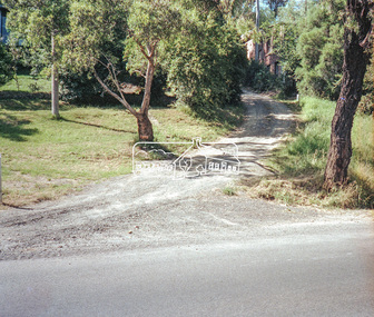
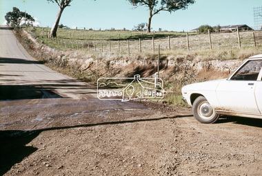
Slide - Photograph, Unidentified location, Eltham district, c.Aug. 1990
Part of a presentation, "Roads and Byways of the Shire of Eltham", by Russell Yeoman to the 12 September 1990 Society meeting. Slides shown included copies of old photos and recent images ranging from the suburban streets of Eltham and Montmorency to the mountain roads of Kinglake. In the byways category are views of some iof the Shire's bicycle paths including then recently completed sections of the Main Yarra Trail at Lower Plenty.35mm colour positive transparency (1 of 37) Mount - Agfachrome Agfa CS System black 8 dotseltham, infrastructure, roads, unidentified -
 Eltham District Historical Society Inc
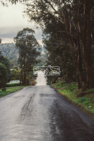
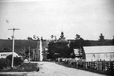
Slide - Photograph, Near the old Lower Plenty Bridge (present day Edward Willis Court), c.Aug. 1990
Part of a presentation, "Roads and Byways of the Shire of Eltham", by Russell Yeoman to the 12 September 1990 Society meeting. Slides shown included copies of old photos and recent images ranging from the suburban streets of Eltham and Montmorency to the mountain roads of Kinglake. In the byways category are views of some iof the Shire's bicycle paths including then recently completed sections of the Main Yarra Trail at Lower Plenty.35mm colour positive transparency (1 of 37) Mount - Agfachrome Agfa CS System black 8 dotsinfrastructure, roads, edward willis court, lower plenty, lower plenty bridge -
 Eltham District Historical Society Inc
Slide - Photograph, Main Road, Eltham, c.1910, c.Aug. 1990
... then recently completed sections of the Main Yarra Trail at Lower Plenty ...Part of a presentation, "Roads and Byways of the Shire of Eltham", by Russell Yeoman to the 12 September 1990 Society meeting. Slides shown included copies of old photos and recent images ranging from the suburban streets of Eltham and Montmorency to the mountain roads of Kinglake. In the byways category are views of some iof the Shire's bicycle paths including then recently completed sections of the Main Yarra Trail at Lower Plenty.35mm colour positive transparency (1 of 37) Mount - Agfachrome Agfa CS System black 8 dotsinfrastructure, roads, main road, eltham -
 Eltham District Historical Society Inc
Slide - Photograph, Eltham-Yarra Glen Road, Kangaroo Ground c.1910, c.Aug. 1990
Part of a presentation, "Roads and Byways of the Shire of Eltham", by Russell Yeoman to the 12 September 1990 Society meeting. Slides shown included copies of old photos and recent images ranging from the suburban streets of Eltham and Montmorency to the mountain roads of Kinglake. In the byways category are views of some iof the Shire's bicycle paths including then recently completed sections of the Main Yarra Trail at Lower Plenty.35mm colour positive transparency (1 of 37) Mount - Agfachrome Agfa CS System black 8 dotsinfrastructure, roads, eltham-yarra glen road, kangaroo ground -
 Eltham District Historical Society Inc
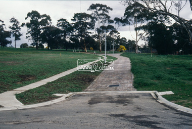
Slide - Photograph, Unidentified location, Eltham district, c.Aug. 1990
Part of a presentation, "Roads and Byways of the Shire of Eltham", by Russell Yeoman to the 12 September 1990 Society meeting. Slides shown included copies of old photos and recent images ranging from the suburban streets of Eltham and Montmorency to the mountain roads of Kinglake. In the byways category are views of some iof the Shire's bicycle paths including then recently completed sections of the Main Yarra Trail at Lower Plenty.35mm colour positive transparency (1 of 37) Mount - Agfachrome Agfa CS System black 8 dotsinfrastructure, roads, houses, private street scheme, residential, unidentified -
 Eltham District Historical Society Inc
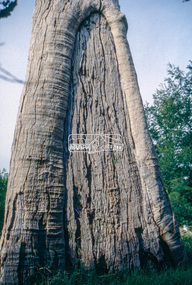
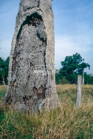
Slide - Photograph, Scar tree, Lower Plenty, c.Apr. 1993
Possibly near Bonds Road Lower Plenty35mm colour positive transparency (1 of 22) Mount - Kodak EktachromeProcess Date "Apr M"significant tree, lower plenty, scar tree -
 Eltham District Historical Society Inc
Slide - Photograph, Scar tree, Lower Plenty, c.Apr. 1993
Possibly near Bonds Road Lower Plenty35mm colour positive transparency (1 of 22) Mount - Kodak EktachromeProcess Date "Apr M"significant tree, lower plenty, scar tree -
 Eltham District Historical Society Inc
Slide, Reconstruction of Grand Boulevard viewed from Panorama Avenue, Montmorency, 18 August 1970, 1970
... as duplicate Main Road, Lower Plenty, east of Grand Boulevard including... station as well as duplicate Main Road, Lower Plenty, east ...The Eltham Apex Club conducted a Community Service Project (1965-1968) to raise funds for a new Ambulance Station to service the community. A site bounded by the intersection of Main Road, Grand Boulevard and Looker Road at Montmorency was purchased in 1969. In 1970, Eltham Shire Council undertook roadworks to construct Apex Way in preparation for the new station as well as duplicate Main Road, Lower Plenty, east of Grand Boulevard including the new Lower Plenty Bridge, which had been opened in November 1966, bordering with the City of Heidelberg.35 mm colour positive transparency Mount - Agfacolor Service (Blue)1970-08-18, apex-diamond valley ambulance station, eltham ambulance station, eltham apex club, grand boulevard, montmorency -
 Eltham District Historical Society Inc
Slide, Construction of Apex Way between Looker Road and Grand Boulevard, Montmorency, 18 August 1970, 1970
... as duplicate Main Road, Lower Plenty, east of Grand Boulevard including... in preparation for the new station as well as duplicate Main Road, Lower ...The Eltham Apex Club conducted a Community Service Project (1965-1968) to raise funds for a new Ambulance Station to service the community. A site bounded by the intersection of Main Road, Grand Boulevard and Looker Road at Montmorency was purchased in 1969. In 1970, Eltham Shire Council undertook roadworks to construct Apex Way in preparation for the new station as well as duplicate Main Road, Lower Plenty, east of Grand Boulevard including the new Lower Plenty Bridge, which had been opened in November 1966, bordering with the City of Heidelberg.35 mm colour positive transparency Mount - Agfacolor Service (Blue)1970-08-18, apex-diamond valley ambulance station, eltham ambulance station, eltham apex club, grand boulevard, looker road, montmorency -
 Eltham District Historical Society Inc
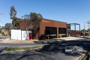
Photograph, Liz Pidgeon, Eltham Ambulance Station, Metropolitan Ambulance Service, Apex Way, Montmorency, just prior to demolition, 7 November 2017, 7 Nov 2017
... as duplicate Main Road, Lower Plenty, east of Grand Boulevard including... station as well as duplicate Main Road, Lower Plenty, east ...The Eltham Apex Club conducted a Community Service Project (1965-1968) to raise funds for a new Ambulance Station to service the community. A site bounded by the intersection of Main Road, Grand Boulevard and Looker Road at Montmorency was purchased in 1969. In 1970, Eltham Shire Council undertook roadworks to construct Apex Way in preparation for the new station as well as duplicate Main Road, Lower Plenty, east of Grand Boulevard including the new Lower Plenty Bridge, which had been opened in November 1966, bordering with the City of Heidelberg. The Eltham Ambulance Station was opened 4 May 1975 by the Hon. Roy M. Vale, M.L.A. It was demolished in November 2017 to make way for a new larger station which also houses a MICA unit, opened 29 August 2018 by the Hon. Jill Hennessey, Minister for State Ambulance Services.20 born digital imagesambulance station, apex way, eltham ambulance station, eltham apex club, montmorency -
 Eltham District Historical Society Inc
Photograph, Peter Pidgeon, Official opening of the new Eltham Ambulance Branch, Apex Way, Montmorency, 29 August 2018, 29 Aug 2018
... station as well as duplicate Main Road, Lower Plenty, east... station as well as duplicate Main Road, Lower Plenty, east ...Dignitaries included Ambulance Victoria CEO Tony Walker, Vicki Ward MP for Eltham and Jill Hennessey State Ambulance Services Minister The Eltham Apex Club conducted a Community Service Project (1965-1968) to raise funds for a new Ambulance Station to service the community. A site bounded by the intersection of Main Road, Grand Boulevard and Looker Road at Montmorency was purchased in 1969. In 1970, Eltham Shire Council undertook roadworks to construct Apex Way in preparation for the new station as well as duplicate Main Road, Lower Plenty, east of Grand Boulevard including the new Lower Plenty Bridge, which had been opened in November 1966, bordering with the City of Heidelberg. Diamond Valley Leader, September 5, 2018, p4. MONTMORENCY $1.6mil station unveiled A REVAMPED Montmorency ambulance station has been unveiled. State Ambulance Services Minister Jill Hennessy and Eltham State Labor MP Vicki Ward revealed the $1.6 million complex at the corner of Grand Boulevard and Apex Way in Montmorency. It replaces the 50-year-old station and now includes four ambulance bays, four rest and recline rooms, a large training room and offstreet parking for staff. “The community campaigned long and hard for this new ambulance station and I’m delighted to have stood with them all the way,” Ms Ward said. The latest quarterly performance data showed 90.4 per cent of ambulances in Banyule arrived within 15 minutes of Code 1 emergencies — up from 89.2 per cent three months earlier. Ms Hennessy said paramedics had worked in “cramped” facilities. “We’ve fixed that,” she said.55 born digital imagesambulance victoria ceo, apex way, apex-diamond valley ambulance station, eltham ambulance station, eltham apex club, jill hennessey, montmorency, mp for eltham, state ambulance services minister, tony walker, vicki ward -
 Eltham District Historical Society Inc
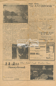
Newspaper clipping, Romantic, charming . . . ''SUNNYBROOK', Diamond Valley Local, 31 March, 1954, p4, 1954
Romantic, charming . . . ''SUNNYBROOK'' ON the slope of a hill on the East side of Bolton street and overlooking willows that trail gracefully in a creeklet which shows no great haste to blend with Diamond Creek and so to the Yarra, there stands a great old-fashioned home. Outwardly it speaks of past opulence rather than beauty of design, but the velvet green lawns and the formal neatly weeded rose gardens, the well established trees, tennis courts, wisteria covered pergolas and the great curved fronds of old palms produce an atmosphere that cannot be built-up in less than decades. Here is irresistible old-world charm. The jangle of today cannot penetrate ... it is a place to remember ... a place where events to be remembered have a perfect setting ... it is "Sunnybrook." From the neighbouring ‘Beranto Lodge’ Mrs. Lenne can catch glimpses of ‘Sunnybrook,’ but the old home is well hidden from all quarters and only the faultlessly kept lawn can be seen by the curious. Like many other people, Mrs. Lenne was curious. Who can blame her. ‘Sunnybrook’ is a name to conjure with in Eltham. When the elderly men of the township were young bucks ‘Sunnybrook’ stood alone, a proud home that was known and established. Amongst the simple homes of the valley of the Diamond Creek, ‘Sunnybrook’ was Queen. In the roistering days of the Diamond Valley, when Kangaroo Ground was the seat of the Shire and when five pubs dotted the road from Lower Plenty to the civic centre, ‘Sunnybrook’ was off the track of the boisterous and tipsy. ‘Sunnybrook’ is still off the beaten track . . . but only slightly so; it no longer looks over cow pastures, but the neat, newly built houses which dot the length of the Main Road. They are still no closer than half a mile and while these houses have sprung up the fine trees and shrubs have quietly closed in around the boundaries of ‘Sunnybrook' as if to keep the old place to itself. That is how it has become something to whet the curiosity. When the course of events put the place on the market Mrs. Lenne bought it. When a modern house is bought it is pliable in the sense that the owner moulds it according to personality. It can remain severe, utilitarian and with a little neglect soon run to an ugly shabbiness. But with old 'Sunnybrook' it is different. There is in existence a character indelibly written into every line of the place . . . it is a LOVE OF ENGLAND. Upon ‘Sunnybrook’ has been lavished the devoted love of England to such a degree that it must be seen. The gardens and lawns are formal, and though lovely and speaking of the leisure of past years they are not English . . . they are just lovely, with the beauty that only the long established seem to possess. It is inside ‘Sunnybrook’ that the intense love of England is seen. Years ago the home was bought by a Mr. Martin, who was getting on in years, as a home for his much younger wife. The couple spent thousands of pounds as well as endless care and imagination in the complete redecorating of their home. Oak panelling imported from England was built in. Huge fireplaces shed their Colonial appearance to be become the fireplaces of England . . . and they were so in every sense because they were also imported from England. One lovely specimen whose gracious lines are remarked upon by all who see it, is a certified antique of finest English Oak. Care was taken to see what hand made wrought iron light fittings were in keeping. The old place has three lounge, dining or living rooms according to taste and requirements, and all are bigger than the biggest attempted in a “big” modern home. This does not include an outside living space of ample proportions, all fine flywired in and enclosing a fernery. A turn of a tap and spray as fine as mist is released over the rockery. On a scorching summer day when no relief short of a swim could help ordinary people, the resident of ‘Sunnybrook’ found the coolness of a dell in which to sit and enjoy their evening meal. What is more, the temperature of the whole house could be reduced by merely turning on this extensive spray water system. Yes, comfort to luxury standard is built in. And what happens to 'Sunnybrook' now? Mrs Lenne is famous to thousands for her quite fabulous catering. Her home and her "Wanda Inn" at Hepburn Springs have long been a Mecca for those who want the different in catering . . . different in the sense that every client is treated as a friend, not a customer and the hospitality and attention one would give to an honoured friend is accorded. And the food! – ask anyone who has enjoyed the privilege. Ask those who attended the reception given to Mr. Menzies by Eltham Shire Council; ask those members of the Diamond Valley Chamber of Commerce who enjoyed it! [See EDHS_04736-1/2 https://victoriancollections.net.au/items/5d4c2fb521ea6727d892df72] There is only one word anyone ever uses . . . “unbelievable!” it must be seen and eaten to be believed. And ‘Sunnybrook’ will ring to the laughter, and offer its spaciousness for the fun of all who join in the happiest occasion in the life of those just married, whose wedding reception is intended to be “remembered.” Mrs. Lenne is a dynamic ball of energy whose enthusiasm is not to be brooked. She has acquired the home of her dreams. 13 March 2020 Note: Historian Stella M. Barber via the GSV members Forum cites that Clair Samwell and Doris Good ran a nursing home in Balwyn called Penquite (1946-1952). Prior to that the women had run a rest home called Beranto in Eltham. Single newsprint page separated rest of paperberanto lodge, bolton street, houses, mrs. lenne, prime minister, properties, robert gordon menzies, sunnybrook -
 Eltham District Historical Society Inc
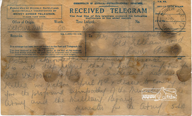
Telegram, Victoria Barracks, Melbourne to Mrs Annie Castledine, Old Eltham Road, Lower Plenty, 3 May 1941
"Postal acknowledgement delivery personal" "It is with deep regret that I have to inform you that VX10044 Sapper G. E. Castledine has been killed in action April 18th & desire to convey to you the profound sympathy of the Minister for the Army and the Military Board. - Minister for the Army" Sapper George Ernest Castledine (1914-1941), son of Arthur Frederick and Annie Castledine, enlisted 23 January 1940 at Lower Plenty and was assigned to the 2/2 Field Company. He is buried in the Phaleron War Cemetery, Athens, Greece and is remembered on the Roll of Honour at Eltham.George was the first soldier from the Shire of Eltham to be killed in the Second World War. The telegram is oil stained as it was kept by George's brother Sid in his toolbox.Digital image of original held in private collection of Joan Castledine (niece of George Ernest Castledine and daughter of Sid and Polly (nee Arrowsmith) Castledine).Original bears oil stains from being stored in a tool box2/2 field company, aif, annie castledine, arthur frederick castledine, eltham war memorial, george ernest castledine, military, minister for the army, roll of honour, second word war, sid castledine, telegram -
 Eltham District Historical Society Inc
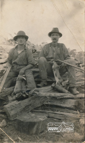
Photograph, Arthur Frederick Castledine (right) sitting on a wood pile towards the rear of their property, Araluen (southern end), Old Eltham Road, Lower Plenty, c.1930, 1930c
Shows the men with rifles sitting on a wood pile out hunting for rabbits around the time of the Great DepressionDigital image of original held in private collection of Joan Castledine, daughter of Sid and Polly (nee Arrowsmith) Castledine, granddaughter of Arthur Frederick Castledine.araluen, arthur frederick castledine, lower plenty, old eltham road, rabbits -
 Eltham District Historical Society Inc
Register, Register of Significant Trees, Shire of Eltham, 1993, 1993c
In 1983, the National Trust advised the Shire of Eltham that it was investigating a number of trees within the shire which had been nominated for recording the Register of Significant Trees of Victoria. The trees involved were described in the Shire of Eltham Historical Society Newsletter No. 29, March 1983 as follows:- 1. Eucalyptus melliadora (Yellow box) . a) An outstanding mature specimen 42 metres high in Laughing Waters Road, Eltham. b) Another mature specimen in Arthurs Creek road, Hurstbridge is reported to be the tree under which the bushranger Robert Bourke was tied after he shot and killed Henry Hurst in 1866 . 2. Quercus robur (English Oak). a) "Donaldson's Oak", Donaldsons Road, Kangaroo Ground was planted by John Donaldson from seed collected from Windsor Great Park in 1878. b) "Wippells Oak". This now misshapen tree is located on the St. Andrews Road near the Kangaroo Ground Fire Station. Its origins may have been similar to Donaldson's Oak, and as a young tree it apparently slipped from higher up the hill during wet weather. Both oaks are of local historical importance. 3. Eucalyptus globulus (Blue Gum). A large mature specimen at the corner of the Kangaroo Ground-St. Andrews Road and Bakehouse Road, Panton Hill. 4. Plantanas acerifolia (Plane tree) A number of trees forming the Avenue of Honour to Eltham's First World War soldiers along Main Road between Dalton and Pitt Streets, Eltham. 5. Pinus canariensis (Canary Island Pine), Pinus pinea, (Stone pine) and Cedras altlantica, (Cedar) These trees are located at the Hurst family graves in the grounds of the Hurstbridge Pre-school Centre. In 1991 the Shire of Eltham introduced controls into its planning scheme to protect sites of architectural, historic or conservation interest and significant trees. The controls were approved by the Minister for Planning and Housing. As advised in the Shire of Eltham Historical Society Newsletter No. 78, May 1991, a planning permit is required to demolish or alter any listed building or to destroy, lop or remove any listed tree. Provision is made for comments to be obtained from the National Trust or Historic Buildings Council in considering any applications. The buildings and trees listed were: Buildings: 250 Bolton Street Eltham (former Walter Withers home) "Rosehill" - Bonds Road Lower Plenty St Andrews Church of England - St Andrews "Montsalvat" - Hillcrest Avenue Eltham St Margarets Church and former vicarage - Pitt Street Eltham Presbyterian Church - Kangaroo Ground Parks and Environment Office (former police quarters) Main Road Eltham Former Court House - Main Road Eltham "Shillinglaw Cottage" - Main Road Eltham "The Robins" - Kangaroo Ground Road Warrandyte Trees: "Donaldsons Oak" - Donaldsons Road Kangaroo Ground Yellow Box - Laughing Waters Road Eltham Yellow Box - Arthurs Creek Road Hurstbridge Wippells Oak - St Andrews Road Kanqaroo Road Pines and Cedar - Hurst family cemetery Greysharps Road Hurstbridge Yellow Box - Parsons Road Eltham A large Blue Gum at Panton Hill has been listed but has recently died (1991). In 1993 work by Council Parks and Environment staff and volunteers resulted in the preparation of a Significant Tree Register listing forty-one trees or groups of trees. According to Shire of Eltham Historical Society Newsletter No. 91, March 1993, a similar number remained to be assessed for inclusion in the register. There is a wide range of indigenous and planted trees on private and public land and extending through the Shire of Eltham from Lower Plenty to Kinglake. Most can be viewed from publicly accessible locations. The Significant Tree Register lists 41 trees or groups of trees throughout the Shire. It contains a wide range of naturally occurring and planted trees. They have been assessed according to eleven criteria including size, age, rarity, historical value and the like. The list includes large old Red Gums at Lower Plenty, historic Oaks at Kangaroo Ground and Mountain Ash at Kinglake. The register includes a set of slides showing each tree. Garry Bartlett of the Council's Parks and Environment Section and Faye Shepherd were extensively involved in establishment of the register (Newsletter No. 93, November 1993). In 1999 Niliumbik planners prepared an amendment to the Planning Scheme to provide protection for approximately 200 of the places listed in the heritage studies and also in the Significant Tree Register commenced by the Eltham Council (Eltham District Historical Society Newsletter No. 127, July 1999. In 2004, The Register of Significant Trees was presented to the Eltham District Historical Society by Nillumbik Shire Council as part of a wider collection of of its memorabilia of the former Eltham Shire Council (EDHS Newsletter No. 159, July 2004. Album of loose handmade paper sheets contained within a handmade slip cover constructed of handcrafted card with encapsulated flora material (flowers, vines, ferns) and tinted. Each page also contains an embedded/adhered fern leaf also tinted with lacqueur or similar, text as appropriate in ink by hand calligraphy. Each page also has a white protective sheet cut to size and adhered to back surface with sticky tape and folded over face of page. Pages variously have photographs and coloured masks adhered with a gum resin. Over time much of this resin has let go and photos/masks have been reattached using acid free archival safe adhesive. 15 pages 41 x 29 cm inclusive of 3 blank pages. Slip case 42 x 30 x 1 cm; face cover of slip case has broken off at left hand margin as insufficient depth/flexibility for contents.arthurs creek road, blue gum (eucalyptus globulus), canary island pine (pinus canariensis), couties road, donaldsons oak, donaldsons road, eltham, english oak (quercus robur), eucalyptus melliodora, graysharps road, hurst tree, hurstbridge, ironbark (eucalyptus tricarpa), ironbark hill, kangaroo ground, kangaroo ground-kinglake road, laughing waters road, panton hill hotel, panton hill, parsons road, significant trees register, sonia van bodegraven, sonjart, stone pine (pinus pinea). atlantic cedar (cedrus atlantica), wippells oak, yellow box gum (eucalyptus melliodora), yellow box gum -
 Eltham District Historical Society Inc
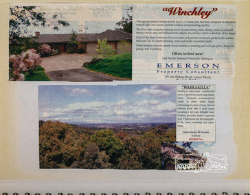
Newsclipping, Winchley, 179 Old Eltham Road, Lower Plenty and Warrakilla
Contained in Volume 1 of a set of two spiral magnetic photo albums, each containing 10 leaves, 20 pages; Vol. 1 labelled "Houses - Eltham South" and Vol. 2 labelled "Eltham Houses". Newspaper clippings advertising house auctionseltham, eltham south, real estate advertisement, houses, neville emerson real estate, old eltham road, warrakilla, winchley -
 Eltham District Historical Society Inc
Photograph, Liz Pidgeon, Public Records Office Victoria (PROV) visit to Eltham Justice Precinct, 20 Apr 2018
The original Shire of Eltham was founded in 1871. Prior to its founding, the district was managed by the Eltham District Road Board, which was established in 1856. The initial rate assessment commenced in 1857 for the year ending October 14, 1858. The honour of being recorded with the first assessment went to a farm of 110 cultivated acres at Lower Plenty, owned by John Porter and occupied by Albert Baines. It was assessed at 6d/acre providing for a rate income of £2 15s. In July 2017, officers at Nillumbik Shire Council discovered some early Eltham Road District Assessment books and donated them to the Eltham District Historical Society. The seven volumes were the district’s first six years of rate assessments. This was a unique and significant record of early settlers in the pre-Shire of Eltham. They immediately became one of the oldest and most valuable items in our collection. An article on page 5 in the Eltham and Whittlesea Shires Advertiser, Friday, 21 November, 1941 titled: ‘District’s Early History‘ states: “The first rate book which is still in existence at the Shire Office is for the year ending October 14, 1858 and is probably the best record possible to indicate the development of the district. At the time properties were rated as follows: Cultivated land. 6d. per acre; pasture land, 1d. per acre: estimated annual value of buildings, etc., 6d in the (pound). The total amount of rate recorded for the year was £153/14/8. Properties were described as being situated at Lower Plenty, Yarra Yarra, Eltham, Lower Eltham, Kangaroo Ground, Yarra Flats, Diamond Creek and the Yarra.” Given the precious nature of this collection, priority was given to digitise the rate books and place them in suitable archival storage to minimise further handling. Subsequent discussion amongst our Collections team arrived at the conclusion that the most appropriate home for this valuable record was the Public Record Office Victoria (PROV), the archive of the State Government of Victoria and who are charged with archiving and caring for all Government related records. An approach was made to PROV who confirmed these records would complete their collection of rate assessment books for Eltham. At a small ceremony held Friday, April 20 at the Local History Centre, Eltham, members of the Society and our Collections team, along with Ms. Vicki Ward, MP for Eltham, presented the seven volumes for 1858-1863 along with the complete set of digital files to Mr. David Taylor, Community Archives Manager and Mr. Charlie Farrugia, Senior Collection Advisor, Public Record Office Victoria.Born Digitalassessment ledger, donation, eltham courthouse, eltham road district, local history centre, public records office victoria (prov), rate books, eltham district road board -
 Eltham District Historical Society Inc
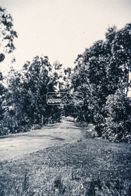
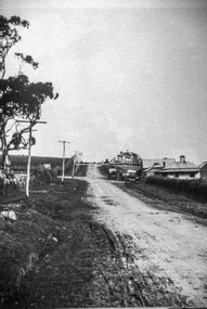
Slide, Main Road, Lower Plenty, 25 Jul 1973
... Main Road, Lower Plenty... at Bolton Street. Main Road, Lower Plenty underwent substantial... melbourne Slide Slide Main Road, Lower Plenty 35 mm colour positive ...This section of Main Road was known by locals as the "Windy Mile" due to its many little wists and turns. It was also the setting for Billy Cart derbies held on special occassions such as the Eltham Easter Gymkhana at Eltham Lower Park. Contestants would line up and race each other down the hill to the finish line at Bolton Street. Main Road, Lower Plenty underwent substantial changes when it was duplicated with the road becoming two lanes each way and split level due to the cross gradient. This particular section running down the hill from Panorama Avenue to Bolton Street with its twists and turns had many of them straightened out during the road widening constuction work.35 mm colour positive transparency Mount - Agfacolor Service (Blue)main road, infrastructure, lower plenty, roads, windy mile -
 Eltham District Historical Society Inc
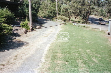
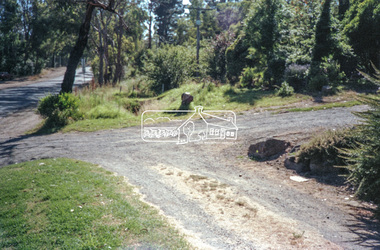
Slide, In front of Martin property drive on Bonds Road looking east up Montpelier Drive, Lower Plenty, 18 July 1972, 1972
Water drainage work undertaken by Eltham Shire Council in Bonds Road, Lower Plenty outside the Martin property opposite Montpelier Drive, July 197235 mm colour positive transparency Mount - Agfacolor Service (Blue)Bonds Road (Martin property) 12.10 pm 18.7.72bonds road, drainage works, eltham shire council, infrastructure, lower plenty, martin property, montpelier drive