Showing 1469 items matching "mitchell street"
-
 Bendigo Historical Society Inc.
Photograph - T C WATTS & SON COLLECTION: MARKS STREET, BENDIGO, 1929
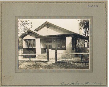
... Street Bendigo Frank A. Jeffree Bendigo Black and white photographs (2) mounted on rectangular brown board. House, stained weatherboard board to sill height, rough cast above, bow lead- light window on right, leadlight windows on left, louvred vents to both front gables, tiled roof, roughcast verandah surround and pillars, 3 steps to veranda level, one chimney visible, small white veranda lamp, woven wire fence. Gate wooden gateway with lintel. On back of photo 18a: 'Sold Balsillie £875 sewered, or £825 plus sewerage. Stamp with T.C. Watts & Son, 253 Mitchell ...Andrew Balsillie (30/8/1874-28/7/1949. For 50 years he was associated with the Bendigo Mutual Permenant Land and Building Society and was its secretary from 1916 to 1945. He was the son of Andrew and Maria (nee Laing), who operated Edinburgh House selling ladies and gentlemen's clothing. Andrew Jnr. married Helen (Nellie) Calder in 1903.Black and white photographs (2) mounted on rectangular brown board. House, stained weatherboard board to sill height, rough cast above, bow lead- light window on right, leadlight windows on left, louvred vents to both front gables, tiled roof, roughcast verandah surround and pillars, 3 steps to veranda level, one chimney visible, small white veranda lamp, woven wire fence. Gate wooden gateway with lintel. On back of photo 18a: 'Sold Balsillie £875 sewered, or £825 plus sewerage. Stamp with T.C. Watts & Son, 253 Mitchell St., Bendigo., 12 April, 1929' On back of 18b. A. Balsillie, Marks St., £950 (crossed out ) £875, sewered or £825 plus sewerage.' May 1929.Frank A. Jeffree Bendigobuilding, residential, t.c. watts and son, balsillie, marks street bendigo -
 Bendigo Historical Society Inc.
Document - GUINEY COLLECTION: DENTON BROS ACCOUNT RENDERED
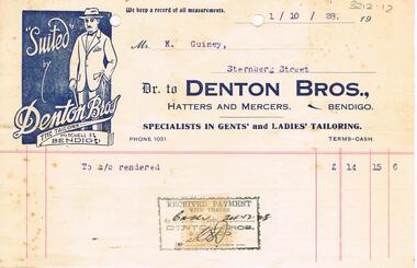
... Street, Bendigo, for £14/15/6. Rectangle with blue infill with 'Suited by Denton Bros, the tailors, Mitchell St Bendigo' with man drawn wearing suit and top hat, in top LH of letterhead....Street, Bendigo, for £14/15/6. Rectangle with blue infill with 'Suited by Denton Bros, the tailors, Mitchell St Bendigo' with man drawn wearing suit and top hat, in top LH of letterhead. ...Account rendered issued by Denton Bros., Haters and Mercers, Bendigo to Mr. K. Guiney, Sternberg Street, Bendigo, for £14/15/6. Rectangle with blue infill with 'Suited by Denton Bros, the tailors, Mitchell St Bendigo' with man drawn wearing suit and top hat, in top LH of letterhead.bendigo, business, denton bros hatters and mercers -
 Bendigo Historical Society Inc.
Book - AILEEN AND JOHN ELLISON COLLECTION: SIXTEEN EXPLORERS OF AUSTRALIA
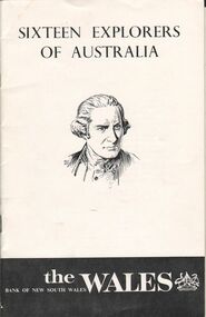
... Street Bendigo goldfields BOOKS Biography Explorers of Australia Small booklet: Sixteen Explorers of Australia. A portrait of Captain Cook on the front page. It was published in March 1965 by the Bank of New South Wales. The booklet has 17 pages. Contents: Preface - Abel Tasman - James Cook - George Bass - Matthew Flinders - Gregory Blaxland - John Oxley - Phillip Parker King - Charles Sturt - Thomas Livingstone Mitchell - Edward John Eyre - Ludwig Leichardt - Augustus Charles Gregory - Edmund Kennedy - Robert O'Hara Burke - John McDouall Stuart - John Forrest. ...Small booklet: Sixteen Explorers of Australia. A portrait of Captain Cook on the front page. It was published in March 1965 by the Bank of New South Wales. The booklet has 17 pages. Contents: Preface - Abel Tasman - James Cook - George Bass - Matthew Flinders - Gregory Blaxland - John Oxley - Phillip Parker King - Charles Sturt - Thomas Livingstone Mitchell - Edward John Eyre - Ludwig Leichardt - Augustus Charles Gregory - Edmund Kennedy - Robert O'Hara Burke - John McDouall Stuart - John Forrest.books, biography, explorers of australia -
 Bendigo Historical Society Inc.
Photograph - PALL MALL 1861, 1861
... History House 11 Mackenzie Street Bendigo goldfields PLACE Streetscape pall mall Batchelder, Sandhurst black and white photograph - copy of original: streetscape of Pall Mall showing Bank of Australasia at left ( on corner of Williamson St. with Batchelder's photographer handcart in front. From left to right Bank of Australasia, 'Rowkirk & Co. ' on curved parapet. Shows Pall Mall from corner of William St. at left towards Mitchell ...black and white photograph - copy of original: streetscape of Pall Mall showing Bank of Australasia at left ( on corner of Williamson St. with Batchelder's photographer handcart in front. From left to right Bank of Australasia, 'Rowkirk & Co. ' on curved parapet. Shows Pall Mall from corner of William St. at left towards Mitchell St. off the RH side of image.Batchelder, Sandhurstplace, streetscape, pall mall -
 Bendigo Historical Society Inc.
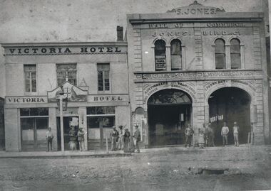
Photograph - VICTORIA HOTEL AND JONES BIRD & CO, BENDIGO, 1861
... History House 11 Mackenzie Street Bendigo goldfields BUILDINGS Commercial Batchelder Black and white copy: two buildings adjoining with assorted males grouped on footpath and doorways. Victoria Hotel and Jones Bird & Co., Pall Mall, Bendigo between Mitchell ...Black and white copy: two buildings adjoining with assorted males grouped on footpath and doorways. Victoria Hotel and Jones Bird & Co., Pall Mall, Bendigo between Mitchell St. & Williamson St., Victoria Lane beside hotel. Victorian coat of arms on doorway. ( James Lerk 22.9.2000 ). On window 'Edward Francis/Ward/Attorney at Law/& solicitor' S. Jones and Sons, L. McPherson & Co. ' Auctioneers, Valuators/Land Estate Commission Agents' ' Livery Bait and Commission Yards ' ' Horses Carriages & Dog Carts…/ Horses Broken, Double and single harness '.Batchelderbuildings, commercial -
 Bendigo Historical Society Inc.
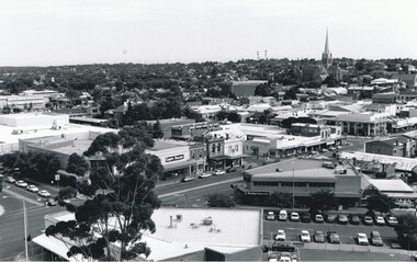
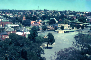
Photograph - AERIAL VIEW BENDIGO, 1995
... Pauls's, Mitchell St. in foreground ( left to right ) Wills St. on RHS ( to distance ) and Garsed St. on LHS ( to distance ) Edwards St. ( next street parallel to Mitchell St...History House 11 Mackenzie Street Bendigo goldfields PLACE Aerial view of bendigo Peter Hyett Black and white photograph: city skyline taken from St. Pauls's, Mitchell ...Black and white photograph: city skyline taken from St. Pauls's, Mitchell St. in foreground ( left to right ) Wills St. on RHS ( to distance ) and Garsed St. on LHS ( to distance ) Edwards St. ( next street parallel to Mitchell St. ( Noelene Wild 7.2000 )Peter Hyettplace, aerial view of bendigo -
 Bendigo Historical Society Inc.
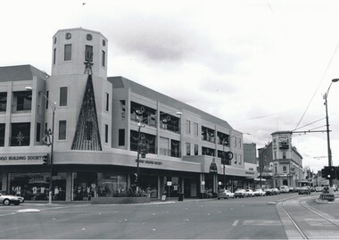
Photograph - BENDIGO BUILDING SOCIETY: CHARING CROSS, 1995
... History House 11 Mackenzie Street Bendigo goldfields BUILDINGS Commercial bendigo building society Peter Hyatt, 1995 Black and white photo: Bendigo building society, corner High and Mitchell St. with Christmas decorations ( later Bendigo Bank building ) City Family Hotel, centre rear. ...Black and white photo: Bendigo building society, corner High and Mitchell St. with Christmas decorations ( later Bendigo Bank building ) City Family Hotel, centre rear. B 10 in black lead pencil on rear.Peter Hyatt, 1995buildings, commercial, bendigo building society -
 Bendigo Historical Society Inc.
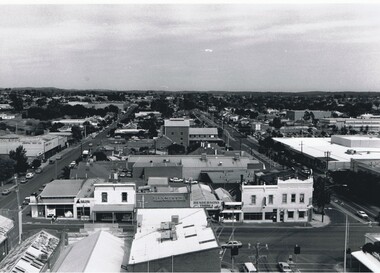
Photograph - AERIAL VIEW OF BENDIGO, 1995
... History House 11 Mackenzie Street Bendigo goldfields PLACE Aerial view of bendigo Peter Hyett Black and white photo: view of Bendigo with Mitchell St. from centre left to centre. ...Black and white photo: view of Bendigo with Mitchell St. from centre left to centre. Shows Sacred Heart Cathedral at left. Coles supermarket carpark in foreground. Dome of RSL in Pall Mall in front of trees to right. On back C 26A. Noelene Wild July 2000 ' photo by Peter Hyett 1995 from St. Paul's Myer St., Sacred Heart Cathedral at left.'Peter Hyettplace, aerial view of bendigo -
 Bendigo Historical Society Inc.
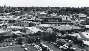
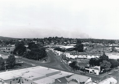
Photograph - AERIAL VIEW OF BENDIGO, 1995
... History House 11 Mackenzie Street Bendigo goldfields COTTAGE Miners Peter Hyett Black and white photograph taken from St. Paul's, Mitchell runs from left corner. ...Black and white photograph taken from St. Paul's, Mitchell runs from left corner. Cathedral spire in centre. T.V. towers in background. Central Deborah poppet head far left ? Ian Wild 7.2000 ' photo - Peter Hyett 1995 - ? From St. Paul's. Mitchell St. runs across photo - intersection with Edwards St. on left ';Peter Hyettcottage, miners -
 Bendigo Historical Society Inc.
Photograph - BENDIGO RAILWAY STATION: AERIAL VIEW, 1995
... History House 11 Mackenzie Street Bendigo goldfields PLACE Aerial view of bendigo bendigo railway station Peter Hyett 1995 Black and white photo: aerial view looking trowards Bendigo Railway Station. Mitchell ...Black and white photo: aerial view looking trowards Bendigo Railway Station. Mitchell st. runs across lower part of photo. Photo taken prior to building of 'Market place' shopping centre. A 16A black lead on rear.Peter Hyett 1995place, aerial view of bendigo, bendigo railway station -
 Bendigo Historical Society Inc.
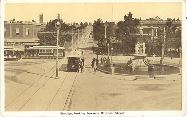
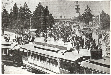
Photograph - BASIL MILLER COLLECTION: 3 TRAMS AT CHARRING CROSS
... History House 11 Mackenzie Street Bendigo goldfields BHS Collection PERSON Individual basil miller Bendigo, 3 trams at Charing Cross, view looking up Mitchell St. ...BHS CollectionBendigo, 3 trams at Charing Cross, view looking up Mitchell St. City Club Hotel (centre right), Alexandra Fountain (right), Emery and Gibson Corner (centre left).person, individual, basil miller -
 Bendigo Historical Society Inc.
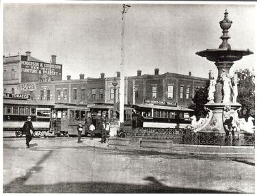
Photograph - BASIL MILLER COLLECTION: PHOTOGRAPHIC COPY OF CHARING CROSS, Between 1892 - 1903
... History House 11 Mackenzie Street Bendigo goldfields BHS Collection PERSON Individual basil miller A. Doney Black and white photo copy of Businesses on Pall Mall and Mitchell St corner. ...BHS CollectionBlack and white photo copy of Businesses on Pall Mall and Mitchell St corner. Alexandra fountain on right. 2 steam trams and trailers on left. J.T. Hill - Tailor (No. 8 Pall Mall), Van Dam's- Tobacconist (No. 4 Pall Mall). 'Photo by A. Doney, Bendigo' stamped on back.A. Doneyperson, individual, basil miller -
 Bendigo Historical Society Inc.
Photograph - BASIL MILLER COLLECTION: PHOTOGRAPHIC COPY OF TRAM ON MOLLISON AND MITCHELL ST
... History House 11 Mackenzie Street Bendigo goldfields BHS Collection PERSON Individual basil miller Steam tram turning off Mollison St into Mitchell St, railway place and station visible in background. ...BHS CollectionSteam tram turning off Mollison St into Mitchell St, railway place and station visible in background. After 1892, note ''Bendigo'' written on Grocers cart (centre left). Advertising on tram for Yankee Doodle Tobacco? from ''The Bendigonian'' by courtesy of The LaTrobe Library written on back in blue ink. 'P.3. B?th?? 5 Col.' written in black ink on back top right hand corner.person, individual, basil miller -
 Bendigo Historical Society Inc.
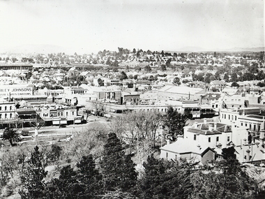
Photograph - BENDIGO LANDSCAPE 1937, 1937
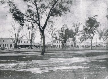
... History House 11 Mackenzie Street Bendigo goldfields PLACE Landscape view bendigo black and white photo: view of Bendigo CBD from lookout tower looking east of south towards Railway Station, shows Sandhurst Club at bottom right corner, Queen Victoria statue in gardens, intersection of Pall Mall, Mitchell and View Strets. ...black and white photo: view of Bendigo CBD from lookout tower looking east of south towards Railway Station, shows Sandhurst Club at bottom right corner, Queen Victoria statue in gardens, intersection of Pall Mall, Mitchell and View Strets. In image ' ...rley Johnsons ' Mathews Bros' ' Plume' ' Plaza' ' A.E. Sayer' On back ' Bendigo, Victoria, 1937, Ellison Coll'place, landscape view, bendigo -
 Bendigo Historical Society Inc.
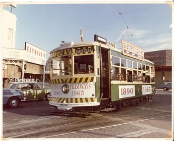
Photograph - BASIL MILLER COLLECTION: TRAM ON MITCHELL ST 75TH ANNIVERSARY, 1960
... History House 11 Mackenzie Street Bendigo goldfields BHS Collection PERSON Individual basil miller Colour photo showing tram turning right off Mitchell St onto Pall Mall, taken in 1965, 75th anniversary of Bendigo Tramways. ...BHS CollectionColour photo showing tram turning right off Mitchell St onto Pall Mall, taken in 1965, 75th anniversary of Bendigo Tramways. On back 'Copyright by the Tramway Museum Society of Victoria' stamped in purple ink, pencil marks showing '22/8'.person, individual, basil miller -
 Bendigo Historical Society Inc.
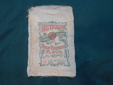
Textile - FLOUR BAG COLLECTION: WITTSCHEIBE BROS, BENDIGO, 1900-1950
... Street Bendigo goldfields TEXTILES Domestic Wittscheibe Bros Bendigo. Flour bag Textiles. Linen flour bag printed on both sides in red and green.1. ''WITTSCHEIBE BROS. The famous WB Brand Regd. World's Best Self Raising Flour prepared from the choicest Victorian wheat. Factory 172 MITCHELL ...Textiles. Linen flour bag printed on both sides in red and green.1. ''WITTSCHEIBE BROS. The famous WB Brand Regd. World's Best Self Raising Flour prepared from the choicest Victorian wheat. Factory 172 MITCHELL ST>< BENDIGO< 5 lbs''. Side 1 printed in black ink KA No 712. Side 2 printed in pen ink 1149. 5lbs net. Self raising Flour W.B. Brand Self Raising Flour is mixed and prepared from the choicest Victorian grown wheat, and possessing highly nutritious qualities is unequalled for Scones, Cakes, Puddings, ETC 172 Mitchell St., Bendigo, Telephone 339''.textiles, domestic, wittscheibe bros, bendigo. flour bag -
 Bendigo Historical Society Inc.
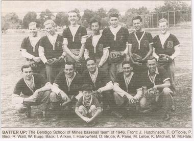
Newspaper - JENNY FOLEY COLLECTION: BATTER UP
... Street Bendigo goldfields NEWSPAPER Bendigo advertiser the way we were Bendigo Advertiser "The way we were" from Thursday, May 5, 2005. Batter up: the Bendigo School of Mines baseball team of 1946. Front: J. Hutchinson, T. O'Toole, P. Birol, R. Watt, W. Bugg. Back: I. Aitken, I. Harrowfield, D. Bruce, A. Pane, M. Lefoe, K. Mitchell ...Bendigo Advertiser "The way we were" from Thursday, May 5, 2005. Batter up: the Bendigo School of Mines baseball team of 1946. Front: J. Hutchinson, T. O'Toole, P. Birol, R. Watt, W. Bugg. Back: I. Aitken, I. Harrowfield, D. Bruce, A. Pane, M. Lefoe, K. Mitchell, M. McHale.newspaper, bendigo advertiser, the way we were -
 Bendigo Historical Society Inc.
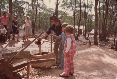
Photograph - ROY J MITCHELL COLLECTION: SANDHURST TOWN, BENDIGO
... History House 11 Mackenzie Street Bendigo goldfields BENDIGO Tourism Sandhurst Town Roy J Mitchell Colour photograph. ...Colour photograph. Image shows two children looking at a gold cradle at Sandhurst Town, Bendigo. Man, dressed as miner, operating cradle. Written on back '10 March '80. Sandhurst Town Bendigo, Goldrush Gully Mine. 'Strike it Rich' 10.3.1980. Sandhurst Town near Bendigo, Vic by Roy J. Mitchell.Roy J Mitchellbendigo, tourism, sandhurst town -
 Bendigo Historical Society Inc.
Photograph - ROY J MITCHELL COLLECTION: LANDSCAPE PHOTO FROM POPPET HEAD ROSALIND PARK
... History House 11 Mackenzie Street Bendigo goldfields BENDIGO Streetscape Queen Elizabeth Oval Roy J Mitchell Colour photograph. ...Colour photograph. Image shows Bendigo landscape view, looking north west from lookout tower, Rosalind Park. Queen Elizabeth Oval and grandstand in foreground. Written on back of photo: Bendigo Jan 1972, Queen Park Oval from lookout tower, January 1972 by Roy J Mitchell'Roy J Mitchellbendigo, streetscape, queen elizabeth oval -
 Bendigo Historical Society Inc.
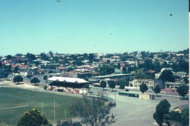
Photograph - ROY J MITCHELL COLLECTION: VIEW FROM LOOKOUT TOWER, QUEEN ELIZABETH OVAL, BENDIGO
... Written on back of photo ' Jan 1972, Bendigo from Lookout Tower, Pall Mall (not accurate, should be View Street) towards Golden Square, by Roy J Mitchell'...History House 11 Mackenzie Street Bendigo goldfields BENDIGO Streetscape Queen Elizabeth Oval Roy J Mitchell Colour photograph taken from lookout tower, Queen Elizabeth Oval, Bendigo, looking south west. ...Colour photograph taken from lookout tower, Queen Elizabeth Oval, Bendigo, looking south west. View Street centre field, QEO carpark and Art Gallery buildings in foreground. Written on back of photo ' Jan 1972, Bendigo from Lookout Tower, Pall Mall (not accurate, should be View Street) towards Golden Square, by Roy J Mitchell'Roy J Mitchellbendigo, streetscape, queen elizabeth oval -
 Bendigo Historical Society Inc.
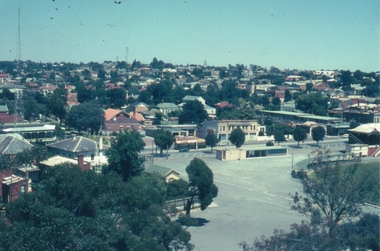
Photograph - ROY J MITCHELL COLLECTION: VIEW FROM LOOKOUT TOWER, QUEEN ELIZABETH OVAL, BENDIGO
... History House 11 Mackenzie Street Bendigo goldfields BENDIGO Streetscape Queen Elizabeth Oval Roy J Mitchell Colour photograph taken from lookout tower, Queen Elizabeth Oval, Bendigo, looking southeast. ...Colour photograph taken from lookout tower, Queen Elizabeth Oval, Bendigo, looking southeast. Rifle Brigade Hotel on extreme RH side, carpark behind Art Gallery complex in centre of image. Written on back :'January 1972, Bendigo, Victoria. From Lookout Tower'Roy J Mitchellbendigo, streetscape, queen elizabeth oval -
 Bendigo Historical Society Inc.
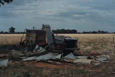
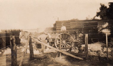
Photograph - ROY J MITCHELL COLLECTION: SEED DRILL GOORNONG
... History House 11 Mackenzie Street Bendigo goldfields AGRICULTURE Machinery Seed drill Roy J Mitchell Colour photograph of farm machinery in paddock near Goornong. ...Colour photograph of farm machinery in paddock near Goornong. Machinery is in a dilapidated condition. Written on back : '29.3.96' farm machinery (seed drill) near Goornong Victoria 14.30 hrs, 29.3.1996 by Roy J Mitchell, Bendigo'Roy J Mitchellagriculture, machinery, seed drill -
 The Beechworth Burke Museum
Photograph, R & M Harvey
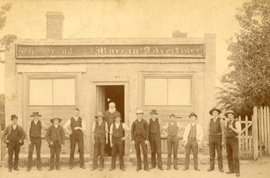
... Street...richard warren...journalism...advertising...1800s...1800s Beechworth...#beechworth...local business...advertiser...workmen...hats...printers...journalists...Warren...mary ann mitchell...Mitchell when he was twenty-six, and, while the couple were unable to have children, they adopted one son, who began managing the Advertiser in the late-nineteenth century. This photograph has historic significance afor its relationship to the history of the Ovens and Murray Advertiser, which is a key example of of successful nineteenth-century business in Beechworth, and for including an image of Richard Warren, a key figure in the period. Ovens and Murray advertiser the ovens and murray advertiser Newspaper printing Ford Street ...This photograph shows a group of men standing outside the Ford Street office of the Ovens and Murray Advertiser in Beechworth. This group includes the Advertiser''s manager, Richard Warren, who is bearded man standing in the doorway and who's name is written on the reverse of the photograph. The Advertiser was a local paper, first printed as a weekly in 1855, and then as a daily in 1857. It continues to be printed today, albeit in a different form. The Advertiser was launched by architect Francis Hodgson Nixon with assistance from businessman John Henry Gray, and newspaperman Richard Warren. Warren was sole owner from 1860 until his death in 1906, and it responsible for much of the paper’s success. Its goals included coverage of local events, as well as of global news, and the promotion of economic liberty, arts, and sciences. Beyond these initial goals, the Advertiser was instrumental in local politics, particularly Beechworth’s association with conservatism and constitutionalism in the 1860s and 1870s. Numerous other papers sprung up to contest the Advertiser’s hold during the latter half of the nineteenth-century, but none were able to completely oust it from its post. As well as representing a key chapter in Beechworth’s history, the Advertiser can be used as a key source for the stories and figures of historic Beechworth. As well as managing the Advertiser, Richard Warren's owned or managed multiple businesses in Beechworth, founded the Ovens hospital and Benevolent asylum, invested in local companies, and participated in a range of religious brotherhoods and societies. He married Mary Ann Mitchell when he was twenty-six, and, while the couple were unable to have children, they adopted one son, who began managing the Advertiser in the late-nineteenth century. This photograph has historic significance afor its relationship to the history of the Ovens and Murray Advertiser, which is a key example of of successful nineteenth-century business in Beechworth, and for including an image of Richard Warren, a key figure in the period. Sepia rectangular photograph, faded, printed on photographic material and mounted on board. Obverse: The Ovens and Murray Advertiser Reverse: Or M A/ Printing Office/ Ford Street About 1860/ Beechworth/ R Warren [logo: R & M Harvey/Authorised Newsagents/ and Gift Shop/ Beechworth Phone 114]ovens and murray advertiser, the ovens and murray advertiser, newspaper, printing, ford street, richard warren, journalism, advertising, 1800s, 1800s beechworth, #beechworth, local business, advertiser, workmen, hats, printers, journalists, warren, mary ann mitchell, mary ann warren, 1860s, 1860s beechworth, r warren, r & m harvey -
 The Beechworth Burke Museum
Photograph, c1900
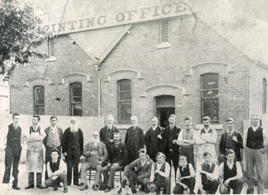
... mitchell...mary ann warren...R Warren...loch street...Ovens and Murray advertiser the ovens and murray advertiser Newspaper printing richard warren journalism advertising 1800s 1800s Beechworth #beechworth local business advertiser workmen hats printers journalists Warren mary ann mitchell mary ann warren R Warren loch street 1890s 1890s Beechworth Obverse: Ovens and Murray/ Printing Office Reverse: Ovens and Murray Advertiser Staff 7721/ Beechworth/ BMM 79.15 Rectangular black and white photo printed on photographic material, unmounted. ...This photograph shows a group of workmen outside the Loch Street Printing Office of the Ovens and Murray Advertiser in Beechworth. The Advertiser was a local paper, first printed as a weekly in 1855, and then as a daily in 1857. It continues to be printed today, albeit in a different form. Initially based on Ford Street, the Loch Street office opened in 1893, after printing facilities were updated. The Advertiser was launched by architect Francis Hodgson Nixon with assistance from businessman John Henry Gray, and newspaperman Richard Warren. Warren was sole owner from 1860 until his death in 1906, and it responsible for much of the paper’s success. He appears in this photo alongside twenty of his staff and is the man standing directly in front of the doorway. When it launched, the paper’s goals included coverage of local events, as well as of global news, and the promotion of economic liberty, arts, and sciences. Beyond these initial goals, the Advertiser was instrumental in local politics, particularly Beechworth’s association with conversates and constitutionalism in the 1860s and 1870s. Numerous other papers sprung up to contest the Advertiser’s hold during the latter half of the nineteenth-century, but none were able to completely oust it from its post. As well as representing a key chapter in Beechworth’s history, the Advertiser can be used as a key source for the stories and figures of historic Beechworth. As well as managing the Advertiser, Richard Warren's owned or managed multiple businesses in Beechworth, founded the Ovens hospital and Benevolent asylum, invested in local companies, and participated in a range of religious brotherhoods and societies. He married Mary Ann Mitchell when he was twenty-six, and, while the couple were unable to have children, they adopted one son, who began managing the Advertiser in the late-nineteenth century. This photograph has historic significance afor its relationship to the history of the Ovens and Murray Advertiser, which is a key example of of successful nineteenth-century business in Beechworth, and for including an image of Richard Warren, a key figure in the period.Rectangular black and white photo printed on photographic material, unmounted. Obverse: Ovens and Murray/ Printing Office Reverse: Ovens and Murray Advertiser Staff 7721/ Beechworth/ BMM 79.15ovens and murray advertiser, the ovens and murray advertiser, newspaper, printing, richard warren, journalism, advertising, 1800s, 1800s beechworth, #beechworth, local business, advertiser, workmen, hats, printers, journalists, warren, mary ann mitchell, mary ann warren, r warren, loch street, 1890s, 1890s beechworth -
 The Beechworth Burke Museum
Postcard, George Symons, c.1990
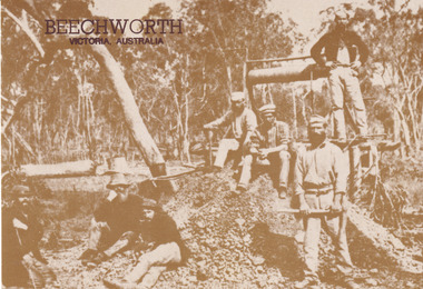
... The Beechworth Burke Museum Loch Street Beechworth high-country The photograph printed on this postcard comes from the collection of the Mitchell Library in Sydney. ...The photograph printed on this postcard comes from the collection of the Mitchell Library in Sydney. It is sepia in tone and depicts seven men standing and sitting around a mine shaft in the Beechworth region. The photograph has been dated to approximately 1872. This period in history post-dates the Victorian gold rushes which occurred 1852-1853 in Ballarat, Bendigo and Beechworth. During this period, in the 1870s, the surface alluvial gold had been discovered and removed from location. Therefore, in order to reach the deeper and less accessible alluvial gold, diggers began to dig shafts into the earth. These shafts sunk below the ground level by 20 to 30 feet and required timber structures around the entrance and winches to bring the paydirt to the top. The top of this wooden structure is visible behind the man standing in the upper right of the image. This type of mining was highly dangerous as mines often caved in which injured the minors and often resulted in death. Thus, following this period, in the early 1900s, miners opted instead for hydrolic slucing which cut away the earth without the devastating consequences of a mine cave in. This particular group of miners appear to have been unable to afford a horse (then worth around 50 pounds) which were generally used at mines like this to help pull buckets attached to ropes up and down the mine. Instead, this group brought the buckets up and down by windlass. The windlass was a wooden structure mounted over the mining shaft and fitted with a hand-cranked winch which enabled the bucket attached to the rope to be brought up and down.Gold was first discovered in Beechworth in Spring and Reid's Creek in the summer of 1852-1853. At its popularity, this region had approximately 8000 people on the gold fields searching for gold on the banks of these creeks. These periods did not require the use of heavy machinery or the digging of deep mining shafts like the one depicted in this image. Therefore, this image has important connotations for the technologies associated with mining during the approximated 1870s when gold was harder to access. This is a later period in gold history which does not fit into the "gold rush" period. Instead, it occurred after the surface gold had disappeared and therefore, is essential for researchers who are investigating the mining techniques and structures used to reach the alluvial gold which was located deeper under ground in the 1870s. This period predates the use of big heavy machinery used to mine in the 1900s which include dredges. Images such as this one can also impart essential information as to the wardrobe and fashion of men during this period. It also imparts knowledge about the landscape of Beechworth which is useful for people researching the environment and impact of gold mining in the north-east region of Victoria. In addition, since this image is a postcard reproduction of an early Australian image which may date to approximately 1990 it can impart knowledge as to the interests of people during this time period when there may have been an increase into Australian history.A sepia tone facsimile of an early Australian photograph (circa 1872) printed as a postcard.Obverse: BEECHWORTH / Victoria, Australia / Reverse: GM 2 3275 / CORRESPONDENCE / AUSTRALIAN / YESTERYEAR / CARDS / ADDRESS / Published by George Symons (057) 65 3240 / THE MINEHEAD C. 1872 / The easily gleaned gold of the early fields did / not last very long. In order to reach less / accessible alluvial gold diggers began sinking shafts as much as twenty to thirty feet down / and the mines required timbering and winches / to bring the paydirt to the top. / This syndicate has been unable to afford the / luxury of a horse (about 50 pounds) and so everything / must go up and down by windlass and rawhide / bucket. / Photo: Mitchell Library, Sydney / A sepia tone facsimile of / an early Australian photographmining album, gold mine, beechworth, burke museum, mine shaft, postcard, australian yesteryear cards, george symons, the minehead, gold fields, alluvial gold, early australia, c.1872, 1872, gold diggers, north east victoria -
 Greensborough Historical Society
Article, Cherel Sartori, Kell's Cottage by Cherel Sartori, 1917o
... Story of Kell's Cottage, built 1917, at 112 Henry Street Greensborough by William Mitchell on the 60 acre dairy farm owned by Ethel and Walter Kell. ...Greensborough Historical Society 34A Glenauburn Road Lower Plenty Lower Plenty melbourne Story of Kell's Cottage, built 1917, at 112 Henry Street Greensborough by William Mitchell on the 60 acre dairy farm owned by Ethel and Walter Kell. ...Story of Kell's Cottage, built 1917, at 112 Henry Street Greensborough by William Mitchell on the 60 acre dairy farm owned by Ethel and Walter Kell. This account was written by Cherel Sartori (who owned the house from 1990-2000), following a visit by Claude Amiet who lived in the house as a child in the early 20th century.12 p., text and sepia and col. photographskell's cottage, claude amiet, cherel sartori -
 Greensborough Historical Society
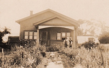
Photograph - Digital Image, Cherel Sartori, Kell's Cottage, 01/01/1956
... The house was built 1917, at 112 Henry Street Greensborough by William Mitchell on the 60 acre dairy farm owned by Ethel and Walter Kell. ...The house was built 1917, at 112 Henry Street Greensborough by William Mitchell on the 60 acre dairy farm owned by Ethel and Walter Kell. ...Photograph of Kell's Cottage. The house was built 1917, at 112 Henry Street Greensborough by William Mitchell on the 60 acre dairy farm owned by Ethel and Walter Kell. This collection of photographs was copied by Cherel Sartori (who owned the house from 1990-2000), following a visit by Claude Amiet who lived in the house as a child in the early 20th century.Digital copy of black and white photographkell's cottage, claude amiet, cherel sartori -
 Greensborough Historical Society
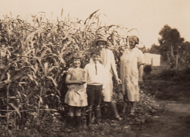
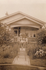
Photograph - Digital Image, Cherel Sartori, Claude Amiet at Kell's Cottage 1920s, 1920c
... The house was built 1917, at 112 Henry Street Greensborough by William Mitchell on the 60 acre dairy farm owned by Ethel and Walter Kell. ...The house was built 1917, at 112 Henry Street Greensborough by William Mitchell on the 60 acre dairy farm owned by Ethel and Walter Kell. ...Photograph of Claude Amiet and others at Kell's Cottage in the 1920s. The house was built 1917, at 112 Henry Street Greensborough by William Mitchell on the 60 acre dairy farm owned by Ethel and Walter Kell. This collection of photographs was copied by Cherel Sartori (who owned the house from 1990-2000), following a visit by Claude Amiet who lived in the house as a child in the early 20th century.Digital copy of black and white photographkell's cottage, claude amiet, cherel sartori -
 Greensborough Historical Society
Photograph - Digital Image, Cherel Sartori, Kell's Cottage 1940s, 01/01/1956
... The house was built 1917, at 112 Henry Street Greensborough by William Mitchell on the 60 acre dairy farm owned by Ethel and Walter Kell. ...The house was built 1917, at 112 Henry Street Greensborough by William Mitchell on the 60 acre dairy farm owned by Ethel and Walter Kell. ...Photograph of Kell's Cottage in the 1940s. The house was built 1917, at 112 Henry Street Greensborough by William Mitchell on the 60 acre dairy farm owned by Ethel and Walter Kell. This collection of photographs was copied by Cherel Sartori (who owned the house from 1990-2000), following a visit by Claude Amiet who lived in the house as a child in the early 20th century.Digital copy of black and white photographkell's cottage, claude amiet, cherel sartori -
 Greensborough Historical Society
Photograph - Digital Image, Cherel Sartori, Kell's Cottage, 01/01/1956
... The house was built 1917, at 112 Henry Street Greensborough by William Mitchell on the 60 acre dairy farm owned by Ethel and Walter Kell. ...The house was built 1917, at 112 Henry Street Greensborough by William Mitchell on the 60 acre dairy farm owned by Ethel and Walter Kell. ...Photographs of Kell's Cottage in the 1940s. The house was built 1917, at 112 Henry Street Greensborough by William Mitchell on the 60 acre dairy farm owned by Ethel and Walter Kell. This collection of photographs was copied by Cherel Sartori (who owned the house from 1990-2000), following a visit by Claude Amiet who lived in the house as a child in the early 20th century.Digital copy of 3 black and white photographkell's cottage, claude amiet, cherel sartori