Showing 116790 items
matching orbost-brodribb-road
-
 Lakes Entrance Regional Historical Society (operating as Lakes Entrance History Centre & Museum)
Book, Kastelein, Peter, Bairnsdale to Orbost Railway - Paper and Discussion, 2000
Wartime reminiscences of a young boy experiencing the Second World War in Holland during German occupation. Lack of food, fuel and electricity meant that survival was the predominant daily concern.world war 1939 - 1945, holland -
Lakes Entrance Regional Historical Society (operating as Lakes Entrance History Centre & Museum)
Book, Mc Adam, Angela; Ruhfus, Margaret; Bagnall, Kate; Gil, Rob, Orbost StateSchool No 2744 A-H, 2007
A handbook explaining the principles of establishing and managing archives, written in plain English for Australian historical groups, schools, sports clubs, cultural groups and any group wishing to organise its records and holdings.archives -
Lakes Entrance Regional Historical Society (operating as Lakes Entrance History Centre & Museum)
Book, Orbost State School No 2744 I -Z
Enrolment details of each student registered, including parents info from 1934-1995schools, occupation -
Lakes Entrance Regional Historical Society (operating as Lakes Entrance History Centre & Museum)
Book, Orbost North State School No 4767
Enrolment details of each student registered, including parents info from 1934 - 1995schools, occupation -
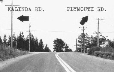 Ringwood and District Historical Society
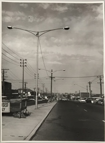
Photograph, Intersection of Kalinda Road and Plymouth Rd. Ringwood 1967
B&W Photograph with road names and arrows added.Catalogue card reads, "Intersection of Kalinda Road and Plymouth Rd. 1967". -
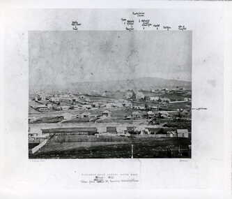 Clunes Museum
Photograph, BALLARAT ROAD, CLUNES, SOUTH WEST, 1865
PHOTOGRAPH SHOWS MANSE PREBYTERIAN [ST ANDREWS[ CHURCH METHODIST [WESLEY[ WITHOUT SPIRE, SUNDAY SCHOOL AND PARSONAGE MARKET, POST OFFICE SITE TOWN HALL PHOTOGRAPH OF BALLARAT ROAD [SERVICE STREET] CLUNES. PHOTOGRAPH TAKEN FROM GEORGE STREET TOWARDS SMEATON ROAD. .1 SEPIA PHOTOGRAPH MOUNTED, WITH POINTS OF INTEREST NOTED AROUND EDGE. PERIOD 1865 .2 BLACK AND WHITE PHOTO PRINT .3 SMALL BLACK AND WHITE PHOTO PRINTBALLARAT ROAD, CLUNES, SOUTH WESTphotography, photographs, township, churches -
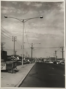 Kew Historical Society Inc
Photograph, Stuart Tompkins Studio, Electricity Supply Poles, South Road, Moorabbin, 1965
Research provided by Stuart Tompkins Studio, Box Hill, into alternatives for median strip street lighting to be used in Burke Road, Kew. The photographers identified variants in different suburbs appropriate to Kew's needs.The series from which the photograph is drawn provides a snapshot by a commercial photographic studio of each named vicinity in 1965 as well as providing examples of public works infrastructure being commissioned by local government in the 1960s. The photos originally formed part of the Engineering Department's files in the City of Kew before being donated to the kew Historical Society.Electricity Supply Poles, South Road, Moorabbin, 1965. Stuart Tompkins Studio provided this photograph for the Kew City Council. The photograph of South Road, Moorabbin, west of Jasper Road, looking east depicts steel poles with two lamps in a median strip and supply wires from pole to pole. The poles were described as 100′ apart. The notation on the rear of the photograph was that there were lamps along the median strip except at intersections. A wooden pole is recognised as supporting heavy supply lines across the road. The steel poles in the photograph were said to be between 3′ to 3.5′ whereas the wooden poles were three to 12.25″ in diameter. [There are three copies of this photograph in the Collection.] Typed inscription on reverse: "Electricity Supply Poles. Photographed for Kew City Council 8/2/65. No.2 South Road - Moorabbin, west of Jasper Road, looking east. Steel poles with two lamps in median strip and supply wires from pole to pole along median strip (poles only 100' apart). Lamps along median only except at intersections. Wooden pole supports heavy supply lines across the road. Wooden poles 3' up and 8 1/2" dia. Wooden poles 3' up and 12 1/2 dia." Studio stamp: "Stuart Tompkins Studio. 547 Station Street, Box Hill. WX1439."public infrastructure -- kew (vic.), city of kew - engineers department -
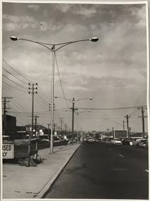 Kew Historical Society Inc
Photograph, Stuart Tompkins Studio, Electricity Supply Poles, South Road, Moorabbin, 1965
Research provided by Stuart Tompkins Studio, Box Hill, into alternatives for median strip street lighting to be used in Burke Road, Kew. The photographers identified variants in different suburbs appropriate to Kew's needs.The series from which the photograph is drawn provides a snapshot by a commercial photographic studio of each named vicinity in 1965 as well as providing examples of public works infrastructure being commissioned by local government in the 1960s. The photos originally formed part of the Engineering Department's files in the City of Kew before being donated to the kew Historical Society.Electricity Supply Poles, South Road, Moorabbin, 1965. Stuart Tompkins Studio provided this photograph for the Kew City Council. The photograph of South Road, Moorabbin, west of Jasper Road, looking east depicts steel poles with two lamps in a median strip and supply wires from pole to pole. The poles were described as 100′ apart. The notation on the rear of the photograph was that there were lamps along the median strip except at intersections. A wooden pole is recognised as supporting heavy supply lines across the road. The steel poles in the photograph were said to be between 3′ to 3.5′ whereas the wooden poles were three to 12.25″ in diameter. [There are three copies of this photograph in the Collection.] Typed inscription on reverse: "Electricity Supply Poles. Photographed for Kew City Council 8/2/65. No.2 South Road - Moorabbin, west of Jasper Road, looking east. Steel poles with two lamps in median strip and supply wires from pole to pole along median strip (poles only 100' apart). Lamps along median only except at intersections. Wooden pole supports heavy supply lines across the road. Wooden poles 3' up and 8 1/2" dia. Wooden poles 3' up and 12 1/2 dia." Studio stamp: "Stuart Tompkins Studio. 547 Station Street, Box Hill. WX1439."city of kew -- engineers department, public infrastructure -- kew (vic.) -
 Kew Historical Society Inc
Photograph, Stuart Tompkins Studio, Electricity Supply Poles, South Road, Moorabbin, 1965
Research provided by Stuart Tompkins Studio, Box Hill, into alternatives for median strip street lighting to be used in Burke Road, Kew. The photographers identified variants in different suburbs appropriate to Kew's needs.The series from which the photograph is drawn provides a snapshot by a commercial photographic studio of each named vicinity in 1965 as well as providing examples of public works infrastructure being commissioned by local government in the 1960s. The photos originally formed part of the Engineering Department's files in the City of Kew before being donated to the kew Historical Society.Electricity Supply Poles, South Road, Moorabbin, 1965. Stuart Tompkins Studio provided this photograph for the Kew City Council. The photograph of South Road, Moorabbin, west of Jasper Road, looking east depicts steel poles with two lamps in a median strip and supply wires from pole to pole. The poles were described as 100′ apart. The notation on the rear of the photograph was that there were lamps along the median strip except at intersections. A wooden pole is recognised as supporting heavy supply lines across the road. The steel poles in the photograph were said to be between 3′ to 3.5′ whereas the wooden poles were three to 12.25″ in diameter. [There are three copies of this photograph in the Collection.] Typed inscription on reverse: "Electricity Supply Poles. Photographed for Kew City Council 8/2/65. No.2 South Road - Moorabbin, west of Jasper Road, looking east. Steel poles with two lamps in median strip and supply wires from pole to pole along median strip (poles only 100' apart). Lamps along median only except at intersections. Wooden pole supports heavy supply lines across the road. Wooden poles 3' up and 8 1/2" dia. Wooden poles 3' up and 12 1/2 dia." Studio stamp: "Stuart Tompkins Studio. 547 Station Street, Box Hill. WX1439."stuart tompkins studio, street lighting, south road (moorabin) 1965, public infrastructure -- city of kew, city of kew -- engineer's department -
 Eltham District Historical Society Inc
Photograph, Sherbourne Road, Para Road and Simms Road at Briar Hill, 3 November 1967, 3 Nov 1967
Viewed from Simms Road in front of Mrs Cameron's house in what is now the northwest bound lanes of Para Road prior to the roundabout intersedction with Sherbourne Road. Simms Road is running to the right in front of the old house. The house belongs to Mrs Cameron whose daughter married a DAVEY after which Davey Street is named. Excavation work is being undertaken for the realignment of the Para Road and Sherbourne Road intersection where the current roundabout is located, approximately where the two cars are parked. Mrs Cameron's house and the other are where Montmorency Secondary College is situated. The school opened in 1969.Roll of 35mm black and white negative film, 6 strips Ilford HP3briar hill, cameron, davey, davey road, graham body works, greensborough, montmorency secondary college, sherbourne road, simms road -
 National Wool Museum
Clothing - Suit Jacket, Suit Pants and Tie, Flair, 1980s
Navy blue pinstripe suit jacket and pants. Charcoal tie with a tan geometric print. Printed [inside jacket tag]: Flair / COOL / WOOL / WARM IRON / DRY CLEAN ONLY / PURE NEW WOOL Printed [tie label]: Country Road Australia / Made in Italy Printed [pants label] No. 9722fashion, wool, men's suit, clothing, fabric, australian made, tie, pants, jackets, design, textile -
Whitehorse Historical Society Inc.
Newspaper - Article, 134 Central Road, Blackburn, 10/03/1988
Advertisement for auction of 134 Central Road, Blackburn by Noel Allen, with newspaper article re 134 Central Road.central road, blackburn, boyd, robin, auctions -
 National Wool Museum
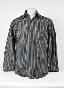
Uniform - Shirt, Country Road, c.2000
Australian shirt from the Sydney 2000 Olympic Games unisex casual uniform (option 2). Designed by Country Road.Blue and white tatterstall shirt with 2000 Australian Olympic emblem on right breast pocket. AUSTRALIA SYDNEY 2000fashion, woolmark company country road, sport, the woolmark company 2000 australian olympic display - exhibition (21/12/2001 - 24/05/2002), sydney 2000 olympic games -
 National Wool Museum
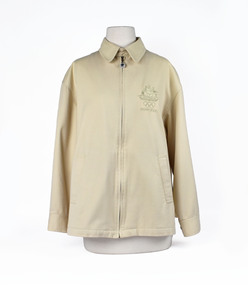
Uniform - Jacket, Country Road, Sydney 2000 Olympic Games Australian Unisex Casual Jacket, c.2000
Australian jacket from the Sydney 2000 Olympic Games unisex casual uniform (option 1). Designed by Country Road.Cream collared jacket with zip. Australian Sydney Olympics emblem embroidered on right breast. SYDNEY 2000fashion, woolmark company country road, sport, the woolmark company 2000 australian olympic display - exhibition (21/12/2001 - 24/05/2002), sydney 2000 olympic games -
 Orbost & District Historical Society
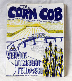
magazines, The Corn Cob, 1976, 1977
These magazines were published fortnightly and distributed to the members of Orbost Apex Club. Apex clubs are volunteer service clubs whose members work in local clubs across urban, regional and rural Australia to raise awareness about social justice issues, assist the needy in a practical way and contribute resources to worthwhile causes.The Orbost Apex Club was a volunteer service club which contributed to the local community. As the population of the area declined so did the number of social clubs.Thirteen magazines which were a fortnightly publication of the Orbost Apex Club. Titled, The Corn Cob, it has a white cover with blue and yellow print. Inside each cover is duplicated material usually two sheets.On front in pen - the number of the issuemagazines orbost-apex corn-cob -
 Orbost & District Historical Society
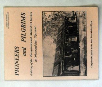
books, Pioneers and Pilgrims, 1986
Rev Peter Gador-Whyte's first UCA Parish was at Orbost in East Gippsland.This is a local history book useful for research and written by a local.Two copies of a 76 pp book titled Pioneers and Pilgrims a history of the Presbyterian and Methodist Churches in Orbost and East Gippsland. The front cover is buff coloured and has a b/w photograph of a group of people standing outside a hut with a bark roof. On the right hand side is a man on a horse. The book was compiled and edited by the Revd Peter Gador-Whyte.2178.2 - Ruth Leggechurch-history presbyterian-methodist-orbost -
 National Wool Museum
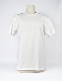
Uniform - T-shirt, Country Road, Sydney 2000 Olympic Games Casual Australian Uniform, c.2000
Australian t-shirt from the Sydney 2000 Olympic Games unisex casual uniform (option 1). Designed by Country Road.White T-Shirt with Australian emblem and Sydney 2000 Olympic logo on left sleeve. AUSTRALIA SYDNEY 2000fashion, woolmark company country road, sport, the woolmark company 2000 australian olympic display - exhibition (21/12/2001 - 24/05/2002), sydney 2000 olympic games -
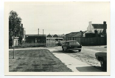 Orbost & District Historical Society
black and white photographs, C 1970s
3288.1 has been taken in Lawson Lane, Orbost, looking west from the rear of the Shire Offices. 3288.2 has been taken in Lawson Lane, Orbost, looking east from the rear of the Shire Offices.These photographs are pictorial records of the Orbost township C 1970s.Two black / white photographs showing cars parked on an unsealed road with buildings in the background.lawson-lane-orbost streets-orbost-1970s -
Whitehorse Historical Society Inc.
Article, Springvale Road tops accident list, 2004
An interview with Ken Ogden of the RACV identifies Springvale Road as the road most likely to have car accidents in Melbourne.An interview with Ken Ogden of the RACV identifies Springvale Road as the road most likely to have car accidents in Melbourne. Included in the worst five corners are those with Whitehorse Road and Canterbury Road.An interview with Ken Ogden of the RACV identifies Springvale Road as the road most likely to have car accidents in Melbourne. road accidents, royal automobile club of victoria, whitehorse road, nunawading, springvale road, nunawading, springvale road, forest hill, canterbury road, forest hill -
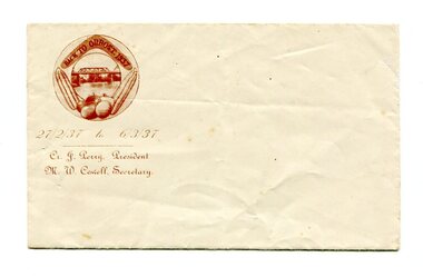 Orbost & District Historical Society
envelope, 1937
This envelope would have been made for the organising committee of the 1937 Back To Orbost celebration.This item was part of of a significant event held in Orbost. A small, white rectangular envelope. In the top left hand corner in dark brown is an illustration of maize, vegetables,a boomerang and the Snowy River Bridge enclosed in an oval frame. Inside the boomerang is "BACK TO ORBOST. 1937". Below is " 27 / 2 /39 to 6 / 3 /3" and below this is "Cr J. Perry President - M.W. Cowell secretary" printed in an ornate text..orbost-back-to-1937 envelope stationery -
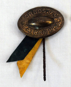 Orbost & District Historical Society
badge
This badge was found underneath a house in Marlo Road. The Orbost football club players were known as the Busters and wore green and gold guernseys. An Orbost football team has participated in the East Gippsland League since the early 20th century. In 2003 in response to a dwindling population, the Snowy Rovers and Orbost Football Clubs were driven to merge into the Orbost Snowy Rovers. Football Club through its many changes has always been an important social fabric of the Orbost community. Sport is often regarded as an important part of life in rural Australia, contributing to community identity, sense of place, social interaction and good healthAn oval shaped metal badge / pin with celluloid ribbons of green and yellow. There is a raised football in the centre.Orbost F.C. Patron 1950 -
Surrey Hills Historical Society Collection
Ephemera, H Bowley, Printer, 192 Canterbury Road, Canterbury, Theatre program - The Arcadians, 17 May 1932, May 1932
William Lock lived at 9 Suffolk Road, Surrey Hills. Donation made at time Libby Cavenagh was Secretary of the Surrey Hills Historical Society.Cream-coloured bi-fold paper program with one corner roughly torn off. [This acted as the admission slip / ticket.] This does not diminish the information. Includes a cast list and synopsis of the three acts."1/1" in lead pencil across the front.camberwell town hall, operetta, the arcadians, wimperis and monckton, surrey hills operatic society, j c williamson, winslow's news agency, entertainment, musical events and activities, miss lilian horn, mr h brett, mr cocking, mr alan abery, mr o danvers, mr foffie, mr j rowse, mrs kennedy, miss u blaikie, miss f callaghan, miss broderick, miss j gordon, mr h denny, mr h collins, mr m latimer, mrs p d clucas, miss i roderick, miss m collins, mr darby, miss phyllis heitsch, miss pearson -
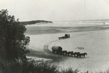 Lakes Entrance Regional Historical Society (operating as Lakes Entrance History Centre & Museum)
Photograph, 1910c
This was a section of the coach road to Orbost in 1858. Also shown are two 2008 colour photographs of the same scene which were used in the before and after photograph 150 years Lakes Entrance 1858 to 2008 display held in 2008Black and white photograph of horse team pulling covered wagon across the bar at Lake Tyers which was a section of the coach road to Orbost at the time Lake Tyers Victoria. animals, transport, roads and streets -
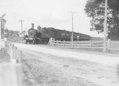 Ringwood and District Historical Society
Photograph, Railway crossing, Bedford Road, Ringwood - c1925, 1925
Steam train at Bedford Road railway crossing, Ringwood. Ferntree Gully line.Written below photograph, "Bedford Road railway crossing - c1925". -
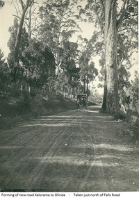 Mt Dandenong & District Historical Society Inc.
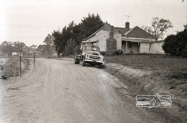
Photograph, Forming Of New Road Kalorama To Olinda, early 1920s
The new Main Road, now Mt Dandenong Tourist Road, was completed in 1926. This scene is looking towards Montrose down from the intesection of Falls Road.Scene of wagon drawn by two horses on wide dirt road with large trees on side of road. Taken just north of Falls Road.wagon, road, main road, mt dandenong tourist road, falls road, horse -
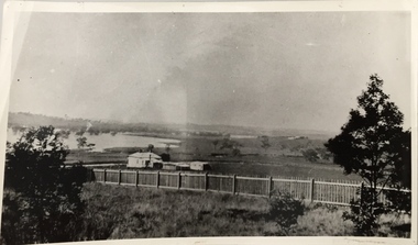 Kew Historical Society Inc
Photograph, Kilby Road, North Kew, 1916
Kilby Road, North Kew 1916. Annotation Reverse: "Kilby Road about 1916. Courtesy Mrs E. Bennett, Kew East."north kew, farming (kew), wade's farm (kew) -
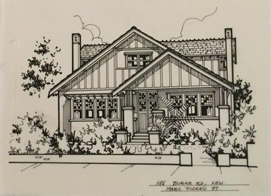 Kew Historical Society Inc
Drawing - Property Illustration, Margaret Picken, 1185 Burke Road, Kew, 1997
After training as a Cartographic Draftsman within the mining industry, I worked as a property illustrator for real estate firms in the eastern suburbs of Melbourne for 23 years from 1983. I initially photographed houses with a Polaroid camera and made a 'thumbnail' sketch while there. The photos were used to scale off a sketch in pencil and then that sketch was overlaid with drafting film and the 'pen and ink' completed. The pens I used were the Rotring ‘Rapidigraph’ drafting pens. The ink was also made by Rotring (German).The film was ‘Rapidraw’, polyester drafting film, double matte. It takes a very fine line and doesn’t bleed. As well as house sketches, there were often floor plans and site plans ordered. Aerial sketches were ordered when the property needed an overall view. (Margaret Picken, 2020)This drawing is one of a series created by Margaret Picken for a range of real estate agents in Melbourne between c.1983 and c.2005. Each work is signed and dated by the artist.Gift of Margaret Picken, 2020Pen and ink architectural drawing on drafting film of 1185 Burke Road, Kew by Margaret Picken.1185 BURKE ROAD., KEW / MARG PICKEN '97artist -- margaret picken 1950-, architectural drawings -- houses -- kew (vic.), 1185 burke road -- kew (vic.) -
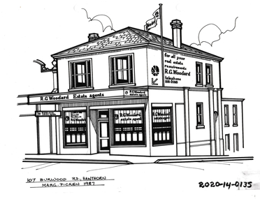 Hawthorn Historical Society
Drawing - Property Illustration, 107 Burwood Road, Hawthorn, 1987
'After training as a Cartographic Draftsman within the mining industry, I worked as a property illustrator for real estate firms in the eastern suburbs of Melbourne for 23 years from 1983. I initially photographed houses with a Polaroid camera and made a 'thumbnail' sketch while there. The photos were used to scale off a sketch in pencil and then that sketch was overlaid with drafting film and the 'pen and ink' completed. The pens I used were the Rotring ‘Rapidigraph’ drafting pens. The ink was also made by Rotring (German).The film was ‘Rapidraw’, polyester drafting film, double matte. It takes a very fine line and doesn’t bleed. As well as house sketches, there were often floor plans and site plans ordered. Aerial sketches were ordered when the property needed an overall view.' (Margaret Picken, 2020)This property illustration is one of a series created by Margaret Picken for a range of real estate agents in Melbourne between c. 1983 and c. 2006. Each work is signed and dated by the artist.Gift of Margaret Picken, 2020Pen and ink property illustration on drafting film of 107 Burwood Road, Hawthorn by Margaret Picken.107 Burwood Road, Hawthorn, Marg Picken '87. artist - margaret picken 1950- -
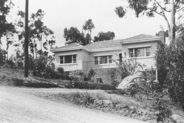 Ringwood and District Historical Society
Photograph, No 12 Glenvale Road, North Ringwood. 1964, 1964
House in Glenvale Road (2 views). See also #2936-2939 for views of Glenvale Road taken at the same time.Written on back of photographs, "1964 - 12 Glenvale Road. Original supplied by Garrett Gundry." (2 views)