Showing 2711 items
matching otway-reef
-
 Tarnagulla History Archive
Photograph: Headframe on rehabilitated Poverty Reef Shaft, Tarnagulla, 1999
Shaft originally sunk in 1859. David Gordon Collection. Colour photograph depicting the headframe on the former Poverty Reef Shaft, Tarnagulla in 1999 after the shaft was rehabilitated by Western Mining Corp for use as a ventilation and safety shaft. mining -
Tarnagulla History Archive
Photograph: Headframe on rehabilitated Poverty Reef Shaft, Tarnagulla, 1999
Shaft originally sunk in 1859. David Gordon Collection. Colour photograph depicting the headframe on the former Poverty Reef Shaft, Tarnagulla in 1999 after the shaft was rehabilitated by Western Mining Corp for use as a ventilation and safety shaft. mining -
 Tarnagulla History Archive
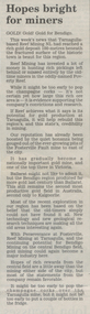
Newspaper clipping: 'Hopes Bright For Miners', 1990s
Donald Clark Collection.A newspaper clipping from the Bendigo Advertiser newspaper, article titled 'Hopes Bright For Miners' about Reef Mining NL finding a rich deposit near Tarnagulla. -
Queenscliffe Maritime Museum
Photograph - Landed Shark
Shark fishing was important to the Queenscliff Point Lonsdale fishing industry since early 1900s. It is still a popular activity in the area today.Fishing of all kind has been an important industry in the Queenscliff region. Although commercial fishing has greatly diminished, recreational fishing is still an important activity.Laminated photograph of a shark on the crane on Fishermans Pier circa 193820 Beach Street Queenscliffe. Debbie O'Hare? [illegible]. Back of Glenuse Reef in Point Lonsdale. Whole salmon for bait 5am. In creek on crane. 2,100Lbs, 8'6" Girthshark, shark fishing, queenscliff, fishing industry -
Lorne Historical Society
Map - Subdivision Map, J Batten Lithos, Plan of West Lorne Loutitt Bay Allotments IV and V
One of the early subdivision maps of Lorne.Black and white printed map on cream paper. The map shows allotments from the Erskine River to the Grand Pacific with an inset of allotments between Smith and Otway Streets. Allotments have the owners names.. The sea baths, Cobb and Co stables , Mountjoys Hotel, the Church of England, the telegraph line to Geelong and the jetty are also marked.lorne, subdivisions, -
Glenelg Shire Council Cultural Collection
Administrative record - House Insurance Policy - Herbert Leslie Vivian, 19/02/1949
Sun Insurance Office Limited Fire Insurance Policy, house and contents, Otway St. Portland. Insured Herbert Leslie Vivian, sum insured: £200.0.0 Premium £-19.10, from 7/3/1949 to 7/3/1950. Printed form. Replacing policy No. F.13994861, due 7/3/1949, for £100.0.0vivian family records, house insurance, otway street portland, herbert l vivian -
 Federation University Historical Collection
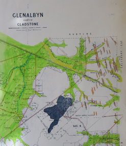
Map, Glenalbyn, County of Gladstone
Copy of a geological map of Glenalbyn. Some areas have been colours green. Creeks have been coloured blue, roads and reefs have been coloured orange.glenalbyn, county of gladstone, tarnagulla, inglewood, kingower, kurting, old inglewood deep lead, salisbury west -
 Bendigo Historical Society Inc.
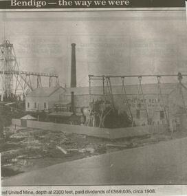
Newspaper - JENNY FOLEY COLLECTION: REEF UNITED MINE
Bendigo Advertiser ''The way we were'' from 2000. Reef United Mine, depth at 2300 feet, paid dividend of 559,035 pound, circa 1908. The clip is in a folder.newspaper, bendigo advertiser, the way we were -
 Bendigo Historical Society Inc.
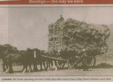
Newspaper - JENNY FOLEY COLLECTION: LOADED
Bendigo Advertiser ''The way we were'' from 2001. Loaded: Bill Childs (standing) and Ken Childs (top) with a load of hay at May Reef in Elmore; circa 1940.newspaper, bendigo advertiser, the way we were -
 Bendigo Historical Society Inc.
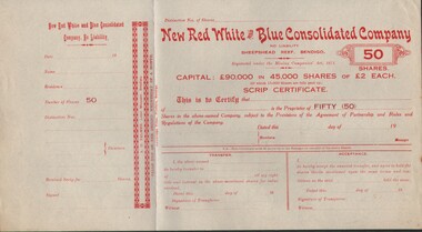
Document - CURNOW COLLECTION: SCRIP CERTIFICATE NEW RED WHITE AND BLUE CONSOLIDATED COMPANY, 19??
Scrip Certificate3 for 50 shares for the 'New Red White & Blue Consolidated Company' - No Liability; Sheepshead Reef, Bendigo. A blank certificate with attached butt. Printer: Cambridge Press.person, individual, curnow collection -
 Bendigo Historical Society Inc.
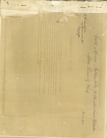
Book - GOLD MINES, GOLDEN PIKE TO THE NORTHERN BLOCKS, MOON LINE OF REEF, April 1906
GOLD MINES, GOLDEN PIKE TO THE NORTHERN BLOCKS, MOON LINE OF REEF. Collection of photos and supporting documentation. Signed on front cover, A. Richardson, 29 Harrison Street, Bendigo.bendigo, gold mining, moon line of reef, bendigo, gold mines, gold mining, moon line of reef. -
 Bendigo Historical Society Inc.
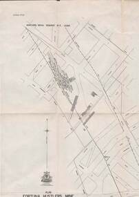
Map - STRUGNELL COLLECTION: HUSTLER'S LINE OF REEFS, BENDIGO, September 1913
Map, Hustler's Line of Reefs, Bendigo, Plan Fortuna Hustler's Mine, Hustler's Royal Reserve No. 2 Lease. Plate No.1(1) Bulletin No 33 Signed H.A.Whitelaw.Underground Survey Office, Bendigo.map, bendigo, fortuna hustler's mine -
 Bendigo Historical Society Inc.
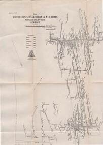
Map - STRUGNELL COLLECTION: UNITED HUSTLER'S & REDAN & K.K.MINES, September 1913
Map, Hustler's Line of Reefs, United Hustler's & Redan & K.K.Mines, Bendigo. Plate No. XXV111 (28),Bulletin 33.Signed H.A.Whitelaw. Drawing seems with their respective mineral contentsUnderground Survey Officemap, bendigo, united hustler's, redan, k.k.mines -
 Bendigo Historical Society Inc.
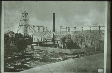
Slide - ALBERT RICHARDSON COLLECTION: CATHERINE REEF UNITED EAGLEHAWK
Slide. Catherine Reef United Gold Mine, Eaglehawk. On LH side, poppet head with elevated tramway . Chimney stack in centre, mine buildings and large shed in background.No. 15 on bottom of slidemine, gold, catherine reef mine., bendigo mines-jack hattam collection -
 Bendigo Historical Society Inc.
Document - MCCOLL, RANKIN AND STANISTREET COLLECTION: NEW DEBORAH REEF GOLD MINE NL - AGREEMENT, 1932
Document: Agreement between New Deborah Reef Gold Mining Company NL and James McKay & Co., including Angus Mackay, T.E. Wilson, and H.J. Leed, directors.organization, mining, new deborah reef gold mine nl, mccoll, rankin and stanistreet: deborah gold mine nl, goldmining, agreement -
 Bendigo Historical Society Inc.
Document - MCCOLL, RANKIN AND STANISTREET COLLECTION: NELL GWYNNE REEF MINE - EXPENSES, 29/8/1935 - 5/10/1938
Document. Book of utility & wage expenses. Nell Gwynne Reef. Dark green cardboard cover with wavy pattern and red binding. Scallop pattern along the edge of the binding.McColl, Rankin & Stanistreetorganization, business, nell gwynne reef mine, mccoll, rankin & stanistreet, nell gwynne reef mine, gold mining, expenses -
 Anglesea and District Historical Society
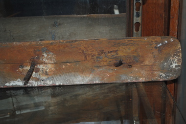
Ship Railing, 1895
"Inverlochy" wrecked 1902.Part of the railing from the "Inverlochy" which wrecked in 1902 on the "Ingoldsby" reef, Anglesea River, 1902. Includes three nails protruding at right angles from the wooden piece.inverlochy, ship railing -
Tarnagulla History Archive
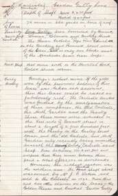
Letter and article, Old Tarnagulla-ites, 1st July, 1965
Donald Clark Collection.A typed letter from the Old Tarnagulla-ites Society to one of its members, and an article about Tarnagulla history 'The Riches Of Poverty Reef') which was enclosed with and is discussed in the letter. -
 Tarnagulla History Archive
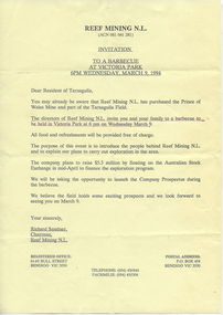
Invitation: Reef Mining NL BBQ, 1994
Donald Clark Collection.An invitation to the residents of Tarnagulla from Reef Mining NL for a BBQ to be held in Victoria Park to announce details of the company's proposed mining activities. Held on March 9, 1994. -
 Federation University Historical Collection
Map, Ballaarat Gold Field, 1861, 1861
A party of surveyors camped by Yuille's Swamp (later Lake Wendouree) and surveyed the countryside for a map to be produced by the Geological Survey of Victoria. In November 2004 the Central Highlands Regional Library presented a special edition of 200 copies of the 1861 map reproduced from a copy in their collection. Original 1861 map of Ballarat showing streets and leads. Blue dots indicate gold leads, and red lines indicate auriferous quartz reef and outcrops of quartz veins."Compiled & Drawn from the Survey of Mining Surveyors Davidson, Fitzpatrick and Cowan & the Plans in the Surveyor General's Office by J. Brahe, 21st October 1861. R. Brough Smyth, Secretary for Mines. The Honourable J.B. Humffray, M.L.A. Commr of Mines.”ballarat, map, ballarat east, lake wendouree, survey, mines, robert davidson, ballarat gold field 1861, yuille's swamp, wendouree swamp, little bendigo diggings, gold leads, old post office hill, specimen hill, bakery hill, black hill, dead horse creek, brown hill, pennyweight hill, clayton hill, soldiers hill, golden point, gum tree flat, white flat, poverty hill, chinese village, robert brough smyth, ballarat map 1861, ballaarat vineyard, dead horse gully, deadhorse creek, invermay, black hill flat, gaelic church, police reserve, magpie range, dalton's flat, caadian lead, rifle butts, powder magazine, bathing house, government camp, gold office, chinese, llanberrris, victoria theatre, charlie napier hotel, united states hotel, grape's hoel, clayton's hill, cattleyard hill, free trade hotel, esmond lead, bakery hill, black hill lead, juvenile reformatory, ballarat orphanage, lady barkly lead, triffet's slaughter yard, little bendigo, melbourne road, t. cowan, thomas cowan -
Stawell Historical Society Inc
Map, Township of Stawell
B/W map of Stawell Surveyed by Easton Johnston Contract surveyor Scale in Chains. Showing Special Allotments Reefs, Pleasant Creek Parish of Stawell. Map No L4000 -
 Bendigo Historical Society Inc.
Document - CARLISLE UNITED MINE GARDEN GULLY LINE
4 hand written foolscap pages of information about the Carlisle United Mine. Information such as area of lease, depth, locality, early history, plant & equipment, gold obtained and dividends. Also some information on the Kent Shaft. The Carlisle United was formed by the amalgamation of three companies, the Old Carlisle, the North Garden and the Passby. Also mentioned are: the Golden Fleece, Central Garden Gully, Garden Gully United and its Tribute Companies, the Constellation, Specimen Hill Mine, Kocks Pioneer, Bendigo Amalgamated Mines, the Pandora Reef, the Unity Reef, Guilford Plateau and the Nell Gwynne Reefs Mine. Also 2 typed copies of notes on foolscap paper.place, mining site, carlisle united mine, carlisle united mine, kent shaft, old carlisle, north garden, passby, mr j b watson, golden fleece, central garden gully, garden gully united, tribute companies, constellation, bendigo amalgamated mines, specimen hill mine, kocks pioneer, pandora reef, unity reef, guilford plateau, nell gwynne reefs mine -
Bendigo Historical Society Inc.
Document - MINING WARDEN COLLECTION: BENDIGO HISTORICAL MINING RECORDS
Historical records originally from the Mining Warden's Office, Mines Department, Bendigo. Information collated from 1870's to 1980's. A summary document lists the BEN# from 3754 to 4080 and describes the mine name; the BEN#, the line of reef located on, the start and end year. Individual mine data is enclosed in a manilla folder within the box. Reef lines listed are: Derby Christmas Garden Gully Gravel Hill Thistle Carshalton Myers Flat Birds Hit or Miss Break of Day Crusoe Big Hill line Sample entry: Brilliant Co., BEN# 3757, Garden Gully line of reef, 1870 - 1880.bendigo, mining, mining warden records -
 Warrnambool and District Historical Society Inc.
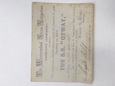
Ticket, The Warrnambool Steam Navigation Co Ltd, 1873
This card relates to an excursion aboard “The SS Otway leaving the Warrnambool Jetty at 8 am April 18th 1873 to go to Belfast and Portland courtesy of the Warrnambool Steam Navigation Company Limited which was originally called the Warrnambool Steam Packet Company. The Otway was the second steamer purchased by the company. It had a number of ships which traded along the coast including, the Nelson, Julia Percy, Otway and The Edina. The Edina was originally owned by Stephen Henty who was operating it from Portland but he sold it to the new company for £8500. Henty then withdrew from the Belfast and Warrnambool trade for a time but it proved to be a competitive business. The name was changed again in 1878 to The Western Steam Navigation Company and the SS Otway was put up for sale. This card relates to one of the first trips, if not the first trip, taken by the SS Otway Shipping was a major part of the history of Warrnambool and this ticket is a link to one of the earliest passenger and freight services which operated along the coast.Small cream card with light purple text with company name at the top. Capital letters done in scroll lettering. There are feint markings in the centre of the back which appear to have been rubbed off.Signed by Captn Selby. William R Evans manager. 18th April 1873.warrnambool steam navigation company, edina, stephen henty, s s otway -
 Glenelg Shire Council Cultural Collection
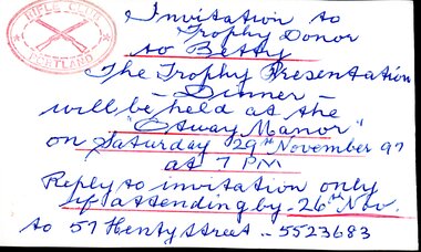
Document - Invitation - Portland Rifle Club Presentation Night, Nov-97
Invitation to Betty Vivian, as a trophy donor at the Rifle Club trophy presentation night. Handwritten on white card in blue ink, red rifle club stamp, top left.Invitation to / Trophy Donor / To Betty / The Trophy Presentation / -Dinner- / will be held at the / 'Otway Manor' / on Saturday 29th November 97 / at 7pm / Reply to invitation only / if attending by -26th Nov. / to 57 Henty Street - 5523683portland rifle club, vivian family records, invitation, invite, betty vivian collection -
Federation University Historical Collection
Map, Otways Walks and Waterfalls Map, 2013, 06/2013
Tourist map of the Otways showing the townships of Colac, Lorne, Apollo Bay, Beech Forest, Forrest, Barwon Downs, Deans March, Winchelsea, Gellibrand, Lavers Hill, POrt Campbel, Princetown, Johanna, Timboon, Cobden, Camperdown, Swan Marsh, Simpson, Birregurra, Beeac, Marengo, Wye River, Kennett River, Skenes Creek, Peterboroughcolac, lorne, apollo bay, beech forest, forrest, barwon downs, deans march, winchelsea, gellibrand, lavers hill, port campbel, princetown, johanna, timboon, cobden, camperdown, swan marsh, simpson, birregurra, beeac, marengo, wye river, kennett river, skenes creek, peterborough< marriners falls, beauchamp falls, hopetoun falls, triplet falls, little aire falls, stevensons falls -
Bendigo Historical Society Inc.
Map - HUSTLER'S REEF NO 1 MINE - EAST & WEST CROSS-CUTS OF THE HUSTLER'S REEF NO 1 MINE
Map showing the East & West Cross-cuts, North & South of Shaft of the Hustler's Reef No 1 Mine on the Hustler's Line of Reefs Bulletin No 33, Plate No XXII. Drawing shows where the different levels are, the stone encountered and smaller drawings of other sections near the shaft. Also shows some geographical features. Signed by H A Whitelaw, Underground Survey Office Bendigo, September, 1913. Geological Survey of Victoria emblem .mining, parish map, hustler's reef no 1 mine, east & west cross-cuts of the hustler's reef no 1 mine, geological survey of victoria, h a whitelaw, underground survey office bendigo, hustler's line of reefs -
 Bendigo Historical Society Inc.
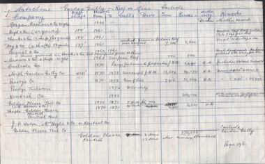
Document - CARLISLE MINE - GOLD PRODUCTION
2 hand written sheets of paper, titled Anticline Garden Gully - Reef or Mine Carlisle. Has the name of companies, depth of shaft, years, calls, Divs, Tons, Ounces, Authority & Remarks. Dates from 1860 to 1918. Reference: Production Statistics Bendigo Mines N. L. Bendigo Goldfields, History & Production. General Index. Companies & Reefs. Pages 196 & 197. Mines Dept. Bendigo Office.mine, gold, carlisle, carlisle mine, gold production, mines dept. bendigo -
Bendigo Historical Society Inc.
Document - NEW CHUM & VICTORIA LINES OF REEF - NOTES ON JOHNSON'S REEF
Handwritten notes mention 'History of Bendigo by G Mackay, St Mungo Line of Reef from the Belmont Mine, Princess Alexander Shaft, Johnson's no 1 Mine, North Johnson's with notes on buildings, etc and date 22/9/1892, and the Johnson's Reef Extended dated 29/10/1892, with note on building, mullock heap, and sill 779.18 above sea level. Also mentioned are Leo Chapman and Tom Sayers.document, gold, new chum & victoria lines of reef, new chum & victoria lines of reef, notes on johnson's reef, history of bendigo, g mackay, mines' dept, st mungo line of reef, e j dunn report 21/10/92, princess alexander shaft, united devonshire shaft, johnson's reef, garden gully line, johnson's no 1 mine, north johnson's, e j dunn's report 29/10/1892, johnson's reef extended, leo chapman, tom sayers -
 Bendigo Historical Society Inc.
Document - ALBERT RICHARDSON COLLECTION: NORTH JOHNSON'S MINE, GARDEN GULLY REEF
Two page typed document detailing information of the North Johnson's Mine on the Garden Gully line of reef. The mine was located in California Gully, the shaft is approximately 66 yards north of Thomas Street. The shaft was 3,480 ft deep and sunk with the line of reef. This company, together with its northern neighbour the Rose of Denmark, first became a prominent gold producer in 1867. For its size, one of the richest mines in Bendigo.bendigo, mining, north johnsons mine