Showing 8789 items
matching south road
-
 Glenelg Shire Council Cultural Collection
Photograph - Photograph - Portland Bay, n.d
... going beneath Cape Nelson bridge. House on south side of ring... on south side of ring road, Portland on north side of Lagoon ...Port of Portland Authority ArchivesBack: - B.P & shed 5. in pencilport of portland archives, fawthrop lagoon -
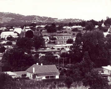 Clunes Museum
photograph, 1967
... 1967. PHOTOGRAPH TAKEN FROM SCENIC ROAD FACING SOUTH, BUILDINGS... SCENIC ROAD FACING SOUTH, BUILDINGS INCLUDE POST OFFICE ...BLACK AND WHITE PHOTOGRAPH OF CLUNES TOWNSHIP TAKEN CIRCA 1967. PHOTOGRAPH TAKEN FROM SCENIC ROAD FACING SOUTH, BUILDINGS INCLUDE POST OFFICE, METHODIST CHURCH, ST. THOMAS PRESBYTERY ETC.local history, photography, photographs, clunes township -
Whitehorse Historical Society Inc.
Document, Forest Hill Police Complex Opening, 6/04/2016 12:00:00 AM
... Hill Police Complex on 6 Apr 2016 at 469 Springvale Road... Road Vermont South No. 469 The Program of the Official Opening ...The Program of the Official Opening Ceremony of the Forest Hill Police Complex on 6 Apr 2016 at 469 Springvale Road, Vermont South.The Program of the Official Opening Ceremony of the Forest Hill Police Complex on 6 Apr 2016 at 469 Springvale Road, Vermont South, attended by Vicki Jones-Evans and Rachael Cottle of the Whitehorse Historical Society.The Program of the Official Opening Ceremony of the Forest Hill Police Complex on 6 Apr 2016 at 469 Springvale Road, Vermont South. forest hill police complex, springvale road, vermont south no. 469 -
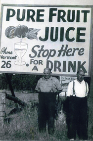 Whitehorse Historical Society Inc.
Photograph, Doncaster Fruit Juices and Syrups
... and Morak Road, Vermont South.... located on corner of Burwood Highway and Morak Road, Vermont South ...See NP4086Black and white photograph of Paul(left) and William Pietsch in front of a sign encouraging people to stop and have a drink of pure fruit juices located on corner of Burwood Highway and Morak Road, Vermont South.pietsch, william, paul, doncaster fruit juices, doncaster fruit juices and syrups -
Glen Eira Historical Society
Article - Langi, Kooyong Road, 334, Caulfield South
... Langi, Kooyong Road, 334, Caulfield South... Kooyong Road South Caulfield from Property Review Weekly dated...334 Kooyong Road, Caulfield South, Victoria, Australia... located 334 Kooyong Road South Caulfield from Property Review ...Article with Photographs on Langi Property located 334 Kooyong Road South Caulfield from Property Review Weekly dated March 5, 2004. Six photographs of exterior and interior façade of the property. Seven colour photographs depicting kitchen, hallway and gardens.langi, kooyong road, caulfield south, talbot birner morley -
 Glen Eira Historical Society
Photograph - Hawthorn Road, 464, Caulfield South
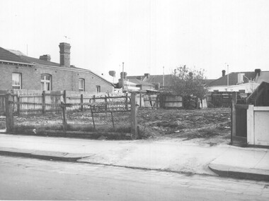
... Hawthorn Road, 464, Caulfield South...9 digital photographs of a group of houses in Hawthorn Road...464 Hawthorn Road, Caulfield South, Victoria, Australia... in Hawthorn Road Caulfield South that are about to be demolished ...9 digital photographs of a group of houses in Hawthorn Road Caulfield South that are about to be demolished for a new property development Photographer Claire Barton 30/07/2010hawthorn road, caulfield south, houses -
Canterbury History Group
Photograph - 122 and 120 Maling Road, Canterbury in 1993, Jan Pigot, 1993
... shops on the south side of Maling Road. Both shops have been... Restoration shops on the south side of Maling Road. Both shops have ...Coloured photograph of Farren-Price and Antique Restoration shops on the south side of Maling Road. Both shops have been occupied since 1923 by varied businesses. No. 122 was the Commerical Bank from 1929-1942.canterbury, maling road, antique shops, gift shops, palm trees, hel> f and j, farren-price, canterbury mansions, banks, signs, streetscapes -
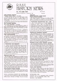 Bendigo Historical Society Inc.
Magazine - R.H.S.V. HISTORY NEWS. NO. 78 JUNE 1987
... of Victoria Inc. 1 City Road, South Melbourne 3205. George Whithurst... City Road, South Melbourne 3205. George Whithurst-Richmond ...Three copies of the Royal Historical Society of Victoria's 'R.H.S.V History News. No. 78 June 1987.' Royal Historical Society of Victoria Inc. 1 City Road, South Melbourne 3205. George Whithurst-Richmond Chronicle, Shakespeare Place, Richmond, 3121. 6 pgs. Subscription 1987-88 applications.victoria, history, people and places in victoria., royal historical society of victoria, history, victorian history, magazines, history news, australian history, australia, victoria -
Tatura Irrigation & Wartime Camps Museum
Photograph - copy, House built by John Sebastian Smith
... of Merrigum on Andrews Road, south side. The house was built by John..., 6 kms. west of Merrigum on Andrews Road, south side ...Weatherboard house, shingle roof, former hotel, 6 kms. west of Merrigum on Andrews Road, south side. The house was built by John Sebastian Smith who built the first hotel in Merrigum, and occupied by Thomas Alcorn from 1911 until 1967. Demolished in 1982.Photocopied photo and letter of explanation. -
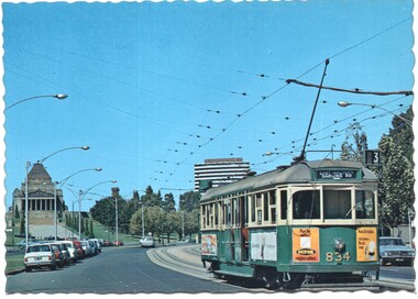 Melbourne Tram Museum
Postcard - Nu-color-Vue - St Kilda Road, Shrine of Remembrance W5 834, Nucolorvue Publishing, 1970s
... Postcard - image looking south in St Kilda Road... Postcard - image looking south in St Kilda Road, with the Shrine ...Postcard - image looking south in St Kilda Road, with the Shrine of Remembrance and BP House in the view. Tram W5 834 (East Malvern Darling Road Route 3).Demonstrates an iconic Melbourne image, St Kilda Road, the Shrine and a W class tram.Postcard colour - serrated edge, Nu-color-Vue - St Kilda Road, Shrine of RemembranceW5 834, ML 132,, Divided back.trams, tramways, shrine of remembrance, st kilda road, sw5 class tram, tram 834 -
 Bendigo Historical Society Inc.
Photograph - COLIBAN MAIN CHANNEL, July,2009
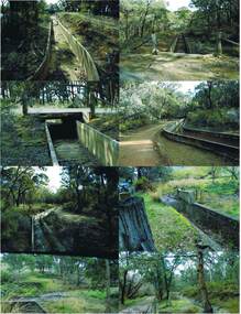
... Main Channel. Photo's 1,2,3,4 + 5 = were taken from South... 1,2,3,4 + 5 = were taken from South Mandurang Road, Spring Road ...Photograph - colour. All photographs are of the Coliban Main Channel. Photo's 1,2,3,4 + 5 = were taken from South Mandurang Road, Spring Road end. Photo's 6,7,8,9,10,11,12 + 13 = were taken top of dirt road section of Springs Road. Photo's 14 + 15 = Taken between Sedgwick and North Harcourt, used to be called 'Prestonvale'. Photo No.14 is called Wirths Tunnel, 633 metres in length. Three more sheets of photo's of the Coliban Main Channel, between Sedgwick and Harcourt North. If more info.Ray Smith and Phil Wilkin - Bendigo Historical Society.place, water, coliban race, coliban main channel. -
Kew Historical Society Inc
Archive (Sub-series) - Subject File, Conservation Study (Kew) 1978, 1978
... Street, High Street South and Barkers Road, then known... in Denmark Street, High Street South and Barkers Road, then known ...Various partiesReference, Research, InformationSecondary Values (KHS Imposed Order)Subject file containing a copy of the City of Kew’s Urban Renewal Proposal (13pp), dated June 1978. The proposal to the Urban Renewal Authority relates to those houses in Denmark Street, High Street South and Barkers Road, then known as ‘The Triangle’ (historically known as O’Shaughnessy’s Paddock. The report refers to the Kew Triangle Association.urban renewal -- kew (vic.), conservation studies -- kew (vic.), kew triangle associationurban renewal -- kew (vic.), conservation studies -- kew (vic.), kew triangle association -
Whitehorse Historical Society Inc.
Article, Hobby became a Career in Time, 2000
... on 22 Sept 2000. Born 7 Feb 1910, he moved to Holland Road... Mitcham melbourne LaGalle Ted Holland Road Blackburn South Forest ...Obituary for Blackburn Watchmaker, Ted LaGalle, who died on 22 Sept 2000. Born 7 Feb 1910, he moved to Holland Road, Blackburn South, aged 10, where parents ran a poultry farm.lagalle, ted, holland road, blackburn south, forest hill secondary college blackburn south campus, lagalle, nick, lagalle, florence, lagalle marjorie, lagalle, edna, higham, t.j., lagalle, rita, lagalle, keith, box hill salvation army band, poultry farms -
 Whitehorse Historical Society Inc.
Photograph, Heatherdale Reserve, 2000
... between Purches Street and Heatherdale Road to south of Panel...Whitehorse Historical Society Inc. 2-10 Deep Creek Road ...Produced as one of a series of 24 prints commissioned by Nunawading & District Historical Society -|Theme: Intersections of Mitcham and Nunawading 2000/2001.|See also Series by P. Simmenauer on the same theme.Black and white photograph - print and negative of Heatherdale Reserve - Whitehorse side of Heatherdale Road - Features view of Heatherdale Bowls Club with flower garden. Located between Purches Street and Heatherdale Road to south of Panel street.heatherdale bowls club, heatherdale road vermont, heatherdale reserve -
 Eltham District Historical Society Inc
Negative - Photograph, J.A. McDonald, One Tree Hill Road Bridge, Christmas Hills, 2 July 1962
... One Tree Hill Road Looking south 2/7/62 The bridge... melbourne One Tree Hill Road Looking south 2/7/62 The bridge ...One Tree Hill Road Looking south 2/7/62 The bridge was destroyed by bushfires 15-16 January 1962. A temporary bridge was set up to the east sideRecord of various Shire of Eltham infrastructure works undertaken during the period of 1952-1962 involving bridge and road reconstruction projects, sometimes with Eltham Shire Council Project Reference numbers quoted. It was during this period that a number of significant improvements were made to roads and new bridges constructed within the shire that remain in place as of present day (2022). In many situations, the photos provide a tangible visible record of infrastructure that existed throughout the early days of the Shire. The album was put together by or under the direction of the Shire Engineer, J.A. McDonald.1962-07-02, bridge construction, christmas hills, infrastructure, shire of eltham, victorian bushfires - 1962, bush fires, one tree hill road, property damage -
 St Kilda Historical Society
Photograph, c. 1973
... Kilda Road. The shops and houses on the south side of the road... on the south side of the road were demolished to allow ...High Street St Kilda was widened in 1973 and renamed St Kilda Road. The shops and houses on the south side of the road were demolished to allow for the construction of a multiple lane highway.colour photographst kilda, high street, -
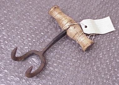 National Wool Museum
Bale Hook
... Found by RC and J Lewis in laneway running south from...-and-the-bellarine-peninsula Found by RC and J Lewis in laneway running south ...Found by RC and J Lewis in laneway running south from Western Beach Road between Dalgety North building and Dennys Lachelles building (old Corio Tannery site). -
 Eltham District Historical Society Inc
Photograph - Aerial Photograph, Landata, Research, Vic, Feb. 1956
... to south, Bells Hill Road to east and Eucalyptus Road to west... to south, Bells Hill Road to east and Eucalyptus Road to west ...Centred on present day Thompson Crescent, Research bounded by Maroondah Aqueduct to north, Thompson Crescent and Nyora Road to south, Bells Hill Road to east and Eucalyptus Road to west Historic Aerial Imagery Source: Landata.vic.gov.au Aerial Photo Details: Project No :250 Project : MELBOURNE OUTER SUBURBS PROJECT Run : 19 Frame : 6 Date : 02/1956 Film Type : B/W Camera : EAG9 Flying Height : 10000 Scale : 12000 Film Number : 1176 GDA2020 : 37°42'38"S, 145°11'02"E MGA2020 : 339927, 5824736 (55) Melways : 22 H4 (ed. 42)aerial photo, 1956-02, neil webster collection, bells hill road, eltham, eucalyptus road, maroondah aqueduct, melway 22h4, nyora road, research (vic.), thompson crescent -
Glen Eira Historical Society
Letter - Hawthorn Road, 566, Caulfield
... Road, South Caulfield. Current address is 566 Hawthorn Road... Road and North Road, South Caulfield. Current address is 566 ...Three paged letter dated 18/08/1980 from Food Plus Stores to City of Caulfield giving support factors re proposed redevelopment for a Food Plus Store corner of Hawthorn Road and North Road, South Caulfield. Current address is 566 Hawthorn Road, Caulfield.hawthorn road, caulfield, food stores plus, city of caulfield, petrol stations, shops, employment, commercial establishments -
 Melbourne Tram Museum
Photograph - Set of 12 Black & White Photograph/s, Melbourne & Metropolitan Tramways Board (MMTB), 1966
... St and Punt Road, South Yarra. Shows the vacant block... St and Punt Road, South Yarra. Shows the vacant block ...Series of 12 black and white photographs of the construction of a new substation, during 1966 at the corner of Greville St and Punt Road, South Yarra. Shows the vacant block, construction of the foundations, walls and a part of the roof. In the box was a slip of paper marked - "To Architect 6.6.66" See item 7269 for three colour photographs of the completed building.On the rear of some of the photos are dates eg 30/5 on .1 trams, tramways, substation, electrical equipment, electrical switching, buildings -
 City of Moorabbin Historical Society (Operating the Box Cottage Museum)
Document, laminated photocopy of 'Plan of Moorabbin 1850', 1853
... North Road to South Road in the Parish of Bourke Victoria... Phillip Bay to East Boundary Road and from North Road to South ...Weston Bate, 'A history of Brighton' 1962 informs us that in 1840 Henry Dendy, who was a farmer in Sussex England, paid 5,120 pounds sterling @ 1pound per acre for a 'Special Survey of Land in Port Phillip , Australia. Henry arrived in Australia in 1841 on the frigate 'York' with his wife, son, and three servants. He also took advantage of the Government Assistance of Free Immigrants for Survey Purchasers, to help on his estate and persuaded some Sussex men with their families to follow him. However when Dendy arrived in Port Phillip he found that LaTrobe and Gipps were trying to raise the price of land close to Town to 15pounds per acre. Dendy asked merchant J.B.Were to manage his affairs and they went ahead with plans to subdivide the surveyed land called 'The Brighton Estate' This area of land extended easterly from the Port Phillip Bay to East Boundary Road and from North Road to South Road in the Parish of Bourke Victoria. The Privy Council, England , decide that Henry Dendy could purchase the land at 1pound per acre. Land Sales proceeded from 1844 as more immigrants established market gardens, farms and varied businesses in 'Moorabbin'This is a photocopy of a Map of the Moorabbin , County of Bourke c1850 showing the 'Henry Dendy Special Survey 1841'A photocopy of a Map of the Moorabbin , County of Bourke c1850. A3 size laminatedLeft corner : MOORABBIN / COUNTY OF / BOURKEdendy henry, dendy special survey 1841, brighton, moorabbin, ormond, bentleigh, market gardeners, pioneers early settlers, box william, box elizabeth -
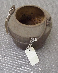 National Wool Museum
Pot, smelting
... south from Western Beach Road between Dalgety North building... running south from Western Beach Road between Dalgety North ...Found by Roger Cummings and J Lewis in laneway running south from Western Beach Road between Dalgety North building and Dennys Lachelles building (old Corio Tannery site). -
National Wool Museum
Pot, smelting
... south from Western Beach Road between Dalgety North building... running south from Western Beach Road between Dalgety North ...Found by Roger Cummings and J Lewis in laneway running south from Western Beach Road between Dalgety North building and Dennys Lachelles building (old Corio Tannery site). -
 Whitehorse Historical Society Inc.
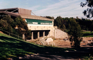
Photograph, Waste Transfer Station
... and opposite Mahoneys Road Vermont South. Land fill was used until... Creek and opposite Mahoneys Road Vermont South. Land fill ...The waste centre is situated next to Dandenong Creek and opposite Mahoneys Road Vermont South. Land fill was used until the 1980's when Whitehorse joined the "least Waste" program.Coloured photograph of the City of Whitehorse Recycling & Waste Centre, rear view. Situated in Vermont South near Dandenong Creekwaste transfer station, whitehorse transfer station, waste, recycling -
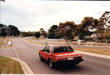 Hume City Civic Collection
Photograph, Late 1990's
... is on the south side of the road.... is on the south side of the road. Photograph ...Riddell Road is the continuation of Macedon Street and is on the west side of the town centre. It is the main road to Riddells Creek, the Sunbury airstrip, Sunbury tip and water towers.A coloured photograph of Riddell Road looking west. A red car is in the foreground travelling north and is at the T intersection of Riddell Road and Ligar Street. There are houses along the north side of Riddell Road and the football ground is on the south side of the road.sunbury football club, riddell road, ligar street, george evans collection -
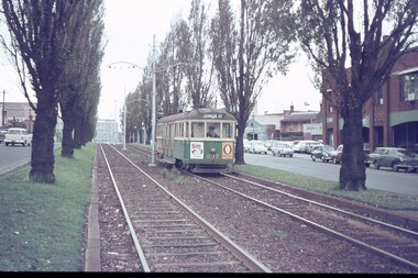 Melbourne Tram Museum
Slide, Keith Caldwell, Apr. 1964
... by Keith Caldwell of W5 809 in Peel St North Melbourne, south... Melbourne, south bound to Domain Road, route 56. Has an advert ...Agfa colour slide, blue / white plastic mount, photo by Keith Caldwell of W5 809 in Peel St North Melbourne, south bound to Domain Road, route 56. Has an advert for Bisto gravy. 4/1964In ink "Peel St 4-64"trams, tramways, w5 class, peel st, domain rd, route 56, tram 809 -
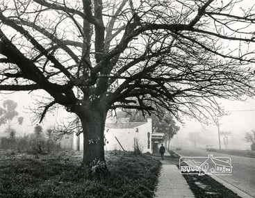 Eltham District Historical Society Inc
Photograph, Old Oak Tree near cnr of Franklin Street and Main Road, Eltham
... Black and white photograph looking south down Main Road... Black and white photograph looking south down Main Road at a fog ...Black and white photograph looking south down Main Road at a fog-shrouded view of an old large oak tree which still stands at the entrance to the Eltham Hotel car park. Antiques store in centre now Cafe Zen Den (2017) and across the road is the Mobil Service Station, now a commercial business centrepioneers and painters, main road, franklin street, eltham -
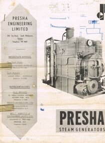 Bendigo Historical Society Inc.
Document - BROCHURE: PRESHA STEAM GENERATORS
... , 290 City Road, South Melbourne, Victoria. Photo of large... Presha Engineering Limited brochure, 290 City Road, South ...Grey and white 2 page Presha Engineering Limited brochure, 290 City Road, South Melbourne, Victoria. Photo of large square shaped steam generator on front cover, written in pencil top centre ' Length 14.9'; width 6'10', height 11'3', 100 hp. Specifications written in centre pages and back page.organisation, commerce, presha steam generators -
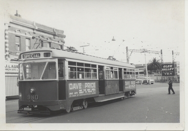 Melbourne Tram Museum
Photograph - Black & White Photograph/s, Chris Phillips, Feb. 1969
... Price advertisement on the side of the tram. ARE Tour ex South... of the tram. ARE Tour ex South Melbourne depot. Road name ...Black and white photograph of PCC 980 at Caulfield Station area, during a special tram tour, 9/2/1969. Photo by Chris Phillips. Glen Valley Tea advert in background. Has a Dave Price advertisement on the side of the tram. ARE Tour ex South Melbourne depot. Road name to be advised. Printed on Kodak Paper.In red ink "PCC 980 Caulfield Stn 9/2/69"trams, tramways, mmtb, special trams, caulfield, tram 980, pcc class -
 Eltham District Historical Society Inc
Photograph - Aerial Photograph, Landata, Eltham, Vic, Feb. 1956
... , Thompson Crescent and Norman Road to south, Bells Hill Road to east..., Thompson Crescent and Norman Road to south, Bells Hill Road to east ...Centred on present day Parsons Avenue at Leane Drive near the Maroondah Aqueduct, Eltham bounded by Lorimer Road to north, Thompson Crescent and Norman Road to south, Bells Hill Road to east and Parsons Road to west Historic Aerial Imagery Source: Landata.vic.gov.au Aerial Photo Details: Project No :250 Project : MELBOURNE OUTER SUBURBS PROJECT Run : 19 Frame : 5 Date : 02/1956 Film Type : B/W Camera : EAG9 Flying Height : 10000 Scale : 12000 Film Number : 1176 GDA2020 : 37°42'04"S, 145°11'09"E MGA2020 : 340064, 5825786 (55) Melways : 22 H1 (ed. 42)aerial photo, 1956-02, neil webster collection, allendale road, bells hill road, eltham, leane drive, lorimer road, maroondah aqueduct, melway 22h1, norman road, parsons road, research (vic.), thompson crescent