Showing 634 items
matching town development
-
 Wodonga & District Historical Society Inc
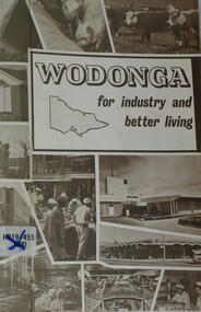
Booklet - Wodonga For Industry and Better Living, Wodonga Development Committee, c1960 - 1970
This publication was produced to promote the benefits of Wodonga for lifestyle and decentralised industry. In 1973 the Commonwealth, New South Wales and Victorian Governments agreed to the Albury-Wodonga Development Scheme, for a decentralised growth area. Before then the Wodonga Development Committee and the Shire Council promoted the town’s industrialisation. This booklet was published to encourage new investment in the Wodonga area prior to the convening of the Albury-Wodonga Development Scheme.A small booklet of 18 pages printed in black and white, including photos and promotional material about Wodonga and District.This publication was produced to promote the benefits of Wodonga for lifestyle and decentralised industry. In 1973 the Commonwealth, New South Wales and Victorian Governments agreed to the Albury-Wodonga Development Scheme, for a decentralised growth area. Before then the Wodonga Development Committee and the Shire Council promoted the town’s industrialisation. This booklet was published to encourage new investment in the Wodonga area prior to the convening of the Albury-Wodonga Development Scheme.wodonga promotions, albury wodonga, wodonga development committee -
 Wodonga & District Historical Society Inc
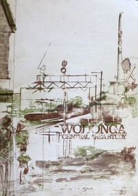
Book - Wodonga Central Area Study, Loder and Bayly, Planning & Engineering Consultants, March 1975
... Wodonga Town planning Albury-Wodonga development Rural City ...This report was the result of an investigation into the potential future development and town planning for the central area of Wodonga. Chapters of the final report are:- Chapter 1: Summary: Conclusions and Recommendations, Chapter 2: Setting the scene, Chapter 3: Possible futures, Chapter 4: Objectives, Chapter 5: Growth Options, Chapter 6: Recommended approaches, Chapter 7: Plan elements and Chapter 8: Ways and Means.A report of 134 pages, including illustrations and maps. The report was presented to the Albury-Wodonga Development Corporation and the Rural City of Wodonga.This report was the result of an investigation into the potential future development and town planning for the central area of Wodonga. Chapters of the final report are:- Chapter 1: Summary: Conclusions and Recommendations, Chapter 2: Setting the scene, Chapter 3: Possible futures, Chapter 4: Objectives, Chapter 5: Growth Options, Chapter 6: Recommended approaches, Chapter 7: Plan elements and Chapter 8: Ways and Means.wodonga town planning, albury-wodonga development, rural city of wodonga -
 Wodonga & District Historical Society Inc
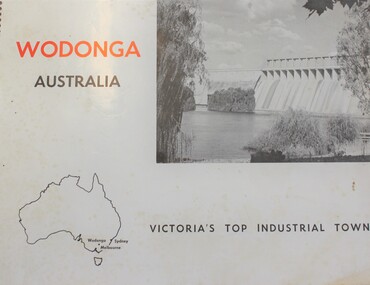
Book - Wodonga Australia - Victoria's Top Industrial Town, Wodonga Promotions Committee, 1966
Winning the top award for "Industrial Development" in the Victorian Premier Town Contest 1964, Wodonga was recognised and declared the chief industrially developing town outside the Melbourne metropolitan area. This publication outlines the key features of Wodonga supplemented with photos and maps.non-fictionWinning the top award for "Industrial Development" in the Victorian Premier Town Contest 1964, Wodonga was recognised and declared the chief industrially developing town outside the Melbourne metropolitan area. This publication outlines the key features of Wodonga supplemented with photos and maps.wodonga description and travel, wodonga development -
 Wodonga & District Historical Society Inc
Map - Boorgunyah - "The Town that never was"
At the height of the river trade, there was a town surveyed and laid out, and streets were named. This town was to house the workers at the river port of Red Bank when the paddle steamers plied the Murray River as far as Albury, carrying produce such as wool and wheat to the various towns along the river in the 1800s. As the river trade died away, this town never went ahead – one might say, “The town that never was.” A lone gum tree stands on the site today.This item is significant because it documents plans which were made for the early development of Wodonga.A black an white map depicting the proposed location of the township. The map is based on a sketch and is not to scale,early wodonga, boorgunyah - "the town that never was", wodonga heritage -
 Wodonga & District Historical Society Inc
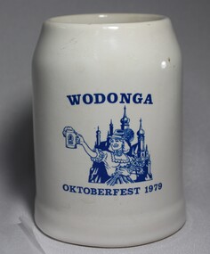
Memorabilia - Wodonga Oktoberfest Stein, c1979
... contributions to the development of the town. In the years 1868-69 more... to the development of the town. In the years 1868-69 more settlers arrived ...Several German families arrived in Wodonga, usually via South Australia, in the late 1850 and 1860s. Some of the earliest settlers to arrive were the Haeusler, Schlink, Trudewind, Pfeiffer and Klinge families. Many of them had left from Prussia and Bavaria to escape religious persecution. They all became actively involved in the community and made outstanding and lasting contributions to the development of the town. In the years 1868-69 more settlers arrived from South Australia and other parts of Victoria. Among the names were Heckendorf, Mueller, Zeinert and Schubert. These families were instrumental in lobbying for the establishment of the St. John's Lutheran Church in Wodonga, the foundation stone being laid in 1874. By the 1890s to the early 1900s many other Germany names were added to the local community including Muller, Lange, Pumpa, Greschke, Lobbe, Posselt, Kreuger, Schuster, Pertzel, Star, Draper, Mueller, Semmler, Thiele, Terlich, Wegener, Schreiber and Draper. Germans continued to arrive in the area until 1914. In the great post-war migration that started through Bonegilla in December 1947, Germans were among the tens of thousands who arrived. Most of the migrants who settled in Wodonga at this time were born in Germany. According to the 2016 Census, Wodonga still has a larger percentage of people with German ancestry than most other rural communities in Victoria. The German Austrian Australian Club, Wodonga was originally formed in 1960 by immigrants to Australia, to provide a meeting place for refugees and immigrants from Europe. Oktoberfest has become a world-wide occasion for all people to share in the celebration of Bavarian traditions. The Wodonga Hospital approached the Club and asked for their involvement in holding an Oktoberfest to raise funds for the Hospital. These Fests took 11 months to organize and ended up raising over $27,000.00 for the Hospital. A large number of families of German origin have arrived in the Wodonga area from as early as the 1850s. They have made valuable and lasting contributions to the area in a range of fields including agriculture, local government, businesses, retail and medical services. Their contributions are recognised in several street names in Wodonga. A white china beer stein bearing the blue logo of the Wodonga 1979 Oktoberfest. Logo includes an image of a woman in German national costume.Above the image "WODONGA" Underneath the image "OKTOBERFEST 1979"wodonga, oktoberfest, german immigrants -
 Wodonga & District Historical Society Inc
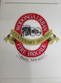
Book - Wodonga Urban Fire Brigade Centenary 1893- 1993, Country Fire Authority Victoria, C. 1993
The Wodonga Fire Brigade was founded in 1893 from a need to protect life and property in what was a small town straddling the Melbourne-Sydney railway line. This book traces the first 100 years of its development and service to the community.The Wodonga Fire Brigade was founded in 1893 from a need to protect life and property in what was a small town straddling the Melbourne-Sydney railway line. This book traces the first 100 years of its development and service to the community.history wodonga urban fire brigade, cfa wodonga -
 Wodonga & District Historical Society Inc
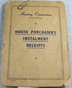
Financial record - Housing Commission Victoria House Purchaser's payment book, C. 1950's
The Housing Commission of Victoria (HCV) was established by the Victorian Government in 1938 after a public campaign for housing reform. After 1942 the HCV was responsible for developing regional and outer suburban housing estates where low-income families were located in proximity to expanding population areas and post-war industries. With greater funding and a severe housing shortage, the Commission's activities greatly expanded through the late 1940s into the 1950s. They began to build larger and larger estates of housing in the suburban fringes, as well as country towns The Housing Commission was largely responsible for the development of Wodonga up to 1973 and in 1975 was said to have built one-third of all homes in Wodonga, though many of these were handed to the Army. Criticism of the bureaucratic and undemocratic nature of the Commission and scandals over corruption in relation to housing developments in Melbourne's fringe areas resulted in the disbandment of the HCV and the formation of a Ministry of Housing in 1984. The work of the Housing Commission of Victoria allowed many people in Wodonga to acquire affordable housing and pay it off over time through monthly instalments. This booklet is of local and state significance as it is evidence of the role of the Victorian Government is providing access to affordable housing. It supported the development of Wodonga and the realisation of the "Australian dream" of home ownership.A small receipt book issued by the Housing Commission of Victoria to record payments and receipts for tenants who were purchasing their home through the Housing Commission. Monthly installments allowed people to access and purchase, affordable housing. On the front cover "Housing Commission/VICTORIA/ HOUSE PURCHASER'S/ INSTALMENT/RECEIPTS"housing wodonga, housing commission of victoria, public housing wodonga -
 Port Melbourne Historical & Preservation Society
Audio - Urban Planning, Dr Robyn Clinch, John Kirby, 28 Jul 2014
Dr Robyn Clinch discusses the history, development and workings of urban planning. Duration 1.33.27 PMHPS meeting.town planning, heritage, robyn clinch -
 Bendigo Historical Society Inc.
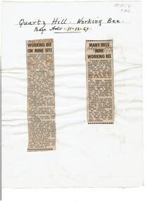
Newspaper - Quartz Hill Working Bee, 1967
... . ' Members of the Tourist Development Association and the Town Clerk... Development Association and the Town Clerk, Mr. A.J. Watts, cleared ...Quartz Hill is situated on the Sheephead line of reef and is situated just south of where the Red, White and Blue Consolidated Gold Mine operated. Two newspaper cuttings affixed to lemon backing sheet. Written on top in black pen: 'Quartz Hill Working Bee, Bdgo Adv. 11.12.67' Cutting one, 'Working Bee on Mine Site' with 7.12.67 written across the top, describes an appeal to get volunteers to clear the site of former mines on Quartz Hill. This is anticipated to 'clear the site of accumulated debris and clean out the two large adits driven into the hill and thus make the site a 'tourist visiting spot'. Cutting two, 'Many Miss Mine Working Bee' dated 11.12.67, describes the poor response to the working bee. ' Members of the Tourist Development Association and the Town Clerk, Mr. A.J. Watts, cleared 175 feet of the Northern tunnel and cut an entrance way and steps in the Southern tunnel of the New Blue Mine area in the first stage of the mining project. Mr. J. Stanistreet said last night he was most disappointed. He said: 'apparently we picked the wrong time of the year'.mining, sandhurst, new blue consolidated gold mine, red white and blue consolidated gold mine, quartz hill, sheepshead reef line, a.j. watts, j. stanistreet, bob long -
Port Melbourne Historical & Preservation Society
Book, Making the Most of the Bay, Apr 1989
'Making the Most of the Bay'- a draft plan for the protection and development of Port Phillip and Corio Bays, 1989. A draft plan to guide decision making. Introduction by Tom Roper, Minister for Planning and Development. (Refer item 1048, final version)state government victoria, natural environment, town planning -
Port Melbourne Historical & Preservation Society
Audio - 3LO interview with Kate Shaw and Robert Peck re Sandridge City Bayside Development, Pat Grainger, 10 Mar 1988
Extract from ABC radio 3LO program presented by Romona Kovall, interviewing Kate Shaw and Robert Peck re the proposed Sandridge City Bayside DevelopmentDuration 00:17:40town planning - proposals shelved - bayside, romona kovall, kate shaw -
Port Melbourne Historical & Preservation Society
Audio - Radio Interviews, Dr Kim Dovey, Robert Peck, Greg Flynn re Sandridge City Development plan, 27 Nov 1991
Radio interviews with Dr Kim Dovey, Robert Peck, Greg Flynn, re the Sandridge City plan and the cleanup of the site. Recording 27.11.1991 and other dates, duration 30:48town planning - proposals shelved, dr kim dovey, robert peck, greg flynn -
Port Melbourne Historical & Preservation Society
Audio - Oral History, Bayside Development, Pat Grainger, 8 May 2003
Oral History of Pat Grainger, recorded 08.05.2003. Discussing the proposed Sandridge City development. Bayside Archival Project. Recording duration 01:15:56built environment, town planning - proposals shelved, pat grainger -
Port Melbourne Historical & Preservation Society
Audio - Oral History, Bayside Development, Noel Turnbull, Janet Bolitho, 16 Feb 2004
Oral History of Noel Tunbull, recorded by Janet Bolitho on 16.02.2004. Discussing the Bayside Archival Project the proposed Sandridge City Development. Recording duration 47:11built environment, town planning - proposals shelved, noel turnbull -
Port Melbourne Historical & Preservation Society
Audio - Oral History, Bayside Development, Lyn Allison, Janet Bolitho, 12 Jun 2004
Oral History of Lyn Allison, recorded by Janet Bolitho on 12.06.2004. Discussing the Bayside Archival Project the proposed Sandridge City Development. Recording duration 54:44built environment, town planning - proposals shelved, lyn allison -
Port Melbourne Historical & Preservation Society
Audio - Oral History, Bayside Development, John Drury, Janet Bolitho, 17 Jul 2004
Oral History of John Drury, recorded by Janet Bolitho on 17.07.2004. Discussing the Bayside Archival Project the proposed Sandridge City Development. Recording duration 47:11built environment, town planning - proposals shelved, john drury -
Port Melbourne Historical & Preservation Society
Audio - Oral History, Bayside Development Proposal, Ronald 'Bunna' Walsh, 14 Jul 2004
Oral History from Ronald "Bunna" Walsh on Bayside Development Proposal (discussing the proposed Sandridge City development). Recording made by Janet Bolitho at Port Town Hall on 14.07.2004 Recording duration 25:26built environment, town planning - proposals shelved, ronald 'bunna' walsh -
Port Melbourne Historical & Preservation Society
Audio - Oral History, Bayside Development Proposal, Brian Couldrey, 12 Jan 2004
Oral History from Brian Couldrey on Bayside Development Proposal (discussing the proposed Sandridge City development). Recording made by Janet Bolitho on 12.01.2004 Recording duration 32:51built environment, town planning - proposals shelved, brian couldrey -
Lakes Entrance Historical Society
Book, Stevens M I, Township of Cann River, Parish of Noorinbee, County of Croajingolong, 1977
An account of the development of the Cann River town and district in Gippsland, Victoria, compiled for the 50th. anniversary of the Cann River school. Includes list of pupils and head teachers, information on other schools, and recollections of residents.settlers, schools, township -
Broadmeadows Historical Society & Museum
Book - Publication, Broadmeadows District Centre Structure Plan, 1988
... Details Development of Town Centre Structure Planning Broadmeadows ...Written For City of Broadmeadows and Ministry for Planning and EnvironmentHardcover, 104pp. Report in house-bound cover by Merri-bek City Libraries (Formally Moreland City Libraries)non-fictionWritten For City of Broadmeadows and Ministry for Planning and Environmentstructure, planning, broadmeadows, city of broadmeadows, town centre -
 The Beechworth Burke Museum
Photograph, c. 1900
This black and white photograph shows the front view of the Ovens Benevolent Home with one person sitting on a bench seat against the nearest part of the building and another person walking on the grass. This photo is estimated to have been taken in the early 1900’s when the Ovens Benevolent home would have still been fairly contemporary. According to Woods (p. 121) in the 1860’s the government spent considerable sums to establish several public buildings such as the Benevolent Asylum, the Hospital and Insane Asylum to support those in need of care in the area directly after the Indigo gold rush which had left Beechworth, a fairly remote regional and newly formed township (Gold was first discovered in Beechworth in 1852) with a number of infirm and destitute people in its wake and which due to the support and establishment of these facilities ‘made Beechworth a significant social welfare centre in Victoria’ (Woods, p. 121). Originally named the Benevolent Asylum, the building was renamed as The Ovens Benevolent Asylum in 1935 and again to The Ovens and Murray Home in 1954. The building construction began in 1862 and was unique in its features of Flemish Gothic Revival style which utilised red brick and granite, ‘the main facade is dominated by four curved, Flemish gable ends, […] incorporates paired windows of pointed Gothic form and dark brick diaperwork patterning. The adjacent J. A. Wallace Wing of 1899 was designed by Donald Fiddes as a separate building. Also constructed of red brick, Fiddes adopted a conservative approach, designing a simple domestic scale building with central projecting gable porch and flanking bull nosed verandahs.’ (https://vhd.heritagecouncil.vic.gov.au/places/118). Initially established to provide housing and care for aged, orphaned or widowed members of the population, over time the Ovens Benevolent Home focused more on the age care responsibility which functioned as such up until 2005.The Ovens Benevolent Home is significance due to its association with the early development of Beechworth. It shows the civic, social welfare development that took place in the town after the peak of the gold rush which helps to establish the character of the community being built at the time and their cultural values at play. This photograph also clearly shows the early functioning landscape of that building and its purpose as well as the significant elements of its aesthetic significance and unique and striking architectural forms of the building.Black and white rectangular photograph [copy from slide]Reverse: / 7588 /housing and care, aged care, donald fiddes, ovens benevolent home, flemish gable, brick diaperwork, photograph, black and white photograph, public building, benevolent asylum, indigo gold rush, beechworth, the ovens and murray home -
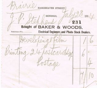 Bendigo Historical Society Inc.
Document - BAKER & WOODS ELECTRICAL ENGINEERS AND PHOTO STOCK DEALERS, 23/07/1914
Established in 1897, Baker and Woods were initially electricians. The property in Hargreaves was taken over by a saddler and Baker and Woods moved to premises at 313 Hargreaves Street. The business expanded to include photographic equipment, phonographs and phot development. In 1903, Baker and Woods were responsible for converting the gas lighting in the Bendigo Town Hall to electricity. A fire caused by a short circuit caused extensive damage to the building in 1914.Baker & Woods Electrical Engineers and Photo Stock Dealers. Cream paper with Black print. At the top Hargreaves Street, Bendigo, Docket 221. Bought of Baker & Woods, Electrical Engineers and Photo Stock Dealers. Written in Pencil on the Docket is *Prairie. July 18 1914. Mr J. R. Stephens. Items listed:- Developing Film 1/6, Printing 24 Postcards 3/- 6/, postage -4p = 7/10. On the back written in blue biro is - 1290B. Box 625business, retail, photography, hargreaves street bendigo. baker & woods. -
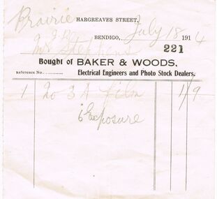 Bendigo Historical Society Inc.
Document - BAKER & WOODS ELECTRICAL ENGINEERS AND PHOTO STOCK DEALERS, 18/07/1914
Established in 1897, Baker and Woods were initially electricians. The property in Hargreaves was taken over by a saddler and Baker and Woods moved to premises at 313 Hargreaves Street. The business expanded to include photographic equipment, phonographs and phot development. In 1903, Baker and Woods were responsible for converting the gas lighting in the Bendigo Town Hall to electricity. A fire caused by a short circuit caused extensive damage to the building in 1914.Baker & Woods Electrical Engineers and Photo Stock Dealers: Cream paper with black print. At the top is *Hargreaves Street, Bendigo 1914. Brought of Baker & Woods, Electrical Engineers and photo Stock Dealers. Docket no. 221. Hand written in pencil is Prairie. Mr J.R. Stephens. Items purchased were:- 1 No. 3 A film, 6 Exposure cost 1/9. Dated July 18th 1914. Box 625business, retail, photography, hargreaves street. baker & woods. -
 Eltham District Historical Society Inc
Document - Report, Dimity Reed et al, Advisory Commlttee Hearing on Permit Applications 96/0376, and 96/0377, and on Planning Appeals 96/40724 and 96/40812 re a proposed convenience centre at 895 Main Road, Eltham, June 1997
... and orderly development of the Eltham Town Centre, excessive noise... and orderly development of the Eltham Town Centre, excessive noise ...On 15 December 1994 the former Shire of Eltham ceased to exist following the Liberal Kennett Government local council amalgamations. A new Nillumbik Shire Council was established with unelected commissioners appointed. That Council sold the former Eltham Shire Council Offices and land at 89S Main Road Eltham to Dallas Price Homes Pty. Ltd. the sale being conditional upon the granting of a planning permit for a petrol station/convenience store, fast food and video outlet. The sale was conditional that if the permit was not granted by 30 August. 1997, the contract could be avoided by either the purchaser or the vendor. The proposed development consisted of a petrol station with undercover fuelling facilities, convenience shopping, a drive through service facility for fast food, an 80 seat cafe, automated banking, a children's play area and retail space. In addition, the proposal included a 200 square metre community facility for Council use, provision of on site carparking over 2 levels for 83 vehicles, and advertising signage. The Advisory Committee was appointed under Section 151 of the Planning and Environment Act 1987 to hear submissions on the proposal to develop the land at 895 Main Road Eltham, the site of the former Eltham Shire Offices. In September 1996, two applications were made by Contour Consultants Australia Pty Ltd on behalf of Dallas Price Homes Ply Ltd, to Nillumbik Shire Council. After extensive notification, the Council received 213 objections and a petition of over 1400 signatures. On October 9, 1996, Nillumbik Shire Council issued Notices of Decision to Grant Permit on Applications number 96/03376 and 96/0377 for the use and development of the land as a convenience Centre consisting of a petrol station, convenience store, cafe/takeaway food premises, a retail facility and a community facility, with associated advertising signs. Objectors to the proposals lodged Planning Appeals number 96/40724 and 96/40812 with the Administrative Appeals Tribunal on November 1, 1996. The grounds of appeal can be summarised as: inappropriate development, insufficient carparking, traffic and access issues, unsatisfactory design, inadequate permit conditions, the proposal being out of character with the area. and being contrary to the purpose and orderly development of the Eltham Town Centre, excessive noise, lack of consultation and unsuitable signage. On November 13, 1996, the Minister for Planning and Local Government directed the Registrar of the Administrative Appeals Tribunal. under Section 41 (1) (a) of the Planning Act 1980, to refer the Appeals to the Governor in Council for determination without a hearing or recommendation by the Tribunal. The Minister for Planning and Local Government called in the Appeals as he considered that they raised major issues of policy relating to the facilitation of development in accordance with the objectives set out in Section 4 of the Planning and Environment Act 1987, and that determination of the Appeals could have a substantial effect on the achievement of these planning objectives. The Minister required the Advisory Committee to consider the planning merits of the proposed use and development, and to address the issues raised in the objections. The Advisory Committee was required to produce a report providing: • The Committee's response to the matters detailed; • Relevant supporting information for the Advisory Committee's recommendation; and • A description of the proceedings conducted by the Advisory Committee and a list of those consulted or heard by the Committee. In March 1997, elections were held in the Shire of Nillumbik and the view of the new Council to this proposal differed from the view held by the earlier Council Hence the Submission made to the Committee by the Shire was against the decision by the Shire of Nillumbik to issue the Notices of Decision to Grant a Permit. The Recommendations of the Advisory Committee were: i. The cafe and take away food premises are as of right uses and are therefore allowable, but that shop and petrol station are unacceptable uses. A community facility is a discretionary use and is acceptable. ii. A development of the type and scale proposed is totally inappropriate for this land and that the Applications number 96/03376 and 96/0377 for the use and development of the land as a convenience Centre consisting of a petrol station, convenience store, café/takeaway food premises, a retail facility and a community facility, with associated advertising signs, be refused. iii. The land should be rezoned for public purposes and should remain in the community's ownership for community use. 895 main road, advisory committee, dallas price homes, eltham, eltham shire office, nillumbik shire council, planning application, administrative appeals tribunal -
 Eltham District Historical Society Inc
Document - Report, Paul Jerome, Advisory Committee on a Proposed Convenience Centre and an Alternative Shire Proposal - Eltham Gateway Community Precinct Concept Plan - 895 Main Road Eltham, October 1997
... and orderly development of the Eltham Town Centre, excessive noise... and orderly development of the Eltham Town Centre, excessive noise ...On 15 December 1994 the former Shire of Eltham ceased to exist following the Liberal Kennett Government local council amalgamations. A new Nillumbik Shire Council was established with unelected commissioners appointed. That Council sold the former Eltham Shire Council Offices and land at 89S Main Road Eltham to Dallas Price Homes Pty. Ltd. the sale being conditional upon the granting of a planning permit for a petrol station/convenience store, fast food and video outlet. The sale was conditional that if the permit was not granted by 30 August. 1997, the contract could be avoided by either the purchaser or the vendor. The proposed development consisted of a petrol station with undercover fuelling facilities, convenience shopping, a drive through service facility for fast food, an 80 seat cafe, automated banking, a children's play area and retail space. In addition, the proposal included a 200 square metre community facility for Council use, provision of on site carparking over 2 levels for 83 vehicles, and advertising signage. An Advisory Committee consisting of Dimitry Reed and Margaret Pitt was appointed under Section 151 of the Planning and Environment Act 1987 to hear submissions on the proposal to develop the land at 895 Main Road Eltham, the site of the former Eltham Shire Offices. In September 1996, two applications were made by Contour Consultants Australia Pty Ltd on behalf of Dallas Price Homes Ply Ltd, to Nillumbik Shire Council. After extensive notification, the Council received 213 objections and a petition of over 1400 signatures. On October 9, 1996, Nillumbik Shire Council issued Notices of Decision to Grant Permit on Applications number 96/03376 and 96/0377 for the use and development of the land as a convenience Centre consisting of a petrol station, convenience store, cafe/takeaway food premises, a retail facility and a community facility, with associated advertising signs. Objectors to the proposals lodged Planning Appeals number 96/40724 and 96/40812 with the Administrative Appeals Tribunal on November 1, 1996. The grounds of appeal can be summarised as: inappropriate development, insufficient carparking, traffic and access issues, unsatisfactory design, inadequate permit conditions, the proposal being out of character with the area. and being contrary to the purpose and orderly development of the Eltham Town Centre, excessive noise, lack of consultation and unsuitable signage. On November 13, 1996, the Minister for Planning and Local Government directed the Registrar of the Administrative Appeals Tribunal. under Section 41 (1) (a) of the Planning Act 1980, to refer the Appeals to the Governor in Council for determination without a hearing or recommendation by the Tribunal. The Minister for Planning and Local Government called in the Appeals as he considered that they raised major issues of policy relating to the facilitation of development in accordance with the objectives set out in Section 4 of the Planning and Environment Act 1987, and that determination of the Appeals could have a substantial effect on the achievement of these planning objectives. The Minister required the Advisory Committee to consider the planning merits of the proposed use and development, and to address the issues raised in the objections. The Advisory Committee was required to produce a report providing: • The Committee's response to the matters detailed; • Relevant supporting information for the Advisory Committee's recommendation; and • A description of the proceedings conducted by the Advisory Committee and a list of those consulted or heard by the Committee. In March 1997, elections were held in the Shire of Nillumbik and the view of the new Council to this proposal differed from the view held by the earlier Council Hence the Submission made to the Committee by the Shire was against the decision by the Shire of Nillumbik to issue the Notices of Decision to Grant a Permit. The Recommendations of the Advisory Committee were: i. The cafe and take away food premises are as of right uses and are therefore allowable, but that shop and petrol station are unacceptable uses. A community facility is a discretionary use and is acceptable. ii. A development of the type and scale proposed is totally inappropriate for this land and that the Applications number 96/03376 and 96/0377 for the use and development of the land as a convenience Centre consisting of a petrol station, convenience store, café/takeaway food premises, a retail facility and a community facility, with associated advertising signs, be refused. iii. The land should be rezoned for public purposes and should remain in the community's ownership for community use. Following this, the Minister for Planning and Local Government, the Hon. Robert Maclellan, appointed Mr. Paul Jerome as an Advisory Committee under section 151 of the Planning and Environment Act 1987 to consider a Convenience Centre and an alternative proposal by Iha Shire of Nillumbik being the Eltham Gateway Community Precinct Concept Plan for the site of the former Shire of Eltham municipal offices at 895 Main Road, Eltham. In summary, the terms of reference for the Advisory Committee required it to: • consider the merits of the Council proposal • examine the merits of both proposals in terms of net community benefit • address the report of the previous Advisory Committee on the Convenience Centre proposal The Advisory Committee inspected the site and considered all the material before It including submissions made by all parties to the previous Advisory Committee and correspondence received by the Department of Infrastructure both before and after that Committee submltted its report. The Advisory Committee also held discussions with the following people: • Cr. Robert Marshall • Cr. Margaret Jennings • Cr. Lex de Man • Mr. Dallas Howgate of Dallas Price Properties, also Dallas Price Homes • Mr. Barry Rochford, CEO, Shire of Nillumbik • Ms. Yvonne Rust, Planning Officer, Shire of Nillumbik • Mr. Gregory Burgess, Architect of the Eltham Library and of Council’s Community Precinct Concept Plan • Mr. Jim Connor representing Mrs Thelma Barkway of the Eltham Senior Citizens Club Having considered all the material before it, the Committee arrived at two basic conclusions. First, the DPP proposal should be rejected because, on its merits, It does not sufficiently satisfy the requirements of the planning scheme which is a statutory document. The planning scheme requires that, before making a decision on the permit applications for the DPP proposal, a range of matters must be considered. It follows that consideration of these matters should Influence the decision. These matters include local policies relating to character and amenity. In particular, these policies seek • to conserve and enhance the bushland/country atmosphere, artistic heritage and strong sense of community of the Eltham Town Centre by ensuring that the design and height of any new development is sympathetic to existing buildings • to achieve a pleasing physical environment within the Eltham Town Centre by encouraging a high standard of architecture and urban design • to encourage Improvement to pedestrian amenity through such facilities as open and shattered rest areas and meeting places, crossing facilities, pedestrian arcades, pedestrian links to car parks and pedestrian weather protection • to reduce conflict between vehicular traffic and pedestrian flows, and • to encourage pedestrian thoroughfares It is submitted, as set out In the main body of this report, that the DPP proposal fails substantially to meet these policies and In so doing does not merit the exercise of discretion In Its favour with the Issuing of a permit. This finding is not offset by the investment and employment attributes of the proposal. They do not override the need to comply with the planning scheme. Second, the Council proposal, on Its own merits, substantially meets all statutory requirements applicable to this site with a possible reservation about car parking and traffic management which need further definition and assessment as the concept is refined. The Council proposal, however, has a serious weakness in that Its financial viability has not been adequately tested. The Committee refers to 'financial' rather than 'commercial' viability in recognition that Council owns the land and may enter into a range of agreements and partnerships to realise its concept some of which may be truly commercial and some of which may involve an element of subsidy arising from Council's involvement as a public body acting on behalf of its community. The Committee concludes that Council should be given the opportunity, within a reasonable timeframe to establish the financial feasibility of its concept and should develop a strategy for the future of Its land asset at 895 Main Road in the event that Its concept for the site cannot be realised. 895 main road, advisory committee, dallas price homes, eltham, eltham shire office, nillumbik shire council, planning application, administrative appeals tribunal -
Glen Eira Historical Society
Document - Historic Conservation Areas Project
Contains 4 items relating to historic conservation: 1/Five newsletters (one page each newsletter, dated 07/1975, 08/1975, 09/1975, 10/1975 and the final one 12/1975) describing how the project evolved, project funds, progress, study method, project 1 report, project 2 report and summary as no further funds available. Project was to include all of Melbourne but funding did not allow this. Note: newsletters stamped with Caulfield Historical Society. 2/Letter (one page on official city of Caulfield letterhead) from Andrew Rodda (manager planning) to Hazal Ford (dated 13/11/1989) describing ‘council resolved on 18/07/1989 to proceed with preliminary conservation survey’ and mentions that a copy is included. 3/Preliminary conservation survey for the City of Caulfield (nine pages) describing background, study area, budget, purpose, study outline, timeframe, report format, ownership, tasks and background information (mentions number and types of houses and properties as at 1986 and 1988) and a map of City of Caulfield. 4/Booklet (28 pages) titled ‘Heritage Area – Caulfield North Draft Heritage Guidelines July 1999 – City of Glen Eira’, containing Caulfield North Heritage Area, cultural heritage, Heritage Overlay Area, architectural description, common architectural forms and features, development guidelines, key design checklist. It includes a map of the Caulfield North Heritage Overlay Area, two illustrations about the development envelope and many black-and-white photographs of houses and architectural features.historic conservation areas project niven barbara, newsletters, town planning, historic buildings, heritage studies, housing, royal historical society of victoria (rhsv), read michael, plans, local government, historical societies, committee for urban action (cua), national trust, hopkins sherry ms., ford hazel, preliminary conservation survey, town planning, heritage studies, rodda andrew, city of caulfield, housing estates, victoria national estate grants program, australia icomos, burra charter, buildings structures and establishments, land surveys, suburbs, historic buildings, architectural significance, ‘caulfield’s heritage study’, soloman geulah dr., caulfield library, dandenong road, nepean highway, hotham street, iknerman road, orrong road, north road, poath road, ‘plan of the city of caulfield’, north ward, east ward, south ward, west ward, kooyong road, neerim road, bambra road, balaclava road, shire of caulfield, railways, world war 1914-1918, depression 1929-1939, rippon lea, labassa, parks, mansions, community services, ‘caulfield north draft heritage guidelines july 1999’, city of glen eira, caulfield north heritage area, glen eira heritage management plan, mayfield grove, normanby avenue, carnarvon street, glenferrie street, arthur street, malakoff street, normanby road, heritage advisory service, construction materials, victorian style, mediterranean style, spanish mission style, californian bungalow style, federation style, architectural style, architectural features, heritage conservation design, building construction, building regulations, aboriginal peoples, carnarvon road -
 Eltham District Historical Society Inc
Document - Folder, Jim Connor et al, Eltham Gateway, 1987
The Eltham Gateway Group (EGG) was established about 1987 by some Eltham residents concerned for the development of the Eltham Gateway, defined as that historically and environmentally sensitive region of land along Main Road, Eltham extending from the roundabout at Fitzsimons Lane to Dudley Street, Eltham. The gateway was a unique urban area with a strong sense of character that provided a distinctive entrance to the Eltham Town Centre. The intention of this group was to support development that preserved both the natural and historic features of the gateway region. It encouraged development sympathetic to Eltham’s traditional association with the arts and natural environment. The group was initiated in response to a planning application in December 1986 to redevelop the then Mobil service station site at 729 Main Road, Eltham on the corner of Brougham Street. This group worked with and encouraged the Eltham Shire Council to consider rezoning to protect the gateway area. A detailed Eltham Gateway Study undertaken by Tract Consultants assisted with the establishment of the Eltham Gateway Zone, the Eltham Gateway Policy and the Eltham Gateway Design and Siting Guidelines. The State Government subsequently agreed to a planning amendment to rezone the land from a Residential Zone C to an Eltham Gateway Zone under the Eltham Planning Scheme. While zoning changes over the years have altered the mix of permitted uses within this area the Eltham Gateway still looks and feels like a predominately residential style precinct, even where non-residential type uses operate. EGG was followed by the establishment of the Eltham Protection Society in about 1989 to respond to community planning issues beyond the area of the Eltham Gateway and in effect took over the role from the EGG. Jim Connor President Eltham District Historical Society 4 July 2022 During 1986/87 I was a community member on the Shire of Eltham’s Community Consultative Committee involved with the Eltham Gateway Study, which led to the establishment of the original Eltham Gateway Zone, under the then Eltham Planning Scheme The Eltham Gateway Group was the pioneer community action group dedicated to protecting the character of the Eltham Gateway. It was succeeded by the Eltham Protection Society. When the Shire of Eltham Offices were demolished by the unelected Commissioners of Nillumbik Shire Council in July/August 1996, significant community upset and protest led to the establishement of the Eltham Gateway Action Group (EGAG) which in present day form has evolved into the Eltham Community Action Group (ECAG) focussing on issues throughout Eltham and not just the Eltham Gatewayeltham community action group, eltham gateway, eltham gateway action group, eltham gateway design and siting guidelines, eltham gateway group (egg), eltham gateway policy, eltham gateway study, eltham gateway zone, eltham planning scheme, eltham protection society, jim connor, michael wilson, rodger dalling, tony mcmanus -
 Bacchus Marsh & District Historical Society
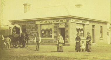
Photograph, Alford's Little Wonder Store Bacchus Marsh 1883
The Little Wonder Store was built in 1883 from materials of the demolished Maddingley School. It was located on the corner of Grant Street and Labilliere Street. In 1886 James Alford obtained a licence to conduct the Railway Hotel and General Store there. A second storey was added later and the building continued to operate as the Railway Hotel. It was destroyed by fire in 1998. The photo also shows the covered wagon of a travelling salesman, who were known as ‘hawkers’, who were significant in the supply of goods and news to outlying towns and districts before the development of road and rail networks. Small sepia 'carte de viste' style unframed photograph on card with gold border framing photograph. Housed in the Jeremeas Family Album which contains photographs of Bacchus Marsh and District in 1883 by the photographers Stevenson and McNicoll. The photo shows a single-storey building of bluestone and brick with two signs on the front and side, the front sign reading “THE LITTLE WONDER” and the side sign “GENERAL STORE”. Above the door is a sign with the name ‘James Alford’. The windows display the merchandise of the store. Outside the store is a travelling salesman’s cart pulled by two horses. The salesman sits in the cart ready to drive off. Standing along the street outside the store are three men, three women and two young children.Printed On the front: Stevenson & McNicoll. Photo. 108 Elizabeth St. Melbourne. COPIES CAN BE OBTAINED AT ANY TIME. On the back: LIGHT & TRUTH inscribed on a banner surmounted by a representation of the rising sun. Copies of this Portrait can be had at any time by sending the Name and Post Office Money Order or Stamps for the amount of order to STEVENSON & McNICOLL LATE BENSON & STEVENSON, Photographers. 108 Elizabeth Street, MELBOURNE. stevenson and mcnicoll 1883 photographs of bacchus marsh and district, shops bacchus marsh, general stores bacchus marsh vic., hawkers, hotels bacchus marsh -
 Mission to Seafarers Victoria
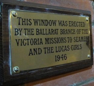
Plaque - Memorial Plaque, Ballarat Branch and Lucas Girls, 1946
The Ballarat Branch Committee and girls of Lucas & Co. raised the money for the memorial window in Good Chapel of Saint Peter which is dedicated to the men of the Jervis Bay and all Merchant seamen who gave their lives in the world wars. To see a picture of the actual window go to VC database Mtsv record 0035.Regionally based support across Victoria provided crucial funds to the Mission for Seafarer welfare, activities and operations. This support was very often sourced either through a country Auxiliary group based in places such as Ballarat, Camperdown, Hamilton, Bendigo and other similar towns or centres. Op shops and CWA, Church Auxiliaries and other similar charities mainly operated by the womenfolk of the respective communities, recognized the vital importance of 19th and 20th C Merchant and Military Naval services to the development of Australia. The cumulative local fundraising efforts helped maintain the work of the Coastal based Mission services to seafarers.Rectangular brass plaque mounted to wood board.This window was erected by the Ballarat Branch of the Victoria Missions to Seamen and the Lucas Girls 1946.ballarat, lucas girls, lucas & co., 1946, window, plaque, ww2, world war 2, textile company, lucas clothing factory -
 Sunbury Family History and Heritage Society Inc.
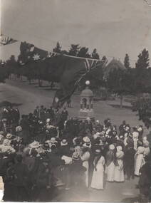
Photograph, Starkie Memorial Fountain, 26th February 1915
... development in the town. Joseph Starkie J.D.Starkie Memorial Stawell ...The photograph was taken in 1915 at the opening of the Starkie Memorial Fountain that was erected at the intersection of Brook, O'Shanassy and Stawell Streets in Sunbury Township. Joseph Starkie was instrumental in establishing a reliable water supply which was turned on 13th March 1905. The fountain was erected in recognition of his contribution to the town 10 years later on 26th February 1915. As the town grew and the main shopping strip became busier, it was relocated to a memorial site opposite the Memorial Hall.The Starkie Fountain is one of Sunbury's important memorials erected to celebrate an important development in the town.A non-digital black and white photograph of a crowd of people are gathered around a monument for a ceremony. Flags are festooned above the crowd and an open parkland is in the background as well as a church. Details of the event are handwritten on the back of the photograph.joseph starkie, j.d.starkie memorial, stawell street, sunbury, water fountain