Showing 112626 items
matching tracks/roads
-
 Glen Eira Historical Society
Album - Album page, Kambrook Road, Circa 1972
This photograph is part of the Caulfield Historical Album 1972. This album was created in approximately 1972 as part of a project by the Caulfield Historical Society to assist in identifying buildings worthy of preservation. The album is related to a Survey the Caulfield Historical Society developed in collaboration with the National Trust of Australia (Victoria) and Caulfield City Council to identify historic buildings within the City of Caulfield that warranted the protection of a National Trust Classification. Principal photographer thought to be Trevor Hart, member of Caulfield Historical Society. Most photographs were taken between 1966-1972 with a small number of photographs being older and from unknown sources. All photographs are black and white except where stated, with 386 photographs over 198 pages. https://vhd.heritagecouncil.vic.gov.au/places/43737 - re 26 Kambrook Road and 345 Balaclava Road corner building: A prominently situated two-storeyed complex of late Victorian buildings consisting of "Wybar's Buildings" occupying the Balaclava Road/ Kambrook Road corner and the "Caulfield Bakery" facing Kambrook Road, separated by a driveway from a single storeyed shop. The main building has a comer splay and balustraded parapet with curved pediments, the words "Wybar's Buildings 1887" having been obliterated but "Caulfield Bakery 1887" with the characteristic wheatsheaf surviving in raised cement work. The walls are stuccoed and richly ornamented with bracketed cornices and keystones with masks extending to the Bakery. The main building is further distinguished by the Masonic symbol of the mason's dividers in the pediment whilst the upper level of the bakery is in overpainted brickwork. The single storeyed shop incorporates the bracketed cornice and consoles characteristic of the main buildings and is in other respects a utilitarian structure. https://vhd.heritagecouncil.vic.gov.au/places/35413 - re 16 Kambrook Road A small late Victorian Italianate villa distinguished by its parapeted window bays either side of a small verandah with encaustic tiled floor. The parapets are balustraded with console enrichment and glazed tiles, the stuccoed surfaces being unpainted. Ornamentation is in other respects undistinguished. https://www.gleneira.vic.gov.au/services/planning-and-building/heritage/heritage-management-plan - re 9-11 Kambrook Road ... they demonstrate most of the commonly employed aesthetic devices characteristic of the Italianate Style including patterned brickwork, patterned slate roofs, cast iron lace verandahs, ornamental stucco work and ashlar boards...https://vhd.heritagecouncil.vic.gov.au/places/43737 - 345 Balaclava and 26 Kambrook Roads HO91 in City of Glen Eira "Wybar's Buildings" at the corner of Balaclava Road and Kambrook Road are important as a prominent late Victorian commercial development incorporating a variety of activities including a bakery and possibly a coffee palace, the latter understood to be unique within the municipality, but characteristic of the period. It is a rare complex of its type in Caulfield and is important also as evocative evidence of the late Victorian Land Boom and the creation of a small now defunct commercial centre at this location by the George Wybrow. https://vhd.heritagecouncil.vic.gov.au/places/35413 - 16 Kambrook Road HO121 in City of Glen Eira ''Hollywood'' at 16 Kambrook Road is of architectural interest for its pavilions which retain their unpainted parapets and ornamental tiles in the manner of other less imposing examples in the immediate locality possibly linked with the builder George Wybar and his son, who undertook substantial projects nearby. Its association with James Yorston, presumably is Yorston of Dickson and Yorston, important builders and estate developers at Caulfield during the Inter war period is of interest. https://www.gleneira.vic.gov.au/services/planning-and-building/heritage/heritage-management-plan - re 9-11 Kambrook Road HO152 Normanby Road/Kambrook Road, Caulfield North Statement of Significance: The Precinct is historically significant for its capacity to demonstrate standards of design and building construction in this part of the municipality during the late Land Boom years and especially just prior to the bank collapse of 1891. The housing stock is representative of the standards of amenity excepted by the middle classes of Melbourne society at the time, including artists, (horse) trainers, jockeys, managers, travellers, journalists and the like, also having a functional link with the activities of the Caulfield Racecourse which forms an important element in the history of the Municipality. The row of attached pairs at 5-11 Kambrook Road and 53-67 Kambrook Road is especially significant in this respect in that the narrow allotments are indicative of the owner/developer’s determination to maximise profits at the height of the Land Boom in 1891...Page 104 of Photograph Album with four photographs (landscape) of three different properties on Kambrook Road.Handwritten: Kambrook Road [top right] / WYBAR'S BUILDING 1887/ INC CAULFIELD BAKERY / [under top right photo] / 16 KAMBROOK ROAD / 1970 HIRST MRS J.N.[under bottom left photo] / 11-9 KAMBROOK ROAD / 1970 9-BUCKLAND MRS L.A / 11- ATKINS MRS N.E. [under bottom right photo] / 104 [bottom right]trevor hart, kambrook road, victorian, caulfield north, parapets, wybar's buildings 1887, caulfield bakery 1887, architectural features, painted bricks, balaclava road, victorian italianate style, houses, bay windows, verandahs, glazed tiles, shops, george wybar, builders, james yorston, dickson and yorston, j n hirst, l a buckland, n e atkins, patterned slate roofs, patterned bricks, cast iron work, attached houses -
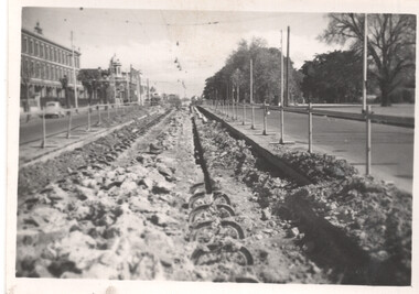
![Construction of the electric tram line in Cotham Road [Kew]](/media/collectors/550653872162f11fb04854aa/items/66288f7f6214a76cee3ea3d8/item-media/66288fe96214a76cee3ead36/item-fit-380x285.jpg) Kew Historical Society Inc
Kew Historical Society IncPhotograph - Construction of the electric tram line in Cotham Road [Kew], E.J. Dower, 1913
One of a small album of six photographs of the construction of the Cotham Road tramline in Kew, taken by Edgar James Dower in the second decade of the twentieth century. The reverse of each photo contains notes, written over time by the photographer, which are contained in the 'Inscriptions' field. Born and raised in Olinda, Dower's family later moved to Surrey Hills. He worked as an adult as a clerk in the city office of the Metropolitan Gas Company, and in his role as a 'collector', he was able to photograph scenes including the construction of tram and train lines and associated buildings in Kew, Hawthorn, Camberwell and Surrey Hills. Later he established a real estate agency with his brother - the E.J. Dower Real Estate Agency, Dandenong Office. The album as a whole can be viewed separately as the parent file.The image is an historically significant record of the development of transport infrastructure which was used to connect Victorians in the first two decades of the twentieth century. This development resulted from increases in population and the consequent extension of Melbourne's suburbs. The photographs in the album, as well as Dower's single photos mounted on card, individually and collectively richly detail the labour of workers and the tools and machinery used to create and extend Melbourne's tram and train networks in the years preceding and during World War 1.The fourth of six annotated photos in an album of photographs of the construction of the St Kilda to Kew electric tram line, taken in Cotham Road, Kew, by the amateur photographer, Edgar James Dower, in 1913. The album contains images detailing the preparation for the laying of the tracks plus work laying the line. The photographer notes on a number of the photos that the metal tracks were collected from the Hawthorn railway siding. The album, together with other phots by E.J. Dower has been made available by the owners for the Kew Historical Society to digitise and publish online and in print.Annotation verso: "Preparing tram line Cotham Road Kew looking east for electric trams / 1913 / The metal was brought by horses and drays, from Hawthorn railway siding / 1913".keywords, theme -- connecting victorians by transport and communications, theme -- travelling by tram, photographers -- edgar james dower, cotham road -- kew (vic.) -
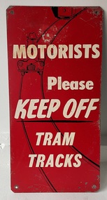 Melbourne Tram Museum
Sign - "Motorists Please Keep Off Tram Tracks"
Used by the MMTB in an attempt to keep tram tracks clear of motor cars. It seldom worked. Signs would have been fixed to the ends of a tram so it could be seen by motorists. See Item 6088 for another version.Demonstrates the methods the MMTB to ask motorists to keep tram tracks clear during the 1950's and 1960's.Sign - Zincalume steel sheet, with four holes in angled or trimmed corners asking "Motorists Please Keep Off Tram Tracks" Has the image of a motor car on the tram tracks with the outline of a tram following.tram stop, signs, mmtb, traffic control, trams, tramways -
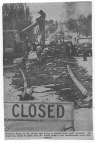 Ballarat Tramway Museum
Newspaper - Cutting - track removal Ballarat 1972, The Courier Ballarat
The newspaper cutting shows the nature of the track removal in Lydiard St North, Ballarat following closure of the SEC operated tramway system. Cutting not dated. Date based on an Tender advert on the rear, July 1972.Demonstrates the method of track removal, most likely by the Country Roads Board July 1972 Cutting from The Courier, Ballarat.Newspaper cutting - Cutting - track removal Ballarat 1972, Lydiard St North. track removal, lydiard st north, ballarat, tramways -
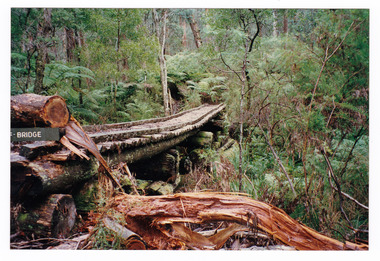
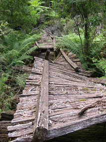 Marysville & District Historical Society
Photograph (item) - Colour photograph, 31-12-2008
A digital copy of a colour photograph of the timber tramway bridge along the Michaeldene Walking Track near Marysville in Victoria.A digital copy of a colour photograph of the timber tramway bridge along the Michaeldene Walking Track near Marysville in Victoria. The Michaeldene Trail to Taggerty River Lookout is a 4.3 kilometer lightly trafficked loop trail located near Marysville, Victoria. The track is one of several walking tracks located in and around Marysville in Victoria.timber tramway, michaeldene walking track, marysville, victoria, walking track -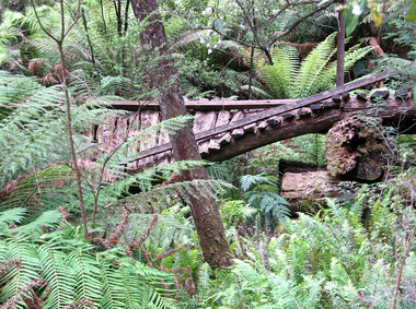
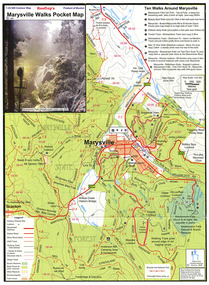 Marysville & District Historical Society
Map (Item) - Pocket map, Rooftop Mapping Services, Rooftop's Marysville Walks Pocket Map, 01-2009
A pocket map of ten walking tracks in an around Marysville. This map was published by Rooftop Mapping Services in January 2009.A pocket map of ten walking tracks in an around Marysville.marysville, victoria, australia, rooftop mapping services, steavenson falls, steavenson falls car park walk, beauty spot walk, marysville to el kanah guest house walk, gilberts gully walk, michaeldene track, man 'o' war walk, tree fern gully walk, marysville to woods lookout to mount gordon walk, keppels lookout walk -
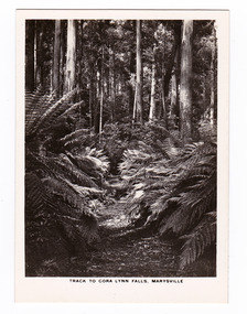
 Marysville & District Historical Society
Photograph (item) - Black and white photograph, Rose Stereograph Company, Track to Cora Lynn Falls, Marysville, 1913-1967
An early black and white photograph of the track to the Cora Lynn Falls in Marysville, Victoria.An early black and white photograph of the track to the Cora Lynn Falls in Marysville in Victoria. These falls are located on the Marysville-Wood's Point Road. Cambarville is notable for its giant mountain ash (Eucalyptus regnans) trees within the Cumberland Memorial Scenic Reserve, and relics from former sawmills and gold mining. The Big Culvert is located nearby on the Marysville - Woods Point Road, which was historically part of the Yarra Track. Cambarville was established as a timber mill town in the 1940s. Timber mill owners A Cameron and FJ Barton named Cambarville. They established the mill to salvage timber from trees destroyed in the 1939 bushfires. Cambarville was impacted by the 2009 Black Saturday bushfires and any remaining structures were destroyed. The photograph was also used to produce the Rose Series postcard P. 4958.marysville, victoria, photograph, cora lynn falls, waterfalls, p. 4958, rose series postcard, rose stereograph company, souvenir, cambarville, marysville-wood's point road, eucalyptus regnans, cumberland memorial scenic reserve, mining, big culvert, yarra track, a cameron, fj barton, 1939 bushfires, 2009 black saturday bushfires, timber mills -
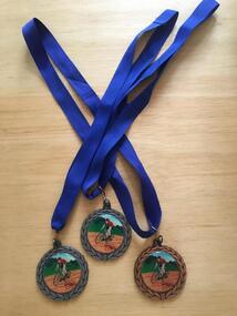 Geelong Cycling Club
Medals, 2002
Medals were presented by the Geelong West Cycling Club until the year 2002.Medals have always been given as recognition of achievement in competitive events.Medals in bronze and silver metal conglomerate. The front depicts an olive wreath around the circumference, and has a racing cyclist painted on an enamel disk in the centre. On the reverse side, inscription of the winner of the Women's Track Championships for 2002 appears inside an olive wreath decoration. "GWCC/Track Championships/Scratch Race/Women/Yolanda Russell/2002/Sprints/Time Trial"gwcc; track championships; scratch race; women; yolanda russell; 2002; sprints; time trial; -
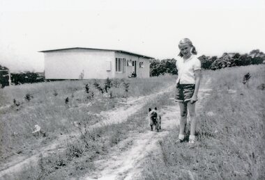 Park Orchards Community House
Photograph, 121 Arundel Road, Park Orchards property in summer 1958, Q4 1958
Catherine O'Connor with "Tinker". The dirt track is Arundel Road. The house is at (Lot 87) 121 Arundel Road, Park Orchards in Summer 1958. -
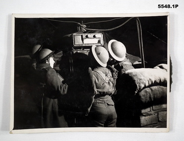 Bendigo Military Museum
Photograph
All photos of female British Army soldiers manning Air Defence Stations protecting Air Field from enemy attack using range finding equipment and predictors tracking incoming aircraft. Related to Beryl Scrimshaw (Morrel) of British Army. refer Cat No.304P & 315. All black and white photos of female British soldiers manning Air Defence Units. 1. Soldiers using prediction at night to track aircraft. 2. Soldiers in British Uniform at night using range finder to track aircraft. 3. Soldiers in British Uniform at night using range finder to track aircraft.On back - stamp of "Manchester Guardian & Evening News" Photo 1 also has description "Predictor". Photo 2 has description "Aircraft Spotter".aircraft defence, female soldiers, british army -
 Marysville & District Historical Society
Photograph (item) - Colour photograph, Pre 2009
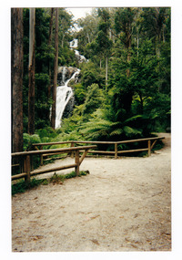
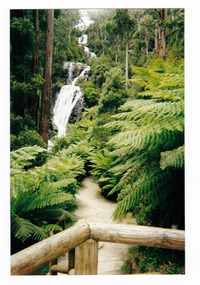
A colour photograph of the walking track leading to Steavenson Falls in Marysville in Victoria.A colour photograph of the walking track leading to Steavenson Falls in Marysville in Victoria. The Steavenson Falls is named after the Victorian Assistant Commissioner of Roads and Bridges, John Steavenson who arrived in Victoria in the early 1860s.Munroesteavenson falls, waterfalls, marysville, victoria, john steavenson -
 Marysville & District Historical Society
Photograph (item) - Colour photograph, Pre 2009
A colour photograph of the walking track leading to Steavenson Falls in Marysville in Victoria.A colour photograph of the walking track leading to Steavenson Falls in Marysville in Victoria. The Steavenson Falls is named after the Victorian Assistant Commissioner of Roads and Bridges, John Steavenson who arrived in Victoria in the early 1860s.Munroesteavenson falls, waterfalls, marysville, victoria, john steavenson -
 Phillip Island and District Historical Society Inc.
Photograph, ?
Part of collection of Photographs donated to the museum by the family of the late Mr. Jack Jenner. (1977).Sepia Postcard - View of a Bush RoadLabelled "Typical Road, Phillip Island".local history, photography, photographs, slides, film, view cowes, sepia photograph, jack jenner, road, cowes, phillip island -
 Ringwood and District Historical Society
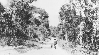
Photograph, Deep Creek Road in the early days (undated)
Narrow Dirt Road, with you man and dog standing in road. No date.Typed below photograph, "Deep Creek Road in the early days". -
 Whitehorse Historical Society Inc.
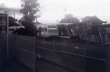
Photograph, Nunawading Station looking from the north side, 1/06/2009
One of a collection of photographs taken of the Nunawading Railway Station prior to the lowering of the railway line and building of the new railway station on the western side of Springvale Road so that the Springvale Road Rail Crossing can be eliminated.Black & white photograph of he precinct surrounding the Nunawading Station and the Springvale Road Railway crossing. This photograph is the station looking from the entrance of station on the north side of the tracks. See NP 3545 to NP3567 for the complete set of photographsnunawading railway station, springvale road nunawading, redevelopment of railway line/springvale road. -
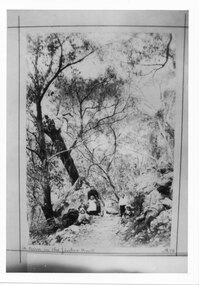
 Marysville & District Historical Society
Photograph (item) - Black and white photograph, Rose Stereograph Company, Track to Cora Lynn Falls, Marysville, 1913-1967
An early black and white photograph of the track to the Cora Lynn Falls near Marysville, Victoria.An early black and white photograph of the track to the Cora Lynn Falls near Marysville in Victoria. These falls are located on the Marysville-Wood's Point Road. Cambarville is notable for its giant mountain ash (Eucalyptus regnans) trees within the Cumberland Memorial Scenic Reserve, and relics from former sawmills and gold mining. The Big Culvert is located nearby on the Marysville - Woods Point Road, which was historically part of the Yarra Track. Cambarville was established as a timber mill town in the 1940s. Timber mill owners A Cameron and FJ Barton named Cambarville. They established the mill to salvage timber from trees destroyed in the 1939 bushfires. Cambarville was impacted by the 2009 Black Saturday bushfires and any remaining structures were destroyed. The photograph was also used to produce the Rose Series postcard P. 4958.marysville, victoria, photograph, cora lynn falls, waterfalls, p. 4958, rose series postcard, rose stereograph company, souvenir, cambarville, marysville-wood's point road, eucalyptus regnans, cumberland memorial scenic reserve, mining, big culvert, yarra track, a cameron, fj barton, 1939 bushfires, 2009 black saturday bushfires, timber mills -
 Marysville & District Historical Society
Photograph (Item) - Black and white photograph, The "Scandinavians' - (Deserted), c1900
An early black and white photograph of The Scandinavian's Hotel and Boarding House along the Yarra Track.An early black and white photograph of The Scandinavian's Hotel and Boarding House along the Yarra Track. The Yarra Track is the former name of the gold fields road from Healesville to the Woods Point and Jordan Goldfields, in Victoria, Australia. A direct route via the Yarra River and the Great Divide was discovered by Rieck in September 1862 and became known as the Yarra Track. Early in 1863, the Victorian Government decided to construct a 193-kilometre (120 mile) road along the route. Its original width varied between 4 and 6 metres (12 and 20 feet), and was designed to accommodate horse-drawn vehicles. The Track involved the climbing of the Black Spur, descent into the Acheron Valley, and then through Marysville to the Cumberland where it followed the existing route.ARMSTRONG COLLECTION 42 STATION STREET/ SANDRINGHAM 3191/ TEL. (03) 9521 5442/ IAN M.L. ARMSTRONG OAMthe scandinavians', yarra track, healesville, wood's point, jordan goldfields, victoria, yarra river, great divide, reick, black spur, acheron valley, marysville, cumberland creek -
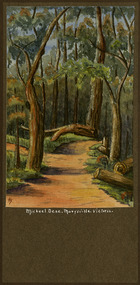 Marysville & District Historical Society
Painting (Item) - Watercolour painting, Miss I.K. Higgins, Michael Dene, Marysvile, Victoria, c1920
A watercolour painting of the Michael Dene walking track in Marysville in Victoria.A watercolour painting of the Michael Dene walking track in Marysville in Victoria by a Miss I.K. Higgins of Geelong in 1920. The Michaeldene Trail to Taggerty River Lookout is a 4.3 kilometer lightly trafficked loop trail located near Marysville, Victoria. The track is one of several walking tracks located in and around Marysville in Victoria.Michael.Dene.Marysville.Victoria Donated / by/ Elsie Stephens/ Mornington Painted by/ Miss I.K. Higgins/ of Geelong/ cc. 1920michael dene walking track, marysville, victoria, i.k. higgins, taggerty river -
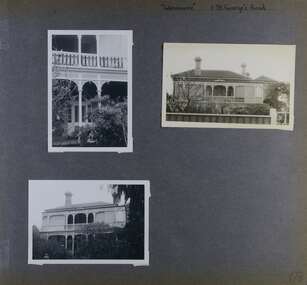 Glen Eira Historical Society
Album - Album page, Glenmoore, St George's Road, Circa 1972
This photograph is part of the Caulfield Historical Album 1972. This album was created in approximately 1972 as part of a project by the Caulfield Historical Society to assist in identifying buildings worthy of preservation. The album is related to a Survey the Caulfield Historical Society developed in collaboration with the National Trust of Australia (Victoria) and Caulfield City Council to identify historic buildings within the City of Caulfield that warranted the protection of a National Trust Classification. Principal photographer thought to be Trevor Hart, member of Caulfield Historical Society. Most photographs were taken between 1966-1972 with a small number of photographs being older and from unknown sources. All photographs are black and white except where stated, with 386 photographs over 198 pages. From Victorian Heritage Database citation for HO59 Glenmoore, 1 St Georges Road Elsternwick https://vhd.heritagecouncil.vic.gov.au/places/35202 as at 30/10/2020 "Glenmoore" is locally significant as a surviving mid nineteenth century villa residence in the then fashionable bi-chromatic brick form. It is also important as the home of Hugh Moore who built several shops in nearby Glen Huntly Road and which remain as important contributors to the architectural character of the Elsternwick Shopping Centre.Victorian Heritage Database citation HO59 Glenmoore, 1 St Georges Road Elsternwick https://vhd.heritagecouncil.vic.gov.au/places/35202 An imposing two storeyed villa in bichrome brick with two storeyed timber posted verandah, coupled with cast iron lace frieze, spandrels and central tympanum enrichment. The hipped roof is in slate and has a prominent crean1 brick chimney stack forming part of the facade. Openings are flat arched although the entrance is round arched with a fan light. The south elevation has bayed windows. Two storeyed hip roofed additions are sympathetic and attached on the north side and at the rear. Inside, the staircase and stained glasswork with initials "HM" and family coat of arms are important surviving elements. INTEGRITY: Good, timber outbuildings of an early date, mature and spacious front garden includes early palm trees. Alterations include reconstruction of facade verandah including tiled pavement and front door on east side. Interior has a high level of integrity. Original grounds included adjoining "Carramar".Page 178 of Photograph Album with three photographs of Glenmoore, St Georges Road. Handwritten: "Glenmoore" 1 St George's Road [top right] / 178 [bottom right]trevor hart, chimneys, porch, mansion, slate roof, return verandah, stained glass, cast iron frieze, glenmoore, 1860's, hugh moore, glenmoore estate, double storey, elsternwick shops, st george's road, thomas watts, elsternwick, victorian style, protruding bay windows, cast iron work, bi-chromatic bricks, gardens, balconies, moore's buildings, glen huntly road, stairs, house names -
 Kew Historical Society Inc
Photograph - Railway level crossing in Glenferrie Road, Glenferrie, E.J. Dower, c.1912
One of a series of photographs, taken by Edgar James Dower in the second decade of the twentieth century. Born and raised in Olinda, his family later moved to Surrey Hills. He worked as an adult as a clerk in the city office of the Metropolitan Gas Company, and in his role as a 'collector', he was able to photograph scenes including the construction of tramlines and associated buildings in Kew, Hawthorn, Camberwell and Surrey Hills. Later he established a real estate agency with his brother - the E.J. Dower Real Estate Agency, Dandenong Office.The image is an historically significant record of the development of transport infrastructure which was used to connect Victorians in the first two decades of the twentieth century. This development resulted from increases in population and the consequent extension of Melbourne's suburbs. The photographs, both individually and collectively, richly detail the labour of workers and the tools and machinery used to create and extend Melbourne's public transport network in the years preceding and during World War 1.Digital copy of an original mounted photograph showing Glenferrie Road Hawthorn, looking north towards the old railway level crossing that existed before the line was elevated on a bridge over Glenferrie Road. "The Don Store" at right is immediately behind the old railway level crossing. The tree and shops at left before the crossing were to be removed / demolished as part of the realignment of the train tracks.Annotated verso: "1914 [deleted]/1913 / Glenferrie Road showing railway gates / Taken just before the commencement of the regrading of railway line to Camberwell".theme --- travelling by tram, theme -- connecting victorians by transport and communications, glenferrie road -- hawthorn (vic.), railways -- hawthorn, the don store -- hawthorn (vic.) -
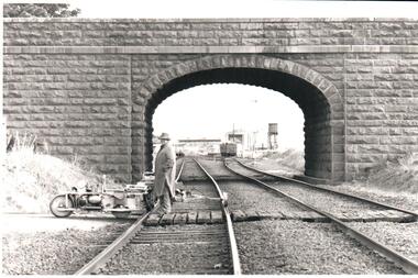 Hume City Civic Collection
Photograph, Pre 1989
The bluestone 'road over rail' bridge at Macedon Street is of state architectural, architectural, historical and engineering significance. It spans the first government regional railway. Its design and building was done according to strict English standards and made use of a bridge crossing instead of a level road crossing.A black and white photograph of a stone bridge with an eliptical arch spanning two rail tracks. A workman is standing between one set of tracks in the foreground and a railcart is next to the tracks. The station, footbridge and water tower are visible through the arch.road over rail bridge, bridges, sunbury railway station, water towers, pedestrian bridges, stone bridges, george evans collection -
 Halls Gap & Grampians Historical Society
Photograph - B/W, C 1898
The picture shows Maggie Galbraith and five small children (identities unknown) beside a jinker track (bridal path) near Halls Gap.A woman and five small children, two boys and three girls, on a dirt track with trees and rocks on either side of it.access routes, jinker track, people, galbraith -
 Orbost & District Historical Society
folder, Orbost Bridges - Snowy River Road Bridges, 1974 1976
This folder was compiled in October 2015 from documents, magazines. papers and photographs donated by David Jellie, engineer in charge 1974 - 1976. In early 1974, as an Engineer with the Country Roads Board, David came to Orbost as the Supervising Engineer for the construction of the new bridges which were part of an 8.4km Orbost bypass road design. This was a major project involving not only a new bridge over the Snowy River (including Lochiel Lagoon), but other bridges over Ashby’s Gulch and Watt’s Gulch. These new bridges were opened in November 1976 with the unveiling of a plaque on the eastern end of the $2.4M Snowy River Bridge. (ref. May Leatch)This item is a useful reference tool on the construction history of the Snowy River Road bridges.A white plastic folder - Orbost Bridges - Snowy River Road Bridges. it contains newspaper articles, booklets, photographs and documents relating to the construction of the Snowy River Road Bridge in 1974 -1976.on front cover - 1974 - 76 ORBOST / SNOWY RIVER ROAD BRIDGES * construction * photos * articles * plans Donated by David Jellie Oct 2015snowy-river-bridges jellie-david -
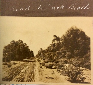 Phillip Island and District Historical Society Inc.
Photograph, Road to the Back Beach, 1925-1926
Sepia photograph of an rough, sandy, unmade road with trees and bushes along the side.Road to the Back Beachphotographs, phillip island early roads -
 Ballarat Tramway Museum
Photograph - Black and White W4 671 St Kilda Road, Charles Craig
Photograph shows Ballarat Tramway Museum tram W4 671 (St Kilda Beach, route 15) in St Kilda Road at High Street during the late 1950s or early 1960s It has a "Mr Motorist keep my tracks clear" sign on the rear. A number of sun shades have been lifted.Yields information about W4 class trams.Photograph - Black and White W4 671 St Kilda Roadtramways, trams, w4 class, tram 671, st kilda road -
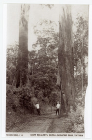 Mt Dandenong & District Historical Society Inc.
Photograph, Giant Eucalypts, Olinda-Sassafras Road. Victoria
Rose Series post card # P.69 .The Sassafras - Olinda Road showing giant Eucalypts. The two men in the photograph most probably worked for The Rose Series Post card company. They often appear in photographs - probably to give perspective.Copy of Rose Series post card P. 69 showing two men standing alongside giant trees on the Olinda-Sassafras Road.On front: THE ROSE SERIES P. 69 GIANT EUCALYPTS, OLINDA-SASSAFRAS ROAD, VICTORIA.sassafras, olinda, sassafras-olinda road, olinda-sassafras road, rose series, post cards, eucalypts, road -
 Marysville & District Historical Society
Photograph (item) - Colour photograph, 1996
A colour photograph of the timber tramway bridge along the Michaeldene Walking Track near Marysville in Victoria.A colour photograph of the timber tramway bridge along the Michaeldene Walking Track near Marysville in Victoria. The Michaeldene Trail to Taggerty River Lookout is a 4.3 kilometer lightly trafficked loop trail located near Marysville, Victoria. The track is one of several walking tracks located in and around Marysville in Victoria.1996timber tramway, michaeldene walking track, marysville, victoria, walking track -
 Melbourne Tram Museum
Photograph - Cable tram track demolition - Nicholson St Fitzroy, 1954/55
Photograph shows cable tram track being removed in Nicholson St to the north of Gertrude St. The cable tram engine house can be seen in the far distance. Photographer and date unknown - 1954/55.Yields information about the removal of cable tram tracks in Nicholson Fitzroy during 1954/55.Black and white photograph with notes on rearOn rear in pencil number "141" in pencil in top right hand corner and "Removing cable track ? St?".tramways, cable trams, nicholson st, trackwork, demolition