Showing 14941 items
matching view-finder
-
 Eltham District Historical Society Inc
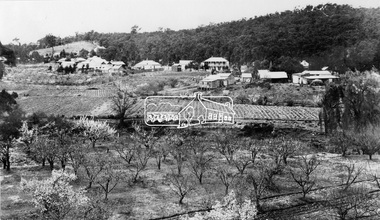
Photograph, View at Hurstbridge, 1924
View of Hurstbridge township overlooking fruit trees in flower in the foregaround and ploughed paddocks ready for crop planting in the middle of the photo.This photo forms part of a collection of photographs gathered by the Shire of Eltham for their centenary project book, "Pioneers and Painters: 100 years of the Shire of Eltham" by Alan Marshall (1971). The collection of over 500 images is held in partnership between Eltham District Historical Society and Yarra Plenty Regional Library (Eltham Library) and is now formally known as The Shire of Eltham Pioneers Photograph Collection.' It is significant in being the first community sourced collection representing the places and people of the Shire's first one hundred years.Digital imagesepp, shire of eltham pioneers photograph collection, hurstbridge, orchard, fruit trees -
 Mt Dandenong & District Historical Society Inc.
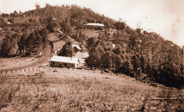
Photograph, 1920s view of Kalorama FiveWays, c1920
North view Mountjoy complex, Post Office and Store at FiveWays. Mountjoy Guest-house on hll with Jeeves Coach Service.Black and white photograph looking up hill towards guest house with two smaller buildings clearly visible in foreground and several roof tops in distance.ellis jeeves, fiveways, guest house, jeeves, mountjoy, post office, coach service -
 Federation University Historical Collection
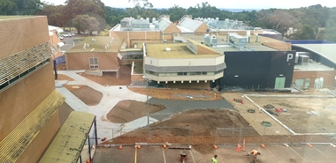
Photograph, Clare Gervasoni, View to the West Overlooking P Building, 2020, 16/04/2020
View to the West Overlooking P Building showing the garden and carpark area under redevelopment. The Photo was taken from the Geoffrey Blainey Research Centre on the top floor of the E.J. Barker Library.mount helen campus, p building, garden redevelopment -
 Port Melbourne Historical & Preservation Society
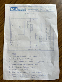
Document, MM Crane Factory - Plan View, 18 Feb 2020
Blue printed plan view of Malcolm Moore Crane Factory with lettered index of areas within the factory from 1979 some with names listed including Norm (presumably Norm Robinson).built environment - industrial, industry, engineering, malcolm moore pty ltd, norm robinson -
 Whitehorse Historical Society Inc.
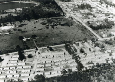
Photograph, Aerial View - Eastbridge Hostel, 1953
Black and white Aerial View of Eastbridge Migrant Hostel in Rooks Road, Nunawading (since demolished) taken in 1953. Donor's Family was first Family in Eastbridge and Donor was Housekeeper there for 2 years.jones, mrs, eastbridge migrant hostel -
 Mt Dandenong & District Historical Society Inc.
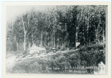
Photograph, Side View Mr G. Barber Homestead Mt Dandenong, c1905
Built in 1898 by early settler George Barber the property is still in existence today. It was the home of George, wife Sarah Ann and daughter Ethel.Black and white photograph showing te side view of George Barber's home, later named Forest Edge. c1905. Reverse of photograph has handwritten description by John Lundy-Clarke.Barber's home on Olinda Creek. Lot 25 Sect 1 Village Settlement. Home of George Barber and wife Sarah Ann (nee Richardson). Daughter Ethel.Was bought by Munnerley later Sangster and Kinnear. Later known as Forest Edge. Buggy and wagon shed on right. Photo copied 1973 by JLC. -
 Mt Dandenong & District Historical Society Inc.
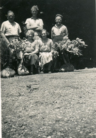
Photograph, Workers at Range View Nursery, 1950s
Iris and Ted Woolrich pose with a group at Range View Nursery in the 1950s. Bagged rhododendrons at the front. L to R: John Jaggers, Henk Koelwyn, Ted Woolrich, Iris Woolrich & Alice.Handwritten on the reverse in pencil: John Jaggers, Henk, Ted, Alice & Irisiris woolrich, ted woolrich, range view nursery, henk koelwyn, john jaggers, olinda, rhododendron -
 University of Melbourne, Burnley Campus Archives
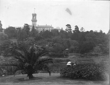
Photograph - Black and white print, View of Botanic Gardens, Unknown
Black and white print. View across the lake to Government House, 2 young children seated in the foreground. Photographs B91.409 to B91.417 appear to have come from the same photograph album.lake, government house, royal botanic gardens, botanic gardens, view -
 Whitehorse Historical Society Inc.
Photograph - Aerial Photograph, Aerial View of Australian Tesselated Tile Co. Pty. Ltd. & others, 1935
An aerial view of Australian Tessellated Tile Works. |In the background M & MBW reservoir. In the foreground is the Builders Trading and Roofing Company Tile works (formerly the Monarch Pottery - note the M on the chimney)australian tesselated tile co.pty ltd, aerial photographs, dams and reservoirs, mitcham reservoir, builders trading and roofing co. ltd, monarch pottery -
 Ringwood and District Historical Society
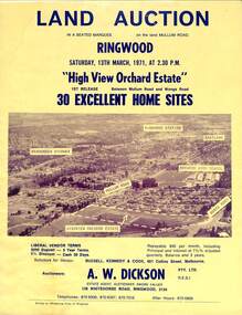
Flyer, Land Auction Sale Brochure, High View Orchard Estate, Ringwood, Vic. - 1971
Double-sided advertisement for Ringwood High View Orchard Estate land auction sale on Saturday, 13th March, 1971, including aerial photograph, map, and summary of local facilities and services.Subdivision includes Wonga Road, Oban Road, Sang Court, Ambrie Avenue, Hendra Grove, and Mullum Mullum Road. Agent - A.W. Dickson Pty. Ltd., 136 Whitehorse Road, Ringwood, 3134. Telephones: 870 6000, 870 6007, 870 7016, after hours 870 6868. A separate copy of the advertisement includes a local newspaper follow-up clipping reports thirty home sites grossing $102,350 at the auction. -
 Bendigo Historical Society Inc.
Film - CAMERA
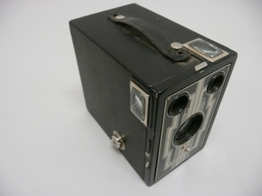
Brownie Six-16 camera by Eastman Kodak Company, black box camera with vinyl covering, assorted view finders & lenses.Made in Canada by Canadian Kodak Co Limited Toronto Ont.photography, cameras-still, brownie -
 Eltham District Historical Society Inc
Work on paper (Sub-Item) - Photograph, Research Creek. View to the culvert under the Eltham-Hurstbridge railway line from the Coolabah Drive culvert
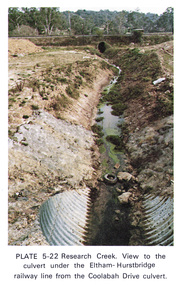
Colour photograph of Research Creek. View to the culvert under the Eltham-Hurstbridge railway line from the Coolabah Drive culvert, Elthameltham, research creek, coolabah drive, culvert, eltham hurstbridge railway, drain -
 Greensborough Historical Society
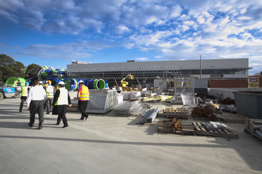
Photograph - Digital image, Watermarc under construction: Outside view of worksite, 18/05/2012
Outside view of worksite. The redevelopment of the Greensborough Pool into the Watermarc aquatic centre is documented in this collection of photographs from the collection of Rosie Bray. These photographs taken on a ‘Community Consultative Committee’ walk through prior to completion of Watermarc, May 18 2012.Digital copy of colour photograph.watermarc, greensborough pool, swimming pools, rosalie bray -
 Greensborough Historical Society
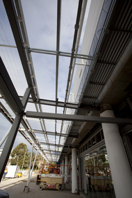
Photograph - Digital image, Watermarc under construction: View of trusses and beams, 18/05/2012
View of trusses and beams. The redevelopment of the Greensborough Pool into the Watermarc aquatic centre is documented in this collection of photographs from the collection of Rosie Bray. These photographs taken on a ‘Community Consultative Committee’ walkthrough prior to completion of Watermarc, May 18 2012.Digital copy of colour photograph.watermarc, rosalie bray, greensborough swimming pool, swimming pools -
 Stawell Historical Society Inc
Photograph, Pleasant Creek Training Centre -- Aerial View
Framed Aerial view of Pleasant Creek Training Centre Referred to as Pleasant Creek Training Centre or Pleasant Creek Special Schoolstawell -
 City of Ballarat Libraries
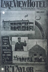
Photograph - Card Box Photographs, Advertisement for Lake View Hotel 1916. From Citizens & Sports publication
The Lake View Hotel is located on Wendouree Parade. The proprietor was R. Taylor. The advertisement also shows the hire of sailing and rowing boats. lake view hotel, wendouree parade, r. taylor, advertising, boatshed, vehicle, boats, ballarat -
 Stawell Historical Society Inc
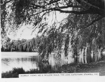
Photograph, Murray Views, "Willow Walk" at the Lake in Cato Park Stawell c1950 -- Postcard, C 1950
Sister of Donor Visited Stawell in th e1950'2 When she Purchased thes Murray Views Cards. The Cards were produced for sale to touristsSet of 8 Murry Views Postcards No 1 to No 8 C. 1950Murray Views No 6 Willow Walk The Lake Cato Park Stawell -
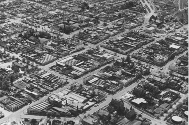
 Federation University Historical Collection
Photograph - Photograph - Black and White, Aerial View of Federation University SMB Campus, c1967
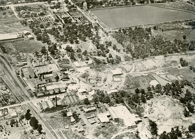
This photograph was taken around the time that the Ballarat School of Mines obtained the Former Ballarat Gaol site and the Ballarat Brewery site.Black and white photograph showing an aerial View of Federation University SMB Campus. The image shows the former Ballarat Gaol (now demolished), Ballarat Brewery, (now demolished) and White Flat Oval.ballarat school of mines, ballarat gaol, ballarat brewery, white flat, ballarat townscape, smb campus, ballarat school of mines campus, lydiard street, aerial -
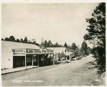 Mt Dandenong & District Historical Society Inc.
Photograph, Street View, Olinda, late 1930s
Number 1 in commercial series.Small photograph, number 1 in Olinda series, showing a view of the Main Street of Olinda late 1930s. V.J. Boulter's Olinda General Store with butcher and bakery in foreground. Road not yet made.boulter, v.j. boulter, general store, butcher, bakery, olinda -
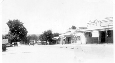 Linton and District Historical Society Inc
Photograph, Sussex Street, Linton - view to north, late 1920s or early 1930s
Dated to late 1920s or early 1930s as Nelson building has been renovated as a Californian bungalow. The earlier curvilinear parapet on the library building (see photo - Registration no. 166) has been squared off, and a small pedimented timber parapet has been added above.Black and white photograph of Linton's main street, Sussex Street. View of Railway Hotel, Nelson undertaker building, public library and "cash emporium". Cars parked and driving along Sussex St."Linton Main Street".sussex street linton, railway hotel, nelson undertakers, linton public library, cash emporium, transport, cars -
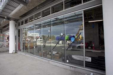
![Photograph - Digital image, Watermarc under construction: View of building exterior [worksite], 18/05/2012](/media/collectors/4f729f5697f83e03086015b8/items/54c878a72163100b58415a84/item-media/54c878dc2163100b58419536/item-fit-380x285.jpg) Greensborough Historical Society
Greensborough Historical SocietyPhotograph - Digital image, Watermarc under construction: View of building exterior [worksite], 18/05/2012
View of building exterior [worksite]. The redevelopment of the Greensborough Pool into the Watermarc aquatic centre is documented in this collection of photographs from the collection of Rosie Bray. These photographs taken on a ‘Community Consultative Committee’ walkthrough prior to completion of Watermarc, May 18 2012.Digital copy of colour photograph.watermarc, rosalie bray, greensborough swimming pool, swimming pools -
 Greensborough Historical Society
Photograph - Digital image, Watermarc under construction: View of windows with reflection of waterslide, 18/05/2012
View of windows with reflection of waterslide. The redevelopment of the Greensborough Pool into the Watermarc aquatic centre is documented in this collection of photographs from the collection of Rosie Bray. These photographs taken on a ‘Community Consultative Committee’ walkthrough prior to completion of Watermarc, May 18 2012.Digital copy of colour photograph.watermarc, rosalie bray, greensborough swimming pool, swimming pools -
 Greensborough Historical Society
Photograph - Digital image, View of Bicton Street from Gladstone Road, 1950_
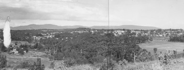
This view of Bicton Street Greensborough, taken from Gladstone Road Briar Hill circa 1950 shows the rural nature of the suburb at this time.Digital copy of black and white photo.bicton street greensborough, gladstone road briar hill -
 Glenelg Shire Council Cultural Collection
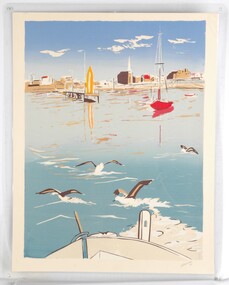
Print, View From A Boat, 1984
Laminated screenprint of Portland harbour from the perspective of a boat looking back towards the shore. In the foreground is the front of the boat and four birds about to take flight from the water. The background features a few boats and the buildings along Bentinck Street. -
 Greensborough Historical Society
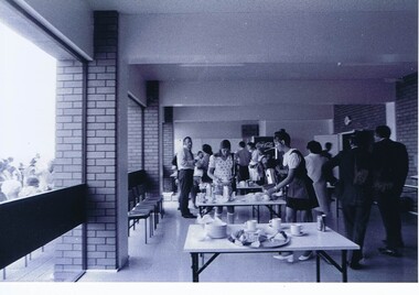
Photograph - Photograph - Digital Image, Opening of Shire of Diamond Valley offices 1972: Interior view of refreshments being served, 26/02/1972
The official opening of the Shire of Diamond Valley offices in Greensborough on 26/02/1972. This photograph shows an interior view of refreshments being served.Photographs taken by a member of SDV staff.Photographs from of a folder of 21 colour photographsOn cover of folder "Opening of S.D.V. Office"shire of diamond valley, shire of diamond valley offices 1972 -
 Ringwood and District Historical Society
Photographs, 1979-80 MMBW pipe line project at Hubbard Reserve, North Ringwood � View towards Debbie Place
Part of a 43-photo record of the MMBW�s engineering feat in drilling a 12 inch pipe line up to 40 feet deep through rock hardened by volcanic action associated with geological fault that occurs along the line. The work took place from October 1979 to May 1980 on the southern boundary of Hubbard Reserve, North Ringwood. The collection was presented to the Ringwood Historical Research Group by J Clarke on 9th June 1980.E561 N15 3 March 1980 A43 View towards Debbie Place, showing 2 swivel cranes at shafts, timber of manhole in creek, the tracked drill rig and its compressor caravan. -
 Ringwood and District Historical Society
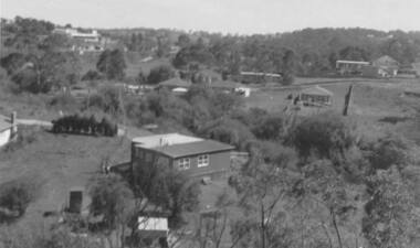
Photograph, Panoramic view of Ringwood taken from the home of Dr. Geoffrey A. Cook, Loughnan Rd., Ringwood. (No date)
Written on back of photograph, "Panoramic view of Ringwood taken from the home of Dr. Geoffrey A. Cook, Loughnan Rd., Ringwood. See booklet, 'Welcome to Ringwood' 1948 or 49' - H.J. Pearson Mayor". -
 Eltham District Historical Society Inc
Photograph, Peter Pidgeon, View from Bolton Street, Eltham, 2 Aug. 2022
View looking east from Bolton Street near Brougham Street, Eltham taken from PETStock looking over the industrial area of ElthamBorn Digitaleltham, bolton steet, industry, petstock eltham central, little eltham -
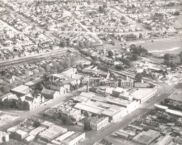
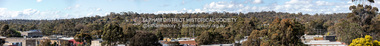
 City of Ballarat Libraries
Photograph, Aerial View of the Ballarat CBD in 1957 / 1958
This aerial view of the Ballarat CBC was taken sometime in 1957 or 1958. Sturt Street can be seen running from the right centre to top left.aerial view, sturt street, ballarat, central business district, cbd -
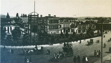 City of Ballarat Libraries
Photograph, View the Unicorn Hotel of Sturt and Camp Streets
The State Bank and Library buildings and telegraph can be seen. This sketch comes from from the Premier Album of Ballarat Views circa 1870-1880.unicorn hotel, state bank, library, building, streetscape, ballarat, telegraph, premier album of ballarat views