Showing 1122 items
matching waterway
-
 Lakes Entrance Historical Society
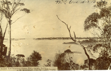
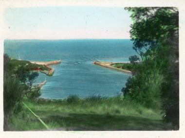
Postcard - The Entrance
Black and white post card showing the man made entrance through the hummock. It shows the fishermen's cottages on the western side of the entrance, Rigby Island and the Doughboy, small island, with salt affected vegetation and a small sand bar in the channel. Natural vegetation of Kalimna cliff in foreground. Lakes Entrance VictoriaLakes Entrance from Kalimna Hotel waterways, topography -
 Lakes Entrance Historical Society
Photograph - The Entrance, Calvert Barbara, 1960c
Black and white photograph of the man-made entrance from Bass Strait to the Gippsland Lakes taken from Jemmys Point. It also shows the rock groynes at Bullock Island with dredged sand starting to fill the basins to enlarge the island. Lakes Entrance Victoriawaterways, public works -
 Lakes Entrance Historical Society
Photograph - The Entrance, 1945c
Other copiesHand tinted colour photograph of the man-made entrance from Bass Strait to the Gippsland lakes, taken from Jemmys Point. It also shows the rock groynes at the western end of Bullock Island, and at the entrances to Cunninghame Arm and the North Arm. Lakes Entrance VictoriaThe Entrance, Lakes Entranceislands, waterways, boats and boating -
 Lakes Entrance Historical Society
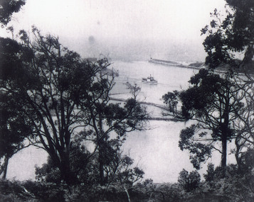
Photograph - The Entrance, 1920c
Black and white photograph of the man-made entrance from Bass Strait to the Gippsland Lakes, taken from the road at Jemmys Point. It also shows the rock groynes at Bullock Island. A steamer is entering the lakes from Cunninghame Arm. Lakes Entrance Victoriawaterways, ships and shipping -
 Lakes Entrance Historical Society
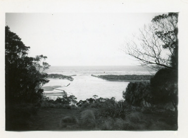
Postcard - The Entrance, 1940
Hand tinted small format postcard of the man-made entrance from Bass Strait to the Gippsland Lakes taken from Jemmys Point. It also shows the rock groynes at the entrance to Cunninghame Arm, and the grassy clearing atop Jemmys Point in the foreground. Lakes Entrance Victoriaislands, topography, waterways -
 Lakes Entrance Historical Society
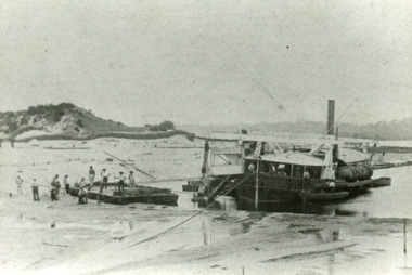
Photograph - Wombat, 1885c
The dredge 'Wombat' owned by John Carpenter, contractor for stage one of cutting the entrance from the lake through to ocean - Bass Strait. Photo shows channel partly dredged and men on work platform in front of dredge.Black and white photograph showing bucket dredge Wombat removing sand from between piers. Dunes on western side on left, lakes in background, hills of Kalimna and Nungurner in distance. Work platform in front of dredge with workers. Lakes Entrance Victoria waterways, public works, dredging -
 Lakes Entrance Historical Society
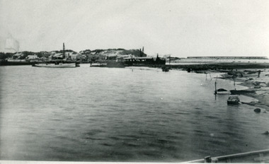
Photograph - The Entrance, 1885c
Also two identical copies|Also one 9 x 13 potograph in spares boxBlack and white photograph showing building of the entrance piers. Works building and houses on dunes at left, partially built pier on right background. Wombat dredge in centre. Lakes Entrance Victoriajetties, waterways, public works, historic buildings -
 Lakes Entrance Historical Society
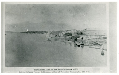
Photograph - Reeves River
Black and white photograph showing building, boats, and workmen at site of proposed New Entrance. View of Reeves River, later called Cunninghame Arm, looking east towards natural entrance. Lakes Entrance VictoriaReeves River from the New Lakes Entrance 1885c waterways, public works -
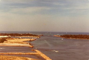 Lakes Entrance Historical Society
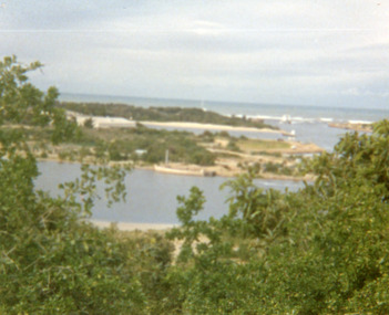
Photograph - The Entrance, Holding George, 1979
Date made April 1979Colour photograph of the Entrance, Bullock Island and Reeves Channel, taken from Jemmys Point during the King of the Straits, offshore powerboat race. It also shows the built up groynes at the entrance to the North Arm, Pecks fish processing factory seen on Bullock Island. Lakes Entrance Victoriawaterways, recreation, boats and boating -
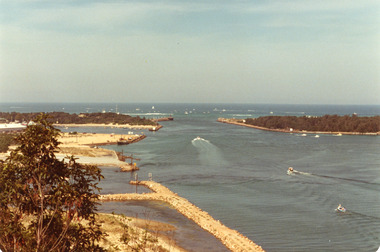 Lakes Entrance Historical Society
Photograph - The Entrance, 1979
The king of the straits, offshore powerboat race with Lakes entrance as a destination was not repeated due to adverse weather conditionsColour photograph of the entrance, Bullock Island and Reeves Channel. Taken from Jemmys Point during the King of the Strait offshore powerboat race. It also shows the built up groynes at the entrance to the North Arm. Lakes Entrance Victoriafishing industry, waterways, boats and boating -
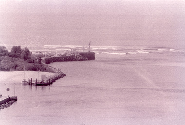 Lakes Entrance Historical Society
Photograph - The Entrance, Fish Marie, 1995
Black and white photograph of the Eastern Pier, taken from Jemmys Point. It shows the rock wall of the pier, rock groynes at the entrance to Cunninghame Arm behind which dredged sand has been dumped. Lakes Entrance Victoria waterways, piers -
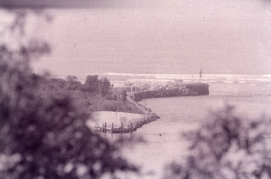 Lakes Entrance Historical Society
Photograph - The Entrance, Fish Marie, 1995
Black and white photograph of the eastern rock wall of the entrance to Bass Strait from the Gippsland Lakes, at Lakes Entrance, Victoria. waterways, boats and boating -
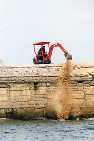 Lakes Entrance Historical Society
Photograph, Lakes Post Newspaper, 1999c
Colour photograph showing workman using digging machine to remove sand from inside entrance pier at Lakes Entrance Victoria.waterways, jetties, machinery, public works -
 Lakes Entrance Historical Society
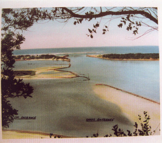
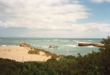
Photograph - The Entrance, 1995c
Colour photograph showing the entrance to the Gippsland Lakes from the ocean, Bass Strait, with fishing boat crossing the entrance, the ocean breaking on the bar outside. Lakes Entrance Victoriawaterways, ships and shipping -
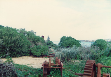 Lakes Entrance Historical Society
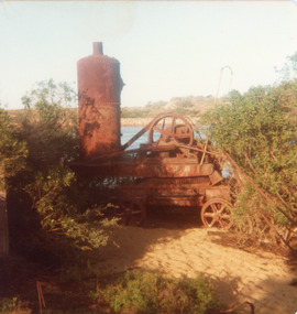
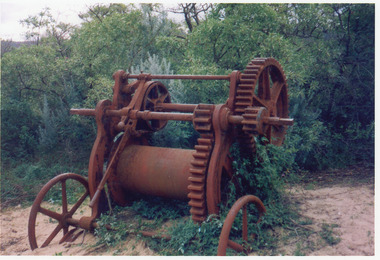
Photograph - Historic Site, Fish, Marie, 2000c
Also three views of old machinery.Colour photograph showing rusted remains of the travelling crane at the entrance Lakes Entrance Victoria islands, waterways, machinery -
 Lakes Entrance Historical Society
Photograph - Historic Site, Fish, Marie, 2000c
Also three views of old machinery.Colour photograph showing rusted remains of the travelling crane at the entrance Lakes Entrance Victoria islands, waterways, machinery -
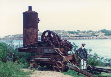
 Lakes Entrance Historical Society
Photograph - Historic Site, Goff, Russell, 1989c
Small format photograph showing rusted travelling crane at entrance piers. Steam boiler still attached. Lakes Entrance Victoria vegetation, waterways, machinery -
 Lakes Entrance Historical Society
Photograph - Natural Entrance, 1880c
Taking the Bar, 1876 woodcut of original entrance, with paddle steamer 'Lady of the Lake' and pilot boat grinding through rough conditions, can see Roadknight's Jetty, they lived at Merrangbaur, is aboriginal for home of lyrebirds.Colour photograph of a painting of a ship being towed over the natural entrance to the Gippsland Lakes. Red Bluff in background, Roadknight Jetty glimpsed through the natural vegetation. Lakes Entrance VictoriaTaking the Bar from Roadknights Jettyships and shipping, jetties, waterways -
 Lakes Entrance Historical Society
Photograph - Dredging, Bennett, Vera, 1989
Date made July 1989Colour photograph showing the entrance, lakes and Lady Harriets barge moored beside Bullock Island. Fishing boat coming through the entrance. Lakes Entrance Victoria waterways, islands, dredges -
 Lakes Entrance Historical Society
Photograph - New Works Jetty, Fraser, Nancy, 1983c
from Nan Fraser's albumColour photograph of old New Works Jetty and shed during demolition at Lakes Entrance, Victoria. waterways, jetties -
 Lakes Entrance Historical Society
Photograph - Historic Site, 1990c
Colour photograph showing rusted remains of the grab winch. Part of the overhead gantry system designed to lift huge precast concrete blocks in construction of piers. Lakes Entrance Victoria waterways, public works, machinery -
 Lakes Entrance Historical Society
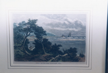
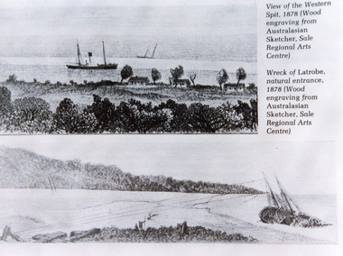
Photograph - Natural Entrance
Black and white photographic postcard of an illustrative collage of two wood engravings, one showing view of the Western Spit of the natural entrance, with a steamer anchored and three cottages on the bank. The second illustration shows the wreck of the trading schooner Latrobe, at the natural entrance. Lakes Entrance VictoriaView of the Western Spit, 1878 (Wood engraving form Australasian Sketcher, Sale Regional arts Centre)waterways, ships and shipping -
 Lakes Entrance Historical Society
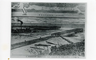
Photograph - Entrance Works, 1880c
Photographic reproduction of woodcut drawing of the building of the entrance and map above of location.Black and white photograph of a woodcut showing dredge working between timber constructed piers on entrance from the lakes to the ocean Bass Strait. Piers unfinished, timber lying around, sand in the entrance. Map above showing position of the lakes, old and new entrances, southern ocean and sand dune vegetation. Lakes Entrance VictoriaA woodcut depicting the making of the Lakes Entrance.public works, dredging, waterways -
 Lakes Entrance Historical Society
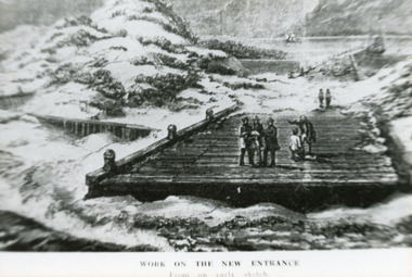
Photograph - Entrance Works, 1880c
Photographed from an early sketchBlack and white photographic postcard showing work in progress on building of entrance piers. On partially built pier, workmen standing on decking, sand dunes and lake at back and Jemmys Point in background. Lakes Entrance VictoriaWork on the new entrance, from an early sketch waterways, public works, piers -
 Lakes Entrance Historical Society
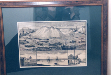
Photograph - Entrance Works, 1875c
Photograph of a framed lithograph showing building of entrance from Gippsland Lakes to ocean Bass Strait. Four black and white detailed drawings shown. Lakes Entrance Victoria waterways, public works -
 Lakes Entrance Historical Society
Photograph - Bridges, Lakes Post Newspaper, 1999
Image appeared in Lakes Post 19 May 1999|Also two other photographs similarColour photograph of repairs to the Cunninghame Arm Footbridge, shows Burys Slipway barge and workmen. Surf Lifesaving Clubroom on dunes in distance. Lakes Entrance Victoriabridges, waterways, topography -
 Lakes Entrance Historical Society
Photograph - Bridges, Scarce, Keith, 1955
Colour photograph of the W L Sides and Son drilling rig beside the bridge over the Mitchell River, testing for foundations for the planned new bridge. Bairnsdale Victoriabridges, waterways, machinery -
 Lakes Entrance Historical Society
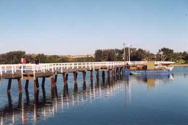
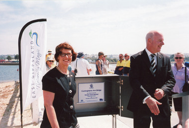
Photograph - Footbridge, 2009
Date made 12 November 2009, 3 other photosColour photograph taken at the official opening of the new footbridge across Cunninghame Arm, Lakes Entrance, Victoria.bridges, transport, waterways, celebration, local history -
 Lakes Entrance Historical Society
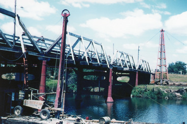
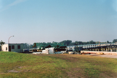
Photograph, 2008
Date made December 2008 plus 7 other photosColour photograph of building of the new footbridge over Cunninghame Arm showing method of construction and application of concrete surface. Lakes Entrance Victoriabridges, waterways, construction -
 Lakes Entrance Historical Society
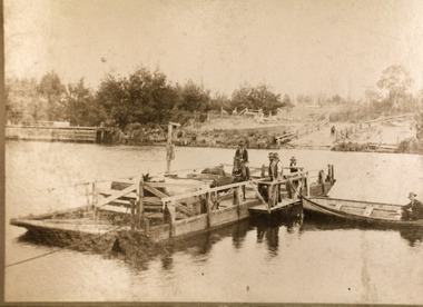
Photograph - Johnsonville Punt, Hancock, Phillip, 1920
Also black and white 10 x 15 cm copy donated by M Holding January 2012Sepia toned copy of a postcard showing the punt at the Tambo River, one man on horse, three men standing, cattle penned on punt, one man in rowing boat tied to punt. Jetty near landing on far bank of river. Johnsonville Victoria waterways, transport, animals, boating