Showing 127086 items
matching main-road
-
 Whitehorse Historical Society Inc.
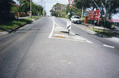
Photograph, Rooks Road, Mitcham, 1/10/2000 12:00:00 AM
Coloured photograph of Rooks Road, Mitcham looking south. Eastbridge Migrant Hostel would have been on right. Building vacated by Australia Post in February 2000.rooks road, mitcham -
 Whitehorse Historical Society Inc.
Postcard, Historic Postcard - Set 2 no 5 - Boronia Road, c1920
Black and white historic postcard (Set 2 No 5 ) Boronia Road, Vermont approaching Dandenong Creek, Vermont in the 1920s. Photo supplied by Nunawading Historical Societydandenong creek, vermont, nunawading historical society, boronia road, vermont, nunawading library & information service -
 Whitehorse Historical Society Inc.
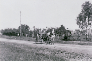
Photograph, Berwyn-Canterbury Road, 22/12/1916 12:00:00 AM
Black/white copy - Horse and jinker outside Homestead Berwyn on Canterbury Road. Included in letter from Gwen M. Jones to her uncle William Jacksonjones, gwen m., canterbury road, blackburn, poultry farms, 'berwyn' -
 Whitehorse Historical Society Inc.
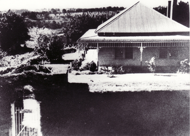
Photograph, 'Harwood' 17 - 21 Junction Road, Blackburn
Black and white photo of 'Harwood' a home at 17 - 21 Junction Road, Blackburn. Home was be wrongly described as the Slater home. See ND1270 at G-H 53.slater, william henry -
 Whitehorse Historical Society Inc.
Photograph - Black and white photograph, 'Harwood' 17 - 19 Junction Road Blackburn
Black and white photo of 'Harwood' a home at 17 - 21 Junction Road Blackburn. Home was wrongly described as the Slater home. See ND1270 at G-H 53.harwood, junction road, blackburn north nos. 17-21 -
 Whitehorse Historical Society Inc.
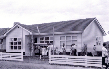
Photograph, 430 Springvale Road Forest Hill, 1960
Black & white photo of a brick veneer Display Home built by 'Hallmark' Homes at 430 Springvale Road Forest Hill.|See also NP3509-3513 &NP3516springvale road, forest hill, no. 430, aldag, ron, hallmark exhibition houses 1960, brick veneer -
 Camberwell Historical Society
Ephemera (Item) - File, Neville Lee, Case for Conservation - former Wesleyan Chapel 200 Glen Iris Road, Glen Iris, 1999-2000
camberwell, glen iris, council, boroondara -
 Melbourne Tram Museum
Photograph - Digital Image, Dick Jones, X2 676 in Albert Road, South Melbourne, Apr. 1970
Digital image of X2 676 in Albert Road, South Melbourne. Tram showing Football, most likely on a tram tour. Photo by Dick Jones - reference - 676_AlbertRd_DickJones_7004M3.13.148trams, tramways, x2 class, albert road, football, tram 676 -
 Whitehorse Historical Society Inc.
Document, Roads, 1/03/1937
Claim by Shire of Blackburn and Mitcham for reimbursement from Country Roads Board for amounts expended on the Main Healesville Road (now Whitehorse Road), March 1937.healesville road, roads and streets, victoria. country roads board, shire of blackburn and mitcham, whitehorse road, nunawading -
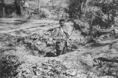
 Eltham District Historical Society Inc
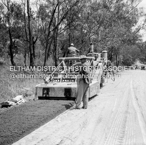
Negative - Photograph, J.A. McDonald, Eltham, Mount Pleasant Road, c.May 1958
Stabilising just below Metery Road below Metery Road No. 18 just visible at left of viewRecord of various Shire of Eltham infrastructure works undertaken during the period of 1952-1962 involving bridge and road reconstruction projects, sometimes with Eltham Shire Council Project Reference numbers quoted. It was during this period that a number of significant improvements were made to roads and new bridges constructed within the shire that remain in place as of present day (2022). In many situations, the photos provide a tangible visible record of infrastructure that existed throughout the early days of the Shire. The album was put together by or under the direction of the Shire Engineer, J.A. McDonald.infrastructure, shire of eltham, 1958-05, footpaths and gutters, mount pleasant road, road construction -
Whittlesea Historical Society Inc.
Document - Contract, Contract No.16, Shire of Whittlesea, Victoria. Running Creek Road, undated
Specifications for Clearing and Farming Twelve Chains of Road and the construction of a Culvert on the Running Creek Road near Grimshaw's.Sheet of paper folded in half with appropriate information written by hand.Contract signed by William Henry Lockwood, Engineer, with Christopher Green and Donald McLeod.contract, william lockwood, grimshaw, running creek road, christopher green, donald mcleod -
 Melbourne Tram Museum
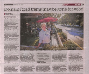
Newspaper - Newspaper clipping, The Age Newspaper, Domain Road trams may be gone for good, 26-03-2023
Article written by the Age transport Reporter, Patrick Hatch. Discusses the possible non-return of trams to Domain Road following the opening of the new tram interchange at ANZAC station. Tram route 8 from Coburg to Toorak was axed when Domain Road closed to St Kilda Road in 2017, and it was combined with route 55 to create a new 58 route. which travels 400 metres further south along St Kilda Road and tuns eastward along Toorak Road.Newspaper clipping from the Age titled: "Domain trams may be gone for good"tramways, trams, route 8, route 58 -
 Mt Dandenong & District Historical Society Inc.
Photograph
Jim Keogh owned Lot 7 of the Village Settlement. When the new CRB road went through c1920 his block was cut through leaving a small triangle of land on the high side of the CRB road. He built a shop on this piece of land. The store burned down 31/12/1939. The woman on the step in this photo is Win Woodcock.Sepia image of a woman standing in front of a wooden store. Handwritten inscription on reverse by John Lundy-ClarkeJim Keogh's shop on the north west corner of Falls and Main Roads. Opposite diagonally from St Michael's Church of England. photo Nov 1926.jim keogh, keogh, store, shop, crb road, win woodcock -
 Eltham District Historical Society Inc
Negative - Photograph, J.A. McDonald, Road Reserve Housing, Mar. 1961
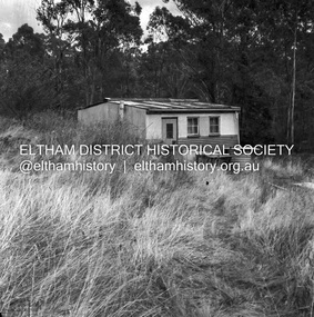
Shack built on road reserve without permit Most probably up on Simms Road, Kinglake Other areas where illegal shacks were built wer at the junction of Flat Rock Road and Cherry Tree Road, Hurstbridge. At times, Building Surveyor George E Newton would have to attend to these shacks for inspection and issue demolition ordersRecord of various Shire of Eltham infrastructure works undertaken during the period of 1952-1962 involving bridge and road reconstruction projects, sometimes with Eltham Shire Council Project Reference numbers quoted. It was during this period that a number of significant improvements were made to roads and new bridges constructed within the shire that remain in place as of present day (2022). In many situations, the photos provide a tangible visible record of infrastructure that existed throughout the early days of the Shire. The album was put together by or under the direction of the Shire Engineer, J.A. McDonald.infrastructure, shire of eltham, 1961-03, building surveyor, cherry tree road, flat rock road, george e. newton, houses, hurstbridge, kinglake, road reserve, road reserve housing, scan - 120 format 6x6 negative, shack, simms road -
 Eltham District Historical Society Inc
Negative - Photograph, J.A. McDonald, Road Reserve Housing, Mar. 1961
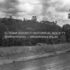
Shack built on road reserve without permit Most probably up on Simms Road, Kinglake Other areas where illegal shacks were built wer at the junction of Flat Rock Road and Cherry Tree Road, Hurstbridge. At times, Building Surveyor George E Newton would have to attend to these shacks for inspection and issue demolition ordersRecord of various Shire of Eltham infrastructure works undertaken during the period of 1952-1962 involving bridge and road reconstruction projects, sometimes with Eltham Shire Council Project Reference numbers quoted. It was during this period that a number of significant improvements were made to roads and new bridges constructed within the shire that remain in place as of present day (2022). In many situations, the photos provide a tangible visible record of infrastructure that existed throughout the early days of the Shire. The album was put together by or under the direction of the Shire Engineer, J.A. McDonald.infrastructure, shire of eltham, 1961-03, building surveyor, cherry tree road, flat rock road, george e. newton, houses, hurstbridge, kinglake, road reserve, road reserve housing, scan - 120 format 6x6 negative, shack, simms road -
 Eltham District Historical Society Inc
Negative - Photograph, J.A. McDonald, Road Reserve Housing, Mar. 1961
Shack built on road reserve without permit Most probably up on Simms Road, Kinglake Other areas where illegal shacks were built were at the junction of Flat Rock Road and Cherry Tree Road, Hurstbridge. At times, Building Surveyor George E Newton would have to attend to these shacks for inspection and issue demolition ordersRecord of various Shire of Eltham infrastructure works undertaken during the period of 1952-1962 involving bridge and road reconstruction projects, sometimes with Eltham Shire Council Project Reference numbers quoted. It was during this period that a number of significant improvements were made to roads and new bridges constructed within the shire that remain in place as of present day (2022). In many situations, the photos provide a tangible visible record of infrastructure that existed throughout the early days of the Shire. The album was put together by or under the direction of the Shire Engineer, J.A. McDonald.infrastructure, shire of eltham, 1961-03, building surveyor, cherry tree road, flat rock road, george e. newton, houses, hurstbridge, kinglake, road reserve, road reserve housing, scan - 120 format 6x6 negative, shack, simms road -
 Melbourne Tram Museum
Pamphlet, Public Transport Victoria (PTV), "Tram service changes Elizabeth St tram track renewal stage 1", "Tram service changes - Routes 70 and 75 - Intersection of Power St, Wallen Road and Riversdale Road Burnley", "Your new Victoria Street accessible stops", 2012 and 2016
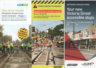
Set of three pamphlets advising of changes to tram services for the renewal of tram track works. All give the relevant service changes and maps. .1 - "Tram service changes Elizabeth St tram track renewal stage 1" - April 2012 - 2 fold DL .2 - "Tram service changes - Routes 70 and 75 - Intersection of Power St, Wallen Road and Riversdale Road Burnley" - June to July 2012 - 3 fold DL .3 - "Your new Victoria Street accessible stops" - Feb,. 2016 - 4 fold DL, including a Vietnamese translation. Details work between Hoddle and Church Streets. .4 - Route 70 - Swan St Burnley track renewal - 9 to 11 Jun 2012 - 3 fold DL 5 - Fitzroy St and The Esplanade - superstops.11/6 to 17/6/2011 - 3 fold DL Produced by Public Transport Victoria and Yarra Tramstrams, tramways, public transport, tram stops, elizabeth st, hawthorn, riversdale junction, wallen rd, route 70, route 75, route 109, victoria st, route 12, swan st, esplanade, route 70, fitzroy st -
 Melbourne Tram Museum
Photograph - Digital Image, Public Transport Victoria (PTV), "St Kilda Road and High Street - Buses replace trams - Sunday 13 Oct. to Sunday 27 Oct.", Oct. 2019
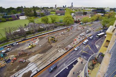
.1 - Pamphlet - 2 x 3 fold x titled "St Kilda Road and High Street - Buses replace trams - Sunday 13 Oct. to Sunday 27 Oct." 2019 for works at Domain, Park and St Kilda Road and track relay in High Street between St Kilda Road and Williams Road. Gives alternative bus routes. Part of the work was for the construction of the Noise Box or acoustic shed over the future Anzac Station site - part of the Metro Tunnel Works and track relocation. See htd3930i2.pdf for a detailed description of the work from the Metro Tunnel authority - Rail Projects Vic. This file does not want to open properly using dbtext works, access directly. Image i3 - from tdu website https://tdu.to/m/262235/re-d2-5005-at-temporary-tram-termin-us-st-kilda-road, shows the works underway. Posted by Metro Tunnel on twitter today showing progress on relocating tram tracks at site of Anzac station. This will allow construction of the southern box of the station. Large file (~2.6MB and 4096x2733 pixels, but enables you to get "up close and personal".trams, tramways, park st, domain junction, metro tunnel, toorak rd, st kilda rd, tramway construction -
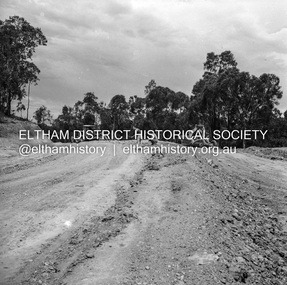
 Eltham District Historical Society Inc
Album - Photograph, J.A. McDonald, Smiths Gully Road, Nov. 1952
November 1952 Smiths Gully Road between Hall and One Tree Hill Road (D. Cole in foreground)Record of various Shire of Eltham infrastructure works undertaken during the period of 1952-1962 involving bridge and road reconstruction projects, sometimes with Eltham Shire Council Project Reference numbers quoted. It was during this period that a number of significant improvements were made to roads and new bridges constructed within the shire that remain in place as of present day (2022). In many situations, the photos provide a tangible visible record of infrastructure that existed throughout the early days of the Shire. The album was put together by or under the direction of the Shire Engineer, J.A. McDonald.infrastructure, shire of eltham, bridge construction, road construction, 1952-11, smiths gully, smiths gully road, d. cole -
 Eltham District Historical Society Inc
Negative - Photograph, J.A. McDonald, Heidelberg-Kinglake Road, 3 Nov. 1959
Job 56M430 Contractor Hone Curve improvement at Youngs Road – old road on right 3 November 1959Record of various Shire of Eltham infrastructure works undertaken during the period of 1952-1962 involving bridge and road reconstruction projects, sometimes with Eltham Shire Council Project Reference numbers quoted. It was during this period that a number of significant improvements were made to roads and new bridges constructed within the shire that remain in place as of present day (2022). In many situations, the photos provide a tangible visible record of infrastructure that existed throughout the early days of the Shire. The album was put together by or under the direction of the Shire Engineer, J.A. McDonald.infrastructure, shire of eltham, bridge construction, heidelberg-kinglake road, road construction, 1959-11-03 -
 Greensborough Historical Society
Slide - Photograph, John Ramsdale, Plenty Road near Parade College: Slide 29, 1990s
Photograph shows a 3-lane road with "Federally funded" sign This is Plenty Road Bundoora, near Parade college.Part of the John Ramsdale collection of slides and audio visual material.Colour photograph scanned from slide.No caption. Printed maker's mark on slide "Kodak Kodachrome Slide"plenty road bundoora, parade college -
 Greensborough Historical Society
Slide - Photograph, John Ramsdale, Middle Gorge Park on Gorge Road: Slide 41, 1990s
Photograph shows a bridge with van, road is on steep hill. This is the carpark at Middle Gorge Park on Kurrak Road Yarrambat.Part of the John Ramsdale collection of slides and audio visual material.Colour photograph scanned from slide.No caption. Printed maker's mark on slide "Kodak Kodachrome Slide"middle gorge park, kurrak road yarrambat, plenty gorge metropolitan park -
 Eltham District Historical Society Inc
Slide - Photograph, View towards Garden Hill, Eltham-Yarra Glen Road, Kangaroo Ground, c.May 1988
Looking towards the Shire of Eltham Memorial Park on top of Garden Hill,, Eltham-Yarra Glen Road, Kangaroo Ground, c.May 1988. Viewed from near intersection of Kangaroo Ground-Warrandyte Road and Eltham-Yarra Glen Road35mm colour positive transparency (2 of 36) Mount - Kodak KodachromeProcess Date MAY 88Meltham-yarra glen road, kangaroo ground, shire of eltham memorial park, shire of eltham war memorial -
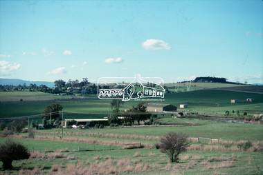
 Whitehorse Historical Society Inc.
Photograph, Whitehorse Road Sign, C1940s
2 copies of sign on south side of Whitehorse Road opposite Dunlavin Road, Mitcham, looking east. Early 1940s. Note in 1870 the area was known as Air Hill. (See also NP941) Center of shot shows shop on west side of what later became Alexander Street and further east house on the corner of Peel Street.These signs are very similar to those erected in nearby Vermontadvertising signs, whitehorse road, mitcham, dunlavin road -
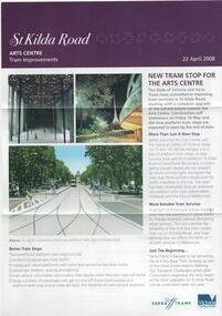 Melbourne Tram Museum
Pamphlet, Yarra Trams, "St Kilda Road - Arts Centre Tram Improvements", April 2008
Pamphlet - 3 fold A4 pamphlet, full colour, titled "St Kilda Road - Arts Centre Tram Improvements" detailing the construction schedule and photos of the Superstops and additional tracks outside the Arts Centre in St Kilda Road. Shows a track layout including a revised junction for South Melbourne Trams and Southbank Boulevard. Has Yarra Trams and State Government logos. Dated 24/4/2008.trams, tramways, st kilda rd, arts centre, road works, superstops -
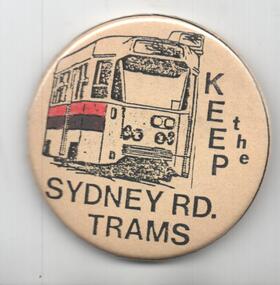 Melbourne Tram Museum
Ephemera - Badge/s, Badge Minit, "Keep the Sydney Road Trams", late 1980's
Badge - featuring the front of a Z class tram with the words "Keep the Sydney Road Trams". Has a pin with a white plastic backing on the rear to enable to be fixed to an item of clothing. Has manufacturer's name and logo on the rear of badge - Badge Minit. Advised by Neil Elphick 23/6/2018 that they were made at the time by Sydney Road traders when the Upfield Light rail was being considered 1988/1989.trams, tramways, the met, conductors, melbourne, badges, sydney rd, upfield light rail -
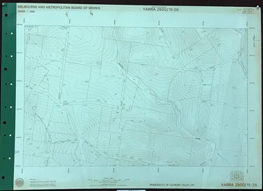 Greensborough Historical Society
Map, Melbourne and Metropolitan Board of Works. Survey Division, MMBW, Yarra 2500 / 15.26. Yarrambat, Hacketts Road, 1978_07
Melbourne and Metropolitan Board of Works. Yarra 2500 [base map] 15.26. Yarrambat, Hacketts Road. Municipality of Diamond Valley 257. Prominent streets include: Black Gully Road, Hacketts Road and Collins Lane. Features include Scrubby Creek.MMBW Map in 1:2500 [scale] series. Cream parchment with green tape reinforcing on edges and punched holes on left edge.mmbw, melbourne and metropolitan board of works, shire of diamond valley, yarrambat - maps -
 Eltham District Historical Society Inc
Photograph, Fay Bridge, Looking north towards Diamond Creek from the high point of Allendale Road, Diamond Creek, n.d
Situated opposite the driveway of 170 Allendale Road, Research, just east of where the Maroondah Aqueduct Trail crosses the roadfay bridge collection, allendale road, diamond creek, fences, research (vic.) -
 Eltham District Historical Society Inc
Photograph, Baldwin Avenue at Lilicur Road, Montmorency, c.1972, 1972c
Shire of Eltham road construction and realignment works on Baldwin Avenue, Lilicur Road and Price Avenue, Montmorency, c.197235mm colour positive transparency blue Agfacolour Service plastic mountbaldwin avenue, infrastructure, lilicur road, montmorency, road construction