Showing 7150 items
matching way
-
 Eltham District Historical Society Inc
Document - Folder, Mitchell, Grace
Grace Mitchell (nee Whieldon) was born in Yarram Gippsland, second of nine children. After her father died, the family moved to Creswick. She left home at age 12 to earn a wage to help the family, including as a matron at the School of Mines in Creswick and, after moving to Melbourne, as dietitian at Royal Melbourne Hospital. After marrying Arthur Mitchell, they moved to Mount Pleasant Road, Eltham, in 1948. Because Arthur had an accident and was not able to work, she did various jobs before starting a cake shop in their house; she also cooked at Montsalvat,. She was also a tailor and dressmaker, studied psychology and journalism, her crochet.patterns were published in 'New Idea' as a girl when she also started carving wood.She knew many artists, writers, etc.As a widow, in her late 60s, she enrolled in a diploma of arts course, majoring in sculpture and print-making. Contents Newspaper article: "Amazing Grace!", Diamond Valley News, 7 July 1981. Newspaper article: "A way with wood", The Age, ?1999. Diamond Valley News, 30 April 1985. Describes life of Grace Mitchell, just turned 80, who began carving wood as a girl. Newspaper article: "Paging women to celebrate", Heidelberg and Diamond Valley Weekly, 12 February 2008. To promote nominations for 'Celebrating Nillumbik Women', designed to honour women, Grace and Jenni Mitchell are featured. Newspaper article: "Celebrate history and her story", Diamond Valley Leader, 20 February 2008. To promote nominations for 'Celebrating Nillumbik Women', designed to honour women, Grace and Jenni Mitchell are featured. Newspaper article: "Eltham artist's will to live", Diamond Valley Leader, 27 October 2010. Grace Mitchell recovering in Austin Hospital. Order of Service: A celebration and thanksgiving for the life of Grace Mitchell, Montsalvat Eltham, 19 April 2011. Newspaper article: "Death of an Eltham icon", Diamond Valley Leader, ?20 April 2011. Obituary of Grace Mitchell with tributes from Ona Henderson, Sigmund Jogensen, Jenni Mitchell. Newspaper article: "Amazing Grace remembered", Diamond Valley Leader, 27 April 2011. Report of Service for Grace Mitchell at Montsalvat. Newspaper article: "Thanks Eltham for your kind messages", Diamond Valley Leader 18 May 2011. Letter from Jenni Mitchell, thanks for messages. Newspaper article: "Eltham all-rounder a remarkable gem", The Age, 13 May 2011. Obituary for Grace Mitchell. Newspaper article:"Search for home for ark art", Diamond Valley Leader, 11 November 2011. Grace Mitchell's work 'The Ark" 1983, is on display at local MP's office, seeking a home in a public collection. Newsletter article: "Jenni Mitchell - 'May mother Grace'", Eltham District Historical Society newsletter No.207, November 2012. Notice that Jenni Mitchell will talk about her mother's work at the November meeting. Flier: Eltham South Fine Art Studios and Gallery, 7 October-18 November 2012"Grace Mitchell 1916-2011: The Artist's Work: A Selected Retrospective". Handout: Sheet to accompany Eltham South Fine Art Studios and Gallery, 7 October-18 November 2012"Grace Mitchell 1916-2011: The Artist's Work: A Selected Retrospective". Biography of Grace Mitchell.Newspaper clippings, A4 photocopies, etcgrace mitchell, jenni mitchell, alan marshall, clifton pugh, robert helpmann, katherine hepburn, phillip institute of technology, celebrating nillumbik women, austin hospital, mount pleasant road eltham, montsalvat eltham, sigmund jorgensen, ona henderson, helen coleman, gail pritchard, school of mines creswick, mitchell's homemade cakes and pies, susan toole, eltham cemetery, arthur mitchell, mervyn hannan, vicki ward -
 Eltham District Historical Society Inc
Photograph, Upper Yarra Dam, Spring Tour, 22 Oct 1995, 22/10/1995
EXPLORING THE UPPER YARRA (Newsletter No. 105, November 1995, by Bettina Woodburn) We enjoyed the Spring Excursion, this year "Exploring the Upper Yarra" - in spite of the constant rain and the countryside under the cloud cover, especially in the valleys, being mainly shiny shades of green. The occasional fields of buttercups, clumps of arum lilies and splendid rhododendron and other flowering bushes became very special. The Cobb and Co coach was warm and a cosy retreat as we zig-zagged on the highways and byways to glimpse the Yarra River, upstream and down, its secret places, and particularly the many bridges. Russell excelled as 'Poet Laureate', reading from Dacre Smyth's book. This 1979 publication includes paintings of all the bridges along the river with poems and brief descriptions of each one. Some of the bridges are in out of the way places and are not very well known. We looked forward to hearing the poetry as much as seeing the ' constructions'…Big Pat (was he short or tall, lean or fat? He did win the two hundred pound reward for discovering gold and had the creek named after him), about the 'Eddies'?, and the disliked 'meccano' bridge in Warburton, etc. etc. The hot roast lunch in the old Reefton Hotel was also most welcome. It was easy to imagine it peopled by miners and early settlers. Starting by crossing the new (1974) concrete bridge at Warrandyte we headed through Wonga Park with views to the Christmas Hills and to the escarpment of the Yering Gorge, which causes flood waters to back up through the Yarra Glen plain, so avoiding disasters downstream. At the end of a long driveway we found the wooden, privately owned Henley Bridge (1935 after the 1934 floods). This facilitates access to different parts of Henley Farm and to Lilydale. Everard Park, named after Blanche Shallard's father, a State Member for 17 years, below the Highway Yarra crossing was in need of care. It is 10 miles from Yarra Glen by road but, as "Yarra Marra” canoeists well know, 32 winding miles down by water. After more delightful countryside scenes we joined the Warburton Highway at Woori Yallock. From the old Railway Station at Launching Place the Centennial Trail for walkers, cyclists and ' horse riders has replaced the rails. The line from Lilydale was opened in 1901, and the last diesel freight train ran to Warburton in 1965. It continued to rain as we had morning tea in Warburton in a shelter between footbridges. From here we continued upstream past the Bridge to O'Shannasy Lodge and Reservoir, Starvation Creek, and the Peninsular tunnel (miners dug it as at Pound Bend) which we visited (scrambling down those steps!) on our return after lunch. Our furthermost point was the Upper Yarra Dam Reserve (and vast catchment area). Finished in 1957 after ten years work and 100 years after Yan Yean, it supplies much of Melbourne's water. After crossing the 30m Launching Place Bridge to the Eltham side of the Yarra and Healesville, we saw in the distance the Yarra Glen Timber Trestle Bridge over the river flats "the longest for years in the land it was said!" Harry's dream of "better weather over the Divide" unfortunately didn't come true, but I'm sure we 36 members will retain happy memories of a day that was wet and green and filled with Bridges. Bettina Woodburn - October 1995 Record of the Society's history of activities - Spring 1995 excursionColour photographshire of eltham historical society, activities, upper yarra dam, henley bridge -
Federation University Historical Collection
Photograph - Image, Yarrowee Hall, Redan, c1883
ROBERT MALACHY SERJEANT (1828-1902) Robert Malachy Serjeant was born on 21 December 1828 at Callington, Cornwall. He was the son of Philip Davey Serjeant, a surgeon in the Royal Marines, and Eliza Malachy. Philip Serjeant died in 1834. His mother, Eliza, remarried John Burgh in 1836. He died in 1837. In September 1848 Eliza, Robert and his two sisters, Caroline and Susan, departed Plymouth on the William Moneya for Port Adelaide and arrived in January 1849. Once gold was discovered in Victoria, Serjeant made his way to Forest Creek (near Castlemaine) and he and his mate Mr Victor, were the first party to sink through the basalt in search of a deep lead. In 1854 he moved to Ballarat to work as a miner and enjoyed some success. In 1855 he was with a group that discovered a 500 ounce nugget. With his share of the sale he set himself up with the latest mining equipment, as well as beginning a lifelong interest in the share market. He became the Manager of the Chryseis, Isis and Garibaldi claims and then the Manager of the Band and Albion Consol Company. He held the position for thirty years and only resigned when the company amalgamated with the Sir Henry Loch Mine. Robert Malachy Serjeant became interested in Politics. The first election for Parliament Representatives for Ballarat was in 1855. Robert stood for election for the first time in 1859, representing Ballarat West. He was also elected to represent Ballarat West in 1874 and 1880. Robert Serjeant’s community involvement extended to Education. Years of discussion eventually saw the development of the Ballarat School of Mines, the first school of mines in Australia. The inaugural School Council was formed in 1870 with Sir Redmond Barry, the Chief Justice, as President and Robert Malachy Serjeant as a member of the council. He held a position on the council until illness forced him to retire in 1889. He was elected a Life Governor in 1889. He was also a Life Governor of the Ballarat Hospital. Robert Serjeant showed Prince Albert and Prince George (later King George V) around the Band and Albion Mine. At the age of 42, Robert enrolled as a student at the School of Mines in 1871. He obtained a Certificate of Competency in Assaying (including Metallurgy) in 1875. The first certificate in “Geology as Applied to Mining” was awarded to Robert Serjeant in 1876. Robert Serjeant was an active and generous supporter of the School of Mines. As well as being a financial contributor, he lectured and examined in the Principles and Practice of Mining. He was regarded as an authority on alluvial and quartz mining and was a member of the Ballarat Local Court and mining board. In 1977 Robert, Joseph Flude and Henry Caselli donated the patent rights of a novel Pyrites furnace to the school. The R.M. Serjeant Scholarship at the Ballarat School of Mines resulted after a reward was offered for the first to produce the best method of treating auriferous ores – other than the smelting method. The offer was open for two years but not awarded. The money for this was donated by Robert Serjeant to the amount of 256 Pounds. It was then used to fund the School of Mines Scholarship in Engineering (1889). It was first awarded in 1922. Robert Malachy Serjeant died on 25 October 1902 and was buried at the Ballaarat Old Cemetery. (Sometimes Malachy is incorrectly written as Malachi)An copy of a photo of Yarrowee Hall, the home of of mine manager Robert Malachy Serjeant. robert malachy serjeant, r.m. sergeant, robert malachi serjeant, band of hope and albion consols, yarrowee hall, redan -
 Flagstaff Hill Maritime Museum and Village
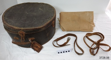
Functional object - Hat box, early to mid-20th century
This large hat box was owned by Miss Katherine Robertson (now deceased). It was sold by Drews, a leather and travel goods shop in Melbourne, and has been made as good quality, sturdy travel luggage. It has its own leather luggage label buckled to the handle and there are remnants of labels on the base of the hat box, signifying that it has indeed been used as luggage. A hat box such as this one is made to protect, store and transport head wear. Hat boxes became popular in the 19th and early 20th century when hats were a part of the modern fashion. Inside the hat box is a brown paper wrapper with two Great Britain postage stamps attached. Both have the portrait image of Queen Elizabeth II (1) orange 1/2d (2) green ten pence. These stamps belong to the Wildings series and were issued 1952-1954. The wrapper was sent by J McGregor in Glasgow, Scotland to Katherine Robertson in Sale, Victoria. The postmark stamp shows it was sent in 1955. The paper had once been folded around something rectangular in shape, perhaps a book. The hat box was recently found by Archie’s daughter, niece of Katherine, when she was looking for something else in the ceiling of her home. The hat box had been there, with the brown paper wrapper inside, for about 30 years, forgotten by the family. There are no family members remaining now to tell the full story. ABOUT MISS KATHERINE ROBERTSON The Robertson family emigrated from the Isle of Wight and settled in Woorndoo, Western Victoria, Australia. Katherine Robinson was the 10th child of 13 children, born in 1906 and lived until 1995. The youngest child in the family was a boy named Archibald (Archie) who was born in 1911. His daughter is the donor of the hat box. Katherine went to school at Woorndoo and later became a trained teacher. She taught in many places, amongst them were Alexandria, Geelong, Sale, Stawell and Ballarat. People said “She was a school teacher 24 hours a day!” She was insistent on being called Miss Katherine Robinson, and no-one dare call her a shortened name in any way, not Kate, or Katie or even Kathie. She spoke with the authority of a teacher throughout her life, never asking but always giving her requests as orders. Miss Katherine Robinson remained single all her life. She bought items that were the best quality and workmanship, which gives reason for the strong and well-travelled hat box. She enjoyed going on trips and travelled the world twice. While on her journeys Katherine would knit Fair Isle patterned socks using fine 4 ply wool because she “Didn’t believe in wasting time!” Katherine’s niece remembers being in Melbourne at Station Pier, seeing her Aunt off on one of her journeys. She recalls the atmosphere and the colourful streamers in the air that celebrated the special occasion. Katherine travelled on the Oriana and Fair Star lines. ABOUT DREWS Drew’s, Leather Goods Specialists, was located at 70 Swanston St, corner of Queen’s Walk, Melbourne, at the time that this hat box was sold by the company. Queen’s Walk was constructed in 1889. It was a lavish ‘L’ shaped arcade that connected Swanston Street to Collins Street and was home to many specialist stores. In the 1950’s Drews address was advertised as Collins Street. In the late 1960’s Queen’s Walk was purchased by the Melbourne City Council and demolished in the early 1970’s, to be replaced by the Melbourne City Square. This very sturdy and good quality hat box is an example of travel luggage available to and used by the Victorian population of Australia in the early to mid-20th century. The retailer of this hat box, Drews, operated from premises on the corner of Swanston St and Queen’s Walk in Melbourne where many other specialist shops were located. Queen’s Walk was only in existence for around 70 years, 1889-late 1960, before it was demolished to make way for Melbourne’s City Square. Hat box, large, deep round shape with a straight section where lid is joined on at the back. Dated early to mid-1900’s. Brown coloured, textured heavy weight card box with folding metal carry handle, three clip closures for lid, metal hinge on back of lid. Purple maker’s label inside lid - DREWS, Leather Goods Specialists, Melbourne. Leather luggage tag has two rectangular cut-outs on front, attached with buckle strap. Underside of lid has two supporting leather straps attached to base. Base has inner cardboard liner around most of circumference. Contained inside are two leather straps with metal buckles. Label remnants, red, attached under base. Hat box was owned by Miss Katherine Robertson. Also inside is brown paper wrapper with three hand written addresses, in blue nib pen, and two attached Great Britain postage stamps, Queen Elizabeth II (1) Orange stamp, QE II, ½d (2) Green stamp, QE II, ten pence. It is postmarked [19] 55. Purple label has printing "70 SWANSTON STREET / Cr. QUEEN'S WALK / DREWS / LEATHER GOODS / SPECIALISTS / MELBOURNE". Wrapper inside has two hand written addresses (1J) Mrs. K. F. Robertson / 33 Mcalister Street / Sale / Victoria / Australia” (2) “from / J Mc Gregor / 15 Napier’s Hall St / Glasgow N W / Scotland” Postmark “ - -em 55” & “CLAS-“ OR “GLAS-“ [GLASGOW] flagstaff hill, warrnambool, shipwrecked coast, flagstaff hill maritime museum, maritime museum, shipwreck coast, flagstaff hill maritime village, great ocean road, luggage, hat box, hatbox, hat storage box, hat travel case, hat case, bandbox, drews melbourne, drew’s melbourne, drew’s handbags, travel goods, travel luggage, hat box suitcase, hat box luggage, 1952-1954 gb postage stamps 1/2d orange queen elizabeth ii, katherine robertson, archibald (archie) robertson of woorndoo, j mcgregor -
 Mission to Seafarers Victoria
Article, Kerrie O'Brien, Want to peek inside Melbourne’s finest mansions and buildings? This is your chance, 30 June 2022
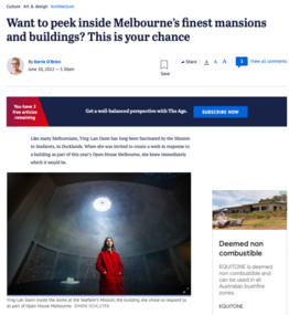
Open House 2022: "Like many Melburnians, Ying-Lan Dann has long been fascinated by the Mission to Seafarers, in Docklands. When she was invited to create a work in response to a building as part of this year’s Open House Melbourne, she knew immediately which it would be. Taking a peek behind the closed doors of some of Melbourne’s finest and most interesting buildings is a core premise of the weekend event, now in its 15th year. During that time, the program has grown from half a dozen buildings to a 200-plus strong list that extends to Ballarat and Bendigo. “[It’s] much more expansive and citizen-led,” says Fleur Watson, Open House Melbourne’s executive director. “As a public festival, it has always had a spirit of generosity, this gesture of opening up and allowing visitors to come and look and experience things.” Swinging open their doors at the end of the month will be some of the city’s finest mansions, including Villa Alba in Kew and Brighton’s Billilla, the Cairo flats in Fitzroy, the newly renovated Jewish Museum designed by Kerstin Thompson, the Melbourne Quakers Centre, the Albanian Mosque in Carlton North and many more. Considering how to approach the event this year, held remotely for the past two, Watson decided to explore beyond the traditional, with associate professor and director of curatorial practice at Monash University Tara McDowell. The two have co-curated an exhibition of works to run concurrently with the Open House program, called Take Hold of the Clouds. That’s where Dann’s work, Circular Temporalities, comes in, one of seven commissions around town in which local and international artists respond to chosen buildings or sites. A lecturer in interior design at RMIT as well as an artist, she is interested in time and finding different mediums to show things in flux and, having grown up on Phillip Island, she often uses water as a theme. When she started spending time at the Mission, Dann found there was an oculus at the top of the dome, known as the Norla Dome. She thought about how that small but significant opening related to where sailors spent so many months of the year, the sky being the only thing they would see much of the time, stars guiding the way in times gone by, and of the recent stories she’d heard about sailors being trapped at sea during COVID. Built in the Arts and Craft style between 1916 and 1919 and designed by architect Walter Butler, the Mission includes a chapel, clubroom, Chaplain’s house, a small cottage and the Norla Dome, which was apparently inspired by the Pantheon. The Mission was funded by the government and the Ladies Harbour Lights Guild, who Dann was also intrigued by. “One of the things those women identified is that life at sea is very dangerous [and they] wanted to give them a space of sanctuary and support,” she says, adding that for many years, the dome was used as a gymnasium. Her work inside the dome includes a 35-minute loop film, recorded from the ferry during the crossing from Queenscliff to Sorrento. The horizon takes up about a third of the shot and moves as the waves rise and fall, mirroring the journeys made by the sailors who found refuge at the mission over the years; it will be projected onto a gauze-like fabric, allowing glimpses of the building behind. Dann also plans to activate the site over the course of the weekend and will read a poem by Justin Clemens.The articles gives an insight of the création of the artwork by Ying-Lan Dann. digital copy of an article with photographs published in the Ageopen house melbourne, 2022, ying-lan dann, take hold of the clouds, norla dome, exhibition, the age, cultural events -
 Halls Gap & Grampians Historical Society
Newspaper - B/W
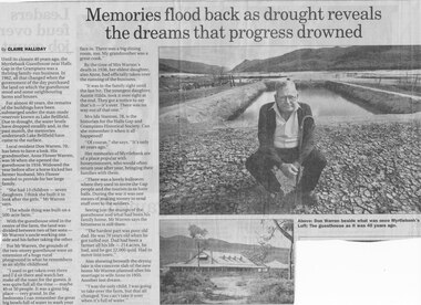
Until the closure 40 years ago, the Myrtlebank Guesthouse near Halls Gap in the Grampians was a thriving family - run business. In 1962, all that changed when the government of the day purchased the land on which the guesthouse stood and some neighbouring farms and houses. For almost 40 Years, the remains of the buildings have been submered under the man made reservoir known as Lake Bellfield. Due to drought, the eater levels have dropped steadily and, in the past month, the memories underneath Lake Bellfield have come to the surface. Local resident Don warren 70, has been to have a look. His grandmother Anne Flower Warren, was 56 when she opened the guesthouse in 1916. Widowed, the year before after a horse kicked her farmer husband, Mrs Flower needed to provide for their large family. "She had 13 children - seven daughters. I think she built it to look after the girls," Mr Warren says, "The whole think was built on a 500 acre farm." With the guesthouse sited in the centre of the farm, the land was divided between two of her sons- Mr Warren's uncle working one side and his father taking the other. For Mr Warren, the grounds of the two-storey guesthouse were an extension of a huge rural playground in what he remembers as an idyllic childhood. "I used to get taken over there and I'd sit there and watch her make all the toast for the guests. It was quite full all the time - maybe 40 or 50 people. It was a great big place - very grand. In the bedrooms I can remember the great big bowls full of water to wash your face in. There was a big dining room, too. My grandmother was a great cook." By the time of Mrs Warren's death in 1936, her eldest daughter also Anne, had officially taken over the running of the business. "It was in the family right until the last bit. The youngest daughter, Auntie Hilda, took it over right at the end. they got a notice to say that's it - it's over There was no way out of that one." Mrs Ida Stanton, 78, is the historian for the Halls Gap and Grampians Historical Society. Can she remember it when it all happened? "Of course" she says "It's only 40 years ago" Her memories of Myrtlebank are of a place popular with honeymooners, who would often return year after year, bringing their families with them. "There was a lovely ballroom where they used to invite the Gap people and the tourists in to have balls. During the war it was one means of making money to send stuff over to the soldiers." Seeing just the stumps of the guesthouse and what had been his family home, Mr Warren says the bitterness is still there. "The hardest part was poor old dad. He was 70 years old when he got turfed out. Dad had been a farmer all his life - 214 acres, he had, and he got 22,000 quid. Had to move into town" Also showing beneath the drying lake is the concrete slab of the new home Mr Warren planned after his marriage to wife Anne in 1955. Another lost dream. " I was the only child, I was going to take over the farm, but that all changed. You can't take it over when it's full of water.Newspaper clipping of history of Myrtlebank by Don Warren and photo of Don at old site of pooland guest House photo Article by Claire Halliday from newspaper 2002accommodation, guesthouses, myrtlebank -
 Eltham District Historical Society Inc
Photograph, Upper Yarra Dam, Spring Tour, 22 Oct 1995, 22/10/1995
EXPLORING THE UPPER YARRA (Newsletter No. 105, November 1995, by Bettina Woodburn) We enjoyed the Spring Excursion, this year "Exploring the Upper Yarra" - in spite of the constant rain and the countryside under the cloud cover, especially in the valleys, being mainly shiny shades of green. The occasional fields of buttercups, clumps of arum lilies and splendid rhododendron and other flowering bushes became very special. The Cobb and Co coach was warm and a cosy retreat as we zig-zagged on the highways and byways to glimpse the Yarra River, upstream and down, its secret places, and particularly the many bridges. Russell excelled as 'Poet Laureate', reading from Dacre Smyth's book. This 1979 publication includes paintings of all the bridges along the river with poems and brief descriptions of each one. Some of the bridges are in out of the way places and are not very well known. We looked forward to hearing the poetry as much as seeing the ' constructions'…Big Pat (was he short or tall, lean or fat? He did win the two hundred pound reward for discovering gold and had the creek named after him), about the 'Eddies'?, and the disliked 'meccano' bridge in Warburton, etc. etc. The hot roast lunch in the old Reefton Hotel was also most welcome. It was easy to imagine it peopled by miners and early settlers. Starting by crossing the new (1974) concrete bridge at Warrandyte we headed through Wonga Park with views to the Christmas Hills and to the escarpment of the Yering Gorge, which causes flood waters to back up through the Yarra Glen plain, so avoiding disasters downstream. At the end of a long driveway we found the wooden, privately owned Henley Bridge (1935 after the 1934 floods). This facilitates access to different parts of Henley Farm and to Lilydale. Everard Park, named after Blanche Shallard's father, a State Member for 17 years, below the Highway Yarra crossing was in need of care. It is 10 miles from Yarra Glen by road but, as "Yarra Marra” canoeists well know, 32 winding miles down by water. After more delightful countryside scenes we joined the Warburton Highway at Woori Yallock. From the old Railway Station at Launching Place the Centennial Trail for walkers, cyclists and ' horse riders has replaced the rails. The line from Lilydale was opened in 1901, and the last diesel freight train ran to Warburton in 1965. It continued to rain as we had morning tea in Warburton in a shelter between footbridges. From here we continued upstream past the Bridge to O'Shannasy Lodge and Reservoir, Starvation Creek, and the Peninsular tunnel (miners dug it as at Pound Bend) which we visited (scrambling down those steps!) on our return after lunch. Our furthermost point was the Upper Yarra Dam Reserve (and vast catchment area). Finished in 1957 after ten years work and 100 years after Yan Yean, it supplies much of Melbourne's water. After crossing the 30m Launching Place Bridge to the Eltham side of the Yarra and Healesville, we saw in the distance the Yarra Glen Timber Trestle Bridge over the river flats "the longest for years in the land it was said!" Harry's dream of "better weather over the Divide" unfortunately didn't come true, but I'm sure we 36 members will retain happy memories of a day that was wet and green and filled with Bridges. Bettina Woodburn - October 1995 Record of the Society's history of activities - Spring 1995 excursionRoll of 35mm colour negative film, 3 stripsKodak Gold 200-4shire of eltham historical society, activities, upper yarra dam, henley bridge -
 Eltham District Historical Society Inc
Photograph, Upper Yarra Dam, Spring Tour, 22 Oct 1995, 22/10/1995
EXPLORING THE UPPER YARRA (Newsletter No. 105, November 1995, by Bettina Woodburn) We enjoyed the Spring Excursion, this year "Exploring the Upper Yarra" - in spite of the constant rain and the countryside under the cloud cover, especially in the valleys, being mainly shiny shades of green. The occasional fields of buttercups, clumps of arum lilies and splendid rhododendron and other flowering bushes became very special. The Cobb and Co coach was warm and a cosy retreat as we zig-zagged on the highways and byways to glimpse the Yarra River, upstream and down, its secret places, and particularly the many bridges. Russell excelled as 'Poet Laureate', reading from Dacre Smyth's book. This 1979 publication includes paintings of all the bridges along the river with poems and brief descriptions of each one. Some of the bridges are in out of the way places and are not very well known. We looked forward to hearing the poetry as much as seeing the ' constructions'…Big Pat (was he short or tall, lean or fat? He did win the two hundred pound reward for discovering gold and had the creek named after him), about the 'Eddies'?, and the disliked 'meccano' bridge in Warburton, etc. etc. The hot roast lunch in the old Reefton Hotel was also most welcome. It was easy to imagine it peopled by miners and early settlers. Starting by crossing the new (1974) concrete bridge at Warrandyte we headed through Wonga Park with views to the Christmas Hills and to the escarpment of the Yering Gorge, which causes flood waters to back up through the Yarra Glen plain, so avoiding disasters downstream. At the end of a long driveway we found the wooden, privately owned Henley Bridge (1935 after the 1934 floods). This facilitates access to different parts of Henley Farm and to Lilydale. Everard Park, named after Blanche Shallard's father, a State Member for 17 years, below the Highway Yarra crossing was in need of care. It is 10 miles from Yarra Glen by road but, as "Yarra Marra” canoeists well know, 32 winding miles down by water. After more delightful countryside scenes we joined the Warburton Highway at Woori Yallock. From the old Railway Station at Launching Place the Centennial Trail for walkers, cyclists and ' horse riders has replaced the rails. The line from Lilydale was opened in 1901, and the last diesel freight train ran to Warburton in 1965. It continued to rain as we had morning tea in Warburton in a shelter between footbridges. From here we continued upstream past the Bridge to O'Shannasy Lodge and Reservoir, Starvation Creek, and the Peninsular tunnel (miners dug it as at Pound Bend) which we visited (scrambling down those steps!) on our return after lunch. Our furthermost point was the Upper Yarra Dam Reserve (and vast catchment area). Finished in 1957 after ten years work and 100 years after Yan Yean, it supplies much of Melbourne's water. After crossing the 30m Launching Place Bridge to the Eltham side of the Yarra and Healesville, we saw in the distance the Yarra Glen Timber Trestle Bridge over the river flats "the longest for years in the land it was said!" Harry's dream of "better weather over the Divide" unfortunately didn't come true, but I'm sure we 36 members will retain happy memories of a day that was wet and green and filled with Bridges. Bettina Woodburn - October 1995 Record of the Society's history of activities - Spring 1995 excursionRoll of 35mm colour negative film, 2 stripsKodak Gold 100-4shire of eltham historical society, activities, upper yarra dam, henley bridge -
 Eltham District Historical Society Inc
Photograph, Upper Yarra Dam, Spring Tour, 22 Oct 1995, 22/10/1995
EXPLORING THE UPPER YARRA (Newsletter No. 105, November 1995, by Bettina Woodburn) We enjoyed the Spring Excursion, this year "Exploring the Upper Yarra" - in spite of the constant rain and the countryside under the cloud cover, especially in the valleys, being mainly shiny shades of green. The occasional fields of buttercups, clumps of arum lilies and splendid rhododendron and other flowering bushes became very special. The Cobb and Co coach was warm and a cosy retreat as we zig-zagged on the highways and byways to glimpse the Yarra River, upstream and down, its secret places, and particularly the many bridges. Russell excelled as 'Poet Laureate', reading from Dacre Smyth's book. This 1979 publication includes paintings of all the bridges along the river with poems and brief descriptions of each one. Some of the bridges are in out of the way places and are not very well known. We looked forward to hearing the poetry as much as seeing the ' constructions'…Big Pat (was he short or tall, lean or fat? He did win the two hundred pound reward for discovering gold and had the creek named after him), about the 'Eddies'?, and the disliked 'meccano' bridge in Warburton, etc. etc. The hot roast lunch in the old Reefton Hotel was also most welcome. It was easy to imagine it peopled by miners and early settlers. Starting by crossing the new (1974) concrete bridge at Warrandyte we headed through Wonga Park with views to the Christmas Hills and to the escarpment of the Yering Gorge, which causes flood waters to back up through the Yarra Glen plain, so avoiding disasters downstream. At the end of a long driveway we found the wooden, privately owned Henley Bridge (1935 after the 1934 floods). This facilitates access to different parts of Henley Farm and to Lilydale. Everard Park, named after Blanche Shallard's father, a State Member for 17 years, below the Highway Yarra crossing was in need of care. It is 10 miles from Yarra Glen by road but, as "Yarra Marra” canoeists well know, 32 winding miles down by water. After more delightful countryside scenes we joined the Warburton Highway at Woori Yallock. From the old Railway Station at Launching Place the Centennial Trail for walkers, cyclists and ' horse riders has replaced the rails. The line from Lilydale was opened in 1901, and the last diesel freight train ran to Warburton in 1965. It continued to rain as we had morning tea in Warburton in a shelter between footbridges. From here we continued upstream past the Bridge to O'Shannasy Lodge and Reservoir, Starvation Creek, and the Peninsular tunnel (miners dug it as at Pound Bend) which we visited (scrambling down those steps!) on our return after lunch. Our furthermost point was the Upper Yarra Dam Reserve (and vast catchment area). Finished in 1957 after ten years work and 100 years after Yan Yean, it supplies much of Melbourne's water. After crossing the 30m Launching Place Bridge to the Eltham side of the Yarra and Healesville, we saw in the distance the Yarra Glen Timber Trestle Bridge over the river flats "the longest for years in the land it was said!" Harry's dream of "better weather over the Divide" unfortunately didn't come true, but I'm sure we 36 members will retain happy memories of a day that was wet and green and filled with Bridges. Bettina Woodburn - October 1995 Record of the Society's history of activities - Spring 1995 excursionRoll of 35mm colour negative film, 4 of 5 stripsKodak Gold 400-5shire of eltham historical society, activities, upper yarra dam, henley bridge -
 Eltham District Historical Society Inc
Photograph, Upper Yarra Dam, Spring Tour, 22 Oct 1995, 22/10/1995
EXPLORING THE UPPER YARRA (Newsletter No. 105, November 1995, by Bettina Woodburn) We enjoyed the Spring Excursion, this year "Exploring the Upper Yarra" - in spite of the constant rain and the countryside under the cloud cover, especially in the valleys, being mainly shiny shades of green. The occasional fields of buttercups, clumps of arum lilies and splendid rhododendron and other flowering bushes became very special. The Cobb and Co coach was warm and a cosy retreat as we zig-zagged on the highways and byways to glimpse the Yarra River, upstream and down, its secret places, and particularly the many bridges. Russell excelled as 'Poet Laureate', reading from Dacre Smyth's book. This 1979 publication includes paintings of all the bridges along the river with poems and brief descriptions of each one. Some of the bridges are in out of the way places and are not very well known. We looked forward to hearing the poetry as much as seeing the ' constructions'…Big Pat (was he short or tall, lean or fat? He did win the two hundred pound reward for discovering gold and had the creek named after him), about the 'Eddies'?, and the disliked 'meccano' bridge in Warburton, etc. etc. The hot roast lunch in the old Reefton Hotel was also most welcome. It was easy to imagine it peopled by miners and early settlers. Starting by crossing the new (1974) concrete bridge at Warrandyte we headed through Wonga Park with views to the Christmas Hills and to the escarpment of the Yering Gorge, which causes flood waters to back up through the Yarra Glen plain, so avoiding disasters downstream. At the end of a long driveway we found the wooden, privately owned Henley Bridge (1935 after the 1934 floods). This facilitates access to different parts of Henley Farm and to Lilydale. Everard Park, named after Blanche Shallard's father, a State Member for 17 years, below the Highway Yarra crossing was in need of care. It is 10 miles from Yarra Glen by road but, as "Yarra Marra” canoeists well know, 32 winding miles down by water. After more delightful countryside scenes we joined the Warburton Highway at Woori Yallock. From the old Railway Station at Launching Place the Centennial Trail for walkers, cyclists and ' horse riders has replaced the rails. The line from Lilydale was opened in 1901, and the last diesel freight train ran to Warburton in 1965. It continued to rain as we had morning tea in Warburton in a shelter between footbridges. From here we continued upstream past the Bridge to O'Shannasy Lodge and Reservoir, Starvation Creek, and the Peninsular tunnel (miners dug it as at Pound Bend) which we visited (scrambling down those steps!) on our return after lunch. Our furthermost point was the Upper Yarra Dam Reserve (and vast catchment area). Finished in 1957 after ten years work and 100 years after Yan Yean, it supplies much of Melbourne's water. After crossing the 30m Launching Place Bridge to the Eltham side of the Yarra and Healesville, we saw in the distance the Yarra Glen Timber Trestle Bridge over the river flats "the longest for years in the land it was said!" Harry's dream of "better weather over the Divide" unfortunately didn't come true, but I'm sure we 36 members will retain happy memories of a day that was wet and green and filled with Bridges. Bettina Woodburn - October 1995 Record of the Society's history of activities - Spring 1995 excursionRoll of 35mm colour negative film, 4 of 5 stripsKodak Gold 400-5shire of eltham historical society, activities, upper yarra dam, henley bridge