Showing 10880 items
matching land
-
 Wodonga & District Historical Society Inc
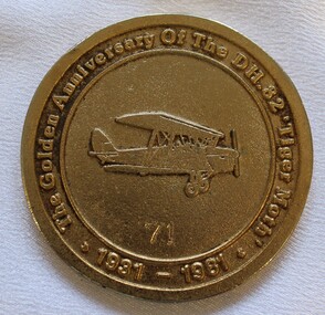
Medal - Antique Aeroplane Association Wodonga Air Show Medallion, 1981
This medallion was produced to commemorate the Antique Aeroplane Association of Australia's annual air show which was held at Wodonga in 1981. It took place at Joe Drage's Air World Museum in Wodonga, Victoria. It recognised the 50th anniversary of the manufacture of the first De Haviland 82 Tiger Moth in 1931. This medallion and 2 other linked medallions were owned by Mr. Clive Cossor. He spent a lot of time at Drage's Historical Aircraft Museum and also helped transport gliders. He was also at the Albury racecourse as a teenager to assist in moving the Uiver when it was forced to land in a storm during the MacRobertson Trophy Air Race from London to Melbourne in October 1934.This medallion is significant as it records an important event recognising aviation in Australia and recognises the development of the Tiger Moth aircraft.A medallion produced to commemorate the Antique Aeroplane Association of Australia's annual air show held at Wodonga in 1981On the front around the medallion surrounding an image of a Tiger Moth aircraft: "The Golden Anniversary of the DH. 82 "Tiger Moth" 1931-1981" Numbered 71 On reverse around the edge: "Antique Aeroplane Association of Australia/ WODONGA 1981". In the centre: "SPONSORS/2AY/ALBURY-WODONGA"aviation history, antique aeroplane association of australia, joe drage airworld, airshow wodonga, dh tiger moth -
 Sunbury Family History and Heritage Society Inc.
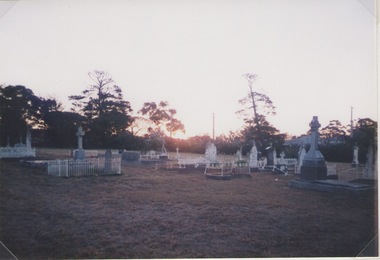
Photograph, Lydia Keyworth, Sunbury Cemetery, March 2001
The photograph of Sunbury Cemetery at sunset was entered into the Photograph Competition organised by the former Sunbury & District Heritage Association in March 2001.In 1862, land set aside in Cemetery Road for the Sunbury Cemetery was laid out in the following Christian denominational groups, Church of England, Roman Catholic, Baptist, Methodist, Presbyterian and Lutheran. Other non-denominational sites were set aside for paupers, heathens, Asians and pagans. Rebecca Jenkinson was the first person to be buried there in 1862. Over the years the size of the cemetery has expanded but it still occupies the original site off Shields Street in Sunbury and the names of the denominational divisions have changed over the years reflect a more inclusive outlook.Sunbury Cemetery replaced other smaller graveyards that were situated in some of the local church grounds and the earlier cemetery that was at The Gap township.A non-digital coloured photograph of a cemetery landscape with a number of old graves scattered across the open space. Some have small fences around them, while others simply display the headstones. There are trees in the background. sunbury cemetery, shields street, cemetery road, sunbury, cemeteries -
 Linton and District Historical Society Inc
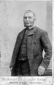
Photograph, Melbourne Photographic Company, Bridge St, Ballarat, Mr W.G Bennett, butcher
William Garnsworthy Bennett was at Linton's Diggings in 1856, when he married Susan Williams. Both had migrated from England. W. G. Bennett established a butcher's shop in Linton Township, and later purchased farming land and other town allotments. William and Susan Bennett had twelve children, eight of whom survived to adulthood. W. G. Bennett was a Trustee of the Linton Town Common, was elected to the Grenville Shire Council in 1871,and founded the Linton Rifle Club. After W. G. Bennett's death in 1903, the butcher's shop was run by the Todd family. William and Susan's daughter Elizabeth (Lizzie) married William Todd in 1882.Sepia photograph of a gentleman with long sideboards, moustache and beard, wearing a suit."Mr W G Bennett, Butcher"william garnsworthy bennett, w. g. bennett [butcher] -
 Melbourne Tram Museum
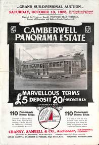
Ephemera - Real estate sale, Cranny Sambell & Co, "Camberwell Panorama Estate", Oct. 1923
Pamphlet advertising the sale of land at the "Camberwell Panorama Estate" - Doncaster and Bulleen Road 13-10-1923. Gives terms of sale, photos showing the views and a nearby shopping centre. Has a large photo of MMTB No. 20 on the front cover. The tramcar is of the Hawthorn Tramways Trust four-door bogie type. MMTB No 20 was an ex-Prahran and Malvern single trucker or small tram A class. Gives details of the 110 lots to be sold, terms, location, and that the tram was proposed to be extended to the corner. This extension took place in 1937. The locality plan shows proposed plans for tram lines in Belmore Road and Burke Road north of Whitehorse Road. Demonstrates the style of land sale pamphlet including the availability of tram services to prospective purchasers.Pamphlet - folded - printed in two colours of cream coloured paper with photographs and plans.has pencil notes on the top of the front page.sale of land, trams, real estate, camberwell panorama estate, east camberwell, doncaster road, bulleen road, tram 20 -
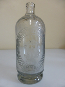 Warrnambool and District Historical Society Inc.
Bottle, J. S Rowley
The making of cordials and aerated waters was an important industry in Warrnambool from the time of the first settlement up to the 1980s. John Rowley was a prominent producer of aerated waters and cordials from 1868 to his death in 1893 (the Warrnambool Steam Aerated Works). He was known for his originality in the production of soft drinks and produced 20 varieties of drinks, including his own Henneberry Wine and Lime Fruit Champagne, both non-alcoholic. In the 1870s he was producing 600 dozen bottles a day and in the 1880s his cordial factory occupied half an acre of land and employed 13 people. He won many awards for his products at local Agricultural Shows. Warrnambool cordial bottles are of considerable significance as examples of an important industry now gone. Rowley is a significant person in the history of 19th century Warrnambool industries and Rowley bottles are of considerable importance, especially this one, made for efferverscent drinks. This is a heavy glass bottle (no stopper) possibly used for hop bitters or ginger wine or some contents that had high efferverscent qualities. The bottle has a heavy indented base. Oval etching ‘J.S.,Rowley Warrnambool’ with ‘Trade Mark’ and monogram. ‘J.R.’ in the centre of the oval. ‘Made in France’ is at the bottom edge of the oval inscriptions.warrnambool, john rowley warrnambool, rowley softdrinks, warrnambool steam aerated works, rowley bottle -
 Eltham District Historical Society Inc
Photograph - Digital Photograph, Marguerite Marshall, Eltham Lower Park, 20 April 2008
Originally a race course, the park has brought the community together with a variety of activities. Published: Nillumbik Now and Then / Marguerite Marshall 2008; photographs Alan King with Marguerite Marshall.; p45 Once used for horse racing, which attracted visitors from Melbourne, the Eltham Lower Park has brought the community together with a wide range of activities. Horse riding is now enjoyed as a recreation in the park as are other sports. The park also includes the Diamond Valley Railway miniature trains and a sanctuary for the rare and vulnerable Eltham Copper Butterfly. Eltham Lower Park, with other parks, forms an almost continuous green band from Eltham’s centre, along the Diamond Creek to the Yarra River.1 Before European settlement the Wurundjeri people met on this land, particularly at the junction of the Diamond Creek with the Yarra River, which they called Birr-arung. This is commemorated by the sculpture, Not just a Pretty Place by Aleks Danko, winner of the 2000 Nillumbik Art in Public Places Award. The first European to settle here was probably Henry Foley, who in 1841 used it as part of his pastoral run. Foley sold his leasehold to Joseph Wilson in 1845, who soon after sold it to Frederick Falkiner. During the 1840s the future park was part of a government square mile (2.6 sqkm) reserve, north of the Yarra, within the Parish of Nillumbik, later named Eltham. Soon the land was used for horse racing after nearby residents cleared ten acres (4ha) in the early 1850s. A three-quarter of a mile (1.2km) race secured the winner the £10 Publican’s Prize. In response to popular demand, the newly formed Eltham District Road Board petitioned the Surveyor General of the Colony of Victoria, in 1856, for 36 acres (14.6ha) of crown land for a racecourse and recreation. By 1858 the Eltham races had become an institution. ‘Many skirmishes occurred and the way home was paved with temptation, with sly-grog for sale.3 In the early 1870s, two jockeys were sons of the police officer in charge of the Eltham Police Station, Miles S Lyons. Another ten acres (4ha) was added to the area in 1866 and 12 acres (4.8ha) – Hohnes Hill – in 1870. In 1866, two acres (0.8ha) on the creek banks became an animal pound with William Walsh the pound keeper in 1870, but this was later incorporated into the park. By 1877 the area was called a public park but horse racing and training continued into the 1920s. In the mid-1900s trotters were trained on a circuit road. In 1953 the Eltham Pony Club was established and used a cross-country course on Hohnes Hill. From the mid 1950s the club held the Eltham Easter Fair at the park, later to include a procession along Main Road from the town centre to the park. The park also attracted picnic parties and campers from the inner suburbs as did Wingrove Park, and businesses catering for visitors, sprang up on the opposite side of Main Road. Bus-loads of school children visited the park for Gould League bird days in the 1960s. In 1979 the Eltham Shire Council bought Lenister Farm, linking the park with the Yarra River. The Lenister Farm wetland includes a bird hide, viewing platform and interpretive signs.5 Pioneer Henry Stooke, later Road Board chairman, bought the 11 acres (4.5ha) - later to become Lenister Farm - from the Crown in 1862. Stooke never lived on this site and the two houses at Lenister Farm were built in the 20th century. Since its formation in 1871, the Council has controlled this crown land, which it named Eltham Park. But in the 1920s Eltham Council bought land near the town centre for a park, which it named Eltham Central Park. To avoid confusion the Council renamed Eltham Park, Eltham Lower Park. Since 2004 the Yarra footbridge has linked the park with the Yarra Valley Metropolitan Park and the Main Yarra Trail.This collection of almost 130 photos about places and people within the Shire of Nillumbik, an urban and rural municipality in Melbourne's north, contributes to an understanding of the history of the Shire. Published in 2008 immediately prior to the Black Saturday bushfires of February 7, 2009, it documents sites that were impacted, and in some cases destroyed by the fires. It includes photographs taken especially for the publication, creating a unique time capsule representing the Shire in the early 21st century. It remains the most recent comprehenesive publication devoted to the Shire's history connecting local residents to the past. nillumbik now and then (marshall-king) collection, eltham lower park, eltham park -
 Eltham District Historical Society Inc
Photograph - Digital Photograph, Alan King, Kinglake National Park, 27 March 2008
Fern gullies around Jehosaphat Gully Covered under National Estate. Published: Nillumbik Now and Then / Marguerite Marshall 2008; photographs Alan King with Marguerite Marshall.; p125 The magnificent Kinglake National Park, fringing Nillumbik’s north, is the largest national park close to Melbourne. Thanks to the vision and hard work of a band of local people, the park was created from what was rapidly becoming degraded land. Seeing a threat to Kinglake’s indigenous flora and fauna, several prominent local people campaigned for a national park, which was established in 1928.1 Since then, the park has grown through donations and acquisitions of land, from around 13,800 acres of land (5585ha) to 22,360 hectares. The Sugarloaf and Everard Blocks – of almost 8000 hectares – stand in Nillumbik and the park extends into Mitchell and Murrundindi Shires and the City of Whittlesea. Mt Everard commemorates William Hugh Everard, State member for Evelyn when the park was established. Before 1928, European settlers had degraded the Kinglake area, which was named after the celebrated English author and lawyer, Alexander William Kinglake. Remains of gold shafts and diggings in the park are reminders of Kinglake’s first settlers, who hoped to strike it rich at the gold diggings. But like other gold fields in this shire, they proved not very lucrative and soon timber cutting replaced mining in importance. However, before long, the accessible timber supply ran out, so in the 1920s agriculture took over – particularly potatoes and berry fruits – which involved large-scale clearing.2 The park’s instigator was retired Melbourne University Professor of Music, William Laver.3 As chair of the Kinglake Progress Association he began negotiations to have crown lands on the southern scarp of the Great Dividing Range reserved as a national park. Even before the park was proclaimed, from 1927, KPA members cut tracks to the major scenic points. Professor Laver was one of several people who gave land for the park, donating around 50 acres (20ha), including the Jehosaphat Gully.4 Laver chaired the park’s first Committee of Management, which raised money to employ a ranger and provide facilities, including tracks and roads for fire protection vehicles, toilets and shelters. The committee charged fees for firewood collection, some grazing of livestock, and visitor entrance, and obtained small State Government and Eltham Shire grants. In 1957 the State Government provided revenue for national parks. Then, in 1975, the State Government took over the management and the Committee of Management became an advisory committee, which disbanded in 1978. Originally, the park covered crown land in the Shires of Eltham and Whittlesea; then Wombelano Falls in Yea and other areas were added. In 1970 the park extended into the Shires of Eltham, Healesville, Whittlesea and Yea.5 Bush fires have been an ongoing problem. In 1939 hundreds of eucalypts and acacias had to be sown around the Jehosaphat Gully to rejuvenate the forest. To manage bushfires, the Committee of Management, then the State Government, worked closely with the Forestry Commission, shire councils and local fire brigades. Early national parks focussed on recreation. But by the 1980s, conservation, education and scientific research became more important, playing a vital role in preserving representative samples of the natural environment. Each year many thousands of people use the park’s extensive network of walking tracks amongst the protected plant and animal life as well as camping, cycling and horse riding. The park, along the slopes of the Great Dividing Range, has lookouts revealing magnificent views of the Melbourne skyline, Port Phillip Bay, the Yarra Valley and the You Yangs. Vegetation in the Masons Falls area includes messmate forest, Austral grass-trees, ferns and Hazel Pomaderris. In spring, orchids, lilies, everlasting daisies, correas, grevillea and heath appear. Around Jehosaphat Gully are wet and dry forest, fern gullies and banksia. Animal life includes wallabies, kangaroos, koalas, echidnas, possums, gliders and bandicoots. Male lyrebirds can be heard mimicking in the Jehosaphat Gully, particularly in the Everard Block in winter.This collection of almost 130 photos about places and people within the Shire of Nillumbik, an urban and rural municipality in Melbourne's north, contributes to an understanding of the history of the Shire. Published in 2008 immediately prior to the Black Saturday bushfires of February 7, 2009, it documents sites that were impacted, and in some cases destroyed by the fires. It includes photographs taken especially for the publication, creating a unique time capsule representing the Shire in the early 21st century. It remains the most recent comprehenesive publication devoted to the Shire's history connecting local residents to the past. nillumbik now and then (marshall-king) collection, kinglake national park, jehosaphat gully -
 The Beechworth Burke Museum
Audio - Oral History, Jennifer Williams, John O'Loughlin, 13 July 2000
John O'Loughlin was born in 1922 in Warracknabeal, Victoria and moved to Beechworth in February 1969. Following a brief time working in the real estate business, John gained employment as a prison officer at Beechworth Gaol. The gaol had initially closed its doors in 1918 but was reopened after the completion of alterations in 1926 as a reformatory prison for habitual male criminals. In his new role, John was able to pursue management in the farming industry, taking trusted prisoners out to a farm on the Wodonga side of Beechworth to work the land. This area was known as The Rockery, a grazing property of two-hundred and eighty acres about two miles north of Beechworth. This work done by the prisoners included timber cutting, land maintenance and the grazing of livestock, mainly Black Poll cattle. The programme was an instrumental component of prisoner rehabilitation, allowing freedom and responsibility. When he retired from his work in 1987, John observed that many improvements had been made towards the living conditions and daily life of the prisoners. This oral history recording was part of a project conducted by Jennifer Williams in the year 2000 to capture the everyday life and struggles in Beechworth during the twentieth century. This project involved recording seventy oral histories on cassette tapes of local Beechworth residents which were then published in a book titled: Listen to what they say: voices of twentieth century Beechworth. The cassette tapes were digitised in July 2021 with funds made available by the Friends of the Burke. John O'Loughlin's account of his life in Beechworth and the local area during the twentieth century is historically and socially significant to the cultural heritage of the region. He details important information surrounding Beechworth Gaol and the daily life of its prisoners; it is a place that still holds significance for the residents of Beechworth today. This oral history account is socially and historically significant as it is part of a broader collection of interviews conducted by Jennifer Williams which were published in the book 'Listen to what they say: voices of twentieth century Beechworth'. While the township of Beechworth is known for its history as a gold rush town, these accounts provide a unique insight into the day-to-day life of the town's residents during the twentieth century, much of which would have been lost if they had not been preserved. This is a digital copy of a recording that was originally captured on a cassette tape. The cassette tape is black with a horizontal white stripe and is currently stored in a clear flat rectangular plastic container. It holds up to forty minutes of recording on each side. John O'Loughlin / beechworth gaol, old beechworth gaol, john o'loughlin, beechworth prison, beechworth, gaol, prisoners, beechworth prison officer, prisoner reform beechworth, the rockery, black poll cattle, daily prison life beechworth, prisoner farmwork, beechworth training prison -
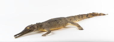 The Beechworth Burke Museum
Animal specimen - Freshwater Crocodile, Trustees of the Australian Museum, 1860-1880
The Freshwater Crocodile can measure up to 3 meters and is generally not considered to be a threat to humans. They reside in Northern Australia, Western Australia and the northern part of Cape York Peninsula in Queensland. They live in freshwater environments and make burrows among the roots of trees which fringe the waters they can be found in. This species of Crocodile mainly feed on invertebrate and vertebrate prey which includes insects, spiders, frogs, fish and small birds and mammals. They are also recognized as "cannibalistic" with the older Freshwater Crocodile occasionally preying on young hatchlings. These crocodiles are known for their "high walk" which they do to move on land. It is named "high walk" because the animal lifts their body off the ground using their long legs for height. They are able to walk considerable distances on land using this technique. In captivity, Freshwater Crocodiles are known to be hostile and aggressive to others of its species. This specimen is part of a collection of almost 200 animal specimens that were originally acquired as skins from various institutions across Australia, including the Australian Museum and the National Museum of Victoria, as well as individuals such amateur anthropologist Reynell Eveleigh Johns between 1860-1880. These skins were then mounted by members of the Burke Museum Committee and put-on display in the formal space of the Museum’s original exhibition hall where they continue to be on display. This display of taxidermy mounts initially served to instruct visitors to the Burke Museum of the natural world around them, today it serves as an insight into the collecting habits of the 19th century.This specimen is part of a significant and rare taxidermy mount collection in the Burke Museum. This collection is scientifically and culturally important for reminding us of how science continues to shape our understanding of the modern world. They demonstrate a capacity to hold evidence of how Australia’s fauna history existed in the past and are potentially important for future environmental research. This collection continues to be on display in the Museum and has become a key part to interpreting the collecting habits of the 19th century.The Freshwater Crocodile has a slender snout which is much smaller and thinner than its Saltwater counterpart. This specimen has dark grey and brown colouring with the darker colours concentrated around the face and upper torso of the Crocodile. There are darker stripes along the tail which features triangular scales and is long in length. The teeth are visible and bright yellow glass has been used to replace the eyes of this particular specimen. The crocodile has long but thin limbs which protrude from the sides of the body.taxidermy mount, taxidermy, animalia, burke museum, beechworth, australian museum, skin, reynell eveleigh johns, crocodile, freshwater crocodile, johnstone's crocodile -
Glen Eira Historical Society
Letter - Ristori Estate, Lots 20 and 21
11 documents about the sales (31/05/1919 initially; then March 1920) of Lots 20 and 21 Ristori Estate: 1/3 contracts of sale to Edwin Percy Smith from ME Coppel. 2/2 receipts from Yeo Crosthwaite & Co. to E.P. Smith dated 26/11/1919 and 24/02/1920 for quarterly payments. 3/1 working copy of contract of sale dated March 1920 from E.P.Smith to Thomas Herbert Evans Putt. 4/1 handwritten letter dated 09/08/1920 from E.P. Smith to Mr P. St John Hall Esq asking for advice about transfer papers for the Ristori Estate. 5/1 typed letter dated 16/08/1920 from Yeo Crosthwaite & Co to E.P. Smith asking for signing return of Alienation Notice. 6/1 handwritten letter dated 23/08/1920 from E.P. Smith to Mr P. St John Hall asking whether he or Mr Putt should sign papers. 7/1 typed letter dated 07/09/1920 from Yeo Crosthwaite & Co. to E.P. Smith asking for return of Land Tax Alienation Notice. 8/1 handwritten note dated 18/09/1920 from (likely) Mr Putt to Yeo Crosthwaite & Co returning Land Tax Notice & further Notice of Sale; 9/Business Card (handwritten) for Thomas Herbert & Evan Putt, Builder, Inkerman Road, Caulfieldripponlea, smith edwin percy, inkerman road, ristori estate, glenhuntly rd, glen huntly road, correspondence, auctions, putt thomas herbert evans, builders, yeo crosthwaite & co., receipts, elsternwick, coppel m.e, auctioneers -
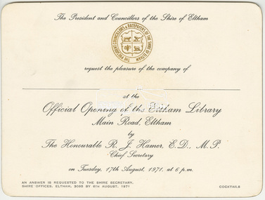 Eltham District Historical Society Inc
Invitation, The President and Councillors of the Shire of Eltham request the pleasure of the company of __ to the Official opening of the Eltham Library, Main Road, Eltham by The Honourable R.J. Hamer, E.D., M.P. Chief Secretary on Tuesday, 17th August, 1971, at 6 p.m, 1971
The Eltham Library was located at the southern end of the newly constructed southern wing of the Shire Offices at 895 Main Road. The first dedicated library in the shire was the Children's Library built by the Eltham War Memorial Trust (now the Eltham War Memorial Hall). Funds were raised by volunteers to purchase books, the land and construct the building. This library initially opened in the Eltham Public Hall on the corner of Main Road and Arthur Street around 1948. The Children’s Library building was opened in 1961 but the transfer to the Eltham Council of the War Memorial Trust land and buildings in 1965 saw the closure of the children's library, which held over 2,000 books that were then transferred to all the schools in the shire which had participated in the monthly book exchange of boxes of books by use of the railways, bus companies and private cars. In late 1966 the children’s library service was integrated into the Heideberg Regional Library Service and the building was officially renamed the Eltham War Memorial Hall. The Brinkkotter house in Dudley Street became the first of the general library services in Eltham with shelving from the old Heidelberg City Library, staff borrowed form the Heidelberg Library and some use of the 1941 Shire Office in Main Road. By 1971 the 1964 Shire Office had the southern extension added and the Library was located on the lower level with Engineering and Planning on the level above. By 1986 this library was experiencing overcrowding from lack of space and equipment needs. With Federal Government assistance, Council was able to design and build a new library which was located in the Eltham Common and opened in May 1994.Background workings for the funding of a Public Hall at Eltham. The funding was provided by public subscription and the money loaned to Council to build the hall. The hall was part of the new Eltham Shire offices located at the corner of Main Road and Arthur Street. A similar funding approach was used a few years later to provide for the Eltham War Memorial located on the opposite side of Main Road.Printed card 10.5 x 15.7 cmeltham library, eltham library opening, eltham shire council, opening ceremony, r.j. hamer, shire of eltham -
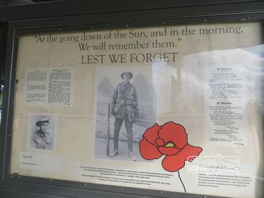 Eltham District Historical Society Inc
Photograph, Liz Pidgeon, Moor-Rul Viewing Platform Panel: Lest We Forget, 10 August 2016
Includes photograph of WW1 local enlistment John Bell. The Moor-Rul Viewing Platform, part of the Kangaroo Ground War Memorial Park opened in April 2007. Eight double-sided interpretation panels on the Moor-rul viewing platform highlight the area's Aboriginal and European history of the area and also details of local geology, flora and fauna. These panels feature high quality graphic design and professionally written text. The subjects covered are: ''Womin Je Ka" Welcome The Kulin Nation Singing, Dancing, Ceremony, Celebration This Country, My Home The Highland Taken Auld Lang Syne "Same Land Different Views" Working the Land Food from the Earth or "Earth's Harvest" Lest We Forget, "And with the going down of the Sun .... (3 panels) This Black Earth Those other indigenous inhabitants - Kangaroo Ground's Wildlife Silent Witnesses - Kangaroo Ground's White Manna Gums Belonging A Place of Reverence and A Tower of Strength Souce: EDHS Newsletter No 173 March 2007. As part of a program to acknowledge the Anzac Centenary Nillumbik Shire Council partnered with Yarra Plenty Regional Library to provide a bus tour with commentary of local sites of significance: Shire of Nillumbik World War One Memorials tour, 10 August 2016. These included Eltham township, the Shire of Eltham War Memorial at Kangaroo Ground, Christmas Hills war memorial, Hurstbridge memorial recreation park and finshed at Eltham Library to view the Writing the War exhibtion at Eltham Library Community Gallery.Born Digitalworld war 1, war memorials, shire of nillumbik, moor-rul viewing platform, interpretation panel, interpretative signage, lest we forget, shire of eltham war memorial, john bell, display panel -
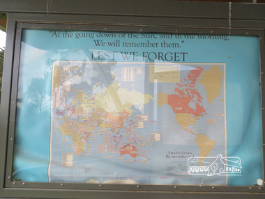 Eltham District Historical Society Inc
Photograph, Liz Pidgeon, Moor-Rul Viewing Platform Panel: Lest We Forget, 10 August 2016
Coloured map of the world on blue including the words for the "Lest We Forget" lament. The Moor-Rul Viewing Platform, part of the Kangaroo Ground War Memorial Park opened in April 2007. Eight double-sided interpretation panels on the Moor-rul viewing platform highlight the area's Aboriginal and European history of the area and also details of local geology, flora and fauna. These panels feature high quality graphic design and professionally written text. The subjects covered are: ''Womin Je Ka" Welcome The Kulin Nation Singing, Dancing, Ceremony, Celebration This Country, My Home The Highland Taken Auld Lang Syne "Same Land Different Views" Working the Land Food from the Earth or "Earth's Harvest" Lest We Forget, "And with the going down of the Sun .... (3 panels) This Black Earth Those other indigenous inhabitants - Kangaroo Ground's Wildlife Silent Witnesses - Kangaroo Ground's White Manna Gums Belonging A Place of Reverence and A Tower of Strength Souce: EDHS Newsletter No 173 March 2007. As part of a program to acknowledge the Anzac Centenary Nillumbik Shire Council partnered with Yarra Plenty Regional Library to provide a bus tour with commentary of local sites of significance: Shire of Nillumbik World War One Memorials tour, 10 August 2016. These included Eltham township, the Shire of Eltham War Memorial at Kangaroo Ground, Christmas Hills war memorial, Hurstbridge memorial recreation park and finshed at Eltham Library to view the Writing the War exhibtion at Eltham Library Community Gallery. Born Digitalworld war 1, war memorials, shire of nillumbik, moor-rul viewing platform, kangaroo ground, shire of eltham war memorial, interpretative signage, interpretation panel, map, display panel -
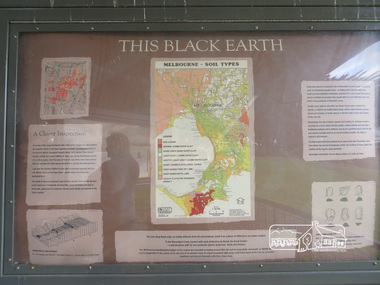 Eltham District Historical Society Inc
Photograph, Liz Pidgeon, Moor-Rul Viewing Platform Panel: This Black Earth, 10 August 2016
"Melbourne soil types" The Moor-Rul Viewing Platform, part of the Kangaroo Ground War Memorial Park opened in April 2007. Eight double-sided interpretation panels on the Moor-rul viewing platform highlight the area's Aboriginal and European history of the area and also details of local geology, flora and fauna. These panels feature high quality graphic design and professionally written text. The subjects covered are: ''Womin Je Ka" Welcome The Kulin Nation Singing, Dancing, Ceremony, Celebration This Country, My Home The Highland Taken Auld Lang Syne "Same Land Different Views" Working the Land Food from the Earth or "Earth's Harvest" Lest We Forget, "And with the going down of the Sun .... (3 panels) This Black Earth Those other indigenous inhabitants - Kangaroo Ground's Wildlife Silent Witnesses - Kangaroo Ground's White Manna Gums Belonging A Place of Reverence and A Tower of Strength Souce: EDHS Newsletter No 173 March 2007. As part of a program to acknowledge the Anzac Centenary Nillumbik Shire Council partnered with Yarra Plenty Regional Library to provide a bus tour with commentary of local sites of significance: Shire of Nillumbik World War One Memorials tour, 10 August 2016. These included Eltham township, the Shire of Eltham War Memorial at Kangaroo Ground, Christmas Hills war memorial, Hurstbridge memorial recreation park and finshed at Eltham Library to view the Writing the War exhibtion at Eltham Library Community Gallery.Born Digitalshire of nillumbik, moor-rul viewing platform, interpretative signage, interpretation panel, display panel -
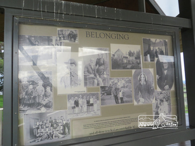 Eltham District Historical Society Inc
Photograph, Liz Pidgeon, Moor-Rul Viewing Platform Panel: Belonging, 10 August 2016
Collage of black and white historical photographs of people. The Moor-Rul Viewing Platform, part of the Kangaroo Ground War Memorial Park opened in April 2007. Eight double-sided interpretation panels on the Moor-rul viewing platform highlight the area's Aboriginal and European history of the area and also details of local geology, flora and fauna. These panels feature high quality graphic design and professionally written text. The subjects covered are: ''Womin Je Ka" Welcome The Kulin Nation Singing, Dancing, Ceremony, Celebration This Country, My Home The Highland Taken Auld Lang Syne "Same Land Different Views" Working the Land Food from the Earth or "Earth's Harvest" Lest We Forget, "And with the going down of the Sun .... (3 panels) This Black Earth Those other indigenous inhabitants - Kangaroo Ground's Wildlife Silent Witnesses - Kangaroo Ground's White Manna Gums Belonging A Place of Reverence and A Tower of Strength Souce: EDHS Newsletter No 173 March 2007. As part of a program to acknowledge the Anzac Centenary Nillumbik Shire Council partnered with Yarra Plenty Regional Library to provide a bus tour with commentary of local sites of significance: Shire of Nillumbik World War One Memorials tour, 10 August 2016. These included Eltham township, the Shire of Eltham War Memorial at Kangaroo Ground, Christmas Hills war memorial, Hurstbridge memorial recreation park and finshed at Eltham Library to view the Writing the War exhibtion at Eltham Library Community Gallery.Born Digitalshire of nillumbik, moor-rul viewing platform, kangaroo ground, interpretative signage, interpretation panel, display panel -
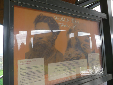 Eltham District Historical Society Inc
Photograph, Liz Pidgeon, Moor-Rul Viewing Platform Panel: Womin Je Ka "Welcome", 10 August 2016
Welcome panel including information on William Barak. The Moor-Rul Viewing Platform, part of the Kangaroo Ground War Memorial Park opened in April 2007. Eight double-sided interpretation panels on the Moor-rul viewing platform highlight the area's Aboriginal and European history of the area and also details of local geology, flora and fauna. These panels feature high quality graphic design and professionally written text. The subjects covered are: ''Womin Je Ka" Welcome The Kulin Nation Singing, Dancing, Ceremony, Celebration This Country, My Home The Highland Taken Auld Lang Syne "Same Land Different Views" Working the Land Food from the Earth or "Earth's Harvest" Lest We Forget, "And with the going down of the Sun .... (3 panels) This Black Earth Those other indigenous inhabitants - Kangaroo Ground's Wildlife Silent Witnesses - Kangaroo Ground's White Manna Gums Belonging A Place of Reverence and A Tower of Strength Souce: EDHS Newsletter No 173 March 2007. As part of a program to acknowledge the Anzac Centenary Nillumbik Shire Council partnered with Yarra Plenty Regional Library to provide a bus tour with commentary of local sites of significance: Shire of Nillumbik World War One Memorials tour, 10 August 2016. These included Eltham township, the Shire of Eltham War Memorial at Kangaroo Ground, Christmas Hills war memorial, Hurstbridge memorial recreation park and finshed at Eltham Library to view the Writing the War exhibtion at Eltham Library Community Gallery. Born Digitalshire of nillumbik, memorial park, kangaroo ground, interpretative signage, indigenous history, moor-rul viewing platform, william barak, display panel -
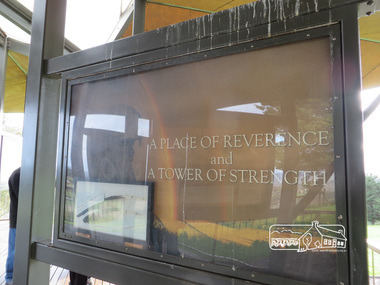 Eltham District Historical Society Inc
Photograph, Liz Pidgeon, Moor-Rul Viewing Platform Panel: A Place of Reverence and a Tower of Strength, 10 August 2016
The Moor-Rul Viewing Platform, part of the Kangaroo Ground War Memorial Park opened in April 2007. Eight double-sided interpretation panels on the Moor-rul viewing platform highlight the area's Aboriginal and European history of the area and also details of local geology, flora and fauna. These panels feature high quality graphic design and professionally written text. The subjects covered are: ''Womin Je Ka" Welcome The Kulin Nation Singing, Dancing, Ceremony, Celebration This Country, My Home The Highland Taken Auld Lang Syne "Same Land Different Views" Working the Land Food from the Earth or "Earth's Harvest" Lest We Forget, "And with the going down of the Sun .... (3 panels) This Black Earth Those other indigenous inhabitants - Kangaroo Ground's Wildlife Silent Witnesses - Kangaroo Ground's White Manna Gums Belonging A Place of Reverence and A Tower of Strength Souce: EDHS Newsletter No 173 March 2007. This panel includes a frame of an eagle feather. See ID 02224-47 As part of a program to acknowledge the Anzac Centenary Nillumbik Shire Council partnered with Yarra Plenty Regional Library to provide a bus tour with commentary of local sites of significance: Shire of Nillumbik World War One Memorials tour, 10 August 2016. These included Eltham township, the Shire of Eltham War Memorial at Kangaroo Ground, Christmas Hills war memorial, Hurstbridge memorial recreation park and finshed at Eltham Library to view the Writing the War exhibtion at Eltham Library Community Gallery.Born Digitalshire of nillumbik, kangaroo ground, moor-rul viewing platform, interpretative signage, interpetation panel, display panel -
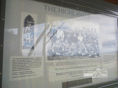 Eltham District Historical Society Inc
Photograph, Liz Pidgeon, Moor-Rul Viewing Platform Panel: The Highland Taken, 10 August 2016
"The Scots were the first Europeans to farm this place". The Moor-Rul Viewing Platform, part of the Kangaroo Ground War Memorial Park opened in April 2007. Eight double-sided interpretation panels on the Moor-rul viewing platform highlight the area's Aboriginal and European history of the area and also details of local geology, flora and fauna. These panels feature high quality graphic design and professionally written text. The subjects covered are: ''Womin Je Ka" Welcome The Kulin Nation Singing, Dancing, Ceremony, Celebration This Country, My Home The Highland Taken Auld Lang Syne "Same Land Different Views" Working the Land Food from the Earth or "Earth's Harvest" Lest We Forget, "And with the going down of the Sun .... (3 panels) This Black Earth Those other indigenous inhabitants - Kangaroo Ground's Wildlife Silent Witnesses - Kangaroo Ground's White Manna Gums Belonging A Place of Reverence and A Tower of Strength Souce: EDHS Newsletter No 173 March 2007. As part of a program to acknowledge the Anzac Centenary Nillumbik Shire Council partnered with Yarra Plenty Regional Library to provide a bus tour with commentary of local sites of significance: Shire of Nillumbik World War One Memorials tour, 10 August 2016. These included Eltham township, the Shire of Eltham War Memorial at Kangaroo Ground, Christmas Hills war memorial, Hurstbridge memorial recreation park and finshed at Eltham Library to view the Writing the War exhibtion at Eltham Library Community Gallery.Born Digitalshire of nillumbik, kangaroo ground, moor-rul viewing platform, interpretative signage, interpretation panel, indigenous history, display panel, early settlers -
Glen Eira Historical Society
Document - GLEN HUNTLY (HISTORY OF)
This file contains one item: 1/A loose-leaf, 23-page document titled ‘The History of Glen Huntly’, by Alfred R. Jones, dated 20/06/1991, describing the history of the suburb. The author has drawn heavily from the 4 sources noted in the bibliography. Subjects covered include the ship the suburb is named after, the suburb’s State School, the suburb’s churches, the Rosstown Railway and Sugar Mill, the origin of the name of Carnegie, the suburb’s aerodrome, and the beautification of the Glen Huntly Shopping Centre. The final 12 pages consist of 9 appendices relating to the aforementioned subjects. Appendix A is a typewritten letter from Ron McLeod, secretary of the Place Names Committee, to Mr. D. R. Aylen, CEO of the City of Caulfield, notifying the latter of the alteration of the name ‘Glenhuntly’ to ‘Glen Huntly’. Appendix B is a list of the ministers of St. David’s Uniting Church from its formation in 1916 to the present. Appendix C identifies the persons portrayed in St. David’s stained glass windows. Appendix D is a poster announcing the auction of 41 blocks of land between Hawthorn and Bambra Road formerly owned by William Ross, plus a map identifying said land blocks and anither fir locality. Appendix E is an A4 plan of the Rosstown Railway. Appendix F is a drawing of the Rosstown Sugar Mill. Appendix G is a poem titled ‘The Swagman’s Retreat’, by Herb Arnott, about the failure of the Mill. Appendix H is a map of Caulfield’s horse tramways plus a list of opening and closing dates. Appendix J is a list of streets explaining the meanings of their names.glen huntly, glenhuntly, local history, ‘glen huntly’ (ship), ‘glen huntlely’ (ship), quarantine stations, glen huntly road, lake street, mernda avenue, glen huntly state school no. 3703, ormond francis, ormond, garden avenue, grange road, churches, congregational church, glen huntly presbyterian church, st. david’s, st. david’s uniting church, anglican church, jenkin william ‘boss’, methodist church, wattle avenue, smith a. w. mr., glen huntly post office, glen huntly road, king f. l. mr., uniting church, child care centre, presbyterian church of eastern australia, glen huntly methodist church, sun aria, miller mary, stained glass, phrenologists, trinity congregational church, primitive methodists, ‘the victorian independent’, mercy mr., greek orthodox original old calendar church, wanalta road, salvation army, halls, myrtle street, catholic church, st. anthony’s roman catholic church, foundation stones, neerim road, mannix archbishop, st. agnes’ anglican church, booran road, sunday schools, clergy residences, ‘see’ anglican news magazine, lees archbishop, booth archbishop, glen huntly presbyterian church, el nido grove, tennis courts, bollard v. w. right rev., waratah avenue, royal avenue, munster avenue, james street, rothschild street, peace memorial organ, singers, bremner marie, scotland betty, carden joan, rosstown railway, south caulfield, plants, marata road, curraweena road, bambra road, ross william murray, ross leila, ross constance, vautin constance, ‘the grange’, north road, leila road, wild cherry road, caulfield roads board, elsternwick, land sales, sugar mills, koornang road, woornack road, elsternwick railway station, riddell parade, clarence street, dover street, oakleigh road, murrumbeena crescent, carlisle crescent, railways, trains, parks and reserves, caulfield council, sussex street, caulfield city council, swamps, rosstown sugar mill, rosstown estate, ‘the swagman’s retreat’, arnott herb, rosstown, carnegie, ‘ross’s folly’, carnegie andrew, rosstown hotel, dandenong road, rosstown road, rosstown plate horse race, caulfield racecourses, ames avenue, rosstown court, hostels, murrumbeena, cinemas, innovations (cabinetry film), films, music, pianos, manchester grove, safeway store, squash courts, airports, lord reserve, aeroplanes, air navigation act 1921, neville street, larkin sopwith aviation company of australasia, lyons street, morgan street, bookmakers, nightsoil, poultry, weatherboard buildings, glen huntly railway station, rosedale avenue, rifle clubs, scout groups, 1st glen huntly troop, ana, dowding jack mr., glen huntly infant welfare and family planning clinic, vermador private hospital, watson grove, rowlands (drapers), bones plant nursery, caulfield railway station, bridges, trams, horse tramways, glen eira road, elsternwick railway station, kooyong road, aboriginal peoples, truganini road, hannan lyn mrs. (urban planning officer), glen huntly shopping centre, sculptures, street beautification scheme, “flying the yellow flag”, moore olive, “return to rosstown”, jowett d. f., weickhardt i. s., “from sand swamp and health”, murray peter r., wells john c., caulfield historical society, newsletters, place names committee, mcleod ron, aylen d. r. mr., jones hugh rev., king joseph, scarfe james, vertigan sidney, vertigan earle, rance victor, flavell cameron, denholm robin, moorhead ken, taliai siupeli, eccles james leslie, little agnes, hutchins william r., dickie may a., gordon ivey agnes, theobald a. a. mrs., brownbill lloyd norman, ash georgette, land sales, auctions, messrs. crews & arkle, street names -
 City of Moorabbin Historical Society (Operating the Box Cottage Museum)
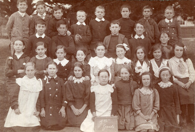
Photograph, Black & White, Cheltenham State School Grade 5 1910, c1910
1855 Stephen Charman donated land to the Methodist Church so that a School could be established to educate the children of the early settler market gardeners and farmers in the Cheltenham area . Education was valued by the general community and as well as schools they established mechanics Institutes and Libraries in Moorabbin Shire. Cheltenham State School No. 84 was among the first schools in Melbourne. Stephen Charman, 1821-1906 a market gardener, donated land for the first Methodist Chapel, Cemetery and School in Charman Rd Cheltenham 1855. The enrolment was 36 pupils with Mr Frederick Meeres as Teacher. 1863 the school is called Beaumaris Common School No 84 with 70 pupils and Walter Meeres as Teacher. 1869 another 2 acres in Charman Road were granted by the Education Board and brick building built . 1872 State School 84 Beaumaris was increasing enrollments and 1878 a new brick school was built to accommodate 174 pupils and the name changed to Cheltenham State School No.84 1894 Mentone State School No.2950 amalgamated with Cheltenham SS No.84. 1910 the buildings were in disrepair, overcrowding was increasing and renovations were made 1912 with further additions in 1925 and 1937. Post WW11 extra prefabricated Classrooms were added as enrollment increased to 1038 in 1955.. Cheltenham East State School 4754 was opened as housing development spread over the City of Moorabbin . (J.Larson Sandringham HS) The names written on the photograph show the pupils belong to many early settler families.1855 Stephen Charman donated land to the Methodist Church so that a School could be established to educate the children of the early settler market gardeners and farmers in the Cheltenham area . Education was valued by the general community and as well as schools they established mechanics Institutes and Libraries in Moorabbin Shire. Cheltenham State School No. 84 was among the first schools in Melbourne. These pupils belong to the early settler families in Moorabbin ShireBlack & White photograph of pupils in Grade 5 at Cheltenham State School No 84 c1910Front ; 1st Rodda - Millege - Lemkie, Orr / 2nd Moorhouse, McGregor, Marriott, N. Bodley, E. Howard / 3rd; K.Whelan,E.Ould, D.Kilburn, Moorhouse, Roberts, - - Tilly - Teagal,Miller, Primer. - Martin, Caulfield Back Mrs Taylorcheltenham primar school, city of moorabbin, county of bourke, moorabbin roads board, parish of moorabbin, shire of moorabbin, henry dendy's special survey 1841, were j.b., bent thomas, o'shannassy john, king richard, charman stephen, highett william, ormond francis, maynard dennis, cheltenham state school no.84, methodist chapel cheltenham, methodist school cheltenham, beaumaris west state school, meeres frederick, meeres walter, education, early settlers, cancel -
 Surrey Hills Historical Society Collection
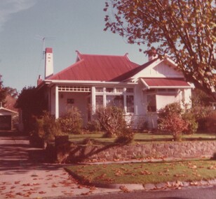
Photograph, 5 York Street, Mont Albert, May 1985 (1), 1985
This is the home of Ernest Augustus Young (1891-1985) and Ruby Nichell Whitby (1892-1984) and their son Ernest Lance Young. Lance was born 24 March 1915 in Surrey Hills; after he married Beryl Mair. Electoral roll for 1937 gives the house name as 'Whitby Lodge'. Ernest and Ruby also had twins Clive and James who died in infancy. Buried at Box Hill Cemetery - M-*-0867 (family plot) This is part of a large collection relating to the Mair, Deakin and Young families. REF: Memoir of Laurie Newton (nee Young) - Her grandfather bought the land and had the house built. She remembers it as having pressed ceilings in some rooms and ornate fireplaces and tiles and leadlight windows in some rooms and doors with leadlight panels. Her grandfather was a keen gardener with an ornamental front garden and many vegetables and fruit trees in the back yard. Her grandfather sold the adjoining block (No 3 York Street), which had been used for growing flowers and vegetables, to John and Edna Jean. Reid. She also remembered that he extended the house and divided it into 2 flats, renting out the northern side for 20 years. Sold by Jellis Craig on 24 December 2010 - With formal living, dining, 3 bedrooms, 2 bathrooms, garage/ample OSP. Land: 18.2m x 40.8m (60' x 134') approx. Large 2 storey house replaced the house.Colour photo of the street view of 5 York Street, Mont Albert. The house is Edwardian in style, constructed from weatherboard painted white with a red corrugated iron roof with simple finials. There is a small veranda with simple fretwork, lead-light feature windows to one, possibly two front rooms, one of which has a bay window. There is a garage set back at the side of the house with a concrete driveway on the south side of the house towards Mont Albert Road. The fence is low and constructed from roughly faced stone. The garden contains mature shrubs.In blue biro on rear: "1985 / POP'S" ; "5 YORK ST / E.A. YOUNG". Red photographic processing stamp "PROCESSED BY / KODAK / MAY 85M"ernest augustus young, ruby nichell whitby, ruby nichell young, ernest lance young, box hill cemetery, whitby lodge, house names, mont albert -
 Surrey Hills Historical Society Collection
Photograph, 5 York Street, Mont Albert, May 1985 (2), 1985
This is the home of Ernest Augustus Young (1891-1985) and Ruby Nichell Whitby (1892-1984) and their son Ernest Lance Young. Lance was born 24 March 1915 in Surrey Hills; after he married Beryl Mair. Electoral roll for 1937 gives the house name as 'Whitby Lodge'. Ernest and Ruby also had twins Clive and James who died in infancy. Buried at Box Hill Cemetery - M-*-0867 (family plot) This is part of a large collection relating to the Mair, Deakin and Young families. REF: Memoir of Laurie Newton (nee Young) - Her grandfather bought the land and had the house built. She remembers it as having pressed ceilings in some rooms and ornate fireplaces and tiles and leadlight windows in some rooms and doors with leadlight panels. Her grandfather was a keen gardener with an ornamental front garden and many vegetables and fruit trees in the back yard. Her grandfather sold the adjoining block (No 3 York Street), which had been used for growing flowers and vegetables, to John and Edna Jean. Reid. She also remembered that he extended the house and divided it into 2 flats, renting out the northern side for 20 years. Sold by Jellis Craig on 24 December 2010 - With formal living, dining, 3 bedrooms, 2 bathrooms, garage/ample OSP. Land: 18.2m x 40.8m (60' x 134') approx. Large 2 storey house replaced the house. Adjacent house (No 7 York Street) has been renovated. Colour photo of a rear view of 5 York Street, Mont Albert. Only part of the house can be seen but part of the roof of the house next door and brick and stucco chimneys can be seen. There is a greenhouse between these 2 properties.Red photographic processing stamp "PROCESSED BY / KODAK / MAY 85M"ernest augustus young, ruby nichell whitby, ruby nichell young, ernest lance young, box hill cemetery, whitby lodge, house names, mont albert -
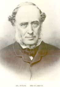 Port Fairy Historical Society Museum and Archives
Photograph, Cr J Ritchie Shire of Belfast President1866-67 1869-70
Cr J Ritchie came from Scotland at Hobart in 1833 having been 9 months on the outward journey. he took up land at South Esk and remained there for 6 years.later on advice of the Henry brothers he came to Victoria and after a preliminary inspection of the land charted the brig “William” and with all of his possessions, including 2000 sheep and two servants he arrived in Portland Bay in January 1840 and as he already held a squatting licence No 230 became a settler in the district. he moved along the coast toward Goose Lagoon but due to a drought the water had dried up and forced him to move further eastward to the Upeer Hopkins but the lack of any but brackish water he was forced to return to Aringa. Aringa comprised of 26,000 acres between the Shaw and Moyne Rivers, 640 acres became freehold at one pound and acre with the right to take up leasehold at a low rate according to the number of stock. At Aringa he designed and built his first home part of which still stands today. He married Sarah Elizabeth Davis in 1852 at Weerongurt Station (Mr John Cox’s property). Mrs Ritchie died in 1920. he was elected Shire of Belfast President for the periods of 1866-67 and 1869-70 John had originally chosen to practice law as his vocation in Scotland but abandoned law for the open air life and died at the age of 86 years in 1887 elected Shire of Belfast President for the periods of 1866-67 and 1869-70Black and white portrait photograph Cr J Ritchie 1866-67 1869-70belfast, president, council, portrait, government, shire, municipal, local-government -
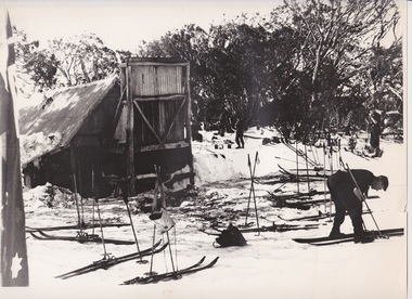 Falls Creek Historical Society
Photograph - At Wallace' s Hut
Wallace's Hut is the oldest surviving cattlemen's hut on the High Plains, built in 1889 by the three Wallace brothers - Arthur, William and Stewart. Their father David bought land at Kergunyah as well as grazing land on the banks of the Kiewa River, North East Victoria. Once the boys were old enough, the family followed the local squatters’ custom of taking their cattle up to the mountains for the spring and summer to fatten the mob, at the same time resting their home pastures. They decided to build a hut where they could shelter from the extreme mountain weather. The timber was cut from the forest about four hundred metres east of the hut, and the hearth stone was dragged in from Pretty Valley. The chimney had a base of rubble and above this iron sheeting on a timber frame. The slab walls were lined with hessian and later with tar-paper, and inside there was a bush table, sleeping platform and a rustic fire-side settle. The hut nestled among snow gums sheltered by a rocky outcrop. The names of the Wallace brothers were burnt into the tie-beams of the roof and at the back of the mantelpiece. The Wallace family’s lease expired in the late 1930s and the hut was bought by the State Electricity Commission to house staff on the High Plains and it became the first home of Toni and Skippy St. Elmo. The SEC covered the old shingles with iron, and later on the walls and chimney as well, and they added a lean-to. Wallace’s Hut is now owned by the Crown and maintained by Parks Victoria. It is on the Historic Buildings Register and is classified by the National Trust.This image is significant because it depicts an important heritage-listed structure and refuge for cattlemen and other travellers in Victoria's High Country.A black and white photograph of a skier outside of Wallace's Hut. Several sets of skis and poles are standing around and other skiers are in the background.wallace's hut, toni and skippy st. elmo, high country huts -
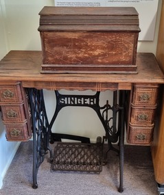 Wodonga & District Historical Society Inc
Machine - Singer Treadle Sewing Machine, The Singer Manufacturing Company, c1890
The Wodonga Historical Society Haeusler Collection provides invaluable insight into life in late nineteenth and early twentieth century north east Victoria. The collection comprises manuscripts, personal artefacts used by the Haeusler family on their farm in Wodonga, and a set of glass negatives which offer a unique visual snapshot of the domestic and social lives of the Haeusler family and local Wodonga community. The Haeusler family migrated from Prussia (Germany) to South Australia in the 1840s and 1850s, before purchasing 100 acres of Crown Land made available under the Victorian Lands Act 1862 (also known as ‘Duffy’s Land Act’) in 1866 in what is now Wodonga West. The Haeusler family were one of several German families to migrate from South Australia to Wodonga in the 1860s.| This sewing machine belonged to Isla Ilma Margaret Ernestine neeTasker, mother of Alfred Haeusler. Singer was first established as I. M. Singer & Co. in 1851 by Isaac Merritt Singer with New York lawyer Edward C. Clark. Best known for its sewing machines, it was renamed Singer Manufacturing Company in 1865, then the Singer Company in 1963. The Singer company began to market its machines internationally in 1855 and won first prize at the Paris world's fair that year. They had offices established in both Sydney and Melbourne by the mid-1960s. The company demonstrated the first workable electric sewing machine in 1910. Singer was also a marketing innovator and a pioneer in promoting the use of instalment payment plans, making their machines more affordable for many people. This item is from the Hauseler Collection which documents social life of early settlers in the Wodonga community.Singer "Coffin top" treadle sewing machine with extension table. The machine is mainly black and silver metal but is extensively decorated with coloured decals. The decorations on this machine features a pheasant design which also helps to date the machine as it was only used from 1890 to 1915. The sewing machine is set into a wooden table with and extension leaf and 6 drawers, 3 on either side. The frame and treadle mechanism are iron with a thin leather belt to drive the mechanism. The "coffin" shaped top sits over the machine to protect it when not in use and is easily removed. The extension leaf provides a larger working surface and folds down when not in use. The Singer logo attached to the front of the machine features a needle, shuttle and thread.On metal base plate: "PATENTED /DEC 5 -1882/ MARCH 20 - 1883/ AUG - 21 1888. Model no: L6485622 Along top of machine: "The Singer Manufacturing Co." Front right: Singer Company Logohaeusler family, wodonga pioneers, sewing machines, singer sewing macnine -
 Wodonga & District Historical Society Inc
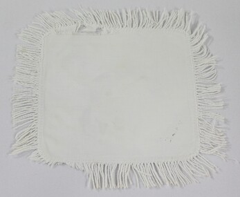
Textile - Haeusler Collection White Cotton Doily with Hand Stitched Fringe c.1920s
The Wodonga Historical Society Haeusler Collection provides invaluable insight into life in late nineteenth and early twentieth century north east Victoria. The collection comprises manuscripts, personal artefacts used by the Haeusler family on their farm in Wodonga, and a set of glass negatives which offer a unique visual snapshot of the domestic and social lives of the Haeusler family and local Wodonga community. The Haeusler family migrated from Prussia (Germany) to South Australia in the 1840s and 1850s, before purchasing 100 acres of Crown Land made available under the Victorian Lands Act 1862 (also known as ‘Duffy’s Land Act’) in 1866 in what is now Wodonga West. The Haeusler family were one of several German families to migrate from South Australia to Wodonga in the 1860s. The textiles in the Haeusler collection belonged to Ilma Margaret Ernestine Haeusler (née Tasker), born in 1900 in Tallangatta. These textiles were handmade by Ilma between 1919 and 1928 for use in the family home during her marriage to Louis Alfred Haeusler (b.1878). Ilma died in childbirth in 1928, leaving one surviving son, John Alfred Lyell (b.1922). This textile is one of the many domestic objects in the Haeusler Collection that represent family and home life in early twentieth century Wodonga. In the nineteenth and early twentieth century prior to the mass production of clothing and textiles, needlework, alongside motherhood, was the defining work of women. Hand sewing and embroidery was central in the everyday lives and domestic roles of women. The item is handmade and unique, with well documented provenance. It forms part of a significant and representative historical collection which reflects the local history of Wodonga. It contributes to our understanding of domestic and family life in early twentieth century Wodonga, as well as providing interpretative capacity for themes including local history, social history, and women’s history.Hand made white cotton doily with hand stitched cotton fringe c.1919-1928textiles, sewing, handiwork, women's history, domestic, craft, family, wodonga, haeusler collection, haeusler -
 Wodonga & District Historical Society Inc
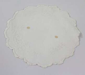
Textile - Haeusler Collection Embroidered Doily c.1920s
The Wodonga Historical Society Haeusler Collection provides invaluable insight into life in late nineteenth and early twentieth century north east Victoria. The collection comprises manuscripts, personal artefacts used by the Haeusler family on their farm in Wodonga, and a set of glass negatives which offer a unique visual snapshot of the domestic and social lives of the Haeusler family and local Wodonga community. The Haeusler family migrated from Prussia (Germany) to South Australia in the 1840s and 1850s, before purchasing 100 acres of Crown Land made available under the Victorian Lands Act 1862 (also known as ‘Duffy’s Land Act’) in 1866 in what is now Wodonga West. The Haeusler family were one of several German families to migrate from South Australia to Wodonga in the 1860s. The textiles in the Haeusler collection belonged to Ilma Margaret Ernestine Haeusler (née Tasker), born in 1900 in Tallangatta. These textiles were handmade by Ilma between 1919 and 1928 for use in the family home during her marriage to Louis Alfred Haeusler (b.1878). Ilma died in childbirth in 1928, leaving one surviving son, John Alfred Lyell (b.1922). This textile is one of the many domestic objects in the Haeusler Collection that represent family and home life in early twentieth century Wodonga. In the nineteenth and early twentieth century prior to the mass production of clothing and textiles, needlework, alongside motherhood, was the defining work of women. Hand sewing and embroidery was central in the everyday lives and domestic roles of women. The item is handmade and unique, with well documented provenance. It forms part of a significant and representative historical collection which reflects the local history of Wodonga. It contributes to our understanding of domestic and family life in early twentieth century Wodonga, as well as providing interpretative capacity for themes including local history, social history, and women’s history.Hand embroidered doily with floral design and word "CAKE" stitched around outer rim of fabric "CAKE"textiles, sewing, handiwork, women's history, domestic, craft -
 Wodonga & District Historical Society Inc
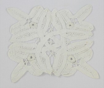
Textile - Haeusler Collection Handmade Broderie Anglaise Doily c.1920s
The Wodonga Historical Society collection comprises manuscripts, personal artefacts used by the Haeusler family on their farm in Wodonga, and a set of glass negatives which offer a unique visual snapshot of the domestic and social lives of the Haeusler family and local Wodonga community. The Haeusler family migrated from Prussia (Germany) to South Australia in the 1840s and 1850s, before purchasing 100 acres of Crown Land made available under the Victorian Lands Act 1862 (also known as ‘Duffy’s Land Act’) in 1866 in what is now Wodonga West. The Haeusler family were one of several German families to migrate from South Australia to Wodonga in the 1860s. The textiles in the Haeusler collection belonged to Ilma Margaret Ernestine Haeusler (née Tasker), born in 1900 in Tallangatta. These textiles were handmade by Ilma between 1919 and 1928 for use in the family home during her marriage to Louis Alfred Haeusler (b.1878). Ilma died in childbirth in 1928, leaving one surviving son, John Alfred Lyell (b.1922). This doily is one of several domestic objects in the Haeusler Collection that represent family and home life in early twentieth century Wodonga. It was made using the broderie anglaise needlework technique that incorporates embroidery, cutwork and needle lace. This technique originated in sixteenth century Europe and became popular in England in the nineteenth century. In the nineteenth and early twentieth century prior to the mass production of clothing and textiles, needlework, alongside motherhood, was the defining work of women. Hand sewing and embroidery was central in the everyday lives and domestic roles of women. The item is handmade and unique, with well documented provenance. It forms part of a significant and representative historical collection which reflects the local history of Wodonga. It contributes to our understanding of domestic and family life in early twentieth century Wodonga, as well as providing interpretative capacity for themes including local history, social history, and women’s history.A handmade white broderie anglaise doily c.1920sneedlework, textiles, sewing, handiwork, women's history, domestic, craft, family -
 Wodonga & District Historical Society Inc
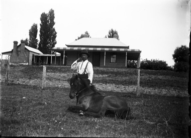
Negative - Haeusler Glass Negatives Collection - Jack Parker and the pony he taught to do tricks
The Wodonga Historical Society Haeusler Collection provides invaluable insight into life in late nineteenth and early twentieth century north east Victoria. The collection comprises manuscripts, personal artefacts used by the Haeusler family on their farm in Wodonga, and a set of glass negatives which offer a unique visual snapshot of the domestic and social lives of the Haeusler family and local Wodonga community. The Haeusler family migrated from Prussia (Germany) to South Australia in the 1840s and 1850s, before purchasing 100 acres of Crown Land made available under the Victorian Lands Act 1862 (also known as ‘Duffy’s Land Act’) in 1866 in what is now Wodonga West. The Haeusler family were one of several German families to migrate from South Australia to Wodonga in the 1860s. This digital image was produced from one of the glass negatives that form part of the collection, probably taken by Louis Haeusler (b.1887) with the photographic equipment in the Wodonga Historical Society Haeusler Collection. Parker Family - Samuel Skelton Parker, Jack Parker’s father, migrated to Australia from Ballymena, Country Antrim, Ireland in 1884. He married Bridget Cusack from County Clare in 1883. They had children William, James, Jack, Samuel and Rachel. After working on a station in northern NSW, they moved to Barnawartha and set up a butchery and later a bakery. In 1890 the family moved to Wodonga, buying a property in West Wodonga, which he called “Park Hall” after his home in Ireland. The property is now the location of the Wodonga Golf Club in Parkers Road, West Wodonga.This item is unique and has well documented provenance and a known owner. It forms part of a significant and representative historical collection which reflects the local history of Wodonga. It contributes to our understanding of domestic and family life in early twentieth century Wodonga, as well as providing interpretative capacity for themes including local history and social history.Digital image created from the Haeusler Glass negative collection. Jack Parker and his pony in the centre front of the image. Jack taught this pony to perform several tricks. The Parker family home and some outbuildings are visible in the background. This is a substantial brick house with corrugated iron roof.wodonga pioneers, haeusler family, glass negatives, dry plate photography, parker family wodonga -
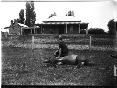 Wodonga & District Historical Society Inc
Negative - Haeusler Glass Negatives Collection - Jack Parker with the pony he taught to do tricks
The Wodonga Historical Society Haeusler Collection provides invaluable insight into life in late nineteenth and early twentieth century north east Victoria. The collection comprises manuscripts, personal artefacts used by the Haeusler family on their farm in Wodonga, and a set of glass negatives which offer a unique visual snapshot of the domestic and social lives of the Haeusler family and local Wodonga community. The Haeusler family migrated from Prussia (Germany) to South Australia in the 1840s and 1850s, before purchasing 100 acres of Crown Land made available under the Victorian Lands Act 1862 (also known as ‘Duffy’s Land Act’) in 1866 in what is now Wodonga West. The Haeusler family were one of several German families to migrate from South Australia to Wodonga in the 1860s. This digital image was produced from one of the glass negatives that form part of the collection, probably taken by Louis Haeusler (b.1887) with the photographic equipment in the Wodonga Historical Society Haeusler Collection. Parker Family - Samuel Skelton Parker, Jack Parker’s father, migrated to Australia from Ballymena, Country Antrim, Ireland in 1884. He married Bridget Cusack from County Clare in 1883. They had children William, James, Jack, Samuel and Rachel. After working on a station in northern NSW, they moved to Barnawartha and set up a butchery and later a bakery. In 1890 the family moved to Wodonga, buying a property in West Wodonga, which he called “Park Hall” after his home in Ireland. The property is now the location of the Wodonga Golf Club in Parkers Road, West Wodonga.This item is unique and has well documented provenance and a known owner. It forms part of a significant and representative historical collection which reflects the local history of Wodonga. It contributes to our understanding of domestic and family life in early twentieth century Wodonga, as well as providing interpretative capacity for themes including local history and social history.Digital image created from the Haeusler Glass negative collection. Jack Parker sitting on his pony which is lying down on the ground. Jack taught this pony to perform several tricks. The Parker family home and some outbuildings are visible in the background. This is a substantial brick house with corrugated iron roof.wodonga pioneers, haeusler family, glass negatives, dry plate photography, parker family wodonga, horsemanship