Showing 1406 items
matching bushfire
-
 Marysville & District Historical Society
Photograph (Item) - Black and white photograph, Roy Liebig, 04-1949
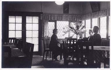
A black and white photograph taken in a dining area in the Crossways Cabaret in April, 1949. The Crossways was built in the early 1920s and is the oldest building in Marysville. The Crossways historic inn survived the 2009 Black Saturday bushfires thanks to the efforts of its c-owner Greg Cherry and, in the days after the fires, provided a much-needed refuge to the Marysville community and firefighters. A black and white photograph taken in a dining area in the Crossways Cabaret in April, 1949.My wife Katie,/ does a little talking/ at the Crossways Cabaret./ Marysville Visit,/ April 1949.marysville, victoria, australia, photograph, the crossways cabaret, the crossways, crossways, crossways country inn, crossways historic inn, 2009 black saturday bushfires, accommodation, roy liebig -
 Eltham District Historical Society Inc
Newsletter, Newsletter, No. 217 July 2014
Contents: • Fabbro Fields • Next Meeting • Heritage Excursion – Walter Withers drive yourself excursion • July Meeting – Montmorency; The farm on the Plenty • July Excursion • Benjamin Wallis; a prominent early Eltham resident by Russell Yeoman • Fire • Local Bushfire History • Facebook by Jim Connor • Member Subscriptions • And Also • Contacts for the Eltham District Historical Society The Shire of Eltham Historical Society was formed in October 1967. The first newsletter of the Society was issued May 1978 and has been published continuously ever since on a bi-monthly basis. With the cessation of the Shire of Eltham in late 1994, the Society's name was revised to Eltham District Historical Society and this name first appeared with issue No. 103, July 1995. The collection of the Society's newsletters provides a valuable resource on the history of the Society's activities, office bearers and committee members, guest speakers and subjects of historical interest pertinent to the former Shire of Eltham and the Eltham District.A4 photocopied newsletter distributed to membersnewsletter, eltham district historical society, shire of eltham historical society -
 Marysville & District Historical Society
Photograph (Item) - Colour photograph, Unknown
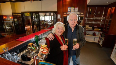
A digital copy of a colour photograph taken of the proprietors inside the interior of The Crossways in Marysville. The Crossways was built in the early 1920s and is the oldest building in Marysville. The Crossways historic inn survived the 2009 Black Saturday bushfires thanks to the efforts of its co-owner Greg Cherry and, in the days after the fires, provided a much-needed refuge to the Marysville community and firefighters.A digital copy of a colour photograph taken of the proprietors inside the interior of The Crossways in Marysville.marysville, victoria, australia, the crossways cabaret, the crossways, crossways, crossways country inn, crossways historic inn, 2009 black saturday bushfires, accommodation, crossways historic country inn, photograph -
 Marysville & District Historical Society
Photograph (Item), Roy Liebig, Unknown
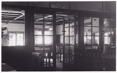
A black and white photograph of the view looking from the supper room into the dance room at the Crossways Cabaret in Marysville. The Crossways was built in the early 1920s and is the oldest building in Marysville. The Crossways historic inn survived the 2009 Black Saturday bushfires thanks to the efforts of its c-owner Greg Cherry and, in the days after the fires, provided a much-needed refuge to the Marysville community and firefighters. A black and white photograph of the view looking from the supper room into the dance room at the Crossways Cabaret in Marysville.Looking from the supper room/ into the dance room at the/ Crossways Cabaret./ Marysville Visit.marysville, victoria, australia, photograph, the crossways cabaret, the crossways, crossways, crossways country inn, crossways historic inn, 2009 black saturday bushfires, accommodation, roy liebig -
 Eltham District Historical Society Inc
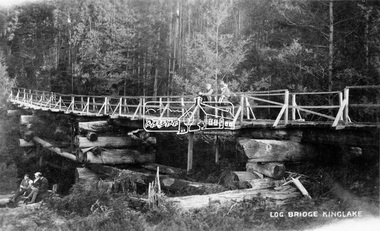
Negative - Photograph, Log bridge over Pheasant Creek, Kinglake, c.1920
Postcard view of pedestrian log bridge in Kinglake National Park. The log bridge over Johnston's Creek is said to have been built to allow the timber tramline to cross the creek. The bridge was destroyed in the 1926 bushfires. Other sources describe this bridge being located at Pheasant Creek (between Kinglake West and Kinglake Central) and that it was built by Mr Munro, the owner of the sawmill.This photo forms part of a collection of photographs gathered by the Shire of Eltham for their centenary project book,"Pioneers and Painters: 100 years of the Shire of Eltham" by Alan Marshall (1971). The collection of over 500 images is held in partnership between Eltham District Historical Society and Yarra Plenty Regional Library (Eltham Library) and is now formally known as 'The Shire of Eltham Pioneers Photograph Collection.' It is significant in being the first community sourced collection representing the places and people of the Shire's first one hundred years.Digital image 4 x 5 inch B&W Neg 1 printshire of eltham pioneers photograph collection, kinglake, log bridge, bridge, mr. munro, timber tramway, pheasant creek -
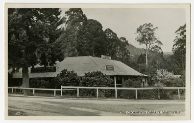
 Marysville & District Historical Society
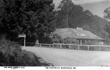
Postcard (Item) - Black and white postcard, Rose Stereograph Company, THE CROSSWAYS, MARYSVILLE, VIC, 1923-1963
A digital copy of a black and white postcard of The Crossways in Marysville produced by the Rose Stereograph Company as a souvenir of Marysville. The Crossways was built in the early 1920s and is the oldest building in Marysville. The Crossways historic inn survived the 2009 Black Saturday bushfires thanks to the efforts of its co-owner Greg Cherry and, in the days after the fires, provided a much-needed refuge to the Marysville community and firefighters.A digital copy of a black and white postcard of The Crossways in Marysville produced by the Rose Stereograph Company as a souvenir of Marysville.marysville, victoria, australia, postcard, rose stereograph company, rose series, p. 2544, souvenir, the crossways, crossways country inn, crossways historic country inn, accommodation -
 Marysville & District Historical Society
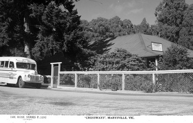
Postcard (Item) - Black and white postcard, Rose Stereograph Company, "CROSSWAYS", MARYSVILLE, VIC, 1923-1963
A digital copy of a black and white postcard of The Crossways in Marysville produced by the Rose Stereograph Company as a souvenir of Marysville. The Crossways was built in the early 1920s and is the oldest building in Marysville. The Crossways historic inn survived the 2009 Black Saturday bushfires thanks to the efforts of its co-owner Greg Cherry and, in the days after the fires, provided a much-needed refuge to the Marysville community and firefighters.A digital copy of a black and white postcard of The Crossways in Marysville produced by the Rose Stereograph Company as a souvenir of Marysville.marysville, victoria, australia, postcard, rose stereograph company, rose series, souvenir, the crossways, crossways country inn, crossways historic country inn, accommodation, p. 3292 -
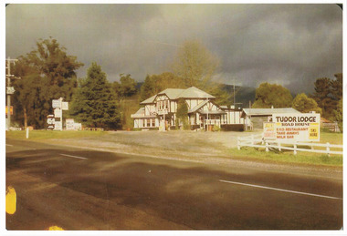
 Marysville & District Historical Society
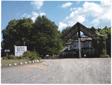
Photograph (item) - Colour photograph, Unknown
A colour photograph of Tudor Lodge Roadhouse in Narbethong in Victoria. After being known as Misty Hills Guest House it became Tudor Lodge Cafe then Tudor Lodge Roadhouse. The building was destroyed in the 2009 Black Saturday bushfires. The building was subsequently rebuilt albeit as a smaller building and was known as Wombat Cottage. That business was then sold and the property is now known as Oaktree Guest House.A colour photograph of Tudor Lodge Roadhouse in Narbethong in Victoria.narbethong, victoria, tudor lodge roadhouse, tudor house cafe, misty hills guest house, 2009 black saturday bushfires, oaktree guest house, accommodation, photograph, wombat cottage -
 Marysville & District Historical Society
Photograph (item) - Colour photograph, Unknown
A colour photograph of Tudor Lodge Roadhouse in Narbethong in Victoria. After being known as Misty Hills Guest House it became Tudor Lodge Cafe then Tudor Lodge Roadhouse. The building was destroyed in the 2009 Black Saturday bushfires. The building was subsequently rebuilt albeit as a smaller building and was known as Wombat Cottage. That business was then sold and the property is now known as Oaktree Guest House.A colour photograph of Tudor Lodge Roadhouse in Narbethong in Victoria.narbethong, victoria, tudor lodge roadhouse, tudor house cafe, misty hills guest house, 2009 black saturday bushfires, oaktree guest house, accommodation, photograph, wombat cottage -
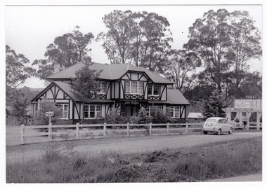 Marysville & District Historical Society
Photograph (Item) - Black and white photograph, Unknown
A black and white photograph of Tudor Lodge Cafe in Narbethong in Victoria. After being known as Misty Hills Guest House it became Tudor Lodge Cafe then Tudor Lodge Roadhouse. The building was destroyed in the 2009 Black Saturday bushfires. The building was subsequently rebuilt albeit as a smaller building and was known as Wombat Cottage. That business was then sold and the property is now known as Oaktree Guest House.A black and white photograph of Tudor Lodge Cafe in Narbethong in Victoria. narbethong, victoria, tudor lodge cafe, misty hills guest house, tudor lodge roadhouse, oaktree guest house, photograph, accommodation, wombat cottage, 2009 black saturday bushfires -
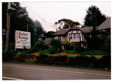 Marysville & District Historical Society
Photograph (item) - Colour photograph, Unknown
A colour photograph of Tudor Lodge Roadhouse in Narbethong in Victoria. After being known as Misty Hills Guest House it became Tudor Lodge Cafe then Tudor Lodge Roadhouse. The building was destroyed in the 2009 Black Saturday bushfires. The building was subsequently rebuilt albeit as a smaller building and was known as Wombat Cottage. That business was then sold and the property is now known as Oaktree Guest House.A colour photograph of Tudor Lodge Roadhouse in Narbethong in Victoria.narbethong, victoria, tudor lodge roadhouse, photograph, accommodation, 2009 black saturday bushfires, oaktree guest house, misty hills guest house, tudor lodge cafe, wombat cottage -
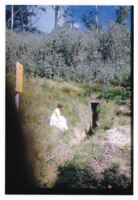 Marysville & District Historical Society
Photograph (item) - Colour photograph, 04-1960
A colour photograph of the entrance to a fire dugout on Mount Margaret near Marysville in Victoria.A colour photograph of the entrance to a fire dugout on Mount Margaret near Marysville in Victoria. The fire refuge dugout, which developed in the era of bush sawmilling in the early twentieth century, was a distinctive cultural response to the history of fire in the tall Victorian forests. Few dugouts were built in other forest regions of Australia, but those that did exist in these Victorian ranges saved dozens of lives in the fires of Black Friday 1939.27 'Fire Dug out' Mt Margaret April 1960mount margaret, marysville, victoria, fire dugout, sawmilling industry, black friday 1939, bushfire -
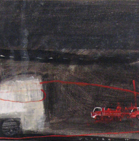 Federation University Art Collection
Painting - Artwork, Black Day, 2012
'Black Day' was part of a series of paintings drawn from a larger body of work produced over a four-year period exploring the 'harsher side' of the Australian landscape and the aftermath of extreme weatehr events and climatic occurences of fire, flood, drough and wind. Although loosely based on real places and events, the works are essentially fictional with ideas gleaned from popular media - telveision, Internet, magazines and newspapers. While my return to abstraction and landcape painting from figuration has been relatively recent, the natural environment has always been informed by my artistic practice regardless of subject matter, and has had always informed my artistic practice regardless of subject matter, and has had a long-standing influence on the aesthetics, the compositional structre and imagery in my work. The flattening of the picture plane and the prominent horizontal and vertical marks in my composition are informed by a response to both natural and man-made interventions in the land - the muted and restricted colour palette echoing my response to extrems in environmental changes, particulalry of cental and western ditrict Victoria. Created in the studio environment, I consisder this boxy of work as being imaginative 'conglomerates' which reflect varying perspectives and textural interpretrations of the land - defining and expresssing my response to particular and significant climatic, environmental events and my personal experiances. September 2012Tarli GLOVER Tarli Glover undertook a Bachelor of Arts at Ballarat College of Advanced Education [now Federation University] between 1980 and 1983, majoring in Fine Art Painting. Based in Central Victoria, she has been practicing professionally for over three decades and has exhibited widely throughout Australia. While Tarli's work covers a wide range of creative disciplines’ she concentrate’s primarily on painting, drawing and multi-media works with a focus on both landscape and figurative genres. Her work leans toward semi abstract symbolism and representation. This item is part of the Federation University Art Collection and was purchased for the collection by Vice Chancellor David Battersby. The Art Collection features over 2000 works and was listed as a 'Ballarat Treasure' in 2007.Acrylic on canvas paintingart, artwork, glover, tarli glover, bushfire, alumni, available -
 Southern Sherbrooke Historical Society Inc.
Information folder - Fires 2003, 2003
Folder containing information pertaining to the 2003 Victorian, NSW & ACT bushfires. Contents: -3 photos of Omeo after the fires, by Dulcie Strahan -DSE/DPI Fire Update report dated 21st February -2 photos of fires in North-east Victoria by Andrew Aubert -3 Fire Overview maps, dated 24 January, 27 January (2 copies) and 16 February -leaflet, "Upper Murray Fires", community update, dated 12 January -copy of fire overview map, dated 16 February, with annotations -weather page, Border Mail, 8 Januarybushfires -
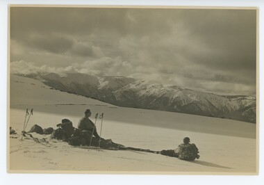 Falls Creek Historical Society
Photograph - Bogong Trip 1951- Mt. Bogong from above Roper's Hut
MEYER COLLECTION - FALLS CREEK PHOTOS In 1947 a determined group of like-minded State Electricity Commission (SEC) staff including Ray Meyer, the chief surveyor of the Kiewa Hydro-Electric Scheme, had a common interest that revolved around the skiing potential of the snow-covered high plains which included what is now the resort of Falls Creek. The six SEC employees, Toni St Elmo, Ray Meyer, Jack Minogue, Lloyd Dunn, Adrian Ruffenacht and Dave Gibson (together with their families) banded together to secretly build a 'hut' that was the first ski lodge at Falls Creek. Using a road built in 1930s to gain access to Falls Creek, their hut project was carried out in secret as efforts by other skiers were blocked by H.H.C. Williams – the engineer in charge of the Hydro Scheme. In 1946 Ray Meyer made a trip to the Lands Office in Melbourne. He came away with a 99-year lease on three acres that was ideally suited for a hut designed by Lloyd Dunn. Adrian Ruffenacht (Design Engineer for the KHS) had suggested where the group should build because of easy access to a spring for water. Much of the building material required was scavenged from derelict huts on the high plains. Due to the need for secrecy, the determined group worked on the hut in the evenings and weekends to avoid detection. During the building period the group had met at Echidna Rock (now known as Eagle Rock) where Skippy St Elmo announced, "This is my favourite ‘Skyline’.” And so the first lodge in the area at Falls Creek Ski Resort came into existence. With the development of the International Poma in the 1970s, the Skyline Lodge, which was sited between the ski-lift’s pole one and pole two, was demolished. However, the legacy of Ray Meyer, Toni St Elmo, Jack Minogue, Lloyd Dunn, Adrian Ruffenacht and Dave Gibson and Skyline lives on in the vibrant atmosphere of Falls Creek Resort. The MEYER COLLECTION documents developments on the Kiewa Hydro Scheme and their life at Falls Creek from the mid 1930s to 1960s.This image is significant because it depicts aspects of the life of a pioneering family of Falls Creek and the founders of "Skyline", the first lodge at Falls Creek.Black and White Image of Mt. Bogong from above Roper's Hut with Wal Johnson and Ray Meyer seated on the ground. ROPER'S HUT Frederick Roper and his family grazed the Bogong High Plains from the 1890s until 1908. Frederick "Jack" built three huts. The hut known as Roper’s Hut was built on Jack's new grazing lease after his former run had been acquired by the SEC in the late 1930s. It had become a well-used refuge hut prior to its destruction in the 2003 bushfires. It was rebuilt by Victorian High Country Huts Association in 2008.falls creek, bogong high plains, wal johnson, ray meyer, ropers hut -
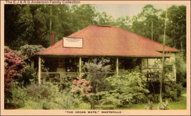 Marysville & District Historical Society
Postcard (Item) - Colour tinted postcard, "THE CROSS WAYS," MARYSVILLE, 1940s
A digital copy of a colour tinted postcard of The Crossways Cabaret in Marysville from the E.J. and R.G. Anderson Family Collection. The Crossways was built in the early 1920s and is the oldest building in Marysville. The Crossways historic inn survived the 2009 Black Saturday bushfires thanks to the efforts of its co-owner Greg Cherry and, in the days after the fires, provided a much-needed refuge to the Marysville community and firefighters.A digital copy of a colour tinted postcard of The Crossways Cabaret in Marysville from the E.J. and R.G. Anderson Family Collection.marysville, victoria, australia, the crossways cabaret, the crossways, crossways, crossways country inn, crossways historic inn, 2009 black saturday bushfires, accommodation, crossways historic country inn, postcard, souvenir, ej & rg anderson family collection -
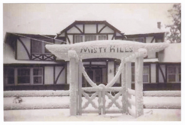 Marysville & District Historical Society
Photograph (Item) - Black and white photograph, Unknown
A black and white photograph of Misty Hills Guest House in Narbethong in Victoria. After being known as Misty Hills Guest House it became Tudor Lodge Cafe then Tudor Lodge Roadhouse. The building was destroyed in the 2009 Black Saturday bushfires. The building was subsequently rebuilt albeit as a smaller building and was known as Wombat Cottage. That business was then sold and the property is now known as Oaktree Guest House.A black and white photograph of Misty Hills Guest House in Narbethong in Victoria.narbethong, victoria, misty hills guest house, photograph, tudor lodge cafe, tudor lodge roadhouse, wombat cottage, oaktree guest house, 2009 black saturday bushfires -
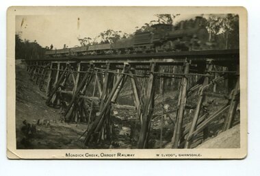 Orbost & District Historical Society
black and white photograph, Vogt. W.S, first half 20th century
This 97km Bairnsdale to Orbost extension through rugged terrain was reputed to have been the most difficult rail project undertaken in Victoria. This wooden bridge was one of the unique railway bridges of the East Gippsland Railway line. Mundic Creek Bridge is of unique design because the line crosses at a very sharp angle. This bridge like many others on the line have "disappeared". This one, probably because of a bushfire.The Bairnsdale to Orbost rail line contains the most varied range Of timber & timber composite bridges on any Victorian line. This photograph is a record of that. A black / white photograph of a train on a wooden railway bridge at Mundic Creek.on front - Mundic Creek, Orbost Railway W.S.Vogt, Bairnsdalemundic-creek-bridge east-gippsland-railway -
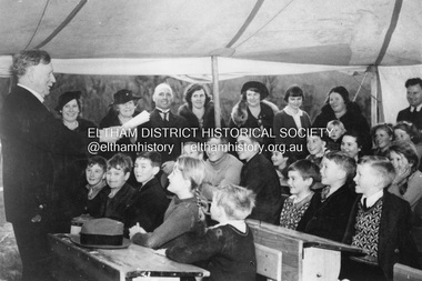 Eltham District Historical Society Inc
Photograph, The Age, Mr. William H. Everard, M.L.A. addressing children at South Warrandyte Primary School, 30 Jun 1939
South Warrandyte State School was destroyed in the Black Friday bushfire of 13 Jan. 1939. Whilst a new school building was being constructed, classes were conducted in a tent as seen in this image from 'The Age" of Mr William Everard, M.L.A.delivering his 22nd annual Arbor Day address to children of the school on 30 June 1939. Mr Everard returned on October 7 to officially open the new school.south warrandyte state school, william h. everard, arbor day, black friday -
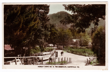 Marysville & District Historical Society
Postcard (Item) - Colour tinted postcard, Murray Views, MURRAY VIEWS NO. 18. THE CROSSWAYS, MARYSVILLE, VIC, Unknown
A black and white postcard of the Crossways in Marysville in Victoria published by Murray Views. The Crossways was built in the early 1920s and is the oldest building in Marysville. The Crossways historic inn survived the 2009 Black Saturday bushfires thanks to the efforts of its c-owner Greg Cherry and, in the days after the fires, provided a much-needed refuge to the Marysville community and firefighters. This postcard was produced by Murray Views in Gympie in Queensland as a souvenir of Marysville.A black and white postcard of the Crossways in Marysville in Victoria published by Murray Views.POST CARD STAMP REAL PHOTOGRAPH PRODUCED IN/ AUSTRALIA BY MURRAY VIEWS, GYMPIE, Q.marysville, victoria, australia, postcard, souvenir, crossways cabaret, crossways historic inn, crossways country inn, murray views no. 18, accommodation, 2009 black saturday bushfires -
 Marysville & District Historical Society
Photograph (Item) - Black and white photograph, 1948
A black and white photograph of an unknown lady standing outside The Crossways in Marysville. The Crossways was built in the early 1920s and is the oldest building in Marysville. The Crossways historic inn survived the 2009 Black Saturday bushfires thanks to the efforts of its c-owner Greg Cherry and, in the days after the fires, provided a much-needed refuge to the Marysville community and firefighters. The photograph has been incorrectly labeled as "THE CROSSINGS" CABARET.A black and white photograph of an unknown lady standing outside The Crossways in Marysville."THE CROSSINGS" CABARET/ MARYSVILLE 1948marysville, victoria, australia, photograph, the crossways, crossways cabaret, crossways historic inn, crossways country inn, accommodation, 2009 black saturday bushfires -
 Bendigo Historical Society Inc.
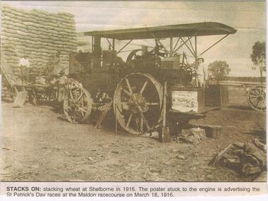
Newspaper - JENNY FOLEY COLLECTION: STACKS ON
The Maldon-Laanacoorie railway line was never completed so Shelbourne became to termination point of this line. The station and railway yards opened in 1891 ad were last used in 1969 after bushfires had destroyed bridges on the line. The advertised St Patrick's Day race meeting was held on Saturday 18th March and a special train for patrons was run form Castlemaine, leaving at 1.15pm and returning at 7pm.Bendigo Advertiser '' the way we were'' from 2002. Stacks on: stacking wheat at Shelborne in 1916. The poster stuck to the engine is advertising the St Patrick's Day races at the Maldon racecourse on March 18, 1916. The clip is in a folder.newspaper, bendigo advertiser, the way we were -
 Wooragee Landcare Group
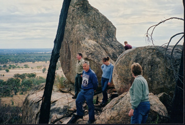
Photograph, circa April 2003
This photograph was taken in the Mount Pilot Chiltern National Park. It was taken during a search for the tiger quoll conducted by a team of volunteers from the Wooragee Landcare Group. The tiger quoll is also known as the spotted-tail quoll and is found in the national park. The 2003 bushfires caused worry for the safety of the tiger quoll, hence the need for a search for it. Mount Pilot Chiltern National Park is located near Chiltern in Victoria. It's most notable landmarks include Mt Pilot and Woolshed Falls. It also has many mines from the Gold Rush in the late 1800s. It is home to much flora and fauna, including the tiger quoll. The park is also home to the box-ironbark forest that once was present in most of north-eastern Victoria. The park is a large tourist destination as in there are many bushwalks and other attractions for visitors. In 2003, bushfires raged through Mount Pilot National Park and destroyed much of the environment. Some of this damage can be seen in the burnt trees in the picture. This photograph represents the work that goes into protecting a important species like the tiger quoll and there has been much work done to preserve it. This photograph was taken when the Wooragee Landcare group went to ensure the survival of this species, highlighting how the tiger quoll is being protected. This photograph also demonstrates the significance of Mount Pilot Chiltern National Park. The park has many special flora and fauna that can only be found in this area. For example, the box-ironbark forest and the tiger quoll. The forest used to stretch over much of north-eastern Victoria and is therefore reminiscent of what that area of Victoria was once like. This park is historical for this reason but it is also historical through it being once goldfields from the Gold Rush in the 1800s.Landscape coloured photograph printed on gloss paperReverse: WAN NA 0ANA2N0 NNN- 1 1636 / [PRINTED] (No.8) / 922mount pilot, mount pilot chiltern national park, chiltern, victoria, landmark, woolshed falls, gold rush, tiger quoll, flora, fauna, spotted tail quoll, marsupial, andy murray, andy murray quolls, carnivorous marsupial, forests, rainforests, coastal heathlands, woodlands, photograph, species, wooragee, wooragee landcare group, wooragee landcare, bushfires, identification, search, dna, droppings, box ironbark forest, ironbark, box iron bark -
 Marysville & District Historical Society
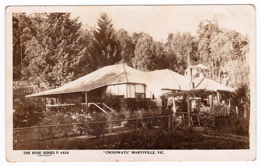
Postcard (Item) - Black and white postcard, Rose Stereograph Company, "CROSSWAYS," MARYSVILLE, VIC, 1923-1967
A black and white postcard of the Crossways historic inn in Marysville in Victoria. The Rose Series P. 4826. The Crossways was built in the early 1920s and is the oldest building in Marysville. The Crossways historic inn survived the 2009 Black Saturday bushfires thanks to the efforts of its c-owner Greg Cherry and, in the days after the fires, provided a much-needed refuge to the Marysville community and firefighters. This postcard was produced by the Rose Stereograph Company as a souvenir of Marysville.A black and white postcard of the Crossways historic inn in Marysville in Victoria.THE ROSE SERIES P. 4826/ COPYRIGHT "CROSSWAYS," MARYSVILLE, VIC. POST CARD The "Rose" Series/ De Luxe A Real Photograph/ Produced in Australia Published by the Rose Stereograph Co./ Armadale, Victoria. 30.5-34 Dear Shirley/ How are you all getting along/ I got your letter a long time ago. You/ got a lot of presents you ought to have/ another one soon. This is the place where/ I work you cannot take a picture of the/ front of the place because it's big trees./ This is the back photo the kitchen is on the/ right. There is no news. Hoping Mum & Dad & Arch/ are all well Yours Lovingly Fred xx xx/ I'll give him a knock in the eye for Archie xxxxmarysville, victoria, australia, crossways historic inn, accommodation, 2009 black saturday bushfires, rose stereograph company, rose series, p. 4826, postcard, souvenir -
 Marysville & District Historical Society
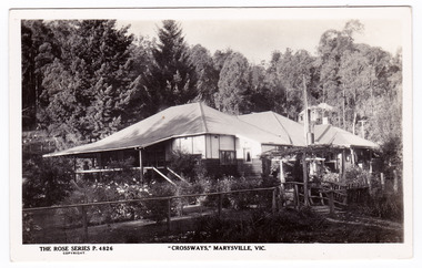
Postcard (Item) - Black and white postcard, Rose Stereograph Company, "CROSSWAYS," MARYSVILLE, VIC, 1923-1967
A black and white postcard of the Crossways historic inn in Marysville in Victoria. The Rose Series P. 4826. The Crossways was built in the early 1920s and is the oldest building in Marysville. The Crossways historic inn survived the 2009 Black Saturday bushfires thanks to the efforts of its c-owner Greg Cherry and, in the days after the fires, provided a much-needed refuge to the Marysville community and firefighters. This postcard was produced by the Rose Stereograph Company as a souvenir of Marysville.A black and white postcard of the Crossways historic inn in Marysville in Victoria.THE ROSE SERIES P. 4826/ COPYRIGHT "CROSSWAYS," MARYSVILLE, VIC. POST CARD The "Rose" Series/ De Luxe A Real Photograph/ Produced in Australia Published by the Rose Stereograph Co./ Armadale, Victoria.marysville, victoria, australia, crossways historic inn, accommodation, 2009 black saturday bushfires, rose stereograph company, rose series, p. 4826, postcard, souvenir -
 Marysville & District Historical Society
Postcard (Item) - Black and white postcard, Valentine Publishing Co. Pty. Ltd, THE CROSSWAYS CABARET, MARYSVILLE, 1923-1963
A black and white postcard of the Crossways Cabaret in Marysville in Victoria. A Valentine's postcard V36. The Crossways was built in the early 1920s and is the oldest building in Marysville. The Crossways historic inn survived the 2009 Black Saturday bushfires thanks to the efforts of its c-owner Greg Cherry and, in the days after the fires, provided a much-needed refuge to the Marysville community and firefighters. This postcard was produced by Valentine Publishing Co Pty. Ltd as a souvenir of Marysville.A black and white postcard of the Crossways Cabaret in Marysville in Victoria. A Valentine's postcard V36.VALENTINE'S/ POST CARD/ A GENUINE PHOTOGRAPHmarysville, victoria, australia, crossways cabaret, crossways historic inn, accommodation, postcard, souvenir, valentine publishing co pty ltd, v. 36, 2009 black saturday bushfires -
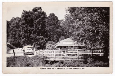 Marysville & District Historical Society
Postcard (Item) - Black and white postcard, Murray Views, MURRAY VIEWS NO. 27. CROSSWAYS CABARET, MARYSVILLE, VIC, Unknown
A black and white postcard of the Crossways Cabaret in Marysville in Victoria published by Murray Views. The Crossways was built in the early 1920s and is the oldest building in Marysville. The Crossways historic inn survived the 2009 Black Saturday bushfires thanks to the efforts of its c-owner Greg Cherry and, in the days after the fires, provided a much-needed refuge to the Marysville community and firefighters. This postcard was produced by Murray Views in Gympie in Queensland as a souvenir of Marysville.A black and white postcard of the Crossways Cabaret in Marysville in Victoria published by Murray Views.marysville, victoria, australia, postcard, souvenir, crossways cabaret, crossways historic inn, crossways country inn, murray views no. 27, accommodation, 2009 black saturday bushfires -
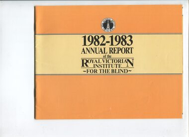 Vision Australia
Administrative record - Text, Royal Victorian Institute for the Blind annual report 1982-1983, 1982-1983
Activities in annual report include: retirement of Ralph Lightfoot, appointment of Frances Warren, opening of Wangaratta regional office, family group home in second year providing home environment for three children, establishment of self contained flat within residential services at Burwood, bushfires threatened but did not destroy Wahpeton at Romsey and ski lodge at Mt Baw Baw, and support from hotels through 80 Lucky Envelope machines.1 volume of printed material with imagesannual report, royal victorian institute for the blind -
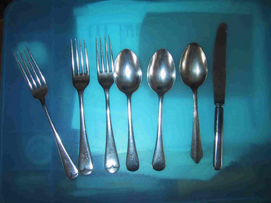 Parks Victoria - Mount Buffalo Chalet
Cutlery
These pieces of cutlery were found by a Parks Victoria ranger in a hollow log after the 2003 bushfires. It is possible these items were hidden for Chalet guests for picnics when they went out horseriding . There is reference to this practice in the "Mt Buffalo Story" 'Holidaymakers planning all day treks to distant features on the Plateau - Mount Macloed, the Great Wall of China of the Sarcophagus - collecteda packed lunch and anorange." (Pg 88. the Mount Buffalo Story)Listed in Draft Inventory of Significant Collection items. Appendix A.3.Tableware. (Pg 166 Historica).Three stainless steel forks with Victorian Railways insignia. Three stainless steel spoons, two with Victorian Railways insiginia. One stainless steel knife with Victorian Railways insiginia. (knife is burnt)On the two forks,"ALLBRITE STAINLESS STEEL" & "VR" On the two spoons,"ALLBRITE STAINLESS STEEL / VR" On burnt knife,"ALLBRITE FIRTH C....LY STAINLESS, VR" -
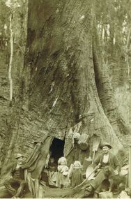 Bendigo Historical Society Inc.
Photograph - FAMILY LIVING IN LARGE TREE TRUNK
Sepia image (copy) picture shows family gathered at base of large tree trunk with door opening. Two small children in doorway, woman holding younger child inside tree, two men either side of image. Both men are wearing suit coats, vests and wearing hats. Straw broom and pots fixed to tree trunk. Man on RH side has an axe to his right. PLEASE NOTE: Letter with photo inquiring about the people in photo, states that the image is that of Peter Tyson, younger brother of James, his wife Margaret Sheil, and their twin daughters, Alice and Harriet. Diary is of accounts with limited text of a written diary on RH wide of sheets. Bookkeeper was Robert Primrose, whose name appears frequently in the book. Further research by Murray Poustie discovered that the photograph may actually be of Nicholas Penny, his wife Eva and their children Charlie, May, George and Nicholas. Also in the photograph on the left is their neighbour, Mr. John Green. The Photograph was taken by Max Lowenhardt when the Penny family was living in the tree at Fumina in 1906-07 following devastating bushfires. Fumina is in timber country at the foot of the Baw Baw Mountains and the area was frequently affected by major bushfires. The photograph was featured on the cover of the Gippsland Heritage Journal No.19, 1996 and is also extensively noted as ''The Penny family's tree home at Fumina'' in other publications including Vision & Realisation.person, receipts