Showing 2278 items
matching parish.
-
 Bendigo Historical Society Inc.
Map - JACK FLYNN COLLECTION: TOWNSHIP OF STANHOPE, December 1950
Map: Township of Stanhope, Parish of Girgarre, County of Rodney. Parish plan.By Authority J. J. Gourley, Government Printer, Melbourne. Drawn and Reproduced at the Dept, of Lands and Survey, Melbourne, Victoria.map, rodney, township, stanhope -
 Bendigo Historical Society Inc.
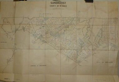
Map - JACK FLYNN COLLECTION: SANDHURST SHEET 6, January 1947
Map: Parish of Sandhurst Sheet 6. County of Bendigo. Parish plan.By Authority J. J. Gourley, Government Printer, Melbourne. Drawn and Reproduced at the Dept, of Lands and Survey, Melbourne, Victoria.map, bendigo, parish plan, sandhurst sheet 6 -
 Bendigo Historical Society Inc.
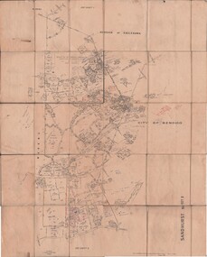
Map - JACK FLYNN COLLECTION: SANDHURST SHEET 2, January 1947
Map: Parish of Sandhurst Sheet 2, County of Bendigo. Parish plan.By Authority J. J. Gourley, Government Printer, Melbourne. Drawn and Reproduced at the Dept, of Lands and Survey, Melbourne, Victoria.map, bendigo, parish plan, sandhurst sheet 2 -
 Bendigo Historical Society Inc.
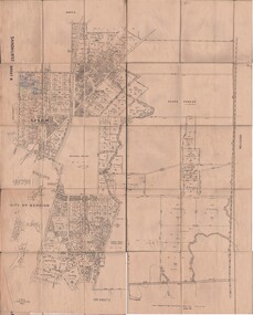
Map - JACK FLYNN COLLECTION: SANDHURST SHEET 1, January 1947
Map: Parish of Sandhurst sheet 1, County of Bendigo. Parish plan.map, bendigo, parish plan, sandhurst -
 Bendigo Historical Society Inc.
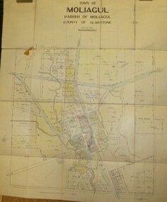
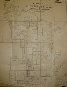
Map - JACK FLYNN COLLECTION: MOLIAGUL, 7/02/1931
Map: Township of Moliagul, Parish of Moliagul, County of Gladstone. Parish plan.map, gladstone, township, moliagul -
 Bendigo Historical Society Inc.
Map - JACK FLYNN COLLECTION: MOLIAGUL, October 1946
Map: Parish of Moliagul, Sheet 1, County of Gladstone. Parish plan.map, gladstone, parish plan, moliagul -
 Bendigo Historical Society Inc.
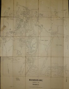
Map - JACK FLYNN COLLECTION: MANDURANG SHEET 2, March 1947
Map: Parish of Mandurang, Sheet 2, County of Bendigo. Parish plan.By Authority J.J.Gourley Government Printer Melbourne. Drawn and Produced at the Dept, of Lands and SurveyMelbourne, Victoria. March 1947.map, bendigo, parish plan, mandurang -
 Bendigo Historical Society Inc.
Map - JACK FLYNN COLLECTION: GIRGARRE, 1957
Map: Township of Girgarre, Parish of Kyabram, County of Rodney. Parish plan.By Authority: W. M. Houston, Government Printer, Melbourne. Drawn and reproduced at the Department of Lands and Survey, Melbourne.map, rodney, township, girgarre -
 Bendigo Historical Society Inc.
Map - JACK FLYNN COLLECTION: BET BET, 18/08/1931
Map: Parish of Bet Bet, Counties of Gladstone and Talbot . Parish plan.By Authority H.J. Green Govt, Printer. Photo Lithographed at the Department of Lands and Survey, Melbourne. 18.8.31map, gladstone, parish plan, bet bet, counties of gladstone and talbot. -
 Bendigo Historical Society Inc.
Map - JACK FLYNN COLLECTION: GOORNONG, August 1953
Map: Township of Goornong, Parish of Goornong, County of Bendigo. Parish plan.By Authority W.M. Houston. Government Printer. Drawn and Reproduced at the Dept., of Lands and Survey, Melbourne, Victoria. August 1953map, bendigo, township, goornong -
 Bendigo Historical Society Inc.
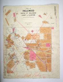
Map - TOWN OF INGLEWOOD, March 1946
Map: Town of Inglewood, Parish of Inglewood, County of Gladstone. Parish planmap, gladstone, township, inglewood -
 Bendigo Historical Society Inc.
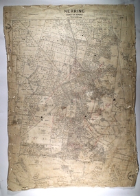
Map - NERRING, 25/08/1903 ?
Map: Parish of Nerring, County of Bendigo. Parish plan Canvas backedmap, bendigo, rural, nerring, county of bendigo -
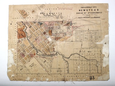 Bendigo Historical Society Inc.
Map - NEWSTEAD, 28/07/1874
Map: Newstead Town and Suburban Lots, Parish of Strangways. Parish planmap, township, newstead -
 Whitehorse Historical Society Inc.
Document, Certificate of Title, 1923 - 1934
Certificate of Title, William Arthur Hirst.Certificate of Title, William Arthur Hirst. Lot 20 Subdivision 6626, part of crown allotment 127A at Mitcham, Parish of Nunawading, Count of Bourke. Vol 4671, fol 934063. Also correspondence re rates enforcement charge, 1933-34.Certificate of Title, William Arthur Hirst.land titles, shire of blackburn and mitcham, hirst, william arthur, shire of nunawading, thomas street, mitcham -
Whitehorse Historical Society Inc.
Document, Certificate of Title, 1927, 1934
Certificate of Title, State Savings Bank of Victoria.Certificate of Title, State Savings Bank of Victoria. Part of Lot 58, Parish of Nunawading, 13 Oct 1927. Vol 5325 Fol 1064898. Letter of 24 Apr 1934 to Mr R. Bell from Council rate collector asking for arrears.Certificate of Title, State Savings Bank of Victoria.land titles, rates, shire of blackburn and mitcham, bell, r, wolseley crescent, blackburn -
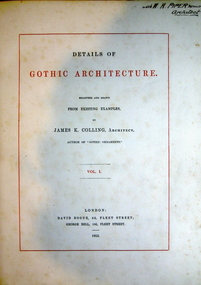 Federation University Historical Collection
Book, Details of Gothic Architecture, 1852 (exact)
“Details of Gothic Architecture is measured and drawn from existing examples by James K. Colling, author of ‘Gothic Ornaments’.“—Front cover. It contains detailed drawings of parish churches during the 19 century.A large book with blue hardcover and black cloth corners and spine. Illus. with b&w plates of architectual drawings. Vol.1. Title is printed in black and red. This book contains measured drawings of details from parish churches. It includes 8p. table of contents. Inscription on title page "W. H. Piper, architect". A plate inside front cover titled "Ballarat Technical Art School Library No. AD/14".and, architecture gothic, decoration, ornament gothic, james k colling, gothic england, norman, early english, decorated, perpendicular, burnby church, etton church, yorkshire, walsoken church, norfolk, great grimsby church, lincolnshire, bookplate, ballarat technical art school library -
 Bendigo Historical Society Inc.
Map - JACK FLYNN COLLECTION: TARNAGULLA SHEET 4, 25/11/1926
Map: Parish of Tarnagulla Sheet 4, Counties of Gladstone and Bendigo. Parish plan.Photo-Lithographed at the Department of lands and Survey, Melbourne by W. J. Butson. 25.11.26map, gladstone, parish plan, tarnagulla sheet 4 -
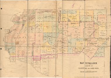 Bendigo Historical Society Inc.
Map - JACK FLYNN COLLECTION: NATTE YALLOCK, 22/06/1937
Map: Parish of Natte Yallock, Counties of Gladstone and Kara Kara. Parish plan.By Authority H.J. Green Government Printer Melbourne. Drawn and Reproduced at the Depart., of Lands and Survey, Melbourne, Victoria.map, gladstone, parish plan, natte yallock -
 Bendigo Historical Society Inc.
Map - JACK FLYNN COLLECTION: LAANACOORIE, No date visible
Map: Parish of Laanacoorie, County of Bendigo. Parish plan. Half of the sheet is missing.By Authority H.J. Green. Govt, Printer.map, bendigo, parish plan, laanacoorie -
 Bendigo Historical Society Inc.
Map - JACK FLYNN COLLECTION: VILLAGE OF BETLEY, 30/06/1874
Map: Village of Betley, on the Bet Bet Creek, Parish of Dunolly. Parish plan.Photo Lithographed at the Department of Lands and Survey Melbourne by J. Noone 30.6.74map, gladstone, village, betley, bet bet creek, dunolly -
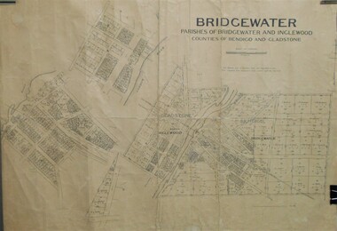 Bendigo Historical Society Inc.
Map - JACK FLYNN COLLECTION: BRIDGEWATER, 10/09/1931
Map: Bridgewater, Parishes of Bridgewater and Inglewood, Counties of Bendigo and Gladstone. Parish plan.map, bendigo, parish plan, bridgewater inglewood -
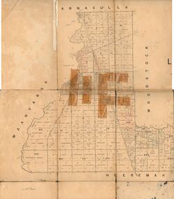
Bendigo Historical Society Inc.
Map - MUSKERRY, No date visible
Map: Parish of Muskerry. Parish plan (number 310 in map cupboard 1)map, parish plan, muskerry -
Whitehorse Historical Society Inc.
Document, Certificate of Title, 1921, 1933
Certificate of Title, Charles Norris and William Richard Norris.Certificate of Title, Charles Norris and William Richard Norris. Lot 6 Subdivision 4894, part of crown portions 89 & 90, Parish of Nunawading, County of Bourke 1922. Vol 4474, fol 894734 also correspondence re rates, enforcement of charge 1933.Certificate of Title, Charles Norris and William Richard Norris.land titles, shire of blackburn and mitcham, norris, charles, norris, william richard, blackburn road, blackburn -
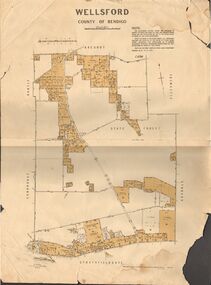 Bendigo Historical Society Inc.
Map - JACK FLYNN COLLECTION: WELLSFORD, 15/12/1941
Map: Parish of Wellsford, County of Bendigo. Parish plan. 2 copies of the same plan.map, bendigo, parish plan, wellsford -
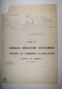 Bendigo Historical Society Inc.
Map - BENDIGO IRRIGATION SETTLEMENT, 20/10/1908
Map: Bendigo Irrigation Settlement, Parishes of Sandhurst and Wellsford, County of Bendigo, Parish planmap, bendigo, irrigation settlement, bendigo irrigation settlement -
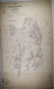 Bendigo Historical Society Inc.
Map - BOROUGH OF EAGLEHAWK SHEET 1, 9/12/1902
Map: Borough of Eaglehawk, sheet No. 1, Parish of Sandhurst, County of Bendigo. Parish planmap, bendigo, parish plan, borough of eaglehawk -
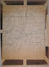
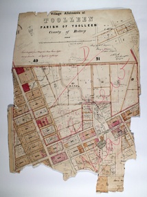 Bendigo Historical Society Inc.
Map - TOOLLEEN ALLOTMENTS, circa 1870
Map: Parish plan showing Village allotments at Toolleen, Parish of Toolleen, County of Rodneymap, rodney, toolleen, parish of toolleen, county of rodney -
 Bendigo Historical Society Inc.
Map - CAMPBELL COLLECTION: BENDIGO AND DISTRICT MAPS
Map. Eastern area of Bendigo, Parish of Huntly, Ascot, Shire of Huntly, Jackass Flat, Old White Hills, White Hills, Emu Point, North Bendigo, East Bendigo, Strathdale, Parish of Strathfieldsaye, Parish of Sandhurst, Parish of Wellsford.map, bendigo, parishes -
 Bendigo Historical Society Inc.
Map - JACK FLYNN COLLECTION: GIRGARRE, 14/10/1943
Map: Parish of Girgarre , County of Rodney. Parish plan. Same map as 10100.20 but in poorer condition.By Authority, H.E.Daw, Government printer Melbourne. Drawn and Reproduced at the Dept, of Lands and Survey, Melbourne, Victoriamap, rodney, girgarre, girgarre, county of rodney -
 Bendigo Historical Society Inc.
Map - JACK FLYNN COLLECTION: ARCHDALE, 15/01/1936
Map: Parish of Archdale, County of Gladstone. Parish plan. The Allotments have been coloured in with pencil.By Authority H.J. Green, Government Printer Melbourne. Drawn and Reproduced at the Dept, of Lands and Survey, Melbourne, Victoria. 15/01/36map, gladstone, parish plan, archdale , gladstone