Showing 199830 items matching "12-errard-street-south"
-
 Eltham District Historical Society Inc
Slide, Looking south along Bolton Street towards intersection with Rosehill Road, Lower Plenty, 18 July 1972, 1972
Reconstruction works by Eltham Shire Council, Bolton Street, Eltham, 18 July 197235 mm colour positive transparency Mount - Agfacolor Service (Blue)bolton steet, eltham, eltham shire council, infrastructure, lower plenty, road construction, rosehill road -
 Eltham District Historical Society Inc
Slide, Looking south along Bolton Street to intersection with Main Road, 18 July 1972, 1972
Reconstruction works by Eltham Shire Council, Bolton Street, Eltham, 18 July 197235 mm colour positive transparency Mount - Agfacolor Service (Blue)bolton steet, bolton street shops, eltham, eltham shire council, infrastructure, main road, road construction -
 Eltham District Historical Society Inc
Slide, Possibly looking south along Bolton Street towards intersection with Grand Boulevard, Eltham, 18 July 1972, 1972
Reconstruction works by Eltham Shire Council, Bolton Street, Eltham, 18 July 197235 mm colour positive transparency Mount - Agfacolor Service (Blue)bolton steet, eltham, eltham shire council, ht holden, infrastructure, kgf-182, road construction -
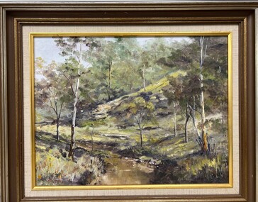 Greensborough Historical Society
Painting - Painting (Framed), Plenty River South Morang by Doug Hall, 1970s
Bush scene of the Plenty River at South Morang showing young gum trees on the river bank, painted by Greensborough artist, the late Doug Hall.This painting has strong ties to the Greensborough area, being owned by Ivy Lines who gifted it to the donor's mother-in-law.Oil painting of a bush scene, in timber frame.On back of painting "Plenty River South Morang. Doug Hall"doug hall, plenty river, south morang, painters -
 Glen Eira Historical Society
Album - Album page, Gordon Street, Circa 1972
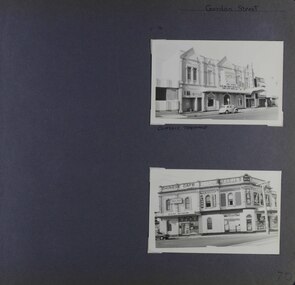
This photograph is part of the Caulfield Historical Album 1972. This album was created in approximately 1972 as part of a project by the Caulfield Historical Society to assist in identifying buildings worthy of preservation. The album is related to a Survey the Caulfield Historical Society developed in collaboration with the National Trust of Australia (Victoria) and Caulfield City Council to identify historic buildings within the City of Caulfield that warranted the protection of a National Trust Classification. Principal photographer thought to be Trevor Hart, member of Caulfield Historical Society. Most photographs were taken between 1966-1972 with a small number of photographs being older and from unknown sources. All photographs are black and white except where stated, with 386 photographs over 198 pages.From: https://vhd.heritagecouncil.vic.gov.au/places/65624 (as of 20/01/2021) National Trust listing for the Classic Cinema Property No. B7027 The Elsternwick Theatre, established in 1911 in an earlier hall, is of Regional historical and social significance. Historically, the Elsternwick Theatre is important as the longest continuously operating cinema in Victoria. However, the building itself was not purpose built as a cinema, and little remains of the early cinema interior. It is also notable as one of a handful of early cinemas in Victoria to still operate. The Elsternwick Theatre is socially significant for its association with cinema, the major form of popular entertainment in the early twentieth century. Prior to the conversion of the premises into a picture theatre in 1911, the building was an important community gathering place; as a public hall and lodge rooms. Architectural interest is restricted to the late Victorian facade, with its relatively unusual three bay arrangement, each topped by large triangular pediments that project beyond the parapet, providing an interesting silhouette.Page 70 of Photograph Album with two portrait photographs (external views) of properties on Gordon StreetHand written: Gordon Street [top right] / CLASSIC THEATRE [under top photo] / 70[bottom right] trevor hart, glen huntly road, gordon street, elsternwick, theatre, corner shops, classic cinema, elsternwick theatre, shops, cars, glenhuntly road, chinese cafes, kum san restaurant, p calandro & co real estate agents -
 Federation University Historical Collection
Document, Peter Fryar, A short history and discussion paper regarding factors influencing the introduction of "Physical Education" courses into Victorian Tertiary Education and to Ballarat Post Secondary Institutions in particular, by Peter Fryar
Retired Dean of the Faculty of Human Studies, Peter Fryar, was invited to prepare this short history for lodgement in the University of Ballarat Historical Collection (later Federation University Historical Collection).10 typed pages by Peter Fryar outlined introduction of Physical Education studies at a Tertiary Level at Ballarat peter fryar, physical education, mount helen campus -
 Old Castlemaine Schoolboys Association Inc.
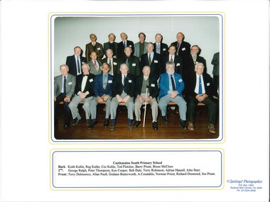
Photograph, Past Pupils Castlemaine South Primary School 2001, 13/10/2001
Photograph depicting past pupils of the Castlemaine south Primary School. Taken at Reunion in 2001 -
 Tatura Irrigation & Wartime Camps Museum
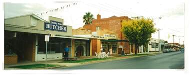
Photograph, Douglas Quality Butchers Hogan Street Tatura
Shows picture of Douglas Quality Butcher, Hogan Street, Tatura. Also Bank of New South Wales and National Bank.Colour photograph showing Douglas Quality Butcher in Hogan Street, Tatura and other businesses to the right of the butchers including the Bank of New South Wales and National Bank. Photograph stuck onto piece of white cardboard. hogan street tatura, douglas butchers tatura, bank of new south wales tatura, national bank tatura -
 Eltham District Historical Society Inc
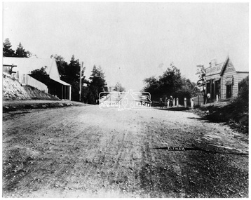
Negative - Photograph, Main Road, Eltham, looking south from Bridge Street, 1906-1907
Looking south along Main Road from the south side of the intersection of Bridge Street with Main Road. Anne Hunniford's Post Office and Burgoyne's store on left. Miss Harriet (Minnie) Williams's Cash Drapery Mart (est. 1902 and enlarged in 1906), also known as Eltham House on the right. Harriet (Minnie) Williams was born London, 1857, the daughter of George John Williams (1812-1895) and Jane Mansfield (1812-1895). In September 1885 she was operating Williams’s Drapery Establishment in premises on Main Road owned by R. Wallis who advertised them to let in September 1885. In 1902 she opened Williams’s Cash Drapery Mart at the southwest corner of Bridge Street and Main Road (opposite the Post Office), owned by W.J. Taylor. In 1906 she bought the premises and one quarter acre of land and expanded the business with a re-opening in April 1906. Harriet was also well-known and esteemed as an active worker in Methodist circles and also Superintendent of the Sunday School. Harriet fell ill in August 1907 and died 15 August. She is buried in Eltham Cemetery with her good friend Ada Ford. Evelyn Observer and Bourke East Record (Vic. : 1902 - 1917), Friday 30 March 1906, page 5 ________________________________________ ELTHAM. (FROM OUR OWN CORRESPONDENT.) For over three years Miss Williams has carried on a drapery business in very small and inconvenient premises opposite the Eltham post-office. Recently she bought the building and a quarter-acre of land from Mr. W. J. Taylor. Thus having a free hand, she at once matured plans to enlarge and improve the premises to make them suitable for her growing business. The result being that she consulted Mr Roach, contractor, of Heidelberg, put the matter in his hands, and now he has completed in a very satisfactory manner and up-to-date style extensive improvements. A large addition, of very neat and attractive design, with three large windows, has been built right along the front of the old building, and the counters and inside fittings are very neat and convenient, harmonizing well with the attractive outside appearance. Miss Williams has now got in a large now stock of goods, and is making extensive arrangements for a “reopening week," commencing 2nd April, during which time she will make 10 per cent reduction on all cash purchases in the form of gifts of that value. Miss Williams has gone to considerable expense and liability both, in the enlargement and improvement of the premises and in purchasing additional stock. We therefore trust that the public will stand by her by heartily and en masse patronizing her re-opening effort to show their appreciation of pluck in this advance movement. Google Street View Feb 2017: https://www.google.com.au/maps/@-37.7191341,145.1462046,3a,50.5y,191.91h,88.27t/data=!3m6!1e1!3m4!1sARwwqEQfMSfH9oTWWapPgQ!2e0!7i13312!8i6656This photo forms part of a collection of photographs gathered by the Shire of Eltham for their centenary project book,"Pioneers and Painters: 100 years of the Shire of Eltham" by Alan Marshall (1971). The collection of over 500 images is held in partnership between Eltham District Historical Society and Yarra Plenty Regional Library (Eltham Library) and is now formally known as the 'The Shire of Eltham Pioneers Photograph Collection.' It is significant in being the first community sourced collection representing the places and people of the Shire's first one hundred years.Digital image 4 x 5 inch B&W Negsepp, shire of eltham pioneers photograph collection, eltham, main road, anne jane hunniford, burgoyne store, christopher watson, commercial bank of australia, drapery store, eltham house, harriet (minnie) williams, post office, watson's hotel, williams's cash drapery mart -
 Linton and District Historical Society Inc
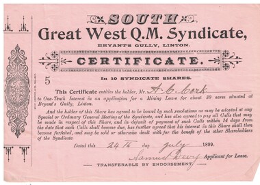
Share certificate, Berry Anderson & Co, Ballarat, South Great West Q.M. Syndicate, 1899, 1899
The certificate was issued to A. C. Cork and entitled him to a one-tenth interest in an application for a mining lease at Bryant's Gully, Linton.Pink paper, black printing, headed South Great West Q.M. Syndicate, dated 24th July 1899, signed Samuel Devy. Decorative design printed in left hand margin. Number "5" on certificate. Serrated left edge of certificate suggests it was detached from a booklet or form.Text: " SOUTH / Great West Q.M. Syndicate, BRYANT'S GULLY, LINTON. "south great west q.m. syndicate, gold mining, mining leases, mining share certificates, a.c. cork -
 Whitehorse Historical Society Inc.
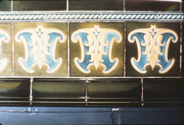
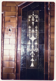
Photograph, South British Building
Coloured photo of tiles in South British Building, 19-25 Queen Street, Melbourne. Demolished 1972south british building, australian tesselated tile co. pty. ltd. -
 Whitehorse Historical Society Inc.
Photograph, South British building
Coloured photo of tiles in South British Building, 19-25 Queen Street, Melbourne. Demolished 1972south british building, australian tesselated tile co. pty. ltd. -
 Whitehorse Historical Society Inc.
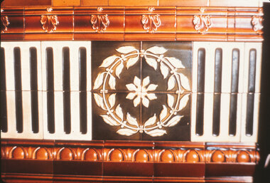
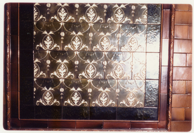
Photograph, South British Building
Coloured photo of tiles in South British Building, 19-25 Queen Street, Melbourne. Demolished 1972south british building, australian tesselated tile co pty ltd -
 Whitehorse Historical Society Inc.
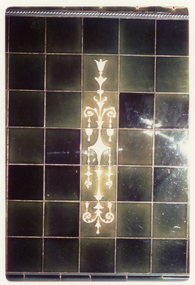
Photograph, South British Building
Coloured photo of tiles in South British Building, 19-25 Queen Street, Melbourne. Demolished 1972south british building, australian tesselated tile co. pty. ltd. -
 Whitehorse Historical Society Inc.
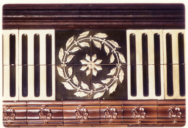
Photograph, South British building
Coloured photo of tiles in south British Building, 19-25 queen Street, Melbourne. Demolished 1972south british building, australian tesselated tile co. pty. ltd. -
 Whitehorse Historical Society Inc.
Photograph, South British Building
Coloured photo of tiles in South British Building, 19-25 Queen Street, Melbourne. Demolished 1972australian tesselated tile co. pty. ltd, south british building -
 Bendigo Military Museum
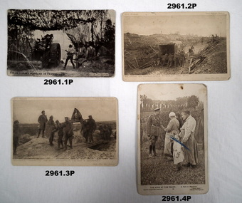
Postcard - POSTCARDS, PHOTOGRAPHS WW1, Daily Mail Series 6, 10 & 12, c.1914 - 1918
Black & white postcard / photos of France during WWI.Rectangular black & white cardboard postcards / photographs..1) - .5) “Handwritten descriptions”documents - postcards, military history, post card, passchendaele barracks trust -
Glenelg Shire Council Cultural Collection
Book, Ira D. Sankey, Sacred Songs and Solos and New Hymns and Solos, n.d
Maroon cloth binding over carboard covers, with title and author in gold on spine and cover, within framing design. Repairs made to spine with green thread stiching visible on both edges of spine.Front: W.S. Malseed (black ink, front page verso) (numbers in pencil on same page) Back: (no inscriptions) -
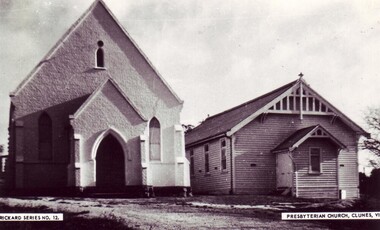 Clunes Museum
Photograph, RICHARD SERIES NO.12
PHOTOGRAPH OF PRESBYTERIAN CHURCH, AND SUNDAY SCHOOL CLUNES. (6 copies)church, presbyterian, photograph -
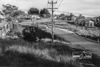 Eltham District Historical Society Inc
Photograph, Looking south along Para Road at intersection of Alma Street and Lees Road, Lower Plenty, c.July 1967, 1967
Old community hall (long wall with row of windows) and Lower Plenty Kindergarten visible at corner of Glenauburn and Para Roads. Packaged in "Filmpro King Size prints Definitely Better EST. 1918" envelope. Pencil notes: 36 shots $2.87 Eltham Shire J. McD and 19/7/67. Alma Street and Kett Street Lower Plenty c.July 1967.Black and white photographalma street, glenauburn road, carisbrook crescent, lees road, lower plenty, lower plenty kindergarten, para road, houses, streets -
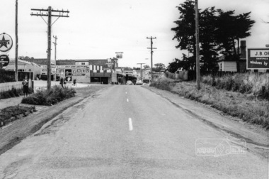 Eltham District Historical Society Inc
Photograph, Looking south along Main Road from Diamond Street Railway Crossing, Eltham, February 1968, Feb 1968
Luck Street enters Main Road from the left behind the Caltex garage. Note the house on right hand land.In February 1968 an unknown person took a series of photos from the Eltham Hotel at Pitt Street heading north along Main Road through the shopping centre to just north of Elsa Court covering the length of the section of Main Road which was duplicated shortly thereafter. Shows the condition and environment of the streesscape of Main Road, Eltham immediately prior to the duplication between Pitt Street and Elsa Court through the shopping centre. Also shows a number of shops and businesses that operated at that time.Black and white photographduplication, eltham, main road, diamond street, railway line, railway crossing, caltex service station, supa-value self service -
Whitehorse Historical Society Inc.
Map, City of Nunawading Street and Block Map
City of Nunawading Street and Block map.City of Nunawading Street and Block map. Scale: 1:10,000. with enlargement, Canterbury Road South to Burwood Highway.City of Nunawading Street and Block map. canterbury road nunawading, burwood highway burwood east, city of nunawading -
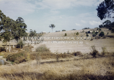 Eltham District Historical Society Inc
Colour Print, David Taylor, View from the rear Eltham High School looking south to Ely Street, Eltham, c.1976
View taken from end of present-day Cronus Court. The tree line on the far right runs beside Porter Street.david taylor collection, eltham, eltham high school, fabbro's farm, cronus court -
 Victorian Railway History Library
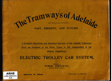
Book, Australian Electric Transport Museum (South Australia), The tramways of Adelaide, 197?
Facsimile production of "The Tramways of Adelaide" published by The Critic, March 9, 1909. It is a complete illustrated and historical souvenir of the Adelaide tramways from the inception of the horse trams to the inauguration of the present magnificent electric trolley car systemIll, maps, p.50.non-fictionFacsimile production of "The Tramways of Adelaide" published by The Critic, March 9, 1909. It is a complete illustrated and historical souvenir of the Adelaide tramways from the inception of the horse trams to the inauguration of the present magnificent electric trolley car systemtramways - adelaide, local transit - adelaide -
 Mordialloc College Alumni Association Inc (MCAA)
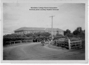
Photograph, 1954 Mordialloc-Chelsea High School and Station Street Railway Crossing Aspendale, 1954
Station Street Railway Crossing and Mordialloc-Chelsea High School. Photo courtesy of past student Heather Donovan nee Padman, -
Lakes Entrance Historical Society
Book, Leary, Frank and Judith, Colonial Heritage Historic Buildings of New South Wales, 1972
A pictorial study of over 250 early buildings of New South Wales, including historical descriptions. Sites of buildings are Sydney, Parramatta, Campbelltown, Windsor, Newcastle, The Blue Mountains, Bathurst, and locations from Mittagong to Canberra.architecture, social history, land settlement, bridges -
 Ballarat Heritage Services
Photograph - Colour, Craig's Hotel, Ballarat
Colour photograph of Craig's hotel in Lydiard Street South, Ballarat.craig's hotel, ballarat, lydiard street south -
 Glen Eira Historical Society
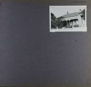
Album - Album page, Meadow Street, Circa 1972
This photograph is part of the Caulfield Historical Album 1972. This album was created in approximately 1972 as part of a project by the Caulfield Historical Society to assist in identifying buildings worthy of preservation. The album is related to a Survey the Caulfield Historical Society developed in collaboration with the National Trust of Australia (Victoria) and Caulfield City Council to identify historic buildings within the City of Caulfield that warranted the protection of a National Trust Classification. Principal photographer thought to be Trevor Hart, member of Caulfield Historical Society. Most photographs were taken between 1966-1972 with a small number of photographs being older and from unknown sources. All photographs are black and white except where stated, with 386 photographs over 198 pages. Page 134 of Photograph Album with one landscape photograph of a Victorian house on Meadow Street.Handwritten: Meadow Street [top right] / 134 [bottom right]trevor hart, east st kilda, decorative brackets, picket fence, slate roof, chimneys, garden, cast iron columns, cast iron frieze, meadow street, st kilda east, caulfield, victorian style, cast iron work, verandahs -
 Federation University Historical Collection
Photograph, St Patrick's Cathedral Presbytery, Ballarat, 2020, 13/04/2020
Colour photograph of a former corner store in Lyons Street South, Ballarat, near the intersection of Sebastopol Street.ballarat, lyons street south, architecture -
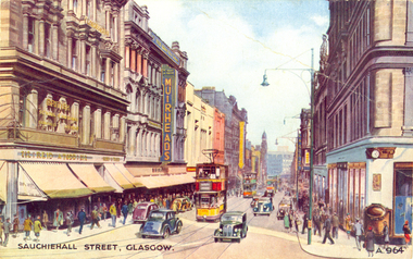 Federation University Historical Collection
Postcard - colour, Sauchiehall Street, Glasgow
auchiehall Street /ˈsʌxihɔːl/ is one of the main shopping/business streets in the city centre of Glasgow, Scotland. Along with Buchanan Street and Argyle Street, it forms the main shopping area of Glasgow, containing the majority of Glasgow's high street and chain stores.[1] Although commonly associated with the city centre, Sauchiehall street is over 11⁄2 miles (2.5 km) long, finally meeting Argyle Street in the West End, in front of the Kelvingrove Museum, where they form Dumbarton Road which continues through Partick. The two streets run parallel through the city centre, before starting to conjoin westward of the M8 motorway at Charing Cross. (Wikipedia)Colour postcard of a street with cars, double decker buses and four storey buildings. The street is Sauchiehall Street, Glasgow, Scotland.chatham-holmes family collection, glasgow, scotland, double decker bus